Bala, Gwynedd

Last updated

Bala
Bala High Street.jpg
Bala High Street
Gwynedd UK location map.svg
Red pog.svg
Bala
Location within Gwynedd
Population1,999 (2021)
OS grid reference SH925359
  Cardiff 142.3 miles
  London 207 miles
Community
  • Bala
Principal area
Preserved county
Country Wales
Sovereign state United Kingdom
Post town BALA
Postcode district LL23
Dialling code 01678
Police North Wales
Fire North Wales
Ambulance Welsh
UK Parliament
Senedd Cymru – Welsh Parliament
Councillors
List of places
UK
Wales
Gwynedd
52°54′40″N3°35′46″W / 52.911°N 3.596°W / 52.911; -3.596

Bala (Welsh : Y Bala) is a town and community in Gwynedd, Wales. Formerly an urban district, Bala lies in the historic county of Merionethshire, at the north end of Bala Lake (Welsh : Llyn Tegid). According to the 2021 Census, Bala had a population of 1,999 [1] and 72.5 per cent of the population could speak Welsh [2] with a decrease of 6% since 2011. [3]

Contents

Toponym

The Welsh word bala refers to the outflow of a lake. [4]

History

Tomen y Bala Tomen y Bala - a Norman motte - geograph.org.uk - 462982.jpg
Tomen y Bala
Neuadd y Cyfnod (English: Period Hall. Formerly the grammar school) Neuadd y Cyfnod, Bala - geograph.org.uk - 432755.jpg
Neuadd y Cyfnod (English: Period Hall. Formerly the grammar school)

Tomen Y Bala (30 feet (9 m) high by 50 feet (15 m) diameter) is a tumulus or "moat-hill", formerly thought to mark the site of a Roman camp.

In the 18th century, the town was well known for the manufacture of flannel, stockings, gloves and hosiery.

The large stone-built theological college, Coleg y Bala, of the Calvinistic Methodists and the grammar school (now Ysgol y Berwyn), which was founded in 1712, are the chief features, together with the statue of the Rev. Thomas Charles (1755–1814), the theological writer, to whom was largely due the foundation of the British and Foreign Bible Society. [5] In 1800 a 15-year-old girl, Mary Jones, walked the 25 miles (40 km) from her home village Llanfihangel-y-Pennant to purchase a Welsh bible in Bala. The scarcity of the Bible, along with the determination of Mary to get one (she had saved for six years), was a major factor in the foundation of the British and Foreign Bible Society in 1804.

Betsi Cadwaladr, who worked with Florence Nightingale in the Crimea, and who gave her name to the Health Board, came from Bala. Other famous people from the Bala area include Michael D. Jones, Christopher Timothy, Owen Morgan Edwards, born in Llanuwchllyn, and T.E. Ellis, born in Cefnddwysarn.

Bala hosted the National Eisteddfod in 1967, 1997 and 2009. The 2009 Eisteddfod was notable because the chair was not awarded to any of the entrants as the standard was deemed to be too low. [6] Bala hosted the Eisteddfod Genedlaethol yr Urdd Gobaith Cymru, National Eisteddfod for the Welsh League of Youth, in 2014. On 16 June 2016, Bala's name was changed to Bale temporarily in honour of Real Madrid forward Gareth Bale. This was only for the duration of UEFA Euro 2016. [7]

Twinning

Bala, Ontario, Canada, was named after the town in 1868. They have become twin towns.

Demographics

Languages

According to the United Kingdom Census 2021, 72.5 per cent of all usual residents aged 3+ in Bala can speak Welsh. [8]

The 2011 census noted 78.5 per cent of all usual residents aged 3 years and older in the town could speak Welsh. The Welsh-language skills of Bala residents were as follows in 2011 and 2021:

Welsh language skill [9] [10] Number and % of persons aged 3+

(2011)

Number and % of persons aged 3+

(2021)

Change

(%)

One or more Welsh language skills1,607 (85.1%)1,550 (79.6%)-5.5
Can understand spoken Welsh1,472 (77.9%)1,424 (73.2%)-4.7
Can speak, read or write Welsh1,503 (79.6%)
Can speak Welsh1,482 (78.5%)1,410 (72.5%)-6.0
Can read Welsh1,367 (72.4%)1,294 (66.5%)-5.9
Can write Welsh1,287 (68.1%)1,256 (64.6%)-3.5
Can speak, read and write Welsh1,271 (67.3%)1,209 (62.1%)-5.2
Total aged 3+1,8891,945

Identity

According to the 2011 Census, 70.5 per cent of the population noted that they had Welsh-only national identity, with 22.2 per cent noting that they had no Welsh national identity at all. [11] According to the 2021 Census, 64.8 per cent of the population noted that they had Welsh-only national identity.

Geography

Set within the Bala Fault, Bala Lake (Welsh : Llyn Tegid) is the largest natural lake in Wales at 3.7 miles (6.0 km) in length and 800 metres (870 yards) wide. At 35 metres (115 feet), its depths could hide the tower of St Giles Church in Wrexham and still have 1 metre (3.3 feet) of water above. The lake has occasionally been known to freeze over, most recently in the severe winters of 1947 and 1963. The rare Gwyniad fishtrapped in the lake at the end of the last ice age, some 10,000 years agois in danger because its natural home is increasingly unsuitable. [12] A member of the whitefish family, it is found only in the lake.

Cwm Hirnant, a valley running south from Bala, gives its name to the Hirnantian Age in the Ordovician Period of geological time.

The closest major urban areas to Bala are Wrexham at 30 miles (48 km), Chester at 40 miles (64 km), and Liverpool, 52 miles (84 km) to the northeast. Nearby villages include Llanfor, Llandderfel, Llanycil, Llangower, Llanuwchllyn, Rhyd-uchaf and Rhos-y-gwaliau.

Climate

As with the rest of the UK, Bala benefits from a maritime climate, with limited seasonal temperature ranges, and generally moderate rainfall throughout the year.

Climate data for Bala 163 metres (535'), 1971–2000
MonthJanFebMarAprMayJunJulAugSepOctNovDecYear
Mean daily maximum °C (°F)6.7
(44.1)
6.8
(44.2)
8.7
(47.7)
11.1
(52.0)
14.6
(58.3)
16.8
(62.2)
19.1
(66.4)
18.8
(65.8)
16.2
(61.2)
12.9
(55.2)
9.4
(48.9)
7.5
(45.5)
12.4
(54.3)
Mean daily minimum °C (°F)0.9
(33.6)
0.8
(33.4)
2.1
(35.8)
2.8
(37.0)
5.2
(41.4)
8.0
(46.4)
10.2
(50.4)
9.8
(49.6)
8.0
(46.4)
5.6
(42.1)
3.0
(37.4)
1.6
(34.9)
4.8
(40.7)
Source: YR.NO [13]
Climate data for Bala (163 metres; 535' elevation) 1981–2010
MonthJanFebMarAprMayJunJulAugSepOctNovDecYear
Mean daily maximum °C (°F)7.0
(44.6)
7.1
(44.8)
9.1
(48.4)
11.7
(53.1)
15.0
(59.0)
17.3
(63.1)
19.3
(66.7)
18.9
(66.0)
16.7
(62.1)
13.2
(55.8)
9.8
(49.6)
7.2
(45.0)
12.7
(54.9)
Mean daily minimum °C (°F)1.0
(33.8)
0.7
(33.3)
2.1
(35.8)
3.0
(37.4)
5.5
(41.9)
8.3
(46.9)
10.5
(50.9)
10.2
(50.4)
8.1
(46.6)
5.7
(42.3)
3.3
(37.9)
1.0
(33.8)
5.0
(41.0)
Average rainfall mm (inches)154.8
(6.09)
111.3
(4.38)
108.3
(4.26)
76.8
(3.02)
72.8
(2.87)
67.8
(2.67)
69.7
(2.74)
81.6
(3.21)
97.5
(3.84)
149.5
(5.89)
143.1
(5.63)
162.1
(6.38)
1,295.2
(50.99)
Average rainy days (≥ 1.0 mm)17.012.415.412.012.011.111.312.712.016.216.816.7165.6
Mean monthly sunshine hours 31.956.683.5135.1168.1149.9155.2145.4109.881.840.824.51,182.3
Source: metoffice.gov.uk [14]
Bala Mill Falls (lower Tryweryn) Bala Mill Falls - geograph.org.uk - 1231649.jpg
Bala Mill Falls (lower Tryweryn)

Attractions

Coleg y Bala Coleg y Bala - geograph.org.uk - 572350.jpg
Coleg y Bala
Bala Town Hall Building on Bala High Street - geograph.org.uk - 1426193.jpg
Bala Town Hall

The Afon Tryweryn, a river fed from Llyn Celyn which runs through Bala, is world-famous for its white water kayaking. International governing bodies, the International Canoe Federation, the European Canoe Union and the British Canoe Union all hold national and international events there. The Canolfan Tryweryn National Whitewater Centre has its home in Bala. There are at least three local campsites that cater for the influx of canoeists from many parts of the world.

An annual music festival known as 'Wa Bala' is also held in the town. The venue hosts local Welsh bands and is similar in format to Dolgellau's Sesiwn Fawr.

Nearby are the mountains Aran Fawddwy and Arenig Fawr.

Coleg y Bala is at the top of the hill on the road towards Llyn Celyn. The Victoria Hall is a small old cinema, that had been a community hall. There are several chapels: notably Capel Mawr and Capel Bach. The livestock market on Arenig Street is still going strong. Bro Eryl estate was built just after World War II. Mary Jones World, a heritage centre about Mary Jones and her Bible is located just outside the town in nearby Llanycil.

Bala Town Hall, which now operates as a restaurant, dates back to circa 1800. [15]

Transport

Railway stations in Bala
BSicon WDOCKSm.svg
BSicon WDOCKSm.svg
BSicon exCONTg.svg
BSicon WDOCKSm.svg
BSicon WDOCKSm.svg
BSicon exBHF.svg
Bala (New)
BSicon WDOCKSm.svg
BSicon WDOCKSrf.svg
BSicon exSTR.svg
Bala Lake Halt
BSicon exSTR.svg
Bala (Penybont)
BSicon uCONTgq.svg
BSicon uKBHFeq.svg
BSicon exSTRq.svg
BSicon exABZql.svg
BSicon exBHFq.svg
BSicon exCONTfq.svg
Bala Junction

Bala has been served by various railway stations on the Great Western Railway: [16]

The Bala Lake Railway (Welsh : Rheilffordd Llyn Tegid) runs for 4.5 miles (7.2 km) from Llanuwchllyn to the edge of the town, along a section of the former trackbed of the Great Western Railway's line between Ruabon and Barmouth. It terminates at Bala (Penybont) railway station, which opened in 1976 on the site of the former Lake Halt station. As of 2020, work is being undertaken to extend the line along the lake foreshore to a new station in the town centre. [17]

Bus services are provided by Lloyds Coaches, as part of the Welsh Government funded TrawsCymru network. Services operate westbound to Barmouth via Dolgellau, and eastbound to Wrexham via Corwen and Llangollen. Through ticketing is available for onward connections at Dolgellau, to Bangor, Machynlleth and Aberystwyth.

The town lies on the A494, a major trunk road that leads to Dolgellau, 18 miles to the southwest, and to Ruthin, Mold and Queensferry to the northwest. The A4212 starts in the town, and crosses the Migneint to Trawsfynydd. Heading southeast, the B4391 crosses the Berwyn range to the English border and the town of Oswestry.

Sport

Bala is home to Cymru Premier football club Bala Town F.C. who play at Maes Tegid. Bala's local rugby club is Bala RFC.

Notable people

Rev. Thomas Charles Bala - The Rev. Thomas Charles B.A. - geograph.org.uk - 408431.jpg
Rev. Thomas Charles

See also

Related Research Articles

<span class="mw-page-title-main">Snowdonia</span> Mountainous region and national park in north Wales

Snowdonia, or Eryri, is a mountainous region and national park in North Wales. It contains all 15 mountains in Wales over 3000 feet high, including the country's highest, Snowdon, which is 1,085 metres (3,560 ft) tall. These peaks are all part of the Snowdon, Glyderau, and Carneddau ranges in the north of the region. The shorter Moelwynion and Moel Hebog ranges lie immediately to the south.

<span class="mw-page-title-main">Porthmadog</span> Town in Gwynedd, Wales

Porthmadog, originally Portmadoc until 1974 and locally as "Port", is a coastal town and community in the Eifionydd area of Gwynedd, Wales, and the historic county of Caernarfonshire. It lies 5 miles (8 km) east of Criccieth, 11 miles (18 km) south-west of Blaenau Ffestiniog, 25 miles (40 km) north of Dolgellau and 20 miles (32 km) south of Caernarfon. The community population of 4,185 in the 2011 census was put at 4,134 in 2019. It grew in the 19th century as a port for local slate, but as the trade declined, it continued as a shopping and tourism centre, being close to Snowdonia National Park and the Ffestiniog Railway. The 1987 National Eisteddfod was held there. It includes nearby Borth-y-Gest, Morfa Bychan and Tremadog.

<span class="mw-page-title-main">River Dee, Wales</span> River in Wales and England

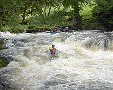
The River Dee is a river flowing through North Wales, and through Cheshire, England, in Great Britain. The length of the main section from Bala to Chester is 113 km and it is largely located in Wales. The stretch between Aldford and Chester is within England, and two other sections form the border between the two countries.

<span class="mw-page-title-main">Bala Lake</span> Lake in Gwynedd, Snowdonia, Wales

Bala Lake is a large freshwater glacial lake in Gwynedd, Wales. The River Dee, which has its source on the slopes of Dduallt in the mountains of Snowdonia, feeds the 3.7 miles (6.0 km) long by 0.5 miles (0.8 km) wide lake. It was the largest natural body of water in Wales even before its level was raised by Thomas Telford to provide water for the Ellesmere Canal.

<span class="mw-page-title-main">Pwllheli</span> Town in north-west Wales

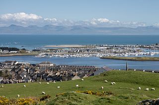
Pwllheli is a market town and community on the Llŷn Peninsula, north-west Wales. It lies in the traditional county of Caernarfonshire but is currently administered as part of the unitary authority of Gwynedd. It had a population of 4,076 in 2011, the population declining slightly to 3,947 in 2021. of whom a large proportion, 81%, were Welsh speaking. Pwllheli is the place where Plaid Cymru was founded. It is the birthplace of the Welsh poet Sir Albert Evans-Jones.

<span class="mw-page-title-main">Llanberis</span> Village in North Wales

Llanberis is a village, community and electoral ward in Gwynedd, northwest Wales, on the southern bank of the lake Llyn Padarn and at the foot of Snowdon, the highest mountain in Wales. It is a centre for outdoor activities in Snowdonia, including walking, mountaineering, climbing, mountain biking and pony trekking, as well as water sports such as scuba diving. The community includes Nant Peris.

<span class="mw-page-title-main">Dolgellau</span> Town in Gwynedd, Wales

Dolgellau is a town and community in Gwynedd, north-west Wales, lying on the River Wnion, a tributary of the River Mawddach. It was the traditional county town of the historic county of Merionethshire until the county of Gwynedd was created in 1974. Dolgellau is the main base for climbers of Cadair Idris and Mynydd Moel which are visible from the town. Dolgellau is the second largest settlement in southern Gwynedd after Tywyn and includes the community of Penmaenpool.

<span class="mw-page-title-main">Bala Lake Railway</span> Heritage railway line in Gwynedd, Wales

The Bala Lake Railway is a narrow-gauge railway along the southern shore of Bala Lake in Gwynedd, North Wales. The line, which is 4+12 miles (7.2 km) long, is built on a section of the former standard-gauge Ruabon–Barmouth GWR route that closed in 1965. Another section of the former permanent way is used by the Llangollen Railway. The Bala Lake Railway, which runs on 600 mm -gauge preserved rolling stock, is a member of the Great Little Trains of Wales.

<span class="mw-page-title-main">Trawsfynydd</span> Human settlement in Wales

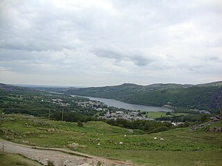
Trawsfynydd is a linear village in Gwynedd, Wales, near Llyn Trawsfynydd reservoir, and adjacent to the A470 north of Bronaber and Dolgellau and 10 km south of Blaenau Ffestiniog. It also neighbours the towns of Porthmadog and Bala.

<span class="mw-page-title-main">Llyn Celyn</span> Artificial lake near Bala in Gwynedd, north Wales

Llyn Celyn is a reservoir constructed between 1960 and 1965 including the highly controversial Tryweryn flooding in the valley of the River Tryweryn in Gwynedd, Wales. This included the forcible removal of the Capel Celyn village residents despite protest and opposition of Welsh MPs.

<span class="mw-page-title-main">Llanuwchllyn</span> Human settlement in Wales

Llanuwchllyn is a village and community in Gwynedd, Wales, near the southern end of Bala Lake. It is one of the most sparsely populated communities in Wales.

The Ruabon–Barmouth line was a standard-gauge line owned by the Great Western Railway across the north of Wales which connected Ruabon, in the east, with Barmouth on the west coast.

<span class="mw-page-title-main">Bala Town F.C.</span> Association football club in Wales

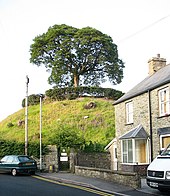
Bala Town Football Club is a Welsh football club from Bala, Gwynedd, who play in the Cymru Premier. They play their home games at Maes Tegid.

<span class="mw-page-title-main">Bala (Penybont) railway station</span> Railway station in Gwynedd, Wales

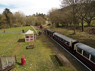
Bala (Penybont) is the current terminus of the heritage Bala Lake Railway, in Gwynedd, Wales, since 1976. The site was formerly the location of the Bala Lake Halt railway station, a former station on the Ruabon to Barmouth line.

<span class="mw-page-title-main">Betsi Cadwaladr University Health Board</span> NHS local health board in North Wales

Betsi Cadwaladr University Health Board (BCUHB) is the local health board of NHS Wales for the north of Wales. It is the largest health organisation in Wales, providing a full range of primary, community, mental health, and acute hospital services for a population of around 694,000 people across the six principal areas of north Wales as well as some parts of Mid Wales, Cheshire and Shropshire. Betsi Cadwaladr University Health Board is the operational name of Betsi Cadwaladr Local Health Board.

<span class="mw-page-title-main">Betsi Cadwaladr</span> Welsh nurse

Betsi Cadwaladr, also known as Beti Cadwaladr and Betsi Davis, was a Welsh nurse. She began nursing on travelling ships in her 30s (1820s) and later nursed in the Crimean War alongside Florence Nightingale. Their different social backgrounds was a source of constant disagreement.

<span class="mw-page-title-main">Rhun ap Iorwerth</span> Welsh journalist and politician

Rhun ap Iorwerth is a Welsh journalist and politician serving as the Leader of Plaid Cymru since June 2023. He has been the Member of the Senedd (MS) for Ynys Môn since 2013.

<span class="mw-page-title-main">Llanycil</span> Human settlement in Wales

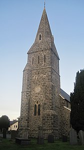
Llanycil is a community in the county of Gwynedd, Wales, near Bala, and is 99.9 miles (160.7 km) from Cardiff and 176.2 miles (283.6 km) from London. In 2011 the population of Llanycil was 416 with 80.4% of them able to speak Welsh. The community includes the small settlements of Parc, Rhyd-uchaf and Llidiardau.

Dafydd Cadwaladr was a Welsh Calvinistic Methodist preacher. He grew up in Llangwm, Denbighshire, where his family had lived for generations. By noting the letters on sheep's backs and then picking his way through the Prayer Book he was able to teach himself to read, and enjoyed reciting works such as the 'Pilgrim's Progress' at the local 'knitting meetings'.

<span class="mw-page-title-main">2022 Gwynedd Council election</span> Local election held for Gwynedd Council in Wales

The 2022 Gwynedd Council election took place on 5 May 2022 to elect 69 members from 65 wards to Gwynedd Council. On the same day, elections were held to the other 21 local authorities and to community councils in Wales as part of the 2022 Welsh local elections. The previous Gwynedd all-council election took place in May 2017 and future elections will take place every five years.

References

  1. "Bala (Community, United Kingdom) - Population Statistics, Charts, Map and Location". www.citypopulation.de. Retrieved 18 December 2022.
  2. "Welsh Language Percentage of people aged three years or older able to speak Welsh by LSOA 2021". Welsh Government DataMapWales. Retrieved 18 March 2023.
  3. "Map newydd | MapDataCymru". mapdata.llyw.cymru. Retrieved 18 December 2022.
  4. Geiriadur Prifysgol Cymru. Vol. a–baldog. University of Wales. 2006. p. 648. Archived from the original on 28 December 2005. Retrieved 27 September 2012.
  5. Wikisource-logo.svg One or more of the preceding sentences incorporates text from a publication now in the public domain :  Chisholm, Hugh, ed. (1911). "Bala". Encyclopædia Britannica . Vol. 3 (11th ed.). Cambridge University Press. p. 231.
  6. "No-one worthy of eisteddfod chair". BBC News . 7 August 2009. Retrieved 13 March 2011.
  7. "Euro 2016: Bala changes name to Bale in honour of Wales star". The Guardian. 16 June 2016. Retrieved 28 July 2021.
  8. "Welsh Language Change in the percentage of people aged three years or older able to speak Welsh by LSOA 2011 to 2021 | DataMapWales". datamap.gov.wales. Retrieved 15 December 2022.
  9. Sillitoe, Neighbourhood Statistics - Neil (14 April 2008). "Detect browser settings". www.neighbourhood.statistics.gov.uk. Archived from the original on 27 February 2017. Retrieved 26 February 2017.
  10. Sillitoe, Neighbourhood Statistics - Neil (14 April 2008). "Detect browser settings". www.neighbourhood.statistics.gov.uk. Archived from the original on 27 February 2017. Retrieved 26 February 2017.
  11. "Ward and area profiles". www.gwynedd.llyw.cymru. Retrieved 7 January 2023.
  12. Freyhof, J. & Kottelat, M. 2008. Coregonus pennantii. In: IUCN Red List of Threatened Species. Version 2010.1. Downloaded on 17 April 2010.
  13. "Climate Normals 1971–2000". YR.NO. Archived from the original on 16 October 2012. Retrieved 3 March 2011.
  14. "Climate Normals 1981–2010". Met Office. Retrieved 24 February 2021.
  15. Cadw. "Town Hall (4916)". National Historic Assets of Wales . Retrieved 26 May 2022.
  16. Butt, R. V. J. (October 1995). The Directory of Railway Stations: details every public and private passenger station, halt, platform and stopping place, past and present (1st ed.). Sparkford: Patrick Stephens Ltd. ISBN   978-1-85260-508-7. OCLC   60251199. OL   11956311M.
    Jowett, Alan (March 1989). Jowett's Railway Atlas of Great Britain and Ireland: From Pre-Grouping to the Present Day (1st ed.). Sparkford: Patrick Stephens Ltd. ISBN   978-1-85260-086-0. OCLC   22311137.
    Jowett, Alan (2000). Jowett's Nationalised Railway Atlas (1st ed.). Penryn, Cornwall: Atlantic Transport Publishers. ISBN   978-0-906899-99-1. OCLC   228266687.
  17. "Welcome". Bala Lake Railway Trust. Retrieved 16 April 2020.
  18. Jenkins, David Erwyd (1911). "Charles, Thomas"  . Encyclopædia Britannica . Vol. 5 (11th ed.). pp. 15–16.