Balmain, New South Wales

Last updated

Balmain
Sydney,  New South Wales
Balmain-Darling-Street.jpg
Balmain, New South Wales
Balmain
Location map Australia Sydney.png
Red pog.svg
Balmain
Coordinates 33°51′32″S151°10′45″E / 33.85895°S 151.17906°E / -33.85895; 151.17906
Population10,454 (SAL 2021) [1]
Established1836
Postcode(s) 2041
Elevation49 m (161 ft)
Area1.5 km2 (0.6 sq mi)
Location5 km (3 mi) west of Sydney CBD
LGA(s) Inner West Council
State electorate(s) Balmain
Federal division(s) Grayndler
Suburbs around Balmain:
Drummoyne Birchgrove
Rozelle Balmain Balmain East
Rozelle Rozelle

Balmain is a suburb in the Inner West [2] of Sydney, New South Wales, Australia. Balmain is located two kilometres (1+14 miles) west of the Sydney central business district, in the local government area of the Inner West Council.

Contents

It is located on the Balmain peninsula surrounded by Port Jackson, adjacent to the suburbs of Rozelle to the south-west, Birchgrove to the north-west, and Balmain East to the east. Iron Cove sits on the western side of the peninsula, with White Bay on the south-east side and Mort Bay on the north-east side.

Traditionally blue collar, Balmain was where the industrial roots of the trade unionist movement began. It has become established in Australian working-class culture and history, due to being the place where the Australian Labor Party formed in 1891 and its social history and status is of high cultural significance to both Sydney and New South Wales. Today, the ALP contends with the Australian Greens for political prominence in Balmain, and Kobi Shetty of the Greens holds the State seat of Balmain.

History

Darling Street around 1888 Balmain, New South Wales - Darling St c1888.jpg
Darling Street around 1888

Prior to European settlement, the area was inhabited by indigenous Aboriginal Australian, Gadigal and Wangal people. Stories from early settlers in the area tell of how the local indigenous people used to hunt kangaroo by driving them through the bushy peninsula, down the hill to Peacock Point at the east end, where they were killed.

The area now known as Balmain was part of a 220-hectare (550-acre) grant to colonial surgeon William Balmain (1762–1803) made in 1800 by Governor John Hunter. A year later, Balmain transferred his entire holding to settle a debt to John Borthwick Gilchrist before returning to Scotland. The legality of the land transfer from Balmain to Gilchrist for only 5 shillings was challenged by Balmain's descendants and further development of the area was blocked. The area subsequently became known as Gilchrist's place, though court documents refer to the area as the Balmain Estate.

During the many years of legal challenges, the land was leased for farming and cattle purposes. In 1814 the adjacent homestead of Birchgrove was sold to Roland Warpole Loane, a merchant and settler descended from a family of English landlords. One hundred acres on the adjoining Balmain estate were leased to Loane. [3]

Lever Brothers Factory 1939 Lever Brothers Balmain - Feb 1939.jpg
Lever Brothers Factory 1939

In 1833, Gilchrist transferred power of attorney to Frederick Parbury. When Loane's lease finally expired in 1836 and the land retrieved from his possession, Parbury commissioned surveyor John Armstrong to sub-divide the land into six parcels. Three parcels were sold to Thomas Hyndes in 1837. The area was rapidly sub-divided and developed during the 1840s and by 1861 had been divided into the well populated eastern suburb of Balmain and the sparsely populated western area, extending to the gates of Callan Park, known as Balmain West.

Early City Subdivision Balmain, Darling St, Elliott St, Terry St, Claremont St City Subdivision Balmain, Darling St, Elliott St, Terry St, Claremont St, 1841-1960.jpg
Early City Subdivision Balmain, Darling St, Elliott St, Terry St, Claremont St

Industry

The peninsula changed rapidly during the 1800s and became one of the premier industrial centres of Sydney. Industries clustered around Mort Bay included shipbuilding, a metal foundry, engineering, boilermaking and the Mort's Dock & Engineering Company works which opened in 1855—in 1958 Mort's Dock closed and is the site of Mort Bay Park. [4] Increasing industrialisation at Balmain created a demand for cheap housing. This was satisfied by the dock owners selling small blocks of land to entrepreneurs who then built tiny cottages and rented them to the workers. The Balmain Reservoir was built in 1915.

An electric tram at Balmain East ferry wharf in 1951 Rozelletram.jpg
An electric tram at Balmain East ferry wharf in 1951

Lever Brothers Factory, owned by the British parent company, opened in 1895.

Colliery

A coal mine was opened in 1897 beside what is now Birchgrove Public School by an English company. The winding engine was said to be the largest in the southern hemisphere. However, with the endless labour disputes, [5] Sydney Collieries Limited took over ownership. A further new shaft was sunk in 1904. From the bottom of the shafts a decline led down to a seam of coal situated under the harbour between Ballast Point and Goat Island. [6] Because of the availability of the coal, Balmain Power Station was erected in stages from 1909. However, there were major industrial disputes in the 1920s and calls were made by some shareholders in 1928 to close the mine. [7] The following year the colliery still employed 299 miners. [8] By 1930 the colliery owners had given up and it had been taken over by the Balmain Coal Contracting Company, established by the Miner's Federation [9] to keep the pit operational, to no avail as disputes continued. On 13 October 1930 the Miners' Lodge declared the mine "blacked" as well as the manager, whose dismissal they demanded. [10] The colliery closed in 1931. In 1933 it was proposed to extract natural gas for commercial use from the now disused mine. [5] In 1936 calls were made for the Sydney City Council to take over the mine to no avail. [11]

One local waterman who benefited from the Balmain coalmine was Bob Miller, who resided at 102 Glassop Street. He purchased a small tug and barge and secured a contract to remove the mine tailings, which he on sold to local councils as fill for a handsome profit. This was the beginning of the RW Miller industrial conglomerate. By 1924 his family had moved to Louisa Road. [12] [13]

Tramway

The opening of the tramway in the 1920s further established Balmain and it gained a reputation as a rough working-class area of Sydney. A large influx of immigrants boosted Balmain's population in the 1950s.

Gentrification

Gentrification of Balmain began in the 1960s as industry waned. Balmain's desirability to the middle class was due in part to its waterfront location and proximity to Sydney's CBD. The Balmain Association was formed in 1965. [14]

Increasing property values and waterfront development continued to push the suburb's remaining industry out. In 1996, the Lever Brothers site became a series of apartment complexes with a handful of original buildings preserved. The power station was demolished in 1998 to make way for apartments. However, many aspects of Balmain's industrial past have been retained as heritage.

Heritage listings

View over Sydney from Balmain Sydney from Balmain 2.jpg
View over Sydney from Balmain

Balmain has a number of heritage-listed sites, including:

Demographics

At the 2021 census, the population of Balmain was 10,454. [22] At the 2016 census, it had a population of 10,453. [23]

In 2021, 64.8% of people were born in Australia. The next most common countries of birth were England 9.1%, New Zealand 2.8%, United States 1.7%, Ireland 1.3% and China 1.2%. 83.4% of people only spoke English at home. Other languages spoken at home included Mandarin 1.5% and Italian at 1.2%. The most common responses for religion in Balmain were no religion 51.9%, Catholic 20.7%, Anglican 9.9%, not stated 5.3% and Eastern Orthodox 2.2%. 37.6% of dwellings were flats, units or apartments, 39.9% were semi-detached terraced houses or townhouses and 21.8% were separate houses. [22]

Commercial area

Balmain features an abundance of alfresco cafes and dining establishments, giving a prominent dining culture to the area Balmain-Shopping-Area.jpg
Balmain features an abundance of alfresco cafes and dining establishments, giving a prominent dining culture to the area
Balmain Working Men's Institute Balmain Working Mens Institute.JPG
Balmain Working Men's Institute
View of the Sydney Harbour Bridge from East Balmain, Barangaroo Reserve is in the foreground Bridge from balmain east.jpg
View of the Sydney Harbour Bridge from East Balmain, Barangaroo Reserve is in the foreground

Darling Street, Balmain's main thoroughfare, features boutique shops, quality restaurants and cafes alongside old drinking establishments. Landmarks on this street include the Post Office and Court House, alongside Balmain Town Hall, the historic Westpac Bank, Balmain Fire Station and Balmain Working Men's Institute. Other commercial developments are scattered throughout the suburb. The headquarters of the NSW Water Police moved to Cameron Cove in Balmain in late 2007.

Transport

Balmain Shipyard 2 Balmain Ferry at the Balmain Shipyard.JPG
Balmain Shipyard

Balmain has several ferry wharves including Thames Street Balmain serviced by the Cockatoo Island ferry services, Elliot Street, Balmain West and Darling Street, Balmain East serviced by the Cross Harbour ferry services. Services run to Circular Quay. Transdev Sydney Ferries' maintenance and repair base is at Balmain Shipyard.

Balmain's road network feeds into three main roads—Darling Street, Beattie Street and Montague/Mullen Street. These streets have limited speeds, typically 40 km/h and are all single carriageway with parallel parking. Due to the geography of the peninsula, all of these roads feed into Victoria Road and the Western Distributor. Sections of Balmain were to be demolished to make for the North-West Expressway but this was prevented after green bans were placed by the NSW Builders Labourers Federation. [24]

Trams once ran all the way down Darling Street to the wharf at Balmain East. Due to the very steep incline at the bottom of the street, the trams used a complex 'dummy' counterweight system constructed under the road surface. The trams were pushed up the steep hill by the dummy, and rode the dummy on the way down to safely descend the hill. Transit Systems bus services that service Balmain are:

Culture

The Balmain bug (Ibacus peronii), a type of slipper lobster commonly eaten in Sydney, is named after Balmain.

Historic hotels

Balmain is home to many historic hotels, including the Cat and Fiddle Hotel, Cricketer's Arms Hotel, Dick's Hotel, Dry Dock Hotel, Exchange Hotel, Forth & Clyde Hotel, Kent Hotel, Unity Hall Hotel, London Hotel, Mort Bay Hotel, Norfolk Pines Hotel, Pacific Hotel, Royal Oak Hotel, Shipwright's Arms Hotel, Star Hotel, Town Hall Hotel, Volunteer Hotel and the West End Hotel.

The Riverview Hotel is a heritage-listed corner building built in 1880 in the Arts and Crafts style. [29] Between 1888 and 1913 the pub was named Bergin's Hotel after the publican Joseph Bergin. Australian swimming champion Dawn Fraser was publican of the Riverview from 1978 to 1983. [30]

Pop culture

Exchange Hotel, Beattie Street Exchange Hotel Balmain 12.JPG
Exchange Hotel, Beattie Street

Numerous phrases have been used to describe the suburb and its inhabitants, including "Balmain boys don't cry" (former NSW Premier Neville Wran at the Street Royal Commission); "You can take the boy out of Balmain, but you can't take Balmain out of the boy" (Unknown); "There are only two types of men in this world: those who were born in Balmain and those who wish they were" (a Police Commissioner of New South Wales). Australian Prime Minister Paul Keating commented on the suburb's gentrification by using the term "Basket weavers of Balmain". Until the 1970s, older Balmain people would refer to "going to Sydney". The Post Office/ Court/ Police building and vicinity was generally referred to as the "Town Hall", with the Post Office clock often called the Town Hall clock. This was probably due to the Post Office & Court Building being built in between the earlier Town Hall & Town Hall Hotel.

In the mid-1960s Balmain was the setting for the popular Seven Network situation comedy series My Name's McGooley, What's Yours? , starring Gordon Chater, John Meillon and Judi Farr. [31]

Balmain was the setting for the 1994 Australian film The Sum of Us , which starred Jack Thompson, John Polson and Russell Crowe. [32]

The former Pacific Hotel (from 2019, now converted into a residential property) - as well as several other locations in Balmain - were used extensively as the set of the Australian television soap opera, E Street .

Parks and reserves

Public open space on the shores of Mort Bay on the Balmain, Balmain East border 1. east balmain park on mort bay syd harbour.jpg
Public open space on the shores of Mort Bay on the Balmain, Balmain East border

Balmain has a number of parks including Gladstone Park, Birrung Park and White Bay Park. The wider peninsula has many more parks in close proximity, particularly along the foreshores. In earlier times Punch Park was the goto place for park footy (rugby league), though it was always referred to by the boys then as Punch's Park

Sport and recreation

Balmain is home to the Balmain Tigers district rugby league football club that is now represented in the NRL by Wests Tigers rugby league club. The club was formed in mid-1999 by a joint venture between the Balmain Tigers and the Western Suburbs Magpies in preparation for the 2000 season. [33] In 2005 the Tigers defeated the North Queensland Cowboys in the Grand Final to win the premiership. [33]

The Balmain Rugby Football Club, founded in 1873, took part in the very first competition structure and in fact winning their first premiership in 1875. Players lost fighting in World War I forced the club to merge with the Glebe "Dirty Reds" RUFC in 1919, to form the Glebe-Balmain RFC. As a merged club they had enormous success during the Twenties, winning four premierships. In 1931, as a depression project, Drummoyne Oval, as it is now known, was constructed on the site of a small oval which Glebe and Balmain had used for junior matches since 1892. To ensure longevity of tenure, and because there were just not enough sporting grounds in Sydney—with some reluctance—the Glebe-Balmain Club decided to change its name to the Drummoyne District Rugby Football Club. [34] It did so without giving up its long-held traditions, the scarlet jumpers of Glebe and its world-famous tag, "The Dirty Reds" and the black and gold of Balmain, colours still worn proudly by today's players in their socks. Drummoyne Rugby Club [34] is still in existence and still upholds it proud history and traditions.

The suburb is also home to the Balmain Australian Football Club, a founding member in 1903 of the Sydney Football League. [35]

Balmain is also home to Balmain FC, who are a semi-professional football club, playing in the National Premier Leagues NSW 3. In 2015 they qualified for the Australia-wide FFA Cup Round of 32 and were drawn against A-League club Melbourne Victory FC in which they were defeated 6–0 in front of 5,000 fans at Leichhardt Oval.

Balmain Sailing Club is located in nearby Birchgrove and is home to the annual Balmain Regatta.

Balmain Rowing Club was formed in July 1882, and still occupies its original White Street location. The club adopted black and yellow colours from its formation, which soon became the district colours. The great Illawarra sculling champion Bill Beach had a close association with the club and wore their black and gold colours in competition.

Housing

The post-industrial gentrification of Balmain has resulted in a suburb of considerable charm and interest where the modest, pretty houses command high prices. However, Balmain still retains a diverse mix of residents due to the Housing Commission unit blocks in the suburb. [36] [37] Much of the suburb is a heritage conservation area and creative design is required to modernise the Victorian and Edwardian housing stock. In 2013 a contemporary Balmain house designed by architect Harry Seidler sold for $6m. [38] The Tom Uren House in Gilchrist Place was designed by Richard Leplastrier.

Notable residents

Henry Parkes Residence Hampton Villa Balmain, New South Wales Henry Parkes.jpg
Henry Parkes Residence Hampton Villa

Notable past and present residents include:

Notes

  1. ^ Postcode 2041 covers the suburbs of Balmain, Balmain East and Birchgrove.
  2. ^ Combined population for all residents of postcode 2041.
  3. ^ Median house price for all properties of postcode 2041.

Related Research Articles

<span class="mw-page-title-main">Redfern, New South Wales</span> Inner suburb of Sydney, Australia

Redfern is an inner southern suburb of Sydney located 3 kilometres (1.9 mi) south of the Sydney central business district and is part of the local government area of the City of Sydney. Strawberry Hills is a locality on the border with Surry Hills. The area experienced the process of gentrification and is subject to extensive redevelopment plans by the state government, to increase the population and reduce the concentration of poverty in the suburb and neighbouring Waterloo.

<span class="mw-page-title-main">Ryde, New South Wales</span> Suburb of Sydney, New South Wales, Australia

Ryde is a suburb of Sydney, New South Wales, Australia. Ryde is located 13 km north-west of the Sydney central business district and 8 km east of Parramatta. Ryde is the administrative centre of the local government area of the City of Ryde and part of the Northern Sydney region. It lies on the north bank of the Parramatta River. People from Ryde are colloquially known as Ryders, Rydiens or Rydemen.

<span class="mw-page-title-main">Hunters Hill, New South Wales</span> Suburb of Sydney, New South Wales, Australia

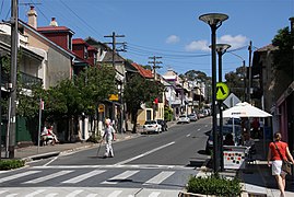
Hunters Hill is a suburb of Northern Sydney, in the state of New South Wales, Australia. Hunters Hill is located 9 kilometres (5.6 mi) north-west of the Sydney central business district and is the administrative centre for the local government area of the Municipality of Hunter's Hill.

<span class="mw-page-title-main">Randwick, New South Wales</span> Suburb of Sydney, New South Wales, Australia

Randwick is a suburb in the Eastern Suburbs of Sydney, in the state of New South Wales, Australia. Randwick is located 6 kilometres south-east of the Sydney central business district and is the administrative centre for the local government area of the City of Randwick. The postcode is 2031.

<span class="mw-page-title-main">North Sydney, New South Wales</span> Suburb of Sydney, New South Wales, Australia

North Sydney is a suburb and major commercial district on the Lower North Shore of Sydney, New South Wales, Australia. It is located three kilometres north of the Sydney central business district and is the administrative centre for the local government area of North Sydney Council.

<span class="mw-page-title-main">Francis Greenway</span> Architect

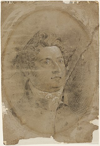
Francis Howard Greenway was an English-born architect who was transported to Australia as a convict for the crime of forgery. In New South Wales he worked for the Governor, Lachlan Macquarie, as Australia's first government architect. He became widely known and admired for his work displayed in buildings such as St Matthew's Church, St James' Church and Hyde Park Barracks.

<span class="mw-page-title-main">Glebe, New South Wales</span> Suburb of Sydney, New South Wales, Australia

Glebe is an inner-western suburb of Sydney in New South Wales. Glebe is located 3 kilometres (1.9 mi) southwest of the Sydney central business district and is part of the local government area of the City of Sydney, in the Inner West region.

<span class="mw-page-title-main">Lilyfield, New South Wales</span> Suburb of Sydney, New South Wales, Australia

Lilyfield is a suburb in the Inner West of Sydney, in the state of New South Wales, Australia. Lilyfield is located 6 kilometres west of the Sydney central business district, in the local government area of the Inner West Council.

<span class="mw-page-title-main">Pyrmont, New South Wales</span> Suburb of Sydney, New South Wales, Australia

Pyrmont is an inner-city suburb of Sydney, in the state of New South Wales, Australia 2 kilometres south-west of the Sydney central business district in the local government area of the City of Sydney. It is also part of the Darling Harbour region. As of 2011, it is Australia's most densely populated suburb.

<span class="mw-page-title-main">Double Bay</span> Suburb of Sydney, New South Wales, Australia

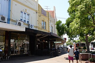
Double Bay is a harbourside eastern suburb of Sydney, in the state of New South Wales, Australia 4 kilometres east of the Sydney central business district. It is the administrative centre of the local government area of the Municipality of Woollahra.

<span class="mw-page-title-main">Ultimo, New South Wales</span> Suburb of Sydney, New South Wales, Australia

Ultimo is an inner-city suburb of Sydney, New South Wales, Australia. It is adjacent to the Sydney central business district in the local government area of the City of Sydney west of the Darling Harbour area, and is bordered by Pyrmont to the north, the Sydney CBD and Chinatown/Haymarket to the east, Broadway and Chippendale to the south, and Glebe and Wentworth Park to the west.

<span class="mw-page-title-main">Rozelle</span> Suburb of Sydney, New South Wales, Australia

Rozelle is a suburb in the inner west of Sydney, in the state of New South Wales, Australia. It is located 4 kilometres west of the Sydney central business district, in the local government area of the Inner West Council.

<span class="mw-page-title-main">Alexandria, New South Wales</span> Suburb of Sydney, New South Wales, Australia

Alexandria is an inner southern suburb of Sydney, New South Wales, Australia. Alexandria is located 5 kilometres south of the Sydney central business district and is part of the local government area of the City of Sydney. The postcode is 2015.

<span class="mw-page-title-main">Drummoyne</span> Suburb of Sydney, New South Wales, Australia

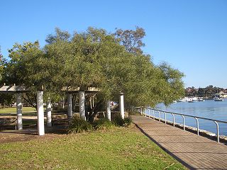
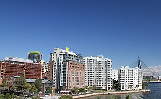
Drummoyne is a suburb in the Inner West of Sydney, in the state of New South Wales, Australia. Drummoyne is six kilometres west of the Sydney central business district and is the administrative centre for the local government area of the City of Canada Bay.

<span class="mw-page-title-main">Balmain East</span> Suburb of Sydney, New South Wales, Australia

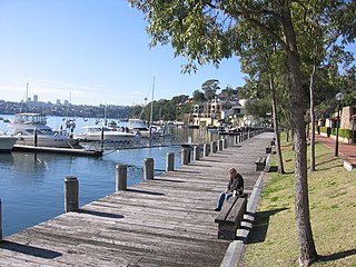
Balmain East is a suburb in the Inner West of Sydney, in the state of New South Wales, Australia. Balmain East is located three kilometres west of the Sydney central business district, in the local government area of the Inner West Council.

<span class="mw-page-title-main">Birchgrove, New South Wales</span> Suburb of Sydney, New South Wales, Australia

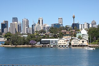
Birchgrove is a suburb in the Inner West of Sydney, in the state of New South Wales, Australia. Birchgrove is located five kilometres west of the Sydney central business district, in the local government area of the Inner West Council.

<span class="mw-page-title-main">Sir William Wallace Hotel</span>

The Sir William Wallace Hotel was an historic pub in the suburb of Birchgrove on the Balmain Peninsula in the inner west region of Sydney, in the state of New South Wales, Australia.

The 1909 New South Wales Rugby Football League premiership was the second season of Sydney's top-level rugby league football competition, Australia's first. Eight teams contested during the season for the premiership and the Royal Agricultural Society Challenge Shield; seven teams from Sydney and one team from Newcastle, New South Wales.

<span class="mw-page-title-main">Annandale, New South Wales</span> Suburb of Sydney, New South Wales, Australia

Annandale is a suburb in the Inner West of Sydney, in the state of New South Wales, Australia. Annandale is located within 5 kilometres west of the Sydney central business district and is part of the local government area of the Inner West Council. Annandale's northern end lies on Rozelle Bay, which is on Sydney Harbour. Glebe lies to its east, Lilyfield and Leichhardt to its west and Stanmore and Camperdown to its south.

George Allen Mansfield was a prominent Australian architect of the nineteenth century who designed many iconic buildings in Sydney, New South Wales, Australia.

References

  1. Australian Bureau of Statistics (28 June 2022). "Balmain (suburb and locality)". Australian Census 2021 QuickStats. Retrieved 28 June 2022.  OOjs UI icon edit-ltr-progressive.svg
  2. Australian Suburb Guide: Sydney Inner West Archived 26 December 2012 at the Wayback Machine Retrieved 7 August 2013.
  3. The Book of Sydney Suburbs, Compiled by Frances Pollon, Angus & Robertson, 1990, ISBN   0-207-14495-8, p.14
  4. "Mort Bay Park". Inner West Council. Retrieved 26 December 2016.
  5. 1 2 Cessnock Eagle & South Maitland Recorder 17 November 1933, p.1.
  6. Lawrence, J; Warne, C; A Pictorial History of Balmain to Glebe, Kingsclear Books, 1995, ISBN   0-908272-40-5.
  7. Newcastle Sun Monday 18 June 1928, p.6.
  8. Newcastle Morning Herald Sat 30 Nov 1929, p.29.
  9. Evening News, Sydney, 4 April 1930, p.7.
  10. Barrier Miner 14 October 1930, p.1.
  11. The Sun , 22 April 1936, p.6.
  12. Sands Directory 1918
  13. The Watermen of Sydney Memories of a Working Harbour. Graeme Andrews.
  14. "Australia Network - Nexus - Balmain". Archived from the original on 17 April 2012. Retrieved 20 June 2011.
  15. "Ewenton". New South Wales State Heritage Register . Department of Planning & Environment. H00197. Retrieved 18 May 2018. CC BY icon.svg Text is licensed by State of New South Wales (Department of Planning and Environment) under CC-BY 4.0 licence .
  16. "Balmain Hospital - Main Building". New South Wales State Heritage Register . Department of Planning & Environment. H00814. Retrieved 18 May 2018. CC BY icon.svg Text is licensed by State of New South Wales (Department of Planning and Environment) under CC-BY 4.0 licence .
  17. "Dawn Fraser Swimming Pool". New South Wales State Heritage Register . Department of Planning & Environment. H01398. Retrieved 18 May 2018. CC BY icon.svg Text is licensed by State of New South Wales (Department of Planning and Environment) under CC-BY 4.0 licence .
  18. "Hampton Villa". New South Wales State Heritage Register . Department of Planning & Environment. H01725. Retrieved 18 May 2018. CC BY icon.svg Text is licensed by State of New South Wales (Department of Planning and Environment) under CC-BY 4.0 licence .
  19. "Waterview Wharf Workshops". New South Wales State Heritage Register . Department of Planning & Environment. H00687. Retrieved 18 May 2018. CC BY icon.svg Text is licensed by State of New South Wales (Department of Planning and Environment) under CC-BY 4.0 licence .
  20. "Mort's Dock". New South Wales State Heritage Register . Department of Planning & Environment. H01854. Retrieved 18 May 2018. CC BY icon.svg Text is licensed by State of New South Wales (Department of Planning and Environment) under CC-BY 4.0 licence .
  21. "Louisaville". New South Wales State Heritage Register . Department of Planning & Environment. H00189. Retrieved 18 May 2018. CC BY icon.svg Text is licensed by State of New South Wales (Department of Planning and Environment) under CC-BY 4.0 licence .
  22. 1 2 Australian Bureau of Statistics (28 June 2022). "Balmain". 2021 Census QuickStats. Retrieved 5 December 2022. OOjs UI icon edit-ltr-progressive.svg
  23. Australian Bureau of Statistics (27 June 2017). "Balmain (State Suburb)". 2016 Census QuickStats. Retrieved 21 December 2017. OOjs UI icon edit-ltr-progressive.svg
  24. Green Bans Art Walks Project (23 June 2023). "Green Bans Timeline: 1971-74". The Commons Social Change Library. Retrieved 9 July 2023.
  25. "Transit Systems route 433". Transport for NSW.
  26. "Transit Systems route 441". Transport for NSW.
  27. "Transit Systems route 442". Transport for NSW.
  28. "Transit Systems route 445". Transport for NSW.
  29. NSW Heritage Office; Riverview Hotel, Inventory Item. Retrieved October 2006.
  30. Davidson, B; Hamey, K; Nicholls, D; Called to the Bar – 150 Years of pubs in Balmain & Rozelle, The Balmain Association, 1991, ISBN   0-9599502-6-5.
  31. "McGooley". Classic Australia TV. 2005. Retrieved 11 May 2007.
  32. Matthew Potter. "Film Information: The Sum of Us". Archived from the original on 26 October 2009. Retrieved 11 May 2007.
  33. 1 2 "Rugby League History: Wests Tigers". RL1908.com. Archived from the original on 31 December 2006. Retrieved 4 December 2006.
  34. 1 2 "Drummoyne District Rugby Football Club". Drummoynerugby.com.au. 1 March 2010. Retrieved 31 March 2011.
  35. "Balmain Dockers History". Balmain Dockers. Archived from the original on 25 April 2007. Retrieved 4 December 2006.
  36. Solling, M; Reynolds, P; Leichhardt: On the margins of the city, Allen & Unwin, 1997, ISBN   1-86448-408-X.
  37. "Balmain Walks: Self Guided Walking Tours in Balmain".
  38. $6m buys Harry Seidler-designed home in Balmain Retrieved 15 May 2015.
  39. "Alderson, Sir Harold George (1890–1978)". Sir Harold George Alderson. National Centre of Biography, Australian National University. Archived from the original on 22 May 2015. Retrieved 28 August 2022.
  40. Koziol, Michael (9 April 2017). "'We've been second-class citizens for 50 years': A dying man's wish to marry the man he loves". Sydney Morning Herald . Retrieved 1 June 2017.
  41. "Geraldine Brooks: Australia's Pulitzer Prize Winner". ABC Local Radio. 23 April 2006. Retrieved 21 May 2007.
  42. "Rose Byrne, accidental star". The Age. 5 July 2003. Archived from the original on 7 May 2008. Retrieved 8 June 2008.
  43. "Obituary: Clive Caldwell". The Independent . 31 August 1994. Retrieved 28 March 2018.
  44. ^Lawrence, J; Warne, C; A Pictorial History of Balmain to Glebe, p39, Kingsclear Books, 1995, ISBN   0-908272-40-5.
  45. "Carlotta – Australia's Most Famous Les Girl...... At the cafe!". Archived from the original on 7 June 2007. Retrieved 25 June 2007.
  46. "Dawn Fraser – Troubled Champion". Wesley Mission. Archived from the original on 3 December 2006. Retrieved 4 December 2006.
  47. Stephen Garton. Grills, Caroline (1888–1960). National Centre of Biography, Australian National University.
  48. Australian Dictionary of Biography http://adb.anu.edu.au/biography/hughes-william-morris-billy-6761
  49. John Kerr (1978). Matters for Judgement: An Autobiography. ISBN   0-333-25212-8.
  50. "Interview with Alex Lloyd". Reach Out. Archived from the original on 3 September 2007. Retrieved 21 May 2007.
  51. Lyell, Lottie Edith (1890–1925). Australian Dictionary of Biography.
  52. Murphy, Damien (28 January 2008). "He argued his way into papers and mags". Sydney Morning Herald . Retrieved 26 March 2009.
  53. Reeves, Tony; Mr Big: The True Story of Lenny McPherson and his life of crime (Allen & Unwin, Sydney, 2005. ISBN   1-74114-516-3
  54. Fagan, Sean (2005 & 2007) The Rugby Rebellion: Pioneers of Rugby League, RL1908, Sydney
  55. Australian Dictionary of Biography http://adb.anu.edu.au/biography/miller-sir-roderick-william-11126
  56. "Matthew Mitcham Gets Popular Vote" . Retrieved 9 August 2012.
  57. Frank Moorhouse (1988). The Everlasting Secret Family. ISBN   0-207-15970-X.
  58. "Negus Media International – about us page". Negus International Media website. Archived from the original on 22 February 2009. Retrieved 4 February 2009.
  59. "Hampdon Villa". NSW Heritage Office. Retrieved 4 December 2006.
  60. "Wayne Pearce biography". Wayne Pearce Advantage. Archived from the original on 9 February 2007. Retrieved 4 December 2006.
  61. "Josh Pyke- Heading to the Top of the Hill". Ninemsn. Archived from the original on 19 September 2012. Retrieved 3 November 2007.
  62. "BALMAIN". Sydney Morning Herald . NSW: National Library of Australia. 23 February 1924. p. 16. Retrieved 28 March 2013.
  63. Australian Dictionary of Biography http://adb.anu.edu.au/biography/storey-john-8686
  64. "Australian Biography: Tom Uren". National Film & Sound Archive . Retrieved 20 February 2022.
  65. "Inaugural Dinner Wrap". Balmain Tigers. Archived from the original on 19 September 2006. Retrieved 4 December 2006.
  66. "Person Detail – Neville Wran". State Records NSW.
  67. "He Gave Rock and Roll a Fist". Rolling Stone . Retrieved 30 November 2017.
  68. "Sir Thomas HENLEY, KBE (1860-1935)". Former members of the Parliament of New South Wales . Retrieved 26 July 2022.