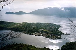
The Banda Islands are a volcanic group of ten small volcanic islands in the Banda Sea, about 140 km (87 mi) south of Seram Island and about 2,000 km (1,243 mi) east of Java, and constitute an administrative district (kecamatan) within the Central Maluku Regency in the Indonesian province of Maluku. The islands rise out of 4-to-6-kilometre deep ocean and have a total land area of approximately 172 square kilometres (66 sq mi). They had a population of 18,544 at the 2010 Census and 20,924 at the 2020 Census. Until the mid-19th century the Banda Islands were the world's only source of the spices nutmeg and mace, produced from the nutmeg tree. The islands are also popular destinations for scuba diving and snorkeling. The main town and administrative centre is Banda Neira, located on the island of the same name.
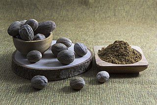
Nutmeg is the seed, or the ground spice derived from that seed, of several tree species of the genus Myristica; fragrant nutmeg or true nutmeg is a dark-leaved evergreen tree cultivated for two spices derived from its fruit: nutmeg, from its seed, and mace, from the seed covering. It is also a commercial source of nutmeg essential oil and nutmeg butter. Indonesia is the main producer of nutmeg and mace, and the true nutmeg tree is native to its islands.

The United East India Company was a chartered company established on 20 March 1602 by the States General of the Netherlands amalgamating existing companies into the first joint-stock company in the world, granting it a 21-year monopoly to carry out trade activities in Asia. Shares in the company could be bought by any resident of the United Provinces and then subsequently bought and sold in open-air secondary markets. It is sometimes considered to have been the first multinational corporation. It was a powerful company, possessing quasi-governmental powers, including the ability to wage war, imprison and execute convicts, negotiate treaties, strike its own coins, and establish colonies.

The Maluku Islands or the Moluccas are an archipelago in the eastern part of Indonesia. Tectonically they are located on the Halmahera Plate within the Molucca Sea Collision Zone. Geographically they are located east of Sulawesi, west of New Guinea, and north and east of Timor. Lying within Wallacea, the Moluccas have been considered as a geographical and cultural intersection of Asia and Oceania.

Jan Pieterszoon Coen was an officer of the Dutch East India Company (VOC) in the early 17th century, holding two terms as governor-general of the Dutch East Indies. He was the founder of Batavia, capital of the Dutch East Indies. Renowned for providing the impulse that set the VOC on the path to dominance in the Dutch East Indies, he was long considered a national hero in the Netherlands. Since the 19th century, his legacy has become controversial due to the brutal violence he employed in order to secure a trade monopoly on nutmeg, mace and clove. During the last stage of the Dutch conquest of the Banda Islands, Coen depopulated the islands to such a degree he massacred about 14.400 people in Banda, about 800 of whom were transferred to Batavia.

Ambon Island is part of the Maluku Islands of Indonesia. The island has an area of 743.37 km2 (287.02 sq mi) and is mountainous, well watered, and fertile. Ambon Island consists of two territories: the city of Ambon to the south and various districts (kecamatan) of the Central Maluku Regency to the north. The main city and seaport is Ambon, which is also the capital of Maluku province, while those districts of Maluku Tengah Regency situated on Ambon Island had a 2020 Census population of 128,069. Ambon has an airport and is home to the Pattimura University and Open University, state universities, and a few private universities, which include Darussalam University and Universitas Kristen Indonesia Maluku (UKIM).

The Kai Islands of Indonesia are a group of islands in the southeastern part of the Maluku Islands, located in the province of Maluku. The Moluccas have been known as the Spice Islands due to regionally specific plants such as nutmeg, mace, and cloves that originally intrigued the European nations of the 16th century.

Run is one of the smallest islands of the Banda Islands, which are a part of the Moluccas, Indonesia. It is located within Banda District (kecamatan) in Central Maluku Regency.

Francisco Serrão was a Portuguese explorer and a possible cousin of Ferdinand Magellan. His 1512 voyage was the first known European sailing east past Malacca through modern Indonesia and the East Indies. He became a confidant of Sultan Bayan Sirrullah, the ruler of Ternate, becoming his personal advisor. He remained in Ternate where he died around the same time Magellan died.

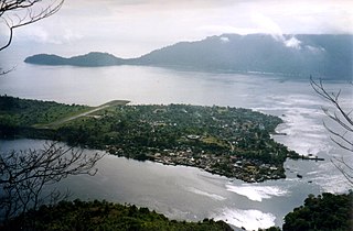
Banda Api is an island in the Banda Islands, Indonesia. It is administered as part of the administrative district (kecamatan) within the Central Maluku Regency in the province of Maluku.

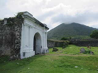
Fort Belgica is a 17th-century fort in Banda Neira, Banda Islands, Maluku Islands, Indonesia; administratively in Central Maluku Regency, Maluku. The fort acted as a fortification system for the islands of Banda which was the only place in the world during that period where nutmeg was produced.

Fort Tolukko is a small fortification on the east coast of Ternate facing Halmahera. It was one of the colonial forts built to control the trade in clove spices, which prior to the eighteenth century were only found in the Maluku Islands. It has been variously occupied by the Portuguese, the native Ternate Sultanate, the Dutch, the British and the Spanish. It was abandoned as a fort in 1864, renovated in 1996, and is now a tourist attraction.
Banda is an Austronesian language of the Central Maluku subgroup. Along with Kei, it is one of the two languages of the Kei Islands in the Indonesian province of Maluku.

The Banda Islands were a governorate of the Dutch East India Company. The governorate comprised Banda Neira, Banda Besar, Pulau Ai, Run, Banda Api, and some smaller islands.
Fort Nassau was the first Dutch fort built on Banda Neira Island, the main island of the Banda Islands, part of Maluku in Indonesia, completed in 1609. Its purpose was to control the trade in nutmeg, which at that time was only grown in the Banda Islands.
Banda Besar, historically also known as Lonthoir, is the largest of the Banda Islands in Indonesia. It is administered as part of Banda District, Central Maluku Regency, Maluku Province.

The archaeology of Indonesia is the study of the archaeology of the archipelagic realm that today forms the nation of Indonesia, stretching from prehistory through almost two millennia of documented history. The ancient Indonesian archipelago was a geographical maritime bridge between the political and cultural centers of Ancient India and Imperial China, and is notable as a part of ancient Maritime Silk Road.

The Dutch conquest of the Banda Islands was a process of military conquest from 1609 to 1621 by the Dutch East India Company of the Banda Islands. The Dutch, having enforced a monopoly on the highly lucrative nutmeg production from the islands, were impatient with Bandanese resistance to Dutch demands that the Bandanese sell only to them. Negotiations collapsed after Bandanese village elders deceived and murdered the Dutch representative Pieter Willemsz. Verhoeff. Under the command of Jan Pieterszoon Coen the Dutch resorted to a forcible conquest of the islands, which became severely depopulated as a result of Coen’s massacres, forced deportations, and the resulting starvation and disease.

The invasion of the Spice Islands was a military invasion by British forces that took place between February and August 1810 on and around the Dutch owned Maluku Islands also known as the Spice Islands in the Dutch East Indies during the Napoleonic wars.

A tifa totobuang is a music ensemble from the Maluku Islands, related to the kulintang orchestra. It consists of a set of a double row of gong chimes known as the totobuang and a set of tifa drums. It can also include a large gong.