
Sabah is a state of Malaysia located on the northern portion of Borneo, in the region of East Malaysia. Sabah has land borders with the Malaysian state of Sarawak to the southwest and Indonesia's North Kalimantan province to the south. The Federal Territory of Labuan is an island just off Sabah's west coast. Sabah shares maritime borders with Vietnam to the west and the Philippines to the north and east. Kota Kinabalu is the state capital and the economic centre of the state, and the seat of the Sabah State government. Other major towns in Sabah include Sandakan and Tawau. The 2020 census recorded a population of 3,418,785 in the state. It has an equatorial climate with tropical rainforests, abundant with animal and plant species. The state has long mountain ranges on the west side which forms part of the Crocker Range National Park. Kinabatangan River, the second longest river in Malaysia runs through Sabah. The highest point of Sabah, Mount Kinabalu is also the highest point of Malaysia. While internationally recognised as Malaysian territory, the Philippines maintains a dormant claim on the eastern portion of Sabah, on the basis that it was historically territory of the Sultanate of Sulu.

East Malaysia, or the Borneo States, also known as Malaysian Borneo, is the part of Malaysia on and near the island of Borneo, the world's third-largest island. East Malaysia comprises the states of Sabah, Sarawak, and the Federal Territory of Labuan. The small independent nation of Brunei comprises two enclaves in Sarawak. To the south and southeast is the Indonesian portion of Borneo, Kalimantan. East Malaysia lies to the east of Peninsular Malaysia, the part of the country on the Malay Peninsula. The two are separated by the South China Sea.
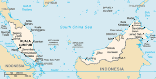
The geography of Malaysia includes both the physical and the human geography of Malaysia, a Southeast Asian country made up of two major landmasses separated by water—Peninsular Malaysia to the West and East Malaysia to the East—and numerous smaller islands that surround those landmasses. Peninsular Malaysia is on the southernmost part of the Malay Peninsula, south of Thailand, north of Singapore and east of the Indonesian island of Sumatra; East Malaysia comprises most of the northern part of Borneo island, and shares land borders with Brunei to the north and Indonesian Borneo to the south.

Labuan, officially the Federal Territory of Labuan, is an island federal territory of Malaysia. Its territory includes Labuan Island and six smaller islands, off the coast of the state of Sabah in East Malaysia. Labuan's capital is Victoria and is best known as an offshore financial centre offering international financial and business services via Labuan IBFC since 1990 as well as being an offshore support hub for deepwater oil and gas activities in the region. It is also a tourist destination for people travelling through Sabah, nearby Bruneians and scuba divers. The name Labuan derives from the Malay word labuhan which means harbour.

Semporna is the capital of the Semporna District in the Tawau Division of Sabah, Malaysia. Its population was estimated to be around 35,301 in 2010.
Malaysia is a country in Southeast Asia. The federal constitutional monarchy consists of 13 states and three federal territories, separated by the South China Sea into two regions: Peninsular Malaysia and Borneo's East Malaysia. Peninsular Malaysia shares a land and maritime border with Thailand and maritime borders with Singapore, Vietnam, and Indonesia. East Malaysia shares land and maritime borders with Brunei and Indonesia, as well as a maritime border with the Philippines and Vietnam. Kuala Lumpur is the national capital, the country's largest city, and the seat of the legislative branch of the federal government. Putrajaya is the country's administrative centre, which represents the seat of both the executive branch and the judicial branch of the federal government. With a population of over 33 million, The country is the world's 43rd-most populous country. The southernmost point of continental Eurasia is Tanjung Piai. Located in the tropics, the country is one of 17 megadiverse countries and home to numerous endemic species.

Perai is an urban settlement in the city of Seberang Perai, Penang, Malaysia. It lies at the southern bank of the Perai River and borders Butterworth to the north. Perai gave its name to the city of Seberang Perai, the mainland half of the State of Penang.

Seberang Jaya is a suburb in the city of Seberang Perai, Penang, Malaysia. Located at the southern bank of the Perai River and east of Perai proper, the area was developed in the 1970s. Since then, Seberang Jaya has evolved into a booming area, with various commercial and retail developments.

Gaya Island is a sizeable Malaysian island of 1,465 ha, just 10 minutes off Kota Kinabalu, Sabah and forms part of the Tunku Abdul Rahman National Park. Gaya Island derived its name from the Bajau word "Gayo" which means big and occupies an area of 15 km2 with an elevation of up to 300 metres. Several ridges rise more than 600 feet, peaking at 1,000 feet, along the backbone of Gaya Island.

Balambangan Island is an island in Kudat Division, Sabah, Malaysia. It is located off the northern tip of Borneo and is situated just about 3 kilometres west of Banggi Island. It is now part of the Tun Mustapha Marine Park.
Malawali is an island in the state of Sabah, Malaysia located in the Sulu Sea. It is located within the Kudat Division, and sits nearby the islands of Banggi and Balambangan. The island is surrounded by coral reefs and is one of the popular diving spot on the north-east coast of Sabah.
Bruit Island is an island in Daro District, Mukah Division, Sarawak, Malaysia. It is located in the Rejang Delta, 150 km northwest of Kuching. With a population of around 9,342 and an area of 417 square kilometres, it is the second largest island in Malaysia after Banggi Island.

The Sama–Bajaw languages are a well-established group of languages spoken by the Sama-Bajau peoples of the Philippines, Indonesia and Malaysia.
The Mantanani Islands form a small group of three islands off the north-west coast of the state of Sabah, Malaysia, opposite the town of Kota Belud, in northern Borneo. The largest island is Mantanani Besar; the other two are Mantanani Kecil and Lungisan. It is a popular site for recreational diving and is known for its dugongs.
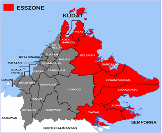
The Eastern Sabah Security Zone (ESSZONE) is a security zone in the Malaysian state of Sabah that was launched by Malaysian Prime Minister Najib Razak on 25 March 2013 following persistent attacks by pirates and militants from the southern Philippines that occurred in the eastern part of Sabah especially after the 2013 Lahad Datu standoff. It includes the districts of Kudat, Kota Marudu, Pitas, Beluran, Sandakan, Kinabatangan, Lahad Datu, Kunak, Semporna and Tawau, which is neighbouring to the Philippines.

Tigabu Island is a Malaysian island located in the Sulu Sea on the state of Sabah.
North Guhuan Island is a Malaysian island located in the Sulu Sea near Banggi Island on the state of Sabah. It is one of the extreme points of Malaysia.
Balak Island is an island located near Banggi Island in the Kudat Division on Sabah, Malaysia.
Tun Mustapha Marine Park is a marine park located off the north coast of the state of Sabah, Malaysia. It comprises an area of 898,762.76 hectares with more than 50 islands and islets located across Kudat, Pitas and Kota Marudu districts; making it the largest gazetted marine park in the country.

