Battle of San Buenaventura

Last updated
Mission San Buenaventura, site of the battle (photo c. 1866 from the Museum of Ventura County) Mission San Buenaventura (1866).png
Mission San Buenaventura, site of the battle (photo c. 1866 from the Museum of Ventura County)

The Battle of San Buenaventura was fought on March 27 and March 28, 1838, between forces representing competing claims to the governorship of California, then a Mexican territory. The opposing forces consisted of supporters of Juan Bautista Alvarado based in Northern California and supporters of Carlos Antonio Carrillo from Southern California. The major action consisted of a cannon siege on the Carrillo loyalists who were encamped at the Mission San Buenaventura in Ventura, California. The Alvarado forces won the battle, as the Carrillo forces fled from the Mission under cover of darkness following the first day of the battle. Most of the Carillo forces were captured the following day at Saticoy, California. One person was killed in the battle, an Alvarado loyalist who was shot by a rifleman stationed in the Mission's bell tower.

Contents

Prelude to battle

Juan Bautista Alvarado JuanBautistaAlvarado.jpg
Juan Bautista Alvarado
Carlos Antonio Carrillo Carlos Antonio Carillo.jpg
Carlos Antonio Carrillo

The battle was fought during the 25-year period (1821-1846) when the modern State of California was a Mexican territory. [1]

Juan Bautista Alvarado was a native Californian who led a movement for the independence of California from 1836 to 1837. He negotiated an agreement with the Mexican government that provided for an end to the independence movement and his recognition as the Governor of California. During the independence struggle led by Alvarado, the Mexican government appointed Carlos Antonio Carrillo, another native Californian and owner of the 8,881-acre Rancho Sespe in Ventura County, as the provisional governor. [2] A schism developed over which of the men was the legitimate governor. The schism widened when Carrillo announced that he was moving the territorial capital to Los Angeles and also moving the custom house from Monterey to San Diego. The border line of the schism was between Santa Barbara and points north which aligned with Alvarado and Ventura and points south which aligned with Carrillo. [3]

In December 1837, a formal ceremony was held in Los Angeles inaugurating Carrillo as governor. [4] On January 3, 1838, Carrillo issued a proclamation declaring the ports of Monterey and San Francisco closed until such time as the north submitted to the new government in Los Angeles. Carrillo also sent his brother to Mexico seeking 200 soldiers to aid in establishing his authority. [5] During January and February 1838, Alvarado and Carrillo exchanged letters seeking to avoid armed conflict. [6]

In early March, Carrillo received an inaccurate report that Alvarado had sent an army south. To halt any invasion from the north, Carrillo sent an armed force to San Buenaventura under the command of Captain Juan Castañeda. Castañeda arrived in San Buenaventura on approximately March 12 and was then ordered to attack Santa Barbara before it could be reinforced from the north. [7] Castañeda advanced with over 100 men to a location within sight of the Presidio of Santa Barbara. The commander of the Presidio refused to surrender, and Castañeda disobeyed the order to attack and instead retreated back to San Buenaventura. [8]

On learning that Carrillo had sent an armed force to San Buenaventura, Alvarado decided to launch a surprise attack on Carrillo’s forces. [9] Alvarado gathered soldiers from the north and placed them under the command of General José Castro, Castro and his soldiers marched south where they united with the forces already stationed at the Santa Barbara Presidio. [10] [11]

The battle

The unguarded Rincon

Castro’s force, totaling approximately 100 men and equipped with three cannons, advanced south from Santa Barbara. To reach San Buenaventura, Castro had to advance through the Rincon Pass, a narrow route between the mountains and the sea that became unpassable at high tide. In his account of the battle, local historian Richard Senate wrote that the Californians of that era believed that "whoever held the Rincon Pass could hold it successfully against any enemy." [12] To Castro's surprise, the Rincon was "unguarded, not even a sentinel being stationed there." [13] Accordingly, Castro was able to advance through the Rincon both unopposed and undetected. [13] [14]

"Do as you please"

Castro's forces arrived in San Buenaventura and surrounded the Mission, catching Castañeda's forces by surprise. [15] On the morning of March 27, Castro sent a note to Castañeda, giving him one hour to evacuate the Mission in exchange for a promise to safeguard life and property. Castañeda replied that he would only comply if the evacuation were made "with all the honors of war." Castro declined to make the concession, and Castañeda refused to surrender. [16] Castro sent a final note threatening to open fire at once, and Castañeda sent his response: "Do as you please." [16]

The siege

Upon receiving Castañeda's final note, Castro ordered his forces to fire their cannons at the Mission. Castro placed two cannons on the shore-side of the Mission, and a third cannon opened fire from an elevation to the back of the mission. [17] According to a 1926 account written by historian Sol N. Sheridan, Castro's forces seized and held a "small fort at the site of the Hill schoolhouse." [18] [lower-alpha 1] Castro also cut off the supply of water from the San Buenaventura Mission Aqueduct, leaving Castañeda's men to drink the mission's wine. [17] [3]

During the siege, the Mission's thick stone and adobe walls protected Castañeda’s forces, and there is no record of any losses among Castañeda's men. [19] [13] Early in the battle, one of Castro’s men, Aquilino Ramirez, was killed by a shot from a rifleman stationed in the Mission's church tower. [17] [20] Ramirez was a father of seven from Santa Barbara, and his death led his comrades-in-arms to direct a furious cannonade at the church. [21]

Castro wrote to Alvarado following the battle, describing "two days of continuous firing". [16] Historian Hubert Howe Bancroft, in his "History of California" questioned the accuracy of Castro’s account, as Castañeda's forces had escaped during the night after the first day of the siege. Bancroft wrote:

The "continuous firing of two days" was perhaps continuous only with considerable intervals between the volleys, and it could not have continued into the second day for a longer time than was necessary to make known the flight of the garrison during the night." [22]

Other historians have also questioned the ferocity of the battle. Sol N. Sheridan, in his "History of Ventura County", wrote: "The whole affair resembled rather a sham battle, than the real thing." [18] The Los Angeles Times in 1998 described it as a "quirky skirmish . . . that emptied the mission of wine, and left its adobe walls pockmarked by cannon fire." [3]

Castañeda's escape

On the night of March 27, Castañeda's forces escaped under cover of night from the Mission and, their horses having been seized by Castro's men, marched on foot toward Los Angeles. [16] Castro sent two companies in pursuit – a company of mounted infantry commanded by Captain Villa and a cavalry company of lancers commanded by Captain Cota. Castro remained in San Buenaventura with the remaining forces, writing to Alvarado that he intended to safeguard their conquest of a place that would be "very advantageous for us." [16]

Capture of Castañeda’s forces

Andres Pico, captured in the battle Andres Pico c1850.jpg
Andrés Pico, captured in the battle

On March 28, Castro's troops, riding on horseback, quickly caught up with Castañeda’s men near Saticoy, a short distance from Ventura. [23] They captured 70 of Castañeda’s men along with "50 muskets and other arms." The soldiers were released, but Castañeda and his officers were arrested and taken to Santa Barbara. [17]

Castro's forces also captured several prominent Carrillo supporters who were found hiding in the Mission. These men, including Andrés Pico (who later negotiated the Treaty of Cahuenga), Luis Arenas (mayor of Los Angeles from 1838 to 1839), and Ygnacio Palomares (owner of the lands encompassing the modern cities of Pomona, San Dimas, Azusa, Covina, Glendora, and Claremont), were taken prisoner and sent north with Castañeda and his officers. [23]

Aftermath

Several of Castañeda's soldiers were not captured and continued toward Los Angeles, meeting up with Pio Pico who was leading a small contingent that had intended to reinforce Castañeda. Pico carried news to Los Angeles of the defeat at San Buenaventura. [24] Carrillo retreated from Los Angeles to San Diego. Castro’s forces continued southward to Los Angeles without opposition. [25] Carrillo assembled a small force in San Diego, but Carrillo surrendered after what has been described as a "mock battle" at Las Flores, California. [26]

Alvarado continued as Governor until 1842, and Carrillo "was paroled" by Alvarado. [27]

For years after the battle, damage caused by Castro's cannonade was still visible on the Mission's exterior walls. During repairs conducted in 1874, a cannonball was extracted from an exterior wall. [17]

In a 1975 archaeological dig at the Mission, six cannon balls were recovered. Their size, about two inches in diameter and weighing one pound, indicate that at least one of the cannons was a small ship gun. [21] One of the cannonballs and two black pieces of grapeshot from the battle are displayed at the Albinger Archaeological Museum in Ventura. The Los Angeles Times in 1992 wrote that the pieces displayed at the Albinger were "are all that is left of the 1838 battle at the San Buenaventura Mission." [28]

Notes

  1. There was no "fort" at the site of the old Hill schoolhouse. Sheridan's reference likely refers to an old adobe structure overlooking the Mission known as the "House of the Angel".

Related Research Articles

<span class="mw-page-title-main">Mission San Buenaventura</span> 18th-century Spanish mission in California

Mission San Buenaventura, formally known as the Mission Basilica of San Buenaventura, is a Catholic parish and basilica in the Archdiocese of Los Angeles. The parish church in the city of Ventura, California, United States, is a Spanish mission founded by the Order of Friars Minor. Founded on March 31, 1782, it was the ninth Spanish mission established in Alta California and the last to be established by the head of the Franciscan missions in California, Junípero Serra. Designated a California Historical Landmark, the mission is one of many locally designated landmarks in downtown Ventura.

<span class="mw-page-title-main">Ventura County, California</span> County in California, United States

Ventura County is a county located in the southern part of the U.S. state of California. As of the 2020 census, the population was 843,843. The largest city is Oxnard, and the county seat is the city of Ventura.

<span class="mw-page-title-main">Ventura, California</span> City in California, United States

Ventura, officially named San Buenaventura, is a city in and the county seat of Ventura County, California, United States. It is a coastal city located northwest of Los Angeles. The population was 110,763 at the 2020 census. Ventura is a popular tourist destination, owing to its historic landmarks, beaches, and resorts.

<span class="mw-page-title-main">California Republic</span> Unrecognized breakaway state from Mexico, 1846

The California Republic, or Bear Flag Republic, was an unrecognized breakaway state from Mexico, that for 25 days in 1846 militarily controlled an area north of San Francisco, in and around what is now Sonoma County in California.

<span class="mw-page-title-main">Battle of San Pasqual</span> Mexican-American War battle

The Battle of San Pasqual, also spelled San Pascual, was a military encounter that occurred during the Mexican–American War in what is now the San Pasqual Valley community of the city of San Diego, California. The series of military skirmishes ended with both sides claiming victory, and the victor of the battle is still debated. On December 6 and 7, 1846, General Stephen W. Kearny's US Army of the West, along with a small detachment of the California Battalion led by a Marine Lieutenant, engaged a small contingent of Californios and their Presidial Lancers Los Galgos, led by Major Andrés Pico. After U.S. reinforcements arrived, Kearny's troops were able to reach San Diego.

The Battle of Dominguez Rancho, or the Battle of the Old Woman's Gun, was a military engagement of the Mexican–American War that took place on October 8–9, 1846, within Manuel Dominguez's 75,000 acre Rancho San Pedro. Captain José Antonio Carrillo, leading fifty California troops, successfully held off an invasion of Pueblo de Los Angeles by some 300 United States Marines, capturing for the first time in the few instances of U.S. history the U.S. Colors upon the battlefield, while under the command of US Navy Captain William Mervine, who was attempting to recapture the town after the Siege of Los Angeles. By strategically running horses across the dusty Dominguez Hills, while transporting their single small cannon to various sites, Carrillo and his troops convinced the Americans they had encountered a large enemy force. Faced with heavy casualties and the superior fighting skills displayed by the Californios, the remaining Marines were forced to retreat to their ships docked in San Pedro Bay.

<span class="mw-page-title-main">Juan Bautista Alvarado</span> Californio politician

Juan Bautista Valentín Alvarado y Vallejo usually known as Juan Bautista Alvarado, was a Californio politician that served as Governor of Alta California from 1837 to 1842. Prior to his term as governor, Alvarado briefly led a movement for independence of Alta California from 1836 to 1837, in which he successfully deposed interim governor Nicolás Gutiérrez, declared independence, and created a new flag and constitution, before negotiating an agreement with the Mexican government resulting in his recognition as governor and the end of the independence movement.

<span class="mw-page-title-main">Olivas Adobe</span> Historic house in California, United States

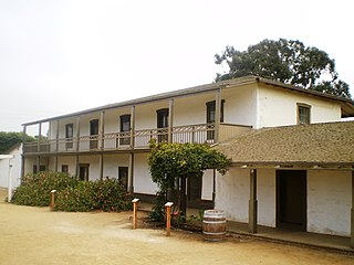
The Olivas Adobe in Ventura, California is an adobe structure built in 1837 by Raymundo Olivas on the north bank of the Santa Clara River about a mile from the estuary where it flows into the Santa Barbara Channel.

José María de Echeandía (?–1871) was the Mexican governor of Alta California from 1825 to 1831 and again from 1832 to 1833. He was the only governor of California that lived in San Diego.

General José María Flores was a Captain in the Mexican Army and was a member of la otra banda. He was appointed Governor and Comandante Generalpro tem of Alta California from November 1846 to January 1847, and defended California against the Americans during the Mexican–American War.

<span class="mw-page-title-main">José Antonio Carrillo</span> Californio politician (1796–1862)

Captain José Antonio Ezequiel Carrillo (1796–1862) was a Californio politician, ranchero, and signer of the California Constitution in 1849. He served three terms as Alcalde of Los Angeles (mayor).

Salomón María Simeon Pico was a Californio, a cousin of former governor Pío Pico, who led a bandit band in the early years following the Mexican–American War in the counties of the central coast of California. Pico was considered by some Californios to be a patriot who opposed the American conquest of Alta California and its subsequent incorporation into the United States. He was hated for his banditry by the newly arrived Americans but protected by some Californios as a defender of his people.

The Rincon Parkway is a portion of California State Route 1 along the north coast of Ventura County, California. This narrow coastal area north of the city of Ventura and south of the Santa Barbara County line is commonly referred to as The Rincon. The automobile route along this portion of coastline opened up in 1913 as the Rincon Causeway or the Rincon Sea Level Road as the first driveable coastal route for motorists traveling between San Francisco and Los Angeles, California. The access road alongside the railroad bed, that cut through the area in 1886, provided the basis for building the Rincon Sea Level Road.

<span class="mw-page-title-main">Rancho Ex-Mission San Buenaventura</span> Mexican land grant in Ventura County, California

Rancho Ex-Mission San Buenaventura was a 48,823-acre (197.58 km2) Mexican land grant in present-day Ventura County, California given in 1846 by Governor Pío Pico to José de Arnaz. The grant derives its name from the secularized Mission San Buenaventura, and was called ex-Mission because of a division made of the lands held in the name of the Mission — the church retaining the grounds immediately around, and all of the lands outside of this are called ex-Mission lands. The grant extended east from present day Ventura, excluding the Rancho San Miguel (Olivas) lands, inland up the Santa Clara River to Santa Paula, between the north bank of the River and Sulphur Mountain.

<span class="mw-page-title-main">Rancho Cañada Larga o Verde</span> Mexican land grant in Ventura County, California

Rancho Cañada Larga o Verde was a 6,659-acre (26.95 km2) Mexican land grant in present-day Ventura County, California given in 1841 by Governor Juan B. Alvarado to Joaquina Alvarado. The grant extended along Sulphur Canyon Creek, east of the Ventura River, between Ventura and Ojai. To the west, across the Ventura River was Rancho Cañada de San Miguelito; to the north Rancho Ojai; and to the south and east Rancho Ex-Mission San Buenaventura.

<span class="mw-page-title-main">Rancho Santa Ana</span> Mexican land grant in Ventura County, California

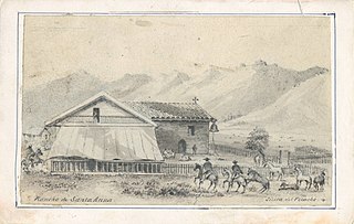
Rancho Santa Ana was a 21,522-acre (87.10 km2) Mexican land grant in present day Ventura County, California given in 1837 by Governor Juan Alvarado to Crisogono Ayala and Cosme Vanegas. Rancho Santa Ana was located inland in the Ventura River Valley on the west side of the Ventura River across from Rancho Ojai which was granted in the same year. Rancho Santa Ana encompassed present day Lake Casitas and Oak View.

<span class="mw-page-title-main">Joseph John Chapman</span> Early California settler (1784–1849)

Joseph John "Jose Juan" Chapman (1784–1849) was an American merchant sailor, then a crew member under the privateer Hippolyte Bouchard, then one of the earliest English-speaking settlers and builders of Mexican Alta California. Chapman was one of the first known American-born permanent residents of Alta California. The scanty and inconsistent historical record makes it difficult to be sure of many details of Chapman's life, but he was a valued member of several early southern California settlements, and interacted with a number of historical characters.

<span class="mw-page-title-main">Serra Cross</span> Landmark on a hill in Ventura, California

The Serra Cross, sometimes also known as the Cross on the Hill or the Grant Park Cross, is a Christian cross on a hill known as "La Loma de la Cruz" in Ventura, California. The site is in Serra Cross Park, a one-acre parcel within the larger Grant Park that overlooks downtown Ventura, the Santa Barbara Channel, and Anacapa and Santa Cruz Islands.

<span class="mw-page-title-main">Santa Gertrudis Asistencia</span>

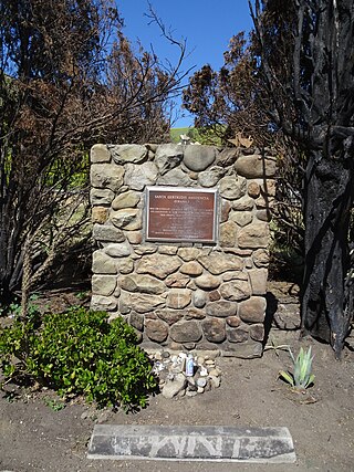
The Santa Gertrudis Asistencia, also known as the Santa Gertrudis Chapel, was an asistencia ("sub-mission") to the Mission San Buenaventura, part of the system of Spanish missions in Las Californias—Alta California. Built at an unknown date between 1792 and 1809, it was located approximately five miles from the main mission, inland and upstream along the Ventura River. The site was buried in 1968 by the construction of California State Route 33. Prior to the freeway's construction, archaeologists excavated and studied the site. A number of foundation stones were moved and used to create the Santa Gertrudis Asistencia Monument which was designated in 1970 as Ventura County Historic Landmark No. 11.

<span class="mw-page-title-main">Carrillo family of California</span>

The Carrillo family is a prominent Californio family of Southern California. Members of the family held extensive rancho grants and numerous important political positions, including Governor of Alta California, Mayor of Los Angeles, Mayor of Santa Barbara, Mayor of Santa Monica, and a signer of the Californian Constitution.

References

  1. Michael Gonzalez (2009). "War and the Making of History: The Case of Mexican California, 1821—1846". California History. 86 (2): 5–68. doi:10.2307/40495206. JSTOR   40495206.
  2. Hubert Howe Bancroft (1886). History of California, Volume III (1825-1840). The History Company. p. 534.
  3. 1 2 3 Jane Hulse (April 16, 1998). "Historical Footnote: Downtown walking tour to recount obscure Battle of San Buenaventura". Los Angeles Times. p. Weekend magazine, p. 7 via Newspapers.com.
  4. Bancroft, History of California, p. 539.
  5. Bancroft, History Company, p. 545.
  6. Bancroft, History Company, pp. 546-547.
  7. Bancroft, History of California, Vol. III, p. 549.
  8. Bancroft, History of California, Vol. III, p. 550.
  9. Bancroft, History of California, Vol. III, p. 551.
  10. Bancroft, History of California, Vol. III, p. 552.
  11. Senate, pp. 2-3.
  12. Richard Senate (1997). The Battles at San Buenaventura. Charon Press. p. 3.
  13. 1 2 3 Sol N. Sheridan (1926). History of Ventura County, California, Volume 1. The S.J. Clarke Publishing Co. p. 81.
  14. Bancroft, History of California, pp. 552-553.
  15. Bancroft, History of California, Vol. III, pp. 552-553.
  16. 1 2 3 4 5 Bancroft, History of California, Vol. III, p. 553.
  17. 1 2 3 4 5 Bancroft, History of California, Vol. III, p. 554.
  18. 1 2 Sheridan, History of Ventura County, p. 81.
  19. Senate, p. 3.
  20. Bancroft notes that an account by Jesus Pico identified the fatality as a man with the surname Olivas.
  21. 1 2 Senate, p. 4.
  22. Bancroft, History of California, Vol. III, pp. 554-555.
  23. 1 2 Bancroft, History of California, Vol. III, p. 555.
  24. Bancroft, History of California, Vol. III, p. 556.
  25. Bancroft, History of California, Vol. III, pp. 556-558.
  26. Senate, p. 6.
  27. Sheridan, History of Ventura County, p. 82.
  28. Caitlin Rother (June 29, 1992). "History Museum to Reclaim Albinger". Los Angeles Times.