Battlefield archaeology is a sub-discipline of archaeology which studies the material remains and topography of a battlefield to understand a conflict. [1] Archaeological battlefields consist of skirmishes, sieges, camps, and training sites. The study of the relationships and contexts of the material by-products of war give an alternate account to the version recorded in a history book, poem, or witness account, which may be constructed though bias, or may present only a limited perspective of the events. Examination of these locations gives insight to what tactics were being used, weapon modifications, and battle formations. [2] It is not considered distinct from Military archaeology or Recceology (i.e., the recovery of surface finds and non-invasive site surveying).
Whilst the battlefield is a contemporary concept, the archaeology of battlefields incorporates the study of both ancient and modern military technologies, features and conflicts. It may also incorporate events such as civil unrest, including public demonstrations and riots. The discipline, therefore, applies the approaches and techniques of archaeology to military and civil conflict. Conflicts in the twentieth century in particular have been characterised by wars of ethnicity, nationality and identity, where civilians and civilian environments (i.e., domestic buildings, urban centres) have become involved in warfare, and are often inseparable from it. [3] This is also known as 'Total War', understood by the engagement of entire populations and economies within the sphere of warfare. The archaeology of contemporary conflict, therefore, is a 'total' project, considering the impact of conflict and modern weapons systems on civilian as well as military targets.
Common artifacts would be cannons and firearm fragments from a Revolutionary War battle. Data cannot be counted as evidence until a pattern is found. An example would be a unique looking bullet. If the artifact doesn't match any other data collected, the piece more than likely wasn't part of the conflict being studied. [2] Information is found through historical references, regional archaeologists, and previous studies. [1]
Prosecution of battlefield thieves rarely occurs. Most penalties do not include jail time but usually involve a confiscation of items or metal detectors. Laws have been passed to deter criminals, but looting still occurs. The National Historic Preservation Act (NHPA) was one such act, but lacks penalties needed to deter crime. [4]
This section needs expansion. You can help by adding to it. (March 2017) |
Battlefield archaeology was first used in England at the site of the battle of Naseby. Between 2006 and 2008 the Council for British Archaeology conducted a resource assessment for English Heritage, creating a database of more than 200 battlefields in England. According to the report, "battlefields [in England] older than 1066 are at present almost impossible to locate". By 2012 there was no comparable database for Europe, though 56 battlefields had been ascertained for Scotland. [5] The Register of Historic Battlefields, now maintained by Historic England, was founded in 1995. [6]
Earthwork surveys are the search for manmade modifications to the environment or ground such as trenches or holes. [2] Depending on the time period of the battlefield being studied, earthwork surveys will exhibit varying degrees of success. Before modern history such as medieval history, open battlefields were the primary battlegrounds. Within the last two centuries, trench warfare has become increasingly popular allowing earthwork surveys to become far more useful. These time dependent characteristics on battlefields can typologically identify and date earthworks. This will help remove any confusion such as placing trench warfare with Egyptian warfare tactics.
Battlefield archaeologists utilize a variety of geophysical instruments. These instruments have the ability to identify the irregularity (artifact, bone, wall) and omit any other background material such as dirt or naturally occurring elements.
The metal detector is the most common instrument used within battlefield archaeology. The location of fragments on metal are located by using an induced magnetic field within a certain proximity to the head of the detector. [2] The quality of the instrument varies allowing for a range of depth quality. A metal detector generally works to a maximum depth of between 20–30cm deep for smaller objects. Battlefield archaeologists are most successful with metal detectors when using them in large groups. Novice users of metal detectors can easily miss or record misleading data.
A fluxgate gradiometer records anomalies in the Earth’s magnetic field across a specific area. These detectors are especially useful when detecting ferrous items. They detect ferrous spikes when a piece of ferrous metal is close to the instrument. [2] These instruments are most useful the more recent the site’s artifacts have existed. Since iron has a natural tendency to change over time, fluxgate gradiometers have a tendency to fail in identifying locations where iron is present. These devices are very successful when locating mass graves on battlefields. Depending on the strength of the magnetic anomaly, a fluxgate gradiometer can have various degrees of success. They generally work at a depth of around 50cm.
An electrical earth resistance meter records differences in the electrical conductivity or water content within soil. These instruments are very effective at depths of less than 50cm deep. Electrical Earth resistance meters are very successful at located recent graves because recent grave fills often exhibit different moisture content compared to surroundings. [2]
Ground-penetrating radar sends out electromagnetic radiation pulses to detect and then reflect signals from subsurface structures. The electromagnetic conductivity can drastically affect the limit of the device although they are usually effective up to several meters deep. In order to be effective, the anomaly being investigated needs to be distinct from the background material.
Field walking surveys are done by walking across a field looking for artifacts on the surface. A grid system is employed so as to mark the specific location an artifact was found and to map out the remaining artifacts in relation to each other. This process requires little expertise and minimal equipment as long as grid mapping is very effective and accurate. Depending on the circumstances, the artifacts are either collected or analyzed on site so their historical context is placid. [2]
Desk-top assessments are performed by searching through text based documents pertaining to the site in question. These can include maps, photographs, primary sources, and secondary sources. The issue with desk-top assessments is that depending on the historical context, certain international conflicts can vary in accuracy. [2]
The First World War exhibited a conflict that mobilised large numbers of soldiers and a sophisticated and diverse array of material culture. [7] Battlefield Archaeology in this arena has dealt with the battlefields of conflict, where human action and technology shaped the landscape into recognisable and extensive features. It also concerns the study of material culture associated with individuals: including 'trench art', such as engraved shells and the personal belongings of private soldiers, officers and civilian staff.
Excavations and survey work have also been conducted in southern Jordan, [8] known for the conflict during World War I between Ottoman forces, Bedouin tribes-people and British forces commanded by T.E. Lawrence (the 'Great Arab Revolt'). The project looked for the militarised footprint of the conflict, basing its conclusions on trench systems, army camps and the refuse of forces (small-finds including coins, bullets and other military gear).
Excavations on the Western Front often occur for humanitarian reasons, namely the recovery and identification of human remains and the disposal of unexploded ordnance. The unique conditions of Western Front excavations often pose a threat for archaeological excavations. For example, during the first five hours of the Kaiserschlacht ('German spring offensive'), over one million shells were fired by the Germans into the Allies' lines across the entire 150-mile front. [9] The million shells fired during the beginning of the Spring Offensive are only a small sample of the total used during the war. Most of the shell casings were dumped on the battlefields and a considerable number of shells did not detonate upon impact. Archaeologists conducting excavations at World War I sites are often at risk not just from the unexploded ordnance but from the environmental pollution caused by the deterioration of ordnance, shell and bullet casings, and various other forms of battlefield debris. A study conducted at the Ypres battlefield in 2008 concluded that the highest level of copper contamination of the soil was over 200mg/kg, which was higher than the background threshold of 17mg/kg. [10] The large area in France, where the levels of heavy metals from battlefield debris can negatively impact the health of flora and fauna is labeled by the French government as Zone Rouge (Red Zone). The French Government created Département du Déminage for the purpose of collecting and detonating unexploded ordnance in the Red Zone.
The majority of artillery shells recovered during archaeological excavations or by demining operations are from World War I. This is due to a revolution in shell design that occurred between the First and Second World Wars. In World War I, artillery shells were designed to detonate upon impact. Many times, the detonator would not activate, resulting in the large number of duds. [11] By the time of the Second World War, the detonator for artillery shells was hooked up to a timer. The intention was for the shell to explode over the enemy, raining shrapnel on them. [12]
Archaeological excavations on the Western Front (World War I) have also helped to identify a unique soil condition that is only found in the context of battlefield archaeology. This unique soil condition is known as bombturbation. Intense artillery barrages, and airstrikes cause large amounts of deforestation. Additionally, bombardment creates large craters and mixes the soil layers together in unique ways. [13] As a result, methods of stratigraphic analysis must take into account this unique phenomenon when analyzing a site related to World War I.
A noteworthy burial site contains the remains of thirty-one British soldiers at Le Pont de Jure. It is thought that these soldiers died in April 1917 during successful British assaults on the German trenches in the area. [14] The burials for the soldiers were carefully prepared. The distance between each body was roughly equal, showing that time was taken to carefully measure the locations of each. The bodies were buried with their arms placed across their chests. Two bodies show evidence of having been victims of artillery or other high explosives, with only one arm, one leg, and half a skull between the two of them. The two victims were also buried alongside two pairs of empty boots. When these soldiers died, these may have been the only recognizable body parts lefts to bury. [15]
Mass grave sites sometimes reuses preexisting trenches or artillery craters. One example would be the German mass burials at Gavrelle. It contained twelve German soldiers of the 152nd Infantry Regiment of the 48th division. [16]
A metal detector is an instrument that detects the nearby presence of metal. Metal detectors are useful for finding metal objects on the surface, underground, and under water. The unit itself, consists of a control box, and an adjustable shaft, which holds a pickup coil, which can vary in shape and size. If the pickup coil comes near a piece of metal, the control box will register its presence by a changing tone, a flashing light, and or by a needle moving on an indicator. Usually the device gives some indication of distance; the closer the metal is, the higher the tone in the earphone or the higher the needle goes. Another common type are stationary "walk through" metal detectors used at access points in prisons, courthouses, airports and psychiatric hospitals to detect concealed metal weapons on a person's body.
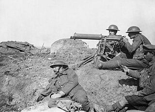
Trench warfare is the type of land warfare using occupied lines largely comprising military trenches, in which troops are well-protected from the enemy's small arms fire and are substantially sheltered from artillery. It became archetypically associated with World War I (1914–1918), when the Race to the Sea rapidly expanded trench use on the Western Front starting in September 1914.
A fortification is a military construction designed for the defense of territories in warfare, and is used to establish rule in a region during peacetime. The term is derived from Latin fortis ("strong") and facere.
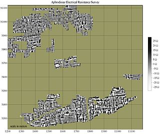
In archaeology, geophysical survey is ground-based physical sensing techniques used for archaeological imaging or mapping. Remote sensing and marine surveys are also used in archaeology, but are generally considered separate disciplines. Other terms, such as "geophysical prospection" and "archaeological geophysics" are generally synonymous.
Technology during World War I (1914–1918) reflected a trend toward industrialism and the application of mass-production methods to weapons and to the technology of warfare in general. This trend began at least fifty years prior to World War I during the American Civil War of 1861–1865, and continued through many smaller conflicts in which soldiers and strategists tested new weapons.
A defensive fighting position (DFP) is a type of earthwork constructed in a military context, generally large enough to accommodate anything from one soldier to a fire team.
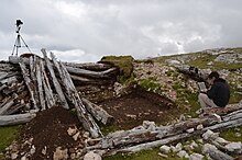
In archaeology, survey or field survey is a type of field research by which archaeologists search for archaeological sites and collect information about the location, distribution and organization of past human cultures across a large area. Archaeologists conduct surveys to search for particular archaeological sites or kinds of sites, to detect patterns in the distribution of material culture over regions, to make generalizations or test hypotheses about past cultures, and to assess the risks that development projects will have adverse impacts on archaeological heritage. The surveys may be: (a) intrusive or non-intrusive, depending on the needs of the survey team and; (b) extensive or intensive, depending on the types of research questions being asked of the landscape in question. Surveys can be a practical way to decide whether or not to carry out an excavation, but may also be ends in themselves, as they produce important information about past human activities in a regional context.
The St. Julien Memorial, also known as The Brooding Soldier, is a Canadian war memorial and small commemorative park located in the village of Saint-Julien, Langemark, Belgium. The memorial commemorates the Canadian First Division's participation in the Second Battle of Ypres of World War I which included fighting in the face of the first poison gas attacks along the Western Front. The memorial was designed by World War I veteran and architect, Lieutenant Frederick Chapman Clemesha, and was selected following a design competition organized by the Canadian Battlefields Memorials Commission in 1920.
The Ypres Salient, around Ypres, in Belgium, was the scene of several battles and a major part of the Western Front during World War I.
Industrial warfare is a period in the history of warfare ranging roughly from the early 19th century and the start of the Industrial Revolution to the beginning of the Atomic Age, which saw the rise of nation-states, capable of creating and equipping large armies, navies, and air forces, through the process of industrialization.
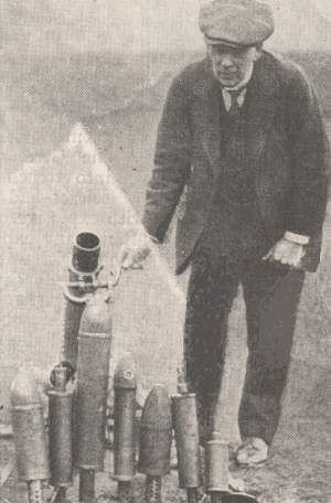
The Stokes mortar was a British trench mortar designed by Sir Wilfred Stokes KBE that was issued to the British and U.S. armies, as well as the Portuguese Expeditionary Corps, during the latter half of the First World War. The 3-inch trench mortar is a smooth-bore, muzzle-loading weapon for high angles of fire. Although it is called a 3-inch mortar, its bore is actually 3.2 inches or 81 mm.
Peter Arthur Barton is a British military historian, author and filmmaker specialising in trench warfare during World War I. He has published extensively on military mining and aspects of battlefield archaeology on the Western Front, and led archaeological excavations that have been featured in several Time Team episodes. His work has led to the rediscovery of many tunnels, wartime panoramas and mass graves of soldiers.
The artillery of World War I, which led to trench warfare, was an important factor in the war, influenced its tactics, operations, and incorporated strategies that were used by the belligerents to break the stalemate at the front. World War I raised artillery to a new level of importance on the battlefield.
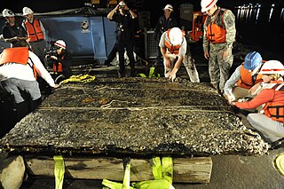
Conflict archaeology is a sub-discipline within archaeology focused on intergroup and intragroup conflict. Closely linked to battlefield archaeology and Military Sites Archaeology, conflict archaeology is developing as an umbrella sub-discipline that encompasses these others, allowing for greater epistemological elasticity than other terms. Modern conflict archaeology deals with technological, social, cultural, psychological aspects of present conflicts. Unlike battlefield archaeology, modern conflict archaeology delves deeper into the anthropological study of the conflicts rather than the physical manifestations of the battles. As stated by Nicholas Saunders in his book entitled Beyond the Dead Horizon, "These complexities are generated partly by nature of modern wars/conflicts of industrialized intensity and they incorporate political and nationalistic motivations and notions of ethnicity and identity."
Archaeology or archeology is the study of human activity through the recovery and analysis of material culture. The archaeological record consists of artifacts, architecture, biofacts or ecofacts, sites, and cultural landscapes. Archaeology can be considered both a social science and a branch of the humanities. It is usually considered an independent academic discipline, but may also be classified as part of anthropology, history or geography.
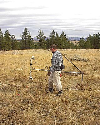
Magnetic surveying is one of a number of methods used in archaeological geophysics. Magnetic surveys record spatial variation in the Earth's magnetic field. In archaeology, magnetic surveys are used to detect and map archaeological artefacts and features. Magnetic surveys are used in both terrestrial and marine archaeology.
Nicholas J. Saunders is a British academic archaeologist and anthropologist. He was educated at the universities of Sheffield, Cambridge, and Southampton. He has held teaching and research positions at the National Autonomous University of Mexico, the University of the West Indies, Dumbarton Oaks, Washington D.C., and at University College London, where he was Reader in Material Culture, and undertook a major British Academy sponsored investigation into the material culture anthropology of the First World War (1998–2004). As of 2014 Saunders was Professor in the Department of Anthropology and Archaeology at the University of Bristol, where he was responsible for the MA programmes in historical archaeology and conflict archaeology. As of 2018, he is Emeritus Professor of Material Culture in that department. He is a prominent contributor to the nascent field of conflict archaeology, and has authored and edited numerous academic publications in the field. In addition to his research specialising in the anthropology of 20th-century conflicts and the archaeology of World War I theatres in Belgium, France and the Middle East, Saunders has also conducted extensive fieldwork and research in pre-Columbian and historical archaeology of the Americas. He has been involved with major museum exhibitions in London, Ypres (Belgium), Tübingen (Germany), and at the Centre Pompidou-Metz (France). Saunders has investigated and published on material cultures and landscapes of Mesoamerica, South America, and the Caribbean. His most recent research has been on the aesthetics of brilliance and colour in indigenous Amerindian symbolism, an extensive survey investigation of the Nazca Lines in Peru, the anthropological archaeology of twentieth-century conflict and its legacies along the Soca (Isonzo) Front on the Slovenian-Italian border, and the conflict artworks of the Chinese Labour Corps on the Western Front during and after the First World War.
Poverty Point State Historic Site/Poverty Point National Monument is a prehistoric earthwork constructed by the Poverty Point culture, located in present-day northeastern Louisiana. Evidence of the Poverty Point culture extends throughout much of the Southeastern Woodlands of the Southern United States. The culture extended 100 miles (160 km) across the Mississippi Delta and south to the Gulf Coast.
Registered battlefields in the UK are battlefields recognised as having specific historic or cultural significance. They are recognised as such by conservationist organisations for a variety of reasons, including protecting them from development that may threaten historic buildings, items, or topography. The history relating to them is often hard to unravel, as there is often little to see above ground and the historical record is often biased in favour of the victors. The UK has many historic battlefield sites, some of which have legal protection through heritage protection legislation whilst others are protected through landscape legislation. More recently, some archaeologists prefer the term "site of conflict" to "battlefield", because of the difficulty in defining the geographical extent of a site.
This page is a glossary of archaeology, the study of the human past from material remains.