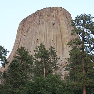
Devils Tower is a laccolithic butte composed of igneous rock in the Bear Lodge Mountains near Hulett and Sundance in Crook County, northeastern Wyoming, above the Belle Fourche River. It rises 1,267 feet above the Belle Fourche River, standing 867 feet from summit to base. The summit is 5,112 feet above sea level.

Black Elk Peak is the highest natural point in South Dakota, United States. It lies in the Black Elk Wilderness area, in southern Pennington County, in the Black Hills National Forest. The peak lies 3.7 mi (6.0 km) west-southwest of Mount Rushmore. At 7,242 feet (2,207 m), it has been described by the Board on Geographical Names as the highest summit in the United States east of the Rocky Mountains.

Covenant College is a Christian liberal arts college in Lookout Mountain, Georgia.

The Angeles National Forest (ANF) of the U.S. Forest Service is located in the San Gabriel Mountains and Sierra Pelona Mountains, primarily within Los Angeles County in southern California. The ANF manages a majority of the San Gabriel Mountains National Monument.

Black Mountain is the highest mountain peak in the Commonwealth of Kentucky, United States, with a summit elevation of 4,145 feet (1,263 m) above mean sea level and a top-to-bottom height of over 2,500 feet (760 m). The summit is located at approximately 36°54′51″N82°53′38″W in Harlan County, Kentucky near the Virginia border, just above the towns of Lynch, Kentucky and Appalachia, Virginia. It is about 500 feet (150 m) taller than any other mountain in Kentucky.

Bear Butte is a geological laccolith feature located near Sturgis, South Dakota, United States, that was established as a State Park in 1961. An important landmark and religious site for the Plains Indians tribes long before Europeans reached South Dakota, Bear Butte is called Mathó Pahá, or Bear Mountain, by the Lakota, or Sioux. To the Cheyenne, it is known as Noahȧ-vose or Náhkȯhe-vose, and is the place where Ma'heo'o (God) imparted to Sweet Medicine, a Cheyenne prophet, the knowledge from which the Cheyenne derive their religious, political, social, and economic customs.

Palomar Mountain is a mountain ridge in the Peninsular Ranges in northern San Diego County. It is famous as the location of the Palomar Observatory and Hale Telescope, and known for the Palomar Mountain State Park.

Cleveland National Forest encompasses 460,000 acres, mostly of chaparral, with a few riparian areas. A warm dry mediterranean climate prevails over the Forest. It is the southernmost National forest of California. It is administered by the United States Forest Service, a government agency within the United States Department of Agriculture. It is divided into the Descanso, Palomar and Trabuco Ranger Districts and is located in the counties of San Diego, Riverside, and Orange.

The Cape Lookout Lighthouse is a 163-foot high lighthouse located on the Southern Outer Banks of North Carolina. It flashes every 15 seconds and is visible at least 12 miles out to sea and up to 19 miles. The Cape Lookout Light is one of the very few lighthouses that operate during the day. It became fully automated in 1950. The Cape Lookout Lighthouse is the only such structure in the United States to bear the checkered daymark, intended not only for differentiation between similar light towers, but also to show direction. The center of the black diamonds points in a north-south direction, while the center of the white diamonds points east-west.

Saddleback Mountain is a mountain near Kiama in the Illawarra region of New South Wales, Australia. The mountain rises to about 600 metres (2,000 ft) above sea level on the Illawarra escarpment and has views of Noorinan Mountain, 662 metres (2,172 ft) above sea level, and Barren Grounds Plateau to the west and south to Coolangatta Mountain and Pigeon House Mountain to Ulladulla, and north over Lake Illawarra, the Illawarra escarpment and to the Cronulla Sandhills and Kurnell Oil Refinery on a clear day.

Shuckstack is a mountain in the Great Smoky Mountains of Swain County, North Carolina, in the southeastern United States. It has an elevation of 4,024 feet (1,227 m) above sea level, and rises approximately 2,300 feet (700 m) above Fontana Lake, to the south.

Mount Ord is a mountain summit located in the Tonto National Forest on the northeastern edge of Maricopa County, Arizona in the Mazatzal mountain range. The county line dividing Maricopa County, Arizona and Gila County, Arizona passes across the summit of the peak. It is not to be confused with the peak of Mount Baldy, Arizona, also referred to by some sources as "Mount Ord". It is named after Major General Edward Ord.

Albert Mountain is a mountain in North Carolina's Nantahala Range of the Appalachian Mountains. The Appalachian Trail goes along its summit, which is around 5,200 feet (1,600 m) high. A fire tower offers views of the Blue Ridge and the Little Tennessee River valley.

The Elk Mountains are a small range of mountains in western South Dakota, forming the southwest portion of the Black Hills as part of its west-dipping monocline. They are geologically distinct from the Black Hills, on the other side of a "racetrack" region of red stone. The ridge of the Elk Mountains is formed of harder sandstones. The east face of the Elk Mountains is a 300-to-800-foot high escarpment, but the west portion falls slowly and features many canyons. The mountains are about 3,800 feet (1,200 m) higher than the low prairie hills to their west.

The Bear Lodge Mountains are a small mountain range in Crook County, Wyoming. These mountains are protected in the Black Hills National Forest as part of its Bearlodge District. Devils Tower National Monument was the first U.S. National Monument and draws about 400,000 visitors per year to the area. The Bear Lodge Mountains are one of three mountain ranges that comprise the Black Hills region and national forest, including the Black Hills itself and South Dakota's Elk Mountains.

Carlile Junction is the populated place in Wyoming where Wyoming Highway 24 has a terminus at US Route 14.
Cicero Peak is a 6,168-foot (1,880 m) mountain in the Black Hills of Custer County, South Dakota. The mountain is 6 miles (9.7 km) south-southeast of the city of Custer, southwest of Custer State Park, and northwest of Wind Cave National Park. The closest community is Sanator, which is about 2 miles (3.2 km) northwest of Cicero Peak.

Allis State Park is a state park in Brookfield, Vermont. Established in 1928, Allis State Park is the second state park to be created in Vermont. It is named for Wallace Allis, who willed his Bear Mountain Farm to the State of Vermont to be developed as a campground and recreational area. The park was developed by the Civilian Conservation Corps (CCC) beginning in 1932, which built the access roads, constructed a picnic shelter, picnic grounds and a campground. There is a lookout tower on Bear Hill. Limited trash service, hot showers and running water are available. There are picnic tables, grills and fireplaces.