Belmont, Wisconsin

Last updated

Belmont, Wisconsin
First Capitol of Wisconsin in Belmont, Wisconsin LCCN2011630212.tif
Lafayette County Wisconsin Incorporated and Unincorporated areas Belmont Highlighted.svg
Location of Belmont in Lafayette County, Wisconsin.
Coordinates: 42°45′29″N90°21′54″W / 42.75806°N 90.36500°W / 42.75806; -90.36500
Country Flag of the United States.svg  United States
State Flag of Wisconsin.svg  Wisconsin
County Lafayette
Area
[1]
  Total0.88 sq mi (2.28 km2)
  Land0.88 sq mi (2.28 km2)
  Water0.00 sq mi (0.00 km2)
Elevation
[2]
1,181 ft (360 m)
Population
 (2020) [3]
  Total989
  Density1,106.58/sq mi (427.37/km2)
Time zone UTC-6 (Central (CST))
  Summer (DST) UTC-5 (CDT)
Area code 608
FIPS code 55-06450 [4]
GNIS feature ID1582788 [2]
Website www.belmontwi.com

Belmont is a village in Lafayette County, Wisconsin, United States. The population was 989 at the 2020 census. [5] It was the original capital of the Wisconsin Territory during the first legislative assembly in 1836.

Contents

History

Founded in 1835 by land speculator John Atchison, Belmont was the original capital of the Wisconsin Territory, and the original territorial capitol building is preserved several miles northwest of the village at First Capitol Historic Site. The village is adjacent to the Town of Belmont. The name Belmont comes from the French for “beautiful mountain”, referencing three hills within the village. [6]

Geography

According to the United States Census Bureau, the village has a total area of 0.88 square miles (2.28 km2), all of it land. [7] Belmont Mound State Park is located northwest of the village.

Demographics

Historical population
CensusPop.Note
1880 410
1890 378−7.8%
1900 50934.7%
1910 5324.5%
1920 498−6.4%
1930 452−9.2%
1940 4765.3%
1950 474−0.4%
1960 61630.0%
1970 68811.7%
1980 82620.1%
1990 823−0.4%
2000 8715.8%
2010 98613.2%
2020 9890.3%
U.S. Decennial Census [8] [5]

2010 census

As of the census [3] of 2010, there were 986 people, 439 households, and 279 families living in the village. The population density was 1,120.5 inhabitants per square mile (432.6/km2). There were 454 housing units at an average density of 515.9 per square mile (199.2/km2). The racial makeup of the village was 98.8% White, 0.2% African American, 0.2% Asian, 0.1% from other races, and 0.7% from two or more races. Hispanic or Latino people of any race were 0.7% of the population.

There were 439 households, of which 26.4% had children under the age of 18 living with them, 48.5% were married couples living together, 9.6% had a female householder with no husband present, 5.5% had a male householder with no wife present, and 36.4% were non-families. 31.2% of all households were made up of individuals, and 13.9% had someone living alone who was 65 years of age or older. The average household size was 2.25 and the average family size was 2.80.

The median age in the village was 39.8 years. 23.3% of residents were under the age of 18; 7.1% were between the ages of 18 and 24; 25.1% were from 25 to 44; 26.7% were from 45 to 64; and 18% were 65 years of age or older. The gender makeup of the village was 47.2% male and 52.8% female.

2000 census

As of the census [4] of 2000, there were 871 people, 377 households, and 245 families living in the village. The population density was 1,511.6 people per square mile (579.8/km2). There were 401 housing units at an average density of 695.9 per square mile (266.9/km2). The racial composition of the village was 99.66% White, 0.11% Black or African American, 0.11% Native American, and 0.11% from two or more races. 0.11% of the population were Hispanic or Latino of any race.

There were 377 households, of which 24.1% had children under the age of 18 living with them, 52.0% were married couples living together, 9.3% had a female householder with no husband present, and 35.0% were non-families. 30.0% of all households were composed of individuals, and 17.2% had someone living alone who was 65 years of age or older. The average household size was 2.31 and the average family size was 2.90.

In the village, the population was spread out, with 23.8% under the age of 18, 8.3% from 18 to 24, 24.8% from 25 to 44, 22.0% from 45 to 64, and 21.1% who were 65 years of age or older. The median age was 41 years. For every 100 females, there were 91.9 males. For every 100 females age 18 and over, there were 86.5 males.

The median income for a household in the village was $34,853, and the median income for a family was $49,688. Males had a median income of $28,646 versus $22,159 for females. The per capita income for the village was $17,763. About 1.7% of families and 5.4% of the population were below the poverty line, including 4.5% of those younger than age 18 and 9.6% of those age 65 or over.

Education

Belmont High School is the local high school.

Transportation

US-151 runs through town. Belmont, Wisconsin.jpg
US-151 runs through town.

For many years, U.S. Highway 151 was routed through Belmont. The highway was expanded to four lanes in 2004, with the new highway being routed to the north of the village.

Notable people

Related Research Articles

<span class="mw-page-title-main">Belmont, Ohio</span> Village in Ohio, United States

Belmont is a village in central Belmont County, Ohio, United States. The population was 414 at the 2020 census. It is part of the Wheeling metropolitan area.

<span class="mw-page-title-main">Flushing, Ohio</span> Village in Ohio, United States

Flushing is a village in Belmont County, Ohio, United States. The population was 830 at the 2020 census.

<span class="mw-page-title-main">Morristown, Ohio</span> Village in Ohio, United States

Morristown is a village in Belmont County, Ohio, United States. The population was 248 at the 2020 census. It is part of the Wheeling metropolitan area.

<span class="mw-page-title-main">Powhatan Point, Ohio</span> Village in Ohio, United States

Powhatan Point is a village in southeastern Belmont County, Ohio, United States, along the Ohio River. The population was 1,461 at the 2020 census. It is part of the Wheeling metropolitan area.

<span class="mw-page-title-main">Doylestown, Wisconsin</span> Village in Wisconsin, United States

Doylestown is a village in Columbia County, Wisconsin, United States. The population was 297 at the 2010 census. It is part of the Madison Metropolitan Statistical Area.

<span class="mw-page-title-main">Kekoskee, Wisconsin</span> Village in Wisconsin, United States

Kekoskee is a village in Dodge County, Wisconsin, United States. The population was 161 at the 2010 census.

<span class="mw-page-title-main">Taylor, Wisconsin</span> Village in Wisconsin, United States

Taylor is a village in Jackson County, Wisconsin, United States, along the Trempealeau River. The population was 484 at the 2020 census.

<span class="mw-page-title-main">Belmont, Portage County, Wisconsin</span> Town in Wisconsin, United States

Belmont is a town in Portage County, Wisconsin, United States. The population was 623 at the 2000 census. The unincorporated communities of Blaine and Dopp are located within the town. The unincorporated community of Heffron is located partially in the town.

<span class="mw-page-title-main">Boaz, Wisconsin</span> Village in Wisconsin, United States

Boaz is a village in Richland County, Wisconsin, United States. According to the 2010 census, the population of the village was 156.

<span class="mw-page-title-main">Big Falls, Waupaca County, Wisconsin</span> Village in Wisconsin, United States

Big Falls is a village in Waupaca County, Wisconsin, United States. The population was 61 at the 2010 census.

<span class="mw-page-title-main">Wilson, Ohio</span> Village in Ohio, United States

Wilson is a village in Belmont and Monroe counties in the U.S. state of Ohio. The population was 129 at the 2020 census. It is part of the Wheeling metropolitan area.

<span class="mw-page-title-main">Dorchester, Wisconsin</span> Village in Wisconsin, United States

Dorchester is a village in Clark and Marathon counties in the U.S. state of Wisconsin, along the 45th parallel. It is part of the Wausau, Wisconsin Metropolitan Statistical Area. The population was 876 at the 2010 census. Of this, 871 were in Clark County, and only 5 were in Marathon County.

<span class="mw-page-title-main">Viola, Wisconsin</span> Village in Wisconsin, United States

Viola is a village in Richland (mostly) and Vernon counties in the U.S. state of Wisconsin. The population was 699 at the 2010 census. Of this, 477 were in Richland County, and 222 were in Vernon County.

<span class="mw-page-title-main">Wyocena, Wisconsin</span> Village in Wisconsin, United States

Wyocena is a village in Columbia County, Wisconsin, United States. The population was 768 at the 2010 census. The village is located within the Town of Wyocena. It is part of the Madison Metropolitan Statistical Area.

<span class="mw-page-title-main">Lowell, Wisconsin</span> Village in Wisconsin, United States

Lowell is a village in Dodge County, Wisconsin, United States, along the Beaver Dam River. The population was 340 at the 2010 census. The village is located within the Town of Lowell.

<span class="mw-page-title-main">Mount Hope, Wisconsin</span> Village in Wisconsin, United States

Mount Hope is a village in Grant County, Wisconsin, United States. The population was 225 at the 2010 census. The village is located within the Town of Mount Hope.

<span class="mw-page-title-main">Melrose, Wisconsin</span> Village in Wisconsin, United States

Melrose is a village in Jackson County, Wisconsin, United States. The population was 503 at the 2010 census. The village is located within the Town of Melrose.

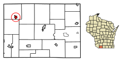
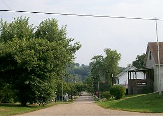
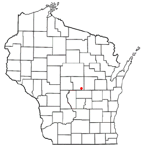
Belmont is a town in Lafayette County, Wisconsin, United States. The population was 767 at the 2010 census, up from 676 at the 2000 census. The village of Belmont is located in the southeastern part of the town. The unincorporated community of Leslie close to the center of the town.

<span class="mw-page-title-main">Wilton, Wisconsin</span> Village in Wisconsin, United States

Wilton is a village in Monroe County, Wisconsin, United States. The population was 504 at the 2010 census. The village is located partially within the Town of Wilton and partially within the Town of Wellington.

<span class="mw-page-title-main">Scandinavia, Wisconsin</span> Village in Wisconsin, United States

Scandinavia is a village in the Town of Scandinavia in Waupaca County, Wisconsin, United States. The population was 328 at the 2010 census.

References

  1. "2019 U.S. Gazetteer Files". United States Census Bureau. Retrieved August 7, 2020.
  2. 1 2 "US Board on Geographic Names". United States Geological Survey. October 25, 2007. Archived from the original on February 12, 2012. Retrieved January 31, 2008.
  3. 1 2 "U.S. Census website". United States Census Bureau . Retrieved November 18, 2012.
  4. 1 2 "U.S. Census website". United States Census Bureau . Retrieved January 31, 2008.
  5. 1 2 "Belmont village, Wisconsin". U.S. Census Bureau. Retrieved May 24, 2024.
  6. Gard, Robert (2015). The Romance of Wisconsin Place Names (2nd ed.). Madison, WI: Wisconsin Historical Society Press. p. 26. ISBN   978-0-87020-707-5.
  7. "US Gazetteer files 2010". United States Census Bureau. Archived from the original on July 2, 2012. Retrieved November 18, 2012.
  8. "Census of Population and Housing". Census.gov. Retrieved June 4, 2015.

Further reading