
A weather satellite or meteorological satellite is a type of Earth observation satellite that is primarily used to monitor the weather and climate of the Earth. Satellites can be polar orbiting, or geostationary.

L.F. Wade International Airport, formerly named Bermuda International Airport, is the sole airport serving the British overseas territory of Bermuda in the north Atlantic Ocean. It is located in the parish of St. George's and is 6 nautical miles northeast of Bermuda's capital, Hamilton. In 2016, the airport handled 402,925 passengers, up 5.6% from 2006. It has one passenger terminal, one cargo terminal, eight aircraft stands and can support all aircraft sizes up to and including the Airbus A380. Currently, nine passenger or cargo airlines operate seasonal or year-round scheduled services from the Azores, Canada, the United Kingdom, and the United States.
Hurricane Fabian was a powerful Cape Verde hurricane that impacted Bermuda in early September during the 2003 Atlantic hurricane season. It was the sixth named storm, fourth hurricane, and first major hurricane of the season, developed from a tropical wave in the tropical Atlantic Ocean on August 25. It moved west-northwestward under the influence of the subtropical ridge to its north, and steadily strengthened in an area of warm sea surface temperatures and light wind shear. The hurricane attained a peak intensity of 145 mph (233 km/h) on September 1, and it slowly weakened as it turned northward. On September 5, Fabian made a direct hit on Bermuda with wind speeds of over 120 mph (190 km/h). After passing the island, the hurricane turned to the northeast, and became extratropical on September 8, before dissipating two days later.

A weather ship, or ocean station vessel, was a ship stationed in the ocean for surface and upper air meteorological observations for use in weather forecasting. They were primarily located in the north Atlantic and north Pacific oceans, reporting via radio. The vessels aided in search and rescue operations, supported transatlantic flights, acted as research platforms for oceanographers, monitored marine pollution, and aided weather forecasting by weather forecasters and in computerized atmospheric models. Research vessels remain heavily used in oceanography, including physical oceanography and the integration of meteorological and climatological data in Earth system science.
The Caribbean Institute for Meteorology and Hydrology was established in 1967 by the member states, all current and ex-British colonies, of the Caribbean Meteorological Organisation (CMO). It was amalgamated with the Caribbean Operational Hydrological Institute (COHI) in the mid-1980s to form the Caribbean Institute for Meteorology and Hydrology (CIMH), but the name was only officially changed in September 1999 to reflect the dual role of the institute. Responsibility for the operation of the institute, which is located in Barbados, rests with the sixteen Commonwealth governments which comprise the CMO.

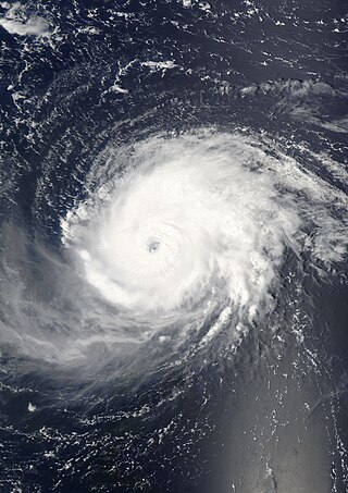
Hurricane Carrie was the strongest tropical cyclone of the 1957 Atlantic hurricane season. The third named storm and second hurricane of the year, Carrie formed from an easterly tropical wave off the western coast of Africa on September 2, a type of tropical cyclogenesis typical of Cape Verde-type hurricanes. Moving to the west, the storm gradually intensified, reaching hurricane strength on September 5. Carrie intensified further, before reaching peak intensity on September 8 as a Category 4 hurricane with maximum sustained winds of 140 mph (220 km/h) in the open Atlantic Ocean. The hurricane curved northwards and fluctuated in intensity as it neared Bermuda on September 14. However, Carrie passed well north of the island and turned to the northeast towards Europe. Weakening as it reached higher latitudes, the storm transitioned into an extratropical cyclone on September 23, prior to affecting areas of the British Isles, and subsequently dissipated on September 28.
HSBC Bank Bermuda Limited, previously the Bank of Bermuda Limited, is a financial services company in Bermuda providing retail and corporate banking, investment, custody and fund administration services to international and local clients. In 2004 the HSBC Group acquired the Bank of Bermuda, which has since become a focus for certain fund management and private banking activities. The bank sold much of its Cayman operations in 2014, and disposed its private banking operations at the end of April 2016. The three remaining divisions are retail banking wealth management, commercial banking and global banking and markets. These three businesses represent over 90% of total revenues.
The Fiji Meteorological Service (FMS) is a Department of the government of Fiji responsible for providing weather forecasts and is based on the grounds of Nadi Airport in Nadi. The current director of Fiji Meteorological Service is Misaeli Funaki. Since 1985, FMS has been responsible for naming and tracking tropical cyclones in the Southwest Pacific region. Current Meteorologists working at FMS have a Graduate Diploma in Meteorology from the Australian Bureau of Meteorology.

The Air Force Historical Research Agency (AFHRA) is the repository for United States Air Force historical documents. The Agency's collection began during World War II in Washington, D.C., and moved in 1949 to Maxwell Air Force Base, the site of Air University, to provide research facilities for professional military education students, the faculty, visiting scholars, and the general public.
The British Overseas Territory of Bermuda has been affected by several tornadoes and waterspouts in its history.

Naval Air Station Bermuda, was located on St. David's Island in the British Colony of Bermuda from 1970 to 1995, on the former site of Kindley Air Force Base. It is currently the site of Bermuda International Airport.
Butterfield, officially The Bank of N. T. Butterfield & Son Limited, is a bank founded and based in Bermuda. It provides services to clients from Bermuda, the Cayman Islands, Guernsey and Jersey, where its principal banking operations are located, and The Bahamas, Switzerland, Singapore and the United Kingdom, where it offers specialized financial services. Banking services comprise deposit, cash management and lending for individual, business and institutional clients. Wealth management services are composed of trust, private banking, asset management and custody. In Bermuda, the Cayman Islands and Guernsey, Butterfield offers both banking and wealth management. In The Bahamas, Singapore and Switzerland, Butterfield offers select wealth management services. In the UK, Butterfield offers residential property lending. In Jersey, it offers banking and wealth management services. Butterfield is publicly traded on the New York Stock Exchange and the Bermuda Stock Exchange.

USS Coos Bay (AVP-25) was a United States Navy Barnegat-class small seaplane tender in commission from 1943 to 1946 that saw service during the latter half of World War II. After the war, she was in commission in the United States Coast Guard from 1949 to 1966 as the cutter USCGC Coos Bay (WAVP-376), later WHEC-376.

Hurricane Igor was a very large Cape Verde hurricane and the most destructive tropical cyclone on record to strike the Canadian island of Newfoundland. It originated from a broad area of low pressure that moved off the western coast of Africa on September 6, 2010. Tracking slowly westward, it developed into a tropical depression on September 8 and strengthened into a tropical storm shortly thereafter. Higher wind shear temporarily halted intensification over the following days. On September 12, however, explosive intensification took place, and Igor reached Category 4 status on the Saffir–Simpson hurricane wind scale. By this time, Igor had already begun a prolonged turn around the western periphery of the subtropical ridge. After becoming the strongest cyclone of the season, with maximum sustained winds of 155 mph (249 km/h), it began to enter an area for continued strengthening. Igor gradually weakened before brushing Bermuda as a minimal hurricane on September 20. After turning northeastward, the system began an extratropical transition, which it completed shortly after striking southern Newfoundland. The remnants of Igor were later absorbed by another extratropical cyclone over the Labrador Sea on September 23.

The 1948 Bermuda–Newfoundland hurricane(Air Weather Service designation: Dog) was an intense and long-lived Cape Verde tropical cyclone that wrought significant damage to Bermuda and areas of Newfoundland in September 1948. The storm was the eighth named storm and third hurricane of the annual hurricane season. Originating as a tropical wave off the coast of Africa on September 4, the cyclone tracked a general westward path for much of its initial stages as it gradually intensified, reaching tropical storm intensity shortly after development and then hurricane intensity a day later. After reaching a longitude roughly equal to that of the Lesser Antilles, the hurricane began to curve northward on a parabolic track, bringing it near Bermuda at peak intensity as a Category 4 hurricane on September 13. Afterwards, the hurricane began to accelerate northeastwards and weaken. The waning tropical cyclone grazed Cape Race before transitioning into an extratropical cyclone on September 15; these remnants persisted for an additional day.

The Tuvalu Meteorological Service (TMS) is the principal meteorological observatory of Tuvalu and is responsible for providing weather services to the islands of Tuvalu. A meteorological office was established on Funafuti at the time the islands of Tuvalu were administered as parts of the Gilbert and Ellice Islands colony of the United Kingdom. The meteorological office is now an agency of the government of Tuvalu.

Hurricane Gonzalo was the second tropical cyclone, after Hurricane Fay, to directly strike the island of Bermuda in a one-week time frame in October 2014, and was the first Category 4 Atlantic hurricane since Hurricane Ophelia in 2011. At the time, it was the strongest hurricane in the Atlantic since Igor in 2010. Gonzalo struck Bermuda less than a week after the surprisingly fierce Hurricane Fay; 2014 was the first season in recorded history to feature two hurricane landfalls in Bermuda. A powerful Atlantic tropical cyclone that wrought destruction in the Leeward Islands and Bermuda, Gonzalo was the seventh named storm, sixth and final hurricane and only the second major hurricane of the below-average 2014 Atlantic hurricane season. The storm formed from a tropical wave on October 12, while located east of the Lesser Antilles. It made landfall on Antigua, Saint Martin, and Anguilla as a Category 1 hurricane, causing damage on those and nearby islands. Antigua and Barbuda sustained US$40 million in losses, and boats were abundantly damaged or destroyed throughout the northern Leeward Islands. The storm killed three people on Saint Martin and Saint Barthélemy. Gonzalo tracked northwestward as it intensified into a major hurricane. Eyewall replacement cycles led to fluctuations in the hurricane's structure and intensity, but on October 16, Gonzalo peaked with maximum sustained winds of 145 mph (235 km/h).

Severe Tropical Cyclone Gita was the most intense tropical cyclone to impact Tonga since reliable records began. The second named storm and first major tropical cyclone of the 2017–18 South Pacific cyclone season, Gita originated from a monsoon trough that was active in the South Pacific in early February 2018. First classified as a tropical disturbance on 3 February, the nascent system meandered near Vanuatu for several days with little development. After acquiring a steady east trajectory near Fiji, it organized into a Category 1 tropical cyclone on 9 February near Samoa. Arcing south in a clockwise turn, the system rapidly intensified, and became a severe tropical cyclone on 10 February near Niue.

Hurricane Paulette was a strong and long-lived Category 2 Atlantic hurricane which became the first to make landfall in Bermuda since Hurricane Gonzalo did so in 2014. The sixteenth named storm and sixth hurricane of the record-breaking 2020 Atlantic hurricane season, Paulette developed from a tropical wave that left the coast of Africa on September 2. The wave eventually consolidated into a tropical depression on September 7. Paulette fluctuated in intensity over the next few days, due to strong wind shear, initially peaking as a strong tropical storm on September 8. It eventually strengthened into a hurricane early on September 13 as shear decreased. On September 14, Paulette made landfall in northeastern Bermuda as a Category 2 hurricane, while making a gradual turn to the northeast. The cyclone further strengthened as it moved away from the island, reaching its peak intensity with 1-minute sustained winds of 105 mph (169 km/h) and a minimum central atmospheric pressure of 965 mbar (28.5 inHg) on September 14. On the evening of September 15, Paulette began to weaken and undergo extratropical transition, which it completed on September 16. The hurricane's extratropical remnants persisted and moved southward then eastward, and eventually, Paulette regenerated into a tropical storm early on September 20 south of the Azores– which resulted in the U.S National Weather Service coining the phrase "zombie storm" to describe its unusual regeneration. Paulette's second phase proved short-lived, however, as the storm quickly weakened and became post-tropical again two days later. The remnant persisted for several days before dissipating south of the Azores on September 28. In total, Paulette was a tropical cyclone for 11.25 days, and the system had an overall lifespan of 21 days.