Berrien Springs, Michigan

Last updated

Berrien Springs, Michigan
Berrien Springs Seal.png
Berrien Springs, MI location.png
Location within Berrien County
USA Michigan location map.svg
Red pog.svg
Berrien Springs
Location within the state of Michigan
Coordinates: 41°56′51″N86°20′25″W / 41.94750°N 86.34028°W / 41.94750; -86.34028
Country United States
State Michigan
County Berrien
Township Oronoko
Area
[1]
  Total1.00 sq mi (2.59 km2)
  Land0.92 sq mi (2.38 km2)
  Water0.08 sq mi (0.21 km2)
Elevation
673 ft (205 m)
Population
 (2020)
  Total1,910
  Density2,080.61/sq mi (803.43/km2)
Time zone UTC-5 (Eastern (EST))
  Summer (DST) UTC-4 (EDT)
ZIP code(s)
49103, 49104
Area code 269
FIPS code 26-07860 [2]
GNIS feature ID2398105 [3]
Website www.villageofberriensprings.com
Aerial view of Berrien Springs Berrien springs mi.jpg
Aerial view of Berrien Springs

Berrien Springs is a village in Berrien County in the U.S. state of Michigan. The population was 1,910 at the time of the 2020 census. [4] The village is located within Oronoko Charter Township.

Contents

History

Berrien Springs, like Berrien County, is named for John M. Berrien. "Springs" was added after mineral springs were discovered in the area. [5]

The village is the site of the earliest European-American settlement in Oronoko Township. It was first known as "Wolf's Prairie" in reference to the 1,000-acre prairie in which it was situated. The site had been a village under the leadership of a Potawatomi chief named Wolf. [6]

The first permanent settlers (according to European-American terms), John Pike and his family, did not arrive until 1829. [7]

Francis B. Murdoch was a co-founder of the village and the first lawyer in the county. (His surname was spelled as 'Murdock' in some records.) [8] [9] In 1831 he built a two-story log house, which is the oldest surviving example of its kind in Michigan. In 1973 this house was moved near courthouse square, to be part of that historic complex. [8]

Murdoch was known in the antebellum period for representing enslaved African Americans in freedom suits, in which they tried to gain freedom. Michigan was established as a free territory and later state. It went by the principle of "once free, always free". If slaveholders brought enslaved people to the state, the latter were judged to be free. [9]

The village of Berrien was platted in 1831. [7] The Berrien Springs post office opened with the name "Berrien" on December 4, 1832; this was changed to Berrien Springs on April 18, 1836. [10]

Berrien Springs served as the county seat from 1837 until 1894, when St. Joseph was designated as the county seat. [11]

1839 courthouse

Berrien Springs courthouse, designed by local architect Gilbert B. Avery, was completed in 1839, making it the oldest courthouse in the state. The Greek Revival-style courthouse emulated the architecture of ancient Greece with its large columns, triangular pediment and white paint. After the county seat was moved in 1894, the building was put to various uses and briefly was vacant. In 1967, efforts to preserve and restore the courthouse were started. Such restoration was completed by 1975. [12]

The restored courthouse square also features the Midwest's most complete surviving mid-nineteenth century county government complex. Today the square houses a county museum and archives. The courthouse serves as headquarters for the Berrien County Historical Association. Its original buildings are listed on the National Register of Historic Places. The property is dedicated to the preservation of Berrien County's history and does this through permanent and temporary exhibits, programs, events, and community outreach.

Christmas pickle capital of the world

Berrien Springs was once known as the Christmas pickle capital of the world. A festival was established by the Berrien Springs-Eau Claire Chamber of Commerce, the Berrien County Historical Association (BCHA), and the village. They featured parades, games, activities, and a Pickle Prince and Princess contest. The event ran until the mid-2000s. [13] [14] In 2021, the Pickle Festival was revived by the Village, the BCHA, and the Berrien Springs Community Library. [15]

Geography

According to the United States Census Bureau, the village has a total area of 1.02 square miles (2.64 km2), of which 0.94 square miles (2.43 km2) is land and 0.08 square miles (0.21 km2) is water. [16] The village is situated on the St. Joseph River.

Demographics

Historical population
CensusPop.Note
1870 662
1880 75814.5%
1890 745−1.7%
1900 8088.5%
1910 8808.9%
1920 9184.3%
1930 1,41353.9%
1940 1,5106.9%
1950 1,76116.6%
1960 1,95310.9%
1970 1,951−0.1%
1980 2,0424.7%
1990 1,927−5.6%
2000 1,862−3.4%
2010 1,800−3.3%
2020 1,9106.1%
U.S. Decennial Census [17]

2010 census

As of the census [18] of 2010, there were 1,800 people, 756 households, and 463 families living in the village. The population density was 1,914.9 inhabitants per square mile (739.3/km2). There were 837 housing units at an average density of 890.4 per square mile (343.8/km2). The racial makeup of the village was 72.7% White, 12.9% African American, 0.4% Native American, 5.1% Asian, 0.4% Pacific Islander, 3.8% from other races, and 4.7% from two or more races. Hispanic or Latino people of any race were 12.9% of the population.

There were 756 households, of which 30.2% had children under the age of 18 living with them, 40.9% were married couples living together, 16.0% had a female householder with no husband present, 4.4% had a male householder with no wife present, and 38.8% were non-families. 32.0% of all households were made up of individuals, and 11.2% had someone living alone who was 65 years of age or older. The average household size was 2.35 and the average family size was 2.95.

The median age in the village was 34.6 years. 22.8% of residents were under the age of 18; 13.1% were between the ages of 18 and 24; 27.2% were from 25 to 44; 23.3% were from 45 to 64; and 13.7% were 65 years of age or older. The gender makeup of the village was 47.9% male and 52.1% female.

2000 census

As of the census [2] of 2000, there were 1,862 people, 732 households, and 475 families living in the village. The population density was 2,059.6 inhabitants per square mile (795.2/km2). There were 787 housing units at an average density of 870.5 per square mile (336.1/km2). The racial makeup of the village was 77.12% White, 11.06% African American, 0.43% Native American, 4.03% Asian, 0.16% Pacific Islander, 4.30% from other races, and 2.90% from two or more races. Hispanic or Latino people of any race were 8.92% of the population.

There were 732 households, out of which 30.2% had children under the age of 18 living with them, 49.2% were married couples living together, 11.6% had a female householder with no husband present, and 35.0% were non-families. 29.8% of all households were made up of individuals, and 10.7% had someone living alone who was 65 years of age or older. The average household size was 2.46 and the average family size was 3.05.

In the village, 23.0% of the population was under the age of 18, 11.9% was from 18 to 24, 28.7% from 25 to 44, 21.0% from 45 to 64, and 15.3% was 65 years of age or older. The median age was 36 years. For every 100 females, there were 95.0 males. For every 100 females age 18 and over, there were 88.1 males.

The median income for a household in the village was $32,396, and the median income for a family was $41,250. Males had a median income of $31,467 versus $21,750 for females. The per capita income for the village was $16,093. About 12.4% of families and 17.5% of the population were below the poverty line, including 25.4% of those under age 18 and 4.1% of those age 65 or over.

Schools

Elementary

Secondary

Post-secondary

Notable people

Related Research Articles

<span class="mw-page-title-main">Berrien County, Michigan</span> County in Michigan, United States

Berrien County is a county in the U.S. state of Michigan. It is located at the southwest corner of the state's Lower Peninsula, located on the shore of Lake Michigan and sharing a land border with Indiana. As of the 2020 Census, the population was 154,316. The county seat is St. Joseph.

<span class="mw-page-title-main">Baroda, Michigan</span> Village in Michigan, United States

Baroda is a village in Berrien County in the U.S. state of Michigan. The population was 875 at the 2020 census. The village is within Baroda Township.

<span class="mw-page-title-main">Baroda Township, Michigan</span> Civil township in Michigan, United States

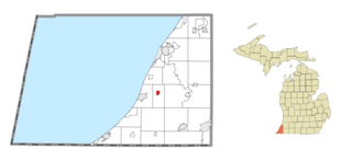
Baroda Township is a civil township of Berrien County in the U.S. state of Michigan. As of the 2020 census, the township population was 2,835.

<span class="mw-page-title-main">Berrien Township, Michigan</span> Civil township in Michigan, United States

Berrien Township is a civil township of Berrien County in the U.S. state of Michigan. As of the 2020 census, the township population was 4,868.

<span class="mw-page-title-main">Buchanan, Michigan</span> City in Michigan, United States

Buchanan is a city in Berrien County in the U.S. state of Michigan. The population was 4,300 at the 2020 census. The city is located at the southeast corner of Buchanan Township, about 5 miles (8.0 km) west of Niles.

<span class="mw-page-title-main">Buchanan Township, Michigan</span> Civil township in Michigan, United States

Buchanan Township is a civil township of Berrien County in the U.S. state of Michigan. As of the 2020 census, the township population was 3,436. The city of Buchanan is located in the southeast portion of the township.

<span class="mw-page-title-main">Chikaming Township, Michigan</span> Civil township in Michigan, United States

Chikaming Township is a civil township of Berrien County in the U.S. state of Michigan. As of the 2020 census, the township population was 2,778. The township is located in the west central portion of the county. Lake Michigan lies to the northwest, Lake Township is to the north and northeast, Weesaw Township is to the east, Three Oaks Township is to the south, and New Buffalo Township is to the southwest.

<span class="mw-page-title-main">Eau Claire, Michigan</span> Village in Michigan, United States

Eau Claire is a village located in east central Berrien County in the U.S. state of Michigan. The population was 552 at the 2020 census.

<span class="mw-page-title-main">Hagar Township, Michigan</span> Civil township in Michigan, United States

Hagar Township is a civil township of Berrien County in the U.S. state of Michigan. As of the 2020 census, the township population was 3,243.

<span class="mw-page-title-main">Lake Charter Township, Michigan</span> Charter township in Michigan, United States

Lake Charter Township is a charter township of Berrien County in the U.S. state of Michigan. The population was 3,316 at the 2020 census. The township is located in the west central portion of the county. Lake Michigan and the city of Bridgman are to the west, Lincoln Township to the north, Baroda Township to the east, Weesaw Township to the south, and Chikaming Township to the southwest.

<span class="mw-page-title-main">Lincoln Charter Township, Michigan</span> Charter township in Michigan, United States

Lincoln Charter Township is a charter township of Berrien County in the U.S. state of Michigan. The population was 14,929 at the 2020 census.

<span class="mw-page-title-main">Niles Charter Township, Michigan</span> Charter township in Michigan, United States

Niles Charter Township is a charter township of Berrien County in the U.S. state of Michigan. The population was 14,417 at the 2020 census.

<span class="mw-page-title-main">Oronoko Charter Township, Michigan</span> Charter township in Michigan, United States

Oronoko Charter Township is a charter township of Berrien County in the U.S. state of Michigan. The population was 9,226 at the 2020 census.

<span class="mw-page-title-main">Pipestone Township, Michigan</span> Civil township in Michigan, United States

Pipestone Township is a civil township of Berrien County in the U.S. state of Michigan. The population was 2,177 at the 2020 census. The township was organized on February 16, 1842.

<span class="mw-page-title-main">Royalton Township, Michigan</span> Civil township in Michigan, United States

Royalton Township is a civil township of Berrien County in the U.S. state of Michigan, a few miles southeast of the city of St. Joseph. The population was 5,141 at the 2020 census.

<span class="mw-page-title-main">Sodus Township, Michigan</span> Civil township in Michigan, United States

Sodus Township is a civil township of Berrien County in the U.S. state of Michigan. The population was 1,995 at the 2020 census. There are no incorporated municipalities in the township. The unincorporated community of Sodus in the northwest of the township is its main settlement; the portion of the township just to the west is part of the Benton Harbor/St. Joseph urban area.

<span class="mw-page-title-main">St. Joseph, Michigan</span> City in Michigan, United States

St. Joseph, colloquially known as St. Joe, is a city and the county seat of Berrien County, Michigan. It was incorporated as a village in 1834 and as a city in 1891. As of the 2020 census, the city population was 7,856. It lies on the shore of Lake Michigan, at the mouth of the St. Joseph River, about 90 miles (140 km) east-northeast of Chicago. It is home of the American Society of Agricultural and Biological Engineers.

<span class="mw-page-title-main">St. Joseph Charter Township, Michigan</span> Charter township in Michigan, United States

St. Joseph Charter Township is a charter township of Berrien County in the U.S. state of Michigan. The population was 9,993 at the 2020 census. The township is on the shores of Lake Michigan in the west central portion of the county, south of and adjacent to the city of St. Joseph.

<span class="mw-page-title-main">Stevensville, Michigan</span> Village in Michigan, United States

Stevensville is a village in Berrien County in the U.S. state of Michigan. The village lies within Lincoln Township. The population was 1,147 at the 2020 census.

<span class="mw-page-title-main">Three Oaks Township, Michigan</span> Civil township in Michigan, United States

Three Oaks Township is a civil township of Berrien County in the U.S. state of Michigan on the border with the state of Indiana. The population was 2,324 at the 2020 census.

References

Notes

  1. "2020 U.S. Gazetteer Files". United States Census Bureau. Retrieved May 21, 2022.
  2. 1 2 "U.S. Census website". United States Census Bureau . Retrieved January 31, 2008.
  3. U.S. Geological Survey Geographic Names Information System: Berrien Springs, Michigan
  4. "Berrien Springs village, Michigan - Census Bureau Profile". United States Census Bureau. Retrieved March 7, 2024.
  5. "Origins – Old Place Names". Berrien County Genealogical Society. Archived from the original on March 13, 2018. Retrieved March 13, 2018.
  6. Romig 1986, p. 58.
  7. 1 2 Coolidge, Orville W. (1906). A Twentieth Century History of Berrien County, Michigan, pp. 198–99. The Lewis Publishing Company.
  8. 1 2 Hyde, Charles K. (1976). The Lower Peninsula of Michigan: An Inventory of Historic Engineering and Industrial Sites. Department of the Interior, National Park Service, Office of Archeology and Historic Preservation, Historic American Engineering Record. p. 277.
  9. 1 2 3 "Murdock Log Cabin". Berrien County Historical Association. Retrieved February 1, 2022.
  10. U.S. Geological Survey Geographic Names Information System: Berrien Springs Post Office
  11. Community Profile, Village of Berrien Springs Archived August 20, 2008, at the Wayback Machine Berrien County official site
  12. Fedynsky, John (2010). Michigan's County Courthouses, pp. 24–25. The University of Michigan Press.
  13. Correspondent, KATE COLE / H.-P. "Annual pickle festival in Berrien Springs a tribute to heritage". The Herald Palladium. Retrieved February 6, 2022.
  14. "The History of the Christmas Pickle, a Zany Holiday Tradition". Good Housekeeping. November 16, 2020. Retrieved February 6, 2022.
  15. "Pickle Festival Coming Back To Berrien Springs | News/Talk/Sports 94.9 WSJM". www.wsjm.com. Retrieved February 6, 2022.
  16. "US Gazetteer files 2010". United States Census Bureau. Archived from the original on July 2, 2012. Retrieved November 25, 2012.
  17. "Census of Population and Housing". Census.gov. Retrieved June 4, 2015.
  18. "U.S. Census website". United States Census Bureau . Retrieved November 25, 2012.
  19. Tokars, Leanne (January 18, 2007). "Muhammad Ali: Still missed in Michigan". South Bend Tribune . Retrieved July 30, 2008.
  20. Mumford, Lou (January 21, 2007). "Ali's move could sting". South Bend Tribune . Retrieved July 30, 2008.

Sources