Pleasley is a village and civil parish with parts in both Derbyshire and Nottinghamshire. It lies between Chesterfield and Mansfield, 5 miles (8 km) south east of Bolsover, Derbyshire, England and 2.5 miles (4 km) north west of Mansfield, Nottinghamshire. The River Meden, which forms the county boundary in this area, runs through the village.

Gedling is a local government district with borough status in Nottinghamshire, England. The council is based in Arnold. The borough also includes Carlton along with villages and rural areas to the north-east of Nottingham. The main built-up part of the borough around Arnold and Carlton forms part of the Nottingham Urban Area.

Calverton is a village and civil parish in Nottinghamshire, England and of some 4,247 acres in size. It is in the Gedling district, about 7 miles (11 km) north-east of Nottingham, 10 miles (16 km) south-east of Mansfield, and situated, like nearby Woodborough and Lambley, on one of the small tributaries of the Dover Beck. The 2021 census found 7,282 inhabitants in 3,120 households. About 2 miles (3.2 km) miles to the north of the village is the site of the supposed deserted settlement of Salterford.

Hucknall, formerly Hucknall Torkard, is a market town in the Ashfield district of Nottinghamshire, England. It lies 7 miles (11 km) north of Nottingham, 7 miles (11 km) southeast of Kirkby-in-Ashfield, 9 miles (14 km) from Mansfield and 10 miles (16 km)south of Sutton-in-Ashfield. It is the second-largest town in the Ashfield district after Sutton-in-Ashfield.

Blidworth is a village and civil parish approximately five miles east of Mansfield, Nottinghamshire, England. The population of the civil parish at the 2011 census was 4,457, this dropped to 4,295 in the 2021 census. Its history can be traced back to the 10th century, although many of the current houses were built in the first half of the 20th century to provide housing for workers at Blidworth Colliery (1926–1989). These are mainly in estates north of Dale Lane, known as New Blidworth. The area around Main Street, west of Beck Lane and including the church, is Old Blidworth, containing some of the oldest buildings. Blidworth Bottoms is a hamlet about 0.5 km south of Old Blidworth, while Haywood Oaks is the portion of the village south of Dale Lane and the south eastern rural area of the parish surrounding Haywood Oaks Lane.

Sherwood is a constituency represented in the House of Commons of the UK Parliament since 2010 by Mark Spencer, a Conservative. The constituency's name is common with Sherwood Forest which is in the area.
The Dukeries is an area of the county of Nottinghamshire so called because it contained four ducal seats. It is south of Worksop, which has been called its "gateway". The area was included within the ancient Sherwood Forest. The ducal seats were:

Colwick is a village and civil parish, in the Borough of Gedling of Nottinghamshire, England. It is situated to the east of Nottingham's city boundary, and forms the Colwick ward. At the time of the 2011 census, the village had a population of 2,829, falling to 2,778 at the 2021 census.
Bestwood St. Albans is a former civil parish in the Gedling borough of Nottinghamshire, England. According to the 2001 census it had a population of 4,950. At the time of the 2011 census the population had increased to 5,259. The parish included the Bestwood Village and Bestwood Lodge areas, as well as Warren Hill, Warren Wood, Deer Park and 'The Gardens' on the northern outskirts of the Greater Nottingham conurbation, but not the area of Nottingham itself known as Bestwood.

Gedling is a village and former civil parish which gives its name to the larger Borough of Gedling in Nottinghamshire, England. It lies 4 miles (6.4 km) north-east of Nottingham city centre. The parish was abolished in 1935 and absorbed into the urban district of Carlton, which in turn was abolished in 1974 on the creation of borough of Gedling. The population of the Gedling ward at the 2011 census was 6,817 and 111,787 for the district. Gedling was recorded in the Domesday Book and is still a distinct settlement, although residential, commercial and industrial growth in the wider borough of Gedling and the neighbouring city of Nottingham, boroughs of Broxtowe and Rushcliffe and district of Ashfield means it can be difficult to distinguish the village of Gedling from the nearby town of Carlton, with which it has become contiguous.

Newstead is a village and civil parish in Nottinghamshire, England in the borough of Gedling. It is situated between the city of Nottingham and the towns of Kirkby-in-Ashfield, Sutton-in-Ashfield and Hucknall.
The Erewash Valley Line is a railway line in England, running from Long Eaton, located between Nottingham and Derby, and Clay Cross, near Chesterfield. The southern part was opened by the Midland Railway in 1847 as far as Codnor Park, where it connected to established ironworks, and soon after, a line to Pinxton and Mansfield.

Hidden Valleys is a name, coined in 2004, used to describe an area of interesting historical and scenic value between the city of Nottingham and the town of Mansfield in the English ceremonial county of Nottinghamshire. Promotional literature and tourist information for the Hidden Valleys were created to encourage tourism in an area that had been blighted by industrial decline. Partners in the project were: Ashfield District Council; Gedling Borough Council; the East Midlands Development Agency; Nottinghamshire County Council; and the Coalfields Regeneration Trust. It was intended by the partners that the name would help the Ashfield area compete with the Peak District and Sherwood Forest.
The Nottinghamshire Football Association, often known simply as the Notts FA, is the governing body of football in the county of Nottinghamshire, England. The Nottinghamshire FA runs a number of cups at different levels for teams across most of Nottinghamshire, as well as educating their affiliated clubs and members with relevant courses and events. A small number of clubs in the north of the county are members of the Sheffield and Hallamshire County Football Association.

Warren Hill is an area within the market town of Arnold in the English ceremonial county of Nottinghamshire. Located in the civil parish of St. Albans, it is in the local government district of Gedling. The area is roughly 1.5 miles (2.4 km) from Arnold town centre and about 4 miles (6 km) from Nottingham. The surrounding areas include Top Valley to the south, Rise Park to the west, Arnold and the suburb of Redhill to the east and Bestwood Country Park and Bestwood Village to the north. Most of the area consists of newly built housing estates with mainly 3-4 bedroom semi-detached houses as well as some newly built terraced housing and bungalows.

Bestwood Country Park is a country park near Bestwood Village, Nottinghamshire, England. Bestwood was a hunting estate owned by the Crown from the medieval period until the 17th century, when King Charles II gave it to his mistress, Nell Gwyn, and their son. In the Victorian era, Bestwood was the location of a coal mine which closed in 1967. It was established as a country park in 1973.
The Leen Valley lines of the Great Northern Railway were railway branch lines built to access the collieries in the Nottinghamshire coalfield in England. The Midland Railway had long been dominant in the area, but there was resentment against its monopolistic policies from coalowners, who encouraged the Great Northern Railway to build a line. The Leen Valley Line was opened in 1881; it ran as far as Annesley colliery. A passenger service was run the following year, and very considerable volumes of coal were hauled.

St. Albans is a civil parish in the Gedling borough of Nottinghamshire, England.

Kings Clipstone is a settlement and civil parish, in the Newark and Sherwood district, in the county of Nottinghamshire, England. The parish lies in the west of the county, and north west within the district. It is 122 miles north of London, 15 miles north of the city of Nottingham, and 5 miles north east of the market town of Mansfield. In the 2021 census, the parish had a population of 312. The parish touches Clipstone village, Edwinstowe, Rufford and Warsop. The parish was formerly part of the wider Clipstone parish, on 1 April 2011 it became a separate parish. The area is within Sherwood Forest, well known for the Robin Hood legend.
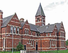
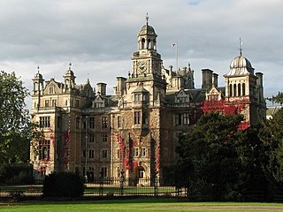
Bestwood St. Albans is a former civil parish in the Newark and Sherwood district of Nottinghamshire, England. The former parish contains 19 listed buildings that are recorded in the National Heritage List for England. Of these, four are at Grade II*, the middle of the three grades, and the others are at Grade II, the lowest grade. The former parish contains Bestwood Village and an area to the east. The listed buildings include a country house, later a hotel, and associated structures, smaller houses, a church and its lychgate, a water pumping station and associated structures, the winding house and headstocks of a former colliery, an office building, and a war memorial.