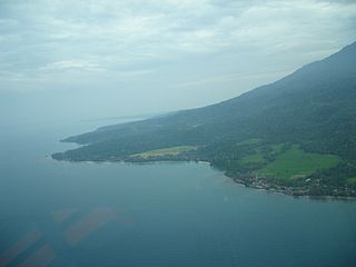
Timor is an island at the southern end of Maritime Southeast Asia, in the north of the Timor Sea. The island is divided between the sovereign states of East Timor on the eastern part and Indonesia on the western part. The Indonesian part, known as West Timor, constitutes part of the province of East Nusa Tenggara. Within West Timor lies an exclave of East Timor called Oecusse District. The island covers an area of 30,777 square kilometres. The name is a variant of timur, Malay for "east"; it is so called because it lies at the eastern end of the Lesser Sunda Islands. Mainland Australia is less than 500 km away, separated by the Timor Sea.
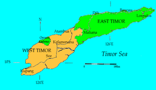
West Timor is an area covering the western part of the island of Timor, except for the district of Oecussi-Ambeno. Administratively, West Timor is part of East Nusa Tenggara Province, Indonesia. The capital as well as its main port is Kupang. During the colonial period, the area was named Dutch Timor and was a centre of Dutch loyalists during the Indonesian National Revolution (1945–1949). From 1949 to 1975 it was named Indonesian Timor.

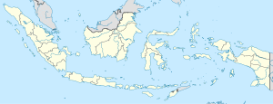
East Nusa Tenggara is the southernmost province of Indonesia. It comprises the eastern portion of the Lesser Sunda Islands, facing the Indian Ocean in the south and the Flores Sea in the north. It consists of more than 500 islands, with the largest ones being Sumba, Flores, and the western part of Timor; the latter shares a land border with the separate nation of East Timor. The province is subdivided into twenty-one regencies and the regency-level city of Kupang, which is the capital and largest city.
Halmahera, formerly known as Jilolo, Gilolo, or Jailolo, is the largest island in the Maluku Islands. It is part of the North Maluku province of Indonesia, and Sofifi, the capital of the province, is located on the west coast of the island.

Payakumbuh is the second largest city in West Sumatra province, Indonesia, with a population of 116,825 at the 2010 Census and 139,576 at the 2020 Census. It covers an area of 80.43 km² and is in the Minangkabau Highlands, 120 km by road from the West Sumatran capital city of Padang and 180 km from the Riau capital city of Pekanbaru.
Malaka or Malaca may refer to:

Tan Malaka was an Indonesian teacher, Marxist, philosopher, founder of Struggle Union and Murba Party, independent guerrilla, Indonesian fighter, and national hero. Tempo credited him as "Father of the Republic of Indonesia".
East Timor was a de facto province of Indonesia that existed between 1976 and 1999 during the Indonesian occupation of East Timor. Its territory corresponded to the previous Portuguese Timor and to the present-day independent country of Timor-Leste.
Atambua is the regency seat of Belu Regency, East Nusa Tenggara, Indonesia.

Belu Regency is a regency in East Nusa Tenggara province of Indonesia. Situated on the north of Timor island, it adjoins the separate nation of East Timor to the east. Established on 20 December 1958, Belu Regency has its seat (capital) in the large town of Atambua.
Sanggau Regency is a regency in the north-central section of West Kalimantan province of Indonesia. On 18 December 2003, the regency's eastern portion was split off to create a new regency called Sekadau, leaving Sanggau with an area of 12,857.8 km2 (5,000 sq mi). As of the 2020 census, Sanggau Regency had a population of 484,836; the official estimate as at mid 2021 was 488,527. Alongside Landak, Sekadau, and Sintang, it is one of four West Kalimantan regencies with a predominantly Catholic populations.

North Central Timor Regency is a regency in East Nusa Tenggara Province, Indonesia. It covers an area of 2,669.70 km2, and had a population of 229,803 at the 2010 Census and 259,829 at the 2020 Census; the official estimate as at mid 2022 was 268,067. Its regency seat is located at the town of Kefamenanu, which had a population of 49,095 in mid 2022. The regency borders Timor Leste's Oecusse enclave, one of few Indonesian regions that have a land border with other countries.
Lembata Regency is a regency in East Nusa Tenggara province of Indonesia. Established on 4 October 1999 from part of East Flores Regency, the regency covers the island of Lembata, together with three small offshore islands together forming the eastern part of the Solor Archipelago, and has its administrative seat (capital) in Lewoleba. The population of the Regency was 117,829 at the 2010 decennial census and at the 2020 census was 135,930; the official estimate as at mid 2022 was 139,787.
United Nations Security Council resolution 1319, adopted unanimously on 8 September 2000, after recalling previous resolutions on East Timor (Timor-Leste), the Council demanded that Indonesia take steps to disarm and disband militia on the island following the killing of three United Nations staff.
The Benanain River is a river of western Timor, Indonesia. This river is the longest and the largest di the West Timor area, with a length of 132 km. The river is located in three regencies: Malaka, Timor Tengah Utara and Timor Tengah Selatan, province East Nusa Tenggara, Indonesia. The upstream rises from Mount Mutis, flowing in the southeast direction until discharging to Timor Sea near Besikama.

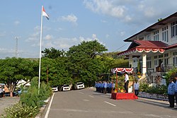
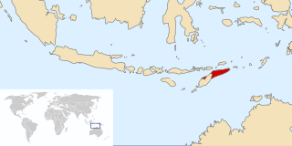
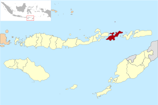
Malaka Regency is a regency in the province of East Nusa Tenggara, Indonesia. The regency was established on 14 December 2012, comprising twelve districts which had formerly been the southern part of Belu Regency.
The Poso Riots, also known as Poso Communal Conflict, is a name given to a series of riots that occurred in Poso, Central Sulawesi, Indonesia. This incident involved a group of Muslim and Christian in the region and is divided into three stages. The first Poso riot took place from December 25 to 29, 1998, continued from April 17 to 21, 2000, and finally from May 16 to June 15, 2000.
Salele is a village in East Timor located in the suco of Lalawa in the Tilomar Administrative Post of the Cova Lima Municipality. It is the location of the second main border crossing between the East Timor and Indonesia. The checkpoint on the Indonesian side of the border is called the Motamasin checkpoint.

Persatuan Sepakbola Malaka or simply PS Malaka is an Indonesian football club based in Malaka, East Nusa Tenggara. They currently play in Liga 3 and their homeground is Betun Field.

Persami is an Indonesian football club based in Gelora Samador Stadium, Maumere, Sikka Regency, East Nusa Tenggara. This team competes in Liga 3 East Nusa Tenggara Zone.