| Beverly Gardens Park | |
|---|---|
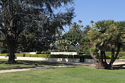 Beverly Gardens Park and the Beverly Hills sign | |
 | |
| Location | Beverly Hills, California |
| Created | 1911 |
| Open | All year |
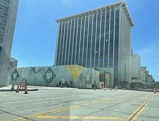
Beverly Gardens Park is a public park in Beverly Hills, California.
Contents

| Beverly Gardens Park | |
|---|---|
| Beverly Gardens Park and the Beverly Hills sign | |
| | |
| Location | Beverly Hills, California |
| Created | 1911 |
| Open | All year |
Beverly Gardens Park is a public park in Beverly Hills, California.
The land is built on a portion of Rancho Rodeo de las Aguas. It was opened in 1911.
Beverly Gardens Park is 22 block long and stretches along Santa Monica Boulevard in Beverly Hills, California for 1.9 miles (3.1 km). It was designed by landscape architect Ralph D. Cornell. [1] [2]
The park serves to provide a lengthy green swath between the northern residential area and the commercial sections of the city. It features a two-mile jogging path, many hundred-year-old cypress and ficus trees, gardens, sculpture, and the big, iconic Beverly Hills Sign, a re-creation of the original arching, lighted historic sign, built near the city's center.
The semiannual art fair, The Beverly Hills Art Show, is held on the park's central blocks, during the third weekend of every May and the third weekend of each October. Approximately 250 artists from around Los Angeles and throughout the United States are selected to display work, and up to 50,000 patrons attend throughout the weekend.
A permanent collection of Public Art includes the Electric Fountain at the far west end of the linear park, at the intersection of Santa Monica and Wilshire Boulevards. Near Rodeo Drive stands a sculpture of psychedelic tulips by Yayoi Kusama, called Hymn to Life, sculpted and produced in the art department at Ironwood by Mat McKim and Nick Petronzio. Other contemporary public art by sculptors such as Barry Flanagan, Tony Smith and Magdalena Abramovicz are installed on the garden grounds in the vicinity of Beverly Hills City Hall. Historic fountains, historic arbors, and specialty gardens devoted to roses, cacti, succulents, and palms are also visible to drivers and pedestrians along the north side of Santa Monica Boulevard, from Doheny Drive to Whittier Drive.

Beverly Hills is a city located in Los Angeles County, California, United States. A notable and historic suburb of Los Angeles, it is located just southwest of the Hollywood Hills, approximately 12.2 miles (19.6 km) northwest of downtown Los Angeles. Beverly Hills' land area totals to 5.71 square miles (14.8 km2), and is entirely surrounded by the city of Los Angeles. According to the 2020 census, the city has a population of 32,701; marking a decrease of 1,408 from the 2010 census count of 34,109.
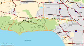
Mulholland Drive is a street and road in the eastern Santa Monica Mountains of Southern California. It is named after pioneering Los Angeles civil engineer William Mulholland. The western rural portion in Los Angeles and Ventura Counties is named Mulholland Highway. The road is featured in a significant number of films, songs, and novels. David Lynch, who wrote and directed a film named after Mulholland Drive, has said that one can feel "the history of Hollywood" on it. Jack Nicholson has lived on Mulholland Drive for many years, and still did so as of 2009.
The Los Angeles Westside is an urban region in western Los Angeles County, California, United States. It has no official definition, but sources like LA Weekly and the Mapping L.A. survey of the Los Angeles Times place the region on the western side of the Los Angeles Basin south of the Santa Monica Mountains.
State Route 2 (SR 2) is a state highway in the U.S. state of California. It connects the Los Angeles Basin with the San Gabriel Mountains and the Victor Valley in the Mojave Desert. The highway's southwestern end is at the intersection of Centinela Avenue at the Santa Monica-Los Angeles border and its northeastern end is at SR 138 east of Wrightwood. The SR 2 is divided into four segments, and it briefly runs concurrently with U.S. Route 101 (US 101) and Interstate 210 (I-210). The southwestern section of SR 2 runs along a segment of the east–west Santa Monica Boulevard, an old routing of US 66, to US 101 in East Hollywood; the second section runs along segments of both the north–south Alvarado Street and Glendale Boulevard in Echo Park; the third section to I-210 in Glendale is known as the north–south Glendale Freeway; and the northeastern portion from I-210 in La Cañada Flintridge to SR 138 is designated as the Angeles Crest Highway.

Rodeo Drive is a two-mile-long (3.2 km) street in Beverly Hills, California, with its southern segment in the City of Los Angeles, known as one of the most expensive streets in the world. Its southern terminus is at Beverwil Drive, and its northern terminus is at its intersection with Sunset Boulevard in Beverly Hills. The name is most commonly used metonymically to refer to the three-block stretch of the street between Wilshire Boulevard and Little Santa Monica Boulevard.

Little Armenia is a neighborhood in Central Los Angeles, California. It is named after the Armenians who escaped genocide and made their way to Los Angeles during the early part of the 20th century.
Mulholland Highway is a scenic road in Los Angeles County, California, that runs approximately 50 miles through the western Santa Monica Mountains from near US Route 101 in Calabasas to Highway 1 near Malibu at Leo Carrillo State Park and the Pacific Ocean coast – at the border of Los Angeles and Ventura Counties.

The Third Street Promenade is a pedestrian mall esplanade, shopping, dining and entertainment complex in the downtown area of Santa Monica, California which originally opened as the Santa Monica Mall on November 8, 1965. It is considered a premier shopping and dining district on the Westside and draws crowds from all over the Greater Los Angeles area. Due to easy access to Downtown Los Angeles via the Big Blue Bus rapid transit service, E Line's terminus station and the Pacific Coast Highway-Santa Monica Freeway Interstate, the neighborhood's north-south thoroughfares connecting to Muscle Beach, Venice Canal Historic District, Marina del Rey, Ballona Wetlands and Los Angeles International Airport, and its proximity to historic U.S. Route 66, Santa Monica Pier, Palisades Park, Tongva Park, Santa Monica State Beach and the Pacific Ocean coupled with Los Angeles's mild mediterranean climate, it is also a popular tourist destination.

Wilshire Boulevard (['wɪɫ.ʃɚ]) is a prominent 15.83 mi (25.48 km) boulevard in the Los Angeles area of Southern California, extending from Ocean Avenue in the city of Santa Monica east to Grand Avenue in the Financial District of downtown Los Angeles. One of the principal east–west arterial roads of Los Angeles, it is also one of the major city streets through the city of Beverly Hills. Wilshire Boulevard runs roughly parallel to Santa Monica Boulevard from Santa Monica to the west boundary of Beverly Hills. From the east boundary, it runs a block south of Sixth Street to its terminus.

Santa Monica Boulevard is a major west–east thoroughfare in Los Angeles County, California, United States. It runs from Ocean Avenue in Santa Monica near the Pacific Ocean to Sunset Boulevard at Sunset Junction in Los Angeles. It passes through Beverly Hills and West Hollywood. A portion of it is designated as California State Route 2, while the full avenue was Historic Route 66.

Olympic Boulevard is a major arterial road in Los Angeles, California. It stretches from Ocean Avenue on the western end of Santa Monica to East Los Angeles—farther than Wilshire Boulevard and most other streets.

Beverly Drive is a major north–south roadway in Beverly Hills and Los Angeles.

The Electric Fountain is a water fountain with public art sculptures and evening lighting, surrounded by mosaic pavement, seating, and landscaping. It is located in Beverly Gardens Park on the corner of Santa Monica and Wilshire Boulevards in Beverly Hills, California.

Rancho Rodeo de las Aguas was a 4,539-acre (18.37 km2) land grant in present day Beverly Hills, Los Angeles County, California given to María Rita Quinteros Valdez de Villa in 1838.

The Sawtelle Line was an interurban railway route primarily operated by the Pacific Electric Railway that ran between Downtown Los Angeles and Santa Monica, California. The line was established by the Pasadena and Pacific Railway between 1896 and 1901, with passenger service running until 1940.

The Peninsula Beverly Hills is a luxury, five-star hotel at the intersection of South Santa Monica Boulevard and Wilshire Boulevard. The hotel is part of The Peninsula Hotels, a chain owned by Hongkong and Shanghai Hotels. The Peninsula Beverly Hills was the second Peninsula branded hotel to open in the United States, with The Peninsula New York having opened three years earlier in 1988. When the hotel opened in 1991 it was the first new luxury hotel in Beverly Hills in 20 years.
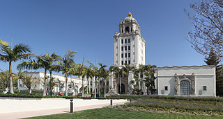
The Beverly Hills City Hall is a historic building and city hall in Beverly Hills, California, United States.

Mulholland Estates is a guard gated community in the Santa Monica Mountains of Southern California, US. It is named after pioneering Los Angeles civil engineer William Mulholland. Although properties in the estate have a 90210 ZIP code and thus a Beverly Hills address, it is actually part of the Beverly Hills Post Office area in the city of Los Angeles, with much of the land located inside the Sherman Oaks district. The community's main entrance is located at Beverly Glen Boulevard and Mulholland Drive, next to Fossil Ridge Park, and it looks out to the San Fernando Valley.
Wilshire/Rodeo station is an under construction, underground rapid transit station on the D Line of the Los Angeles Metro Rail system. It is currently under construction as part of the D Line Extension project, in Beverly Hills, California. Construction started in 2018 as part of Section 2 of the extension project. It is slated to open in 2026.
Education | |
| Primary and secondary schools | |
| Other education | |
Government | |
| City government | |
Other | |
| Hotels | |
| Other landmarks | |
| Notable restaurants | |
| Media | |
Defunct | |
34°4′20″N118°24′12″W / 34.07222°N 118.40333°W
| | This Los Angeles County, California–related article is a stub. You can help Wikipedia by expanding it. |