
Thuringia, officially the Free State of Thuringia, is a state of central Germany, covering 16,171 square kilometres (6,244 sq mi), the sixth smallest of the sixteen German states. It has a population of about 2.1 million.

Weimar is a city in the state of Thuringia, Germany. It is located in Central Germany between Erfurt in the west and Jena in the east, approximately 80 kilometres southwest of Leipzig, 170 kilometres north of Nuremberg and 170 kilometres west of Dresden. Together with the neighbouring cities of Erfurt and Jena, it forms the central metropolitan area of Thuringia, with approximately 500,000 inhabitants. The city itself has a population of 65,000. Weimar is well known because of its large cultural heritage and its importance in German history.

Gera is a city in the German state of Thuringia. With around 93,000 inhabitants, it is the third-largest city in Thuringia after Erfurt and Jena as well as the easternmost city of the Thüringer Städtekette, an almost straight string of cities consisting of the six largest Thuringian cities from Eisenach in the west, via Gotha, Erfurt, Weimar and Jena to Gera in the east. Gera is the largest city in the Vogtland, and one of its historical capitals along with Plauen, Greiz and Weida. The city lies in the East Thuringian Hill Country, in the wide valley of the White Elster, between Greiz (upstream) and Leipzig (downstream). Gera is located in the Central German Metropolitan Region, approximately 60 kilometres south of Saxony's largest city of Leipzig, 80 km east of Thuringia's capital Erfurt, 120 km west of Saxony's capital Dresden and 90 km north of Bavaria's city of Hof (Saale).
The Province of Saxony, also known as Prussian Saxony was a province of the Kingdom of Prussia and later the Free State of Prussia from 1816 until 1944. Its capital was Magdeburg.

Blankenhain is a town in the Weimarer Land district, in Thuringia, Germany. It is 14 km south of Weimar.
The administrative divisions of the German Democratic Republic were constituted in two different forms during the country's history. The GDR first retained the traditional German division into federated states called Länder, but in 1952 they were replaced with districts called Bezirke. Immediately before German reunification in 1990, the Länder were restored, but they were not effectively reconstituted until after reunification had completed.

The Bezirk Potsdam was a district (Bezirk) of East Germany. The administrative seat and the main town was Potsdam.

The Bezirk Dresden was a district (Bezirk) of East Germany that lasted from 1952 to 1990. Dresden would be reabsorbed back into Saxony after the reunification of Germany. The administrative seat and the main town was Dresden.
The Bezirk Leipzig was a district (Bezirk) of East Germany that would last from 1952 to 1990. Leipzig would be reabsorbed into Saxony after the reunification of Germany. The administrative seat and the main town was Leipzig.

The Bezirk Karl-Marx-Stadt, also known as Bezirk Chemnitz, was a district (Bezirk) of East Germany. The district would last from 1952 up to the Reunification of Germany in 1990. The administrative seat and the main town was Karl-Marx-Stadt, renamed back to Chemnitz during the reunification of Germany.

The Bezirk Frankfurt, also Bezirk Frankfurt (Oder), was a district (Bezirk) of East Germany. The administrative seat and the main town was Frankfurt (Oder).

The Bezirk Rostock was a district (Bezirk) of East Germany. The administrative seat and the main town was Rostock.
The Bezirk Magdeburg was a district (Bezirk) of East Germany. The administrative seat and the main town was Magdeburg.

The Bezirk Halle was a district (Bezirk) of East Germany. The administrative seat and the main town was Halle.

The Bezirk Schwerin was a district (Bezirk) of East Germany. The administrative seat and the main town was Schwerin.

Bezirk Cottbus was a district of the German Democratic Republic. The administrative seat and main town was Cottbus.

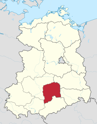
The Bezirk Gera was a district (Bezirk) of East Germany. The administrative seat and main town was Gera.

The Bezirk Neubrandenburg was a district (Bezirk) of East Germany. The administrative seat and the main town was Neubrandenburg.

The Bezirk Suhl was a district (Bezirk) of East Germany. The administrative seat and the main town was Suhl.
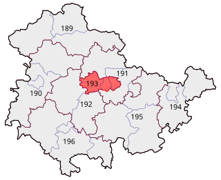
Erfurt – Weimar – Weimarer Land II is an electoral constituency represented in the Bundestag. It elects one member via first-past-the-post voting. Under the current constituency numbering system, it is designated as constituency 193. It is located in central Thuringia, comprising the cities of Erfurt and Weimar as well as the municipality of Grammetal from the Weimarer Land district.


