
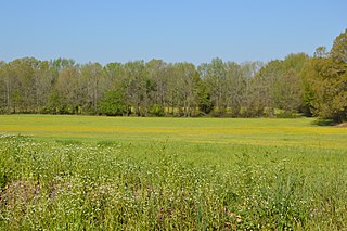
Fort Pillow State Historic Park is a state park in western Tennessee that preserves the American Civil War site of the Battle of Fort Pillow. The 1,642 acre (6.6 km²) Fort Pillow, located in Lauderdale County on the Chickasaw Bluffs overlooking the Mississippi River, is rich in both historic and archaeological significance. In 1861, the Confederate army built extensive fortifications and named the site for General Gideon Johnson Pillow of Maury County. It was attacked and held by the Union Army for most of the American Civil War period except immediately after the Battle of Fort Pillow, when it was retaken by the Confederate Army. The battle ended with a massacre of African-American Union troops and their white officers attempting to surrender, by soldiers under the command of Confederate Major General Nathan Bedford Forrest. Interpretive sites are part of the park.

Kaloko-Honokōhau National Historical Park is a United States National Historical Park located in the Kona District on the Big island of Hawaiʻi in the U.S. state of Hawaiʻi. It includes the National Historic Landmarked archaeological site known as the Honokōhau Settlement. The park was established on November 10, 1978, for the preservation, protection and interpretation of traditional native Hawaiian activities and culture.

The National Register of Historic Places in the United States is a register including buildings, sites, structures, districts, and objects. The Register automatically includes all National Historic Landmarks as well as all historic areas administered by the U.S. National Park Service. Since its introduction in 1966, more than 90,000 separate listings have been added to the register.
The Siege and Battle of Corinth Sites are a National Historic Landmark District encompassing surviving elements of three significant American Civil War engagements in and near Corinth, Mississippi. Included are landscape and battlefield features of the Siege of Corinth, the Second Battle of Corinth, and the lesser Battle of Hatchie's Bridge on October 5, 1862. The district includes features located in both Alcorn County, Mississippi and Hardeman County, Tennessee, with some of the former preserved as part of Shiloh National Military Park. It was designated a landmark in 1991.

Big Mound City (8PB48) is a prehistoric site near Canal Point, Florida, United States. It is located 10 miles east of Canal Point, off U.S. Route 98. On May 24, 1973, it was added to the U.S. National Register of Historic Places. It is located inside the J.W. Corbett Wildlife Management Area.
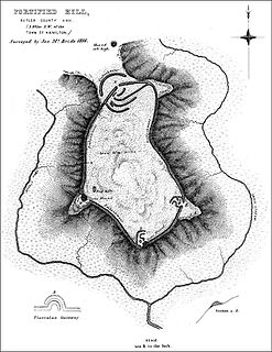
Fortified Hill Works is a registered historic site near Hamilton, Ohio, listed in the National Register on July 12, 1974.
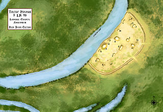
Toltec Mounds Archeological State Park, also known as Knapp Mounds, Toltec Mounds Site or Toltec Mounds, is an archaeological site from the Late Woodland period in Arkansas that protects an 18-mound complex with the tallest surviving prehistoric mounds in Arkansas. The site is on the banks of Mound Lake, an oxbow lake of the Arkansas River. It was occupied by its original inhabitants from 600 to 1050 CE. The site is designated as a National Historic Landmark.
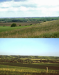
The Blood Run Site is an archaeological site on the border of the US states of Iowa and South Dakota. The site was essentially populated for 8,500 years, within which earthworks structures were built by the Oneota Culture and occupied descendant tribes such as the Ioway, Otoe, Missouri, and shared with Quapaw and later Kansa, Osage, and Omaha people. The site was so named on account of the iron-stained soil.

Edwin Warner Park and Percy Warner Park, collectively known as Warner Parks, are two major public parks in Nashville, Tennessee. They are part of the park system managed by the Metropolitan Board of Parks and Recreation of Nashville and Davidson County. Percy Warner Park's front entrance is located at the end of Belle Meade Boulevard. The parks are listed on the National Register of Historic Places as Warner Park Historic District. The district is primarily within Nashville along the southern edge of Davidson County, Tennessee, but it extends into Williamson County, Tennessee as well.

Roxbury High Fort is a historic fort site on Beech Glen Street at Fort Avenue in the Roxbury neighborhood of Boston, Massachusetts. The site now contains a small park and the Cochituate Standpipe, also known as Fort Hill Tower, built in 1869. The fort site was added to the National Register of Historic Places in 1973. The site inspired the name of the Fort Hill neighborhood, which surrounds the area of the High Fort.

The Hopeton Earthworks are an Ohio Hopewell culture archaeological site consisting of mounds and earthwork enclosures. It is located on the eastern bank of the Scioto River just north of Chillicothe in Ross County, Ohio, about a mile east of the Mound City Group and Shriver Circle on a terrace of the Scioto River. The site is a detached portion of the Hopewell Culture National Historic Park, along with the Mound City Group, Hopewell Mound Group, Seip Earthworks, Spruce Hill Earthworks and the High Bank Works. The site is open to the public.

The Middlesex Fells Reservoirs Historic District is a historic district roughly bounded by Pond St., Woodland Rd., I-93, and MA 28 in Stoneham and Medford, Massachusetts. It encompasses a portion of the Middlesex Fells Reservation, a state park managed by the Massachusetts Department of Conservation and Recreation (DCR). The principal features of the district are three reservoirs and their associated gate houses and pumping stations, which were developed by the Metropolitan District Commission starting in the late 19th century. The district was listed on the National Register of Historic Places in 1990.

Sellars Farm Site (40WI1), also known as the Sellars Farm State Archaeological Area and Sellars Indian Mound, is a Mississippian culture archaeological site located in Wilson County, Tennessee near Lebanon. The platform mound was the site of a settlement from about 1000 to 1300 CE. Today, the site is a satellite unit of Long Hunter State Park. The non-profit Friends of the Sellars Farm State Archaeological Area organization conducts tours and upkeep of the site. It was listed on the National Register of Historic Places on December 11, 1972.

The Refreshment Pavilion is a historic refreshment stand at Houghton's Pond in the Milton portion of Blue Hills Reservation, a Massachusetts state park. Built in 1920, it is one of a series of architect-designed structures built in the park by the Metropolitan District Commission. It was listed on the National Register of Historic Places in 1980.

The Dunns Pond Mound is a historic Native American mound in northeastern Logan County, Ohio, United States. Located near Huntsville, it lies along the southeastern corner of Indian Lake in Washington Township. In 1974, the mound was listed on the National Register of Historic Places as a potential archeological site, with much of its significance deriving from its use as a burial site for as much as nine centuries.

Old Town is an archaeological site in Williamson County, Tennessee near Franklin. The site includes the remnants of a Native American village and mound complex of the Mississippian culture, and is listed on the National Register of Historic Places (NRHP) as Old Town Archaeological Site (40WM2).

The Rocky Fork Park Site is an archaeological site in the southeastern part of the U.S. state of Ohio. Located in Rocky Fork State Park in eastern Highland County, the site's earthworks have been designated a historic site because of their archaeological importance.

Too-Cowee, was an important historic Cherokee town located near the Little Tennessee River north of present-day Franklin, North Carolina. It also had a prehistoric platform mound and earlier village built by ancestral peoples. As their expression of public architecture, the Cherokee built a townhouse on top of the mound. It was the place for their community gatherings in their highly decentralized society. The name translates to "pig fat" in English. British traders and colonists referred to Cowee as one of the Cherokee Middle Towns along this river; they defined geographic groupings based in relation to their coastal settlements, such as Charlestown, South Carolina.
Nununyi was a historic village of the Cherokee people in western North Carolina, located on the eastern side of the Oconaluftee River. Today it is within the boundaries of the present-day city of Cherokee in Swain County. It was classified by English traders and colonists as among the "Out Towns" of the Cherokee in this area east of the Appalachian Mountains.
The Orwell Site, designated 21OT7 in the state archaeological inventory, is a historic site located near Fergus Falls, Minnesota, United States. It consists of twelve Middle or Late Woodland period burial mounds, four of which are enclosed by an earthwork. They were built from about A.D. 350–600. They share similarities with the mounds found at Fort Juelson, also in Otter Tail County, with their central burial chamber. The site was listed on the National Register of Historic Places in 1974.
