Big Sandy, Tennessee

Last updated

Big Sandy
Lossy-page1-607px-Big Sandy Creek ,Tennessee, Business District - NARA - 279785 CROPPED.jpg
Downtown Big Sandy, 1936
Benton County Tennessee Incorporated and Unincorporated areas Big Sandy Highlighted 4705860.svg
Location of Big Sandy in Benton County, Tennessee.
Coordinates: 36°14′3″N88°5′9″W / 36.23417°N 88.08583°W / 36.23417; -88.08583
Country United States
State Tennessee
County Benton
Settled1861
Incorporated1903
Government
  MayorAutumn Ratliff
Area
[1]
  Total0.63 sq mi (1.63 km2)
  Land0.63 sq mi (1.63 km2)
  Water0.00 sq mi (0.00 km2)
Elevation
371 ft (113 m)
Population
 (2020) [2]
  Total486
  Density773.89/sq mi (298.90/km2)
Time zone UTC-6 (Central (CST))
  Summer (DST) UTC-5 (CDT)
ZIP code
38221
Area code 731
FIPS code 47-05860 [3]
GNIS feature ID1277379 [4]
Website www.bigsandytn.com

Big Sandy is a town in Benton County, Tennessee. The population was 486 at the 2020 census. [5]

Contents

History

In the late 1850s the Memphis & Ohio Railroad constructed a line south of what is now Kentucky Lake. A community formed around a water tank and fuel yard. By 1903, the town of Big Sandy was incorporated. [6]

Geography

Big Sandy is located at 36°14′3″N88°5′9″W / 36.23417°N 88.08583°W / 36.23417; -88.08583 (36.234203, -88.085869). [7]

According to the United States Census Bureau, the town has a total area of 0.7 square miles (1.8 km2), all land.

Big Sandy is concentrated around the intersection of State Route 69A and State Route 147.

Climate

Climate data for Big Sandy, Tennessee, 1991–2020 normals, extremes 1997present
MonthJanFebMarAprMayJunJulAugSepOctNovDecYear
Record high °F (°C)75
(24)
80
(27)
87
(31)
91
(33)
94
(34)
104
(40)
105
(41)
105
(41)
101
(38)
95
(35)
86
(30)
78
(26)
105
(41)
Mean maximum °F (°C)68.5
(20.3)
72.7
(22.6)
81.3
(27.4)
86.8
(30.4)
89.6
(32.0)
94.5
(34.7)
95.6
(35.3)
96.8
(36.0)
93.5
(34.2)
87.1
(30.6)
77.1
(25.1)
70.9
(21.6)
97.7
(36.5)
Mean daily maximum °F (°C)47.0
(8.3)
52.0
(11.1)
61.8
(16.6)
71.5
(21.9)
78.6
(25.9)
85.5
(29.7)
88.4
(31.3)
88.0
(31.1)
82.3
(27.9)
71.7
(22.1)
60.3
(15.7)
49.9
(9.9)
69.7
(21.0)
Daily mean °F (°C)38.1
(3.4)
42.3
(5.7)
50.4
(10.2)
59.3
(15.2)
68.0
(20.0)
75.7
(24.3)
78.9
(26.1)
77.8
(25.4)
71.4
(21.9)
60.0
(15.6)
49.3
(9.6)
40.8
(4.9)
59.3
(15.2)
Mean daily minimum °F (°C)29.2
(−1.6)
32.5
(0.3)
38.9
(3.8)
47.1
(8.4)
57.4
(14.1)
65.8
(18.8)
69.3
(20.7)
67.6
(19.8)
60.4
(15.8)
48.3
(9.1)
38.4
(3.6)
31.8
(−0.1)
48.9
(9.4)
Mean minimum °F (°C)9.3
(−12.6)
13.3
(−10.4)
21.2
(−6.0)
29.9
(−1.2)
40.6
(4.8)
52.7
(11.5)
58.6
(14.8)
55.5
(13.1)
45.9
(7.7)
30.2
(−1.0)
20.5
(−6.4)
15.2
(−9.3)
7.4
(−13.7)
Record low °F (°C)−3
(−19)
0
(−18)
8
(−13)
20
(−7)
34
(1)
44
(7)
53
(12)
49
(9)
34
(1)
24
(−4)
13
(−11)
−3
(−19)
−3
(−19)
Average precipitation inches (mm)3.98
(101)
4.65
(118)
4.64
(118)
5.06
(129)
5.32
(135)
3.76
(96)
4.14
(105)
3.11
(79)
3.30
(84)
3.86
(98)
4.75
(121)
5.22
(133)
51.79
(1,317)
Average snowfall inches (cm)1.8
(4.6)
1.0
(2.5)
0.4
(1.0)
0.3
(0.76)
0.0
(0.0)
0.0
(0.0)
0.0
(0.0)
0.0
(0.0)
0.0
(0.0)
0.0
(0.0)
0.0
(0.0)
0.6
(1.5)
4.1
(10.36)
Average precipitation days (≥ 0.01 in)10.611.112.211.611.19.19.09.16.98.59.811.7120.7
Average snowy days (≥ 0.1 in)0.80.60.10.00.00.00.00.00.00.00.00.21.7
Source 1: NOAA [8]
Source 2: National Weather Service (mean maxima/minima 20062020) [9]

Demographics

Historical population
CensusPop.Note
1890 273
1910 380
1920 60358.7%
1930 6030.0%
1940 601−0.3%
1950 6213.3%
1960 492−20.8%
1970 5399.6%
1980 65020.6%
1990 505−22.3%
2000 5182.6%
2010 5577.5%
2020 486−12.7%
Sources: [10] [11] [2]

As of the census [3] of 2000, there were 518 people, 241 households, and 145 families residing in the town. The population density was 728.0 inhabitants per square mile (281.1/km2). There were 298 housing units at an average density of 418.8 per square mile (161.7/km2). The racial makeup of the town was 99.23% White, 0.19% from other races, and 0.58% from two or more races. Hispanic or Latino of any race were 0.19% of the population.

There were 241 households, out of which 22.0% had children under the age of 18 living with them, 44.4% were married couples living together, 11.6% had a female householder with no husband present, and 39.8% were non-families. 36.9% of all households were made up of individuals, and 19.1% had someone living alone who was 65 years of age or older. The average household size was 2.15 and the average family size was 2.79.

In the town, the population age spread was 21.0% under the age of 18, 7.1% from 18 to 24, 23.6% from 25 to 44, 27.6% from 45 to 64, and 20.7% who were 65 years of age or older. The median age was 44 years. For every 100 females, there were 91.1 males. For every 100 females age 18 and over, there were 87.6 males.

The median income for a household in the town was $22,917, and the median income for a family was $26,354. Males had a median income of $23,125 versus $17,596 for females. The per capita income for the town was $13,688. About 13.8% of families and 21.0% of the population were below the poverty line, including 43.9% of those under age 18 and 13.2% of those age 65 or over.

Related Research Articles

<span class="mw-page-title-main">Henry County, Tennessee</span> County in Tennessee, United States

Henry County is a county located on the northwestern border of the U.S. state of Tennessee, and is considered part of West Tennessee. As of the 2020 census, the population was 32,199. Its county seat is Paris. The county is named for the Virginia orator and American Founding Father Patrick Henry.

<span class="mw-page-title-main">Benton County, Tennessee</span> County in Tennessee, United States

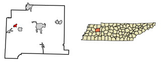
Benton County is a county located in the U.S. state of Tennessee. As of the 2020 census, the population was 15,864. Its county seat is Camden. The county was created in December 1835 and organized in 1836.

<span class="mw-page-title-main">Benton County, Arkansas</span> County in Arkansas, United States

Benton County is a county within the Northwest Arkansas region with a culture, economy, and history that have transitioned from rural and agricultural to suburban and white collar since the growth of Walmart, which is headquartered in Benton County. Created as Arkansas's 35th county on September 30, 1836, Benton County contains thirteen incorporated municipalities, including Bentonville, the county seat, and Rogers, the most populous city. The county was named after Thomas Hart Benton, a U.S. Senator from Missouri influential in Arkansas statehood.

<span class="mw-page-title-main">Hazel, Kentucky</span> City in Kentucky, United States

Hazel is a home rule-class city in Calloway County, Kentucky, United States. The population was 410 at the 2010 census.

<span class="mw-page-title-main">Hardin, Kentucky</span> City in Kentucky, United States

Hardin is a home rule-class city in Marshall County, Kentucky, United States. The population was 580 at the 2020 census.

<span class="mw-page-title-main">Camden, Tennessee</span> City in Tennessee, United States

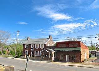
Camden is a city in Benton County, Tennessee. The population was 3,674 at the 2020 census. It is the county seat of Benton County.

<span class="mw-page-title-main">Huntingdon, Tennessee</span> Town in Tennessee, United States

Huntingdon is a town in Carroll County, Tennessee, United States. The population was 4,439 at the 2020 census and 3,985 in 2010. It is the county seat of Carroll County.

<span class="mw-page-title-main">Trezevant, Tennessee</span> Town in Tennessee, United States

Trezevant is a town in Carroll County, Tennessee. The population was 1,001 at the 2020 census and 959 at the 2010 census.

<span class="mw-page-title-main">Gibson, Tennessee</span> Town in Tennessee, United States

Gibson is a town in Gibson County, Tennessee, United States. The population was 396 at the 2010 census.

<span class="mw-page-title-main">Rutherford, Tennessee</span> Town in Tennessee, United States

Rutherford is a town in Gibson County, Tennessee, United States. At the 2000 census, its population was at 1,272 and in 2010 the population was 1,151.

<span class="mw-page-title-main">Cottage Grove, Tennessee</span> Town in Tennessee, United States

Cottage Grove is a town in Henry County, Tennessee, United States. The population was 88 at the 2010 census. Cottage Grove is currently the smallest town in Tennessee.

<span class="mw-page-title-main">Henry, Tennessee</span> Town in Tennessee, United States

Henry is a town in Henry County, Tennessee. The population was 520 at the 2000 census and 464 at the 2010 census, showing decline of 56. Gospel singer Bobby Jones was born here.

<span class="mw-page-title-main">Waverly, Tennessee</span> City in Tennessee, United States

Waverly is a city in and the county seat of Humphreys County, Tennessee, United States. The population was 4,297 at the 2020 census.

<span class="mw-page-title-main">Obion, Tennessee</span> Town in Tennessee, United States

Obion is a town in Obion County, Tennessee, United States, along the Obion River. The population was 1,119 at the 2010 census. It is part of the Union City, TN–KY Micropolitan Statistical Area.

<span class="mw-page-title-main">Benton, Tennessee</span> Town in Tennessee, United States

Benton is a town in Polk County, Tennessee, United States. The population was 1,532 at the 2020 census. It is the county seat.

<span class="mw-page-title-main">Brighton, Tennessee</span> Town in Tennessee, United States

Brighton is a town in Tipton County, Tennessee, United States. The population was 2,735 at the 2010 census.

<span class="mw-page-title-main">Gleason, Tennessee</span> Town in Tennessee, United States

Gleason is a town in Weakley County, Tennessee, United States. The population was 1,445 at the 2010 census. The city holds an annual Tater Town Parade and festival in the fall. The girls High School basketball team, the Lady Bulldogs, won the State Championship in 1992, 1999 and 2007.

<span class="mw-page-title-main">Sharon, Tennessee</span> Town in Tennessee, United States

Sharon is a town in Weakley County, Tennessee, United States. The population was 988 at the 2000 census and 944 at the 2010 census.

<span class="mw-page-title-main">Weber City, Virginia</span> Town in Virginia, United States

Weber City is an incorporated town in Scott County, Virginia, United States. The population was 1,327 at the 2010 census. It is part of the Kingsport–Bristol (TN)–Bristol (VA) Metropolitan Statistical Area, which is a component of the Johnson City–Kingsport–Bristol, TN-VA Combined Statistical Area – commonly known as the "Tri-Cities" region.

<span class="mw-page-title-main">Milledgeville, Tennessee</span> Town in Tennessee, United States

Milledgeville is a town in Chester, Hardin, and McNairy counties, Tennessee, United States. The population was 265 at the 2010 census.

References

  1. "ArcGIS REST Services Directory". United States Census Bureau. Retrieved October 15, 2022.
  2. 1 2 "Census Population API". United States Census Bureau. Retrieved October 15, 2022.
  3. 1 2 "U.S. Census website". United States Census Bureau . Retrieved January 31, 2008.
  4. "US Board on Geographic Names". United States Geological Survey. October 25, 2007. Retrieved January 31, 2008.
  5. Tennessee Department of Economic and Community Development, Certified Population of Tennessee Incorporated Municipalities and Counties Archived June 30, 2014, at the Wayback Machine , State of Tennessee official website, July 14, 2011. Retrieved: December 6, 2013.
  6. "Early Benton County Settlements". www.tngenweb.org. Retrieved January 20, 2024.
  7. "US Gazetteer files: 2010, 2000, and 1990". United States Census Bureau. February 12, 2011. Retrieved April 23, 2011.
  8. "U.S. Climate Normals Quick Access – Station: Big Sandy, TN". National Oceanic and Atmospheric Administration. Retrieved February 27, 2023.
  9. "NOAA Online Weather Data – NWS Memphis". National Weather Service. Retrieved February 27, 2023.
  10. "Census of Population and Housing: Decennial Censuses". United States Census Bureau . Retrieved March 4, 2012.
  11. "Incorporated Places and Minor Civil Divisions Datasets: Subcounty Resident Population Estimates: April 1, 2010 to July 1, 2012". Population Estimates. U.S. Census Bureau. Archived from the original on June 11, 2013. Retrieved December 11, 2013.

36°14′03″N88°05′09″W / 36.234203°N 88.085869°W / 36.234203; -88.085869