Bigelow, Arkansas

Last updated

Bigelow, Arkansas
Perry County Arkansas Incorporated and Unincorporated areas Bigelow Highlighted 0505920.svg
Location of Bigelow in Perry County, Arkansas.
Coordinates: 34°59′57″N92°37′52″W / 34.99917°N 92.63111°W / 34.99917; -92.63111
Country United States
State Arkansas
County Perry
Area
[1]
  Total0.94 sq mi (2.43 km2)
  Land0.94 sq mi (2.43 km2)
  Water0.00 sq mi (0.00 km2)
Elevation
[2]
328 ft (100 m)
Population
 (2020)
  Total352
  Density375.67/sq mi (144.98/km2)
Time zone UTC-6 (Central (CST))
  Summer (DST) UTC-5 (CDT)
ZIP code
72016
Area code 501
FIPS code 05-05920
GNIS feature ID2405263 [2]

Bigelow is a town in Perry County, Arkansas, United States. Located in Central Arkansas near the confluence of the Fourche La Fave River and Arkansas River, the community was incorporated in 1905 as Esau. Based largely on the timber industry, the town grew until the lumber mills were closed in 1920. The population was 329 at the 2000 census.

Contents

History

Bigelow did not exist by its current name until 1911, as it was formerly known as "Esau"—a community a few miles southwest of the present Bridge that grew to border the edge of the small town of Fourche. In 1911, Fourche River Mill owner, N.P. Bigelow, built an elaborate white house of the best lumber on a hill above the town. He was elected mayor, and then gained permission from the state's General Assembly to change the name of Esau to Bigelow. It was at one time the biggest town in the county; a vote was taken to move the county seat from Perryville to Bigelow, Bigelow won the vote, but the move was never made.

Geography

Bigelow is located at 34°59′57″N92°37′52″W / 34.99917°N 92.63111°W / 34.99917; -92.63111 (34.999061, -92.631203). [3]

According to the United States Census Bureau, the town has a total area of 0.8 square miles (2.1 km2), all land.

Demographics

Historical population
CensusPop.Note
1910 292
1920 1,589444.2%
1930 338−78.7%
1940 170−49.7%
1950 29271.8%
1960 231−20.9%
1970 25811.7%
1980 37344.6%
1990 340−8.8%
2000 329−3.2%
2010 315−4.3%
2020 35211.7%
U.S. Decennial Census [4]
2014 Estimate [5]

As of the census [6] of 2000, there were 329 people, 127 households, and 91 families residing in the town. The population density was 391.5 inhabitants per square mile (151.2/km2). There were 144 housing units at an average density of 171.3 per square mile (66.1/km2). The racial makeup of the town was 97.57% White, 0.61% Black or African American, 0.91% Native American, 0.61% Asian, and 0.30% from two or more races. 2.43% of the population were Hispanic or Latino of any race.

There were 127 households, out of which 33.9% had children under the age of 18 living with them, 55.9% were married couples living together, 12.6% had a female householder with no husband present, and 27.6% were non-families. 24.4% of all households were made up of individuals, and 16.5% had someone living alone who was 65 years of age or older. The average household size was 2.59 and the average family size was 3.05.

In the town, the population was spread out, with 28.3% under the age of 18, 8.8% from 18 to 24, 27.1% from 25 to 44, 22.2% from 45 to 64, and 13.7% who were 65 years of age or older. The median age was 36 years. For every 100 females, there were 89.1 males. For every 100 females age 18 and over, there were 85.8 males.

The median income for a household in the town was $32,000, and the median income for a family was $47,750. Males had a median income of $27,500 versus $21,429 for females. The per capita income for the town was $16,574. About 11.0% of families and 18.0% of the population were below the poverty line, including 32.1% of those under age 18 and 22.2% of those age 65 or over.

Education

The school district for public education for elementary and secondary school students is the East End School District, [7] which leads to graduation from Bigelow High School.

See also

Related Research Articles

<span class="mw-page-title-main">Pulaski County, Arkansas</span> County in Arkansas, United States

Pulaski County is a county in the U.S. state of Arkansas. With a population of 399,125 as of the 2020 United States Census, it is the most populous county in Arkansas. The county is included in the Little Rock–North Little Rock–Conway metropolitan area. Its county seat is Little Rock, which is also Arkansas's capital and largest city.

<span class="mw-page-title-main">Perry County, Arkansas</span> County in Arkansas, United States

Perry County is a county located in the U.S. state of Arkansas. Its population was 10,019 at the 2020 United States Census. The county seat is Perryville. The county was formed on December 18, 1840, and named for Commodore Oliver Hazard Perry, naval hero in the War of 1812. It is an alcohol prohibition or dry county.

<span class="mw-page-title-main">Hampton, Arkansas</span> Town in Arkansas, United States

Hampton is a town in Calhoun County, Arkansas, United States. The population was 1,181 according to the 2020 United States Census. The town is the county seat of Calhoun County.

<span class="mw-page-title-main">Carthage, Arkansas</span> Town in Arkansas, United States

Carthage is a town in Dallas County, Arkansas, United States. The population was 343 at the 2010 census.

<span class="mw-page-title-main">Enola, Arkansas</span> Town in Arkansas, United States

Enola is a town in Faulkner County, Arkansas, United States. It is part of the Central Arkansas region. The population was 318 at the 2020 census.

<span class="mw-page-title-main">Fountain Lake, Arkansas</span> Town in Arkansas, United States

Fountain Lake is a town in Garland County, Arkansas, United States. Bordering Hot Springs Village, the town is part of the Hot Springs Metropolitan Statistical Area. The population was 503 at the 2010 census.

<span class="mw-page-title-main">Lonsdale, Arkansas</span> Town in Arkansas, United States

Lonsdale is a town in Garland County, Arkansas, United States. It is part of the Hot Springs Metropolitan Statistical Area. The population was 103 at the 2020 census.

<span class="mw-page-title-main">Poyen, Arkansas</span> Town in Arkansas, United States

Poyen is a town in Grant County, Arkansas, United States. The population was 290 at the 2010 census. It is part of the Central Arkansas region.

<span class="mw-page-title-main">Tull, Arkansas</span> Town in Arkansas, United States

Tull is a town in Grant County, Arkansas, United States. The population was 448 at the 2010 census, up from 358 in 2000. It is part of the Central Arkansas region.

<span class="mw-page-title-main">Donaldson, Arkansas</span> Town in Arkansas, United States

Donaldson is a town in Hot Spring County, Arkansas, United States. The population was 301 at the 2010 census.

<span class="mw-page-title-main">Perla, Arkansas</span> Town in Arkansas, United States

Perla is a town in Hot Spring County, Arkansas, United States. The population was 241 at the 2010 census, up from 115 at the 2000 census. The city's water association filed for Chapter 9 Bankruptcy in the Western District of Arkansas Bankruptcy Court on May 26, 2019.

<span class="mw-page-title-main">Keo, Arkansas</span> Town in Arkansas, United States

Keo is a town in southwest Lonoke County, Arkansas, United States. The population was 256 at the 2010 census. It is part of the Little Rock–North Little Rock–Conway Metropolitan Statistical Area.

<span class="mw-page-title-main">Fourche, Arkansas</span> Town in Arkansas, United States

Fourche is a town in Perry County, Arkansas, United States. The population was 59 at the 2000 census. It is part of the Little Rock–North Little Rock–Conway Metropolitan Statistical Area.

<span class="mw-page-title-main">Alexander, Arkansas</span> City in Arkansas, United States

Alexander is a city in Pulaski and Saline counties in the U.S. state of Arkansas. Located in Central Arkansas, the town was founded as a construction camp for the nearby railroad. Following its completion, the citizens decided to incorporate in 1887. Alexander is home to the Arkansas Juvenile Assessment and Treatment Center. The population was 2,901 at the 2010 census.

<span class="mw-page-title-main">Sweet Home, Arkansas</span> Census-designated place in Pulaski County, Arkansas, USA

Sweet Home is a census-designated place (CDP) in Pulaski County, Arkansas, United States. Its population was 849 at the 2010 census. It is part of the 'Little Rock-North Little Rock-AR Metropolitan Statistical Area'.

<span class="mw-page-title-main">Bryant, Arkansas</span> City in Arkansas, United States

Bryant is a city in Saline County, Arkansas, United States and a suburb of Little Rock. According to the 2010 Census, the population of the city was 16,688. It is part of the Central Arkansas region.

<span class="mw-page-title-main">Salem, Saline County, Arkansas</span> CDP in Arkansas, United States

Salem is a census-designated place (CDP) in Saline County, Arkansas, United States. Per the 2020 census, the population was 2,544. It is part of the Little Rock–North Little Rock–Conway Metropolitan Statistical Area.

<span class="mw-page-title-main">Shirley, Arkansas</span> Town in Arkansas, United States

Shirley is a town in northeast Van Buren County, Arkansas, United States, along the Middle Fork of the Little Red River. A one-time railroad outpost, the community today is oriented toward agriculture and recreational activities due to the river and Greers Ferry Lake. The population was 223 at the 2010 census.

<span class="mw-page-title-main">Ashland, Maine</span> Town in Maine, United States

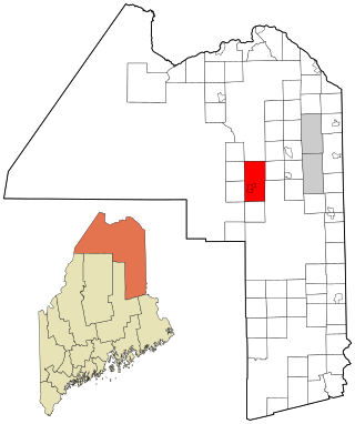
Ashland is a town in Aroostook County, Maine, United States. The population was 1,202 at the 2020 census.

<span class="mw-page-title-main">South Gate, Maryland</span> Former census-designated place in Maryland, United States

South Gate was a census-designated place (CDP) in Anne Arundel County, Maryland, United States, for the 2000 census, at which time its population was 28,672. It was added primarily to the Glen Burnie CDP for the 2010 census.

References

  1. "2020 U.S. Gazetteer Files". United States Census Bureau. Retrieved October 29, 2021.
  2. 1 2 U.S. Geological Survey Geographic Names Information System: Bigelow, Arkansas
  3. "US Gazetteer files: 2010, 2000, and 1990". United States Census Bureau. February 12, 2011. Retrieved April 23, 2011.
  4. "Census of Population and Housing". Census.gov. Retrieved June 4, 2015.
  5. "Annual Estimates of the Resident Population for Incorporated Places: April 1, 2010 to July 1, 2014". Archived from the original on May 22, 2015. Retrieved June 4, 2015.
  6. "U.S. Census website". United States Census Bureau . Retrieved January 31, 2008.
  7. "2020 CENSUS - SCHOOL DISTRICT REFERENCE MAP: Perry County, AR" (PDF). U.S. Census Bureau . Retrieved October 16, 2022.