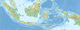
West Papua, formerly Irian Jaya Barat, is an Indonesian province located in Indonesia Papua. It covers most of the two western peninsulas of the island of New Guinea, the eastern half of the Bird's Head Peninsula and the whole of the Bomberai Peninsula, along with nearby smaller islands. The province is bordered to the north by the Pacific Ocean, to the west by Southwest Papua Province, the Halmahera Sea and the Ceram Sea, to the south by the Banda Sea, and to the east by the province of Central Papua and the Cenderawasih Bay. Manokwari is the province's capital and largest city. With an estimated population of 569,570 in mid-2023, West Papua is the least populous province in Indonesia after South Papua, following the separation off in 2022 of the western half of the Bird's Head Peninsula to create the new province of Southwest Papua, containing 52% of what had been West Papua's population.Its population density is similar to Russia.

Western New Guinea, also known as Papua, Indonesian New Guinea, and Indonesian Papua, is the western half of the island of New Guinea, formerly Dutch and granted to Indonesia in 1962. Given the island is alternatively named Papua, the region is also called West Papua.

Cenderawasih Bay, also known as Sarera Bay and formerly Geelvink Bay, is a large bay in northern Province of Papua, Central Papua and West Papua, New Guinea, Indonesia.

The Arfak Mountains is a mountain range found on the Bird's Head Peninsula in the Province of West Papua, Indonesia.
Sougb, or Sogh, is a Papuan language of the East Bird's Head language family spoken in the east of the Bird's Head Peninsula to the east of Meyah and to the south of Manokwari, including the area of Soug Jaya District, Teluk Wondama Regency. It consists of four dialects and is spoken by around 12,000 people in all. The language is alternatively known as Mantion, or Manikion, an originally derogatory term used by the Biak people.
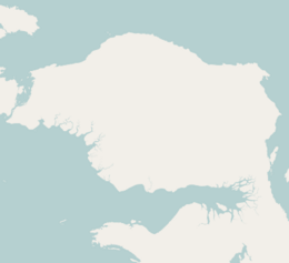
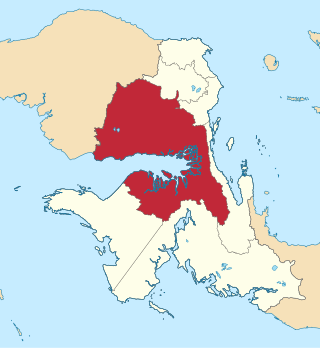
Bomberai Peninsula is located in the Western New Guinea region. It is south of the Bird's Head Peninsula, and Bintuni Bay separates the two peninsulas. To the west lies the Sebakor Bay and to the south Kamrau Bay. On the southeast Arguni Bay lies between the peninsula and the Bird's Neck Isthmus.

New Guinea is the world's second-largest island, with an area of 785,753 km2 (303,381 sq mi). Located in Melanesia in the southwestern Pacific Ocean, the island is separated from Australia by the 150-kilometre wide Torres Strait, though both landmasses lie on the same continental shelf, and were united during episodes of low sea level in the Pleistocene glaciations as the combined landmass of Sahul. Numerous smaller islands are located to the west and east. The island's name was given by Spanish explorer Yñigo Ortiz de Retez during his maritime expedition of 1545 due to the resemblance of the indigenous peoples of the island to those in the African region of Guinea.

Bintuni Bay is the eastward extension or inner bay of Berau Gulf in western New Guinea. It separates the Bird's Head Peninsula on the north from the Bomberai Peninsula on the south. Administratively it is part of West Papua, Indonesia. The bay is 12 miles (19.3 km) wide at its entrance and there are extensive marshes along the shore.
The Pegunungan Arfak Nature Reserve lies in the north-east corner of the Bird's Head Peninsula in the Indonesian province of West Papua. It is located 25 km south of the provincial capital Manokwari. It spans from near the coast up to the highest point in the province, Pegunungan Arfak, at 2,955 m (9,695 ft).
New Guinea, lying within the tropics and with extensive mountain areas, comprises a wide range of ecoregions. These include rainforests, grasslands and mangrove.
Teluk Bintuni Regency or Bintuni Bay Regency is a regency of West Papua Province of Indonesia. It covers an area of 18,637 km2, comprising administrative districts on three sides of Bintuni Bay, a gulf that separates the Bird's Head Peninsula and Bomberai Peninsula which together form the main geographical constituents of the province; it had a population of 52,422 at the 2010 Census and 87,083 at the 2020 Census; the official estimate as at mid 2023 was 90,101. The administrative centre is the town of Bintuni.

Mount Arfak is the highest point in the province of West Papua. It is located on north-east side of the Bird's Head Peninsula. It is a popular hiking area and is the highest peak of the Arfak Mountains. From the summit, Manokwari can be seen. The summit of Mt. Arfak is temperate and dry with very hot, dry summer temperatures that average below 95 °F (35 °C) and mild, humid winter temperatures that average above 38 °F (3 °C). During the winter months, the mountain's summit receives frost usually and sometimes can get to 33 °F (0 °C) every now and then. Sometimes snow can fall on the summit, but not every year. Average rain amount per year is about 45 inches (1150 mm). The mountain is part of the Pegunungan Arfak Nature Reserve, a 683-square-kilometer (264 sq mi) protected area that protects parts of the Vogelkop montane rain forests ecoregion. The mountain is also the highest point in the Manokwari metropolitan area.

The Tamrau Mountains, also known as the Tambrauw Mountains or the Tamarau Mountains, is a mountain range located in the north-central region of the Bird's Head Peninsula in the province of West Papua, Indonesia. It is made up of an isolated and lesser continuous mountain chain compared to the Arfak Mountains. The Tamrau and Arfak Mountains are both divided by the grassy Kebar Valley, which is the heartland of many indigenous people, with a variety of backgrounds. The Tamrau Mountains have been scantily surveyed. The mountains are an important and threatened site of biodiversity, part of the Vogelkop montane rain forests ecoregion.
Bon Irau, with an elevation of 2,501 metres (8,205 ft), is the highest peak in the Tamrau Mountains and the highest point in the province of West Papua outside of the Arfak Mountains. It is located in the north central region of the Bird's Head Peninsula and located around 20 kilometres (12 mi) from the grassy Kebar Valley.

The Kebar Valley is a large pleistocene/holocene intermontane valley found in the north central region of the Bird's Head Peninsula in the province of Southwest Papua. The valley is enclosed by the fault-bounded Tamrau Mountains at an area of 2,703 square kilometres (1,044 sq mi). Its depth averages from 500 to 600 m in the lower sections to around 900 to 1,400 m in the upper sections of the valley. The valley is located 130 km (81 mi) west of Manokwari and 190 km (120 mi) east of Sorong. The nearest major village to the valley is Saukorem. A notable path runs through the Kebar Valley connecting Saukorem to the settlement of Andai and reaches an altitude of 1,200 m (3,900 ft). This has created many villages throughout the area, leading to a growing rice production in the central and eastern regions of the valley. From north to south, the Kebar Valley ranges from 16 to 30 km wide, and from east to west, it extends from 94 to 116 km in length.

The Berau Gulf, formerly the MacCleur Gulf, separates the Vogelkop (Doberai) and Bomberai Peninsulas of Western New Guinea. It opens on the Ceram Sea to the west and ends in Bintuni Bay to the east.

The Vogelkop–Aru lowland rain forests is a tropical moist forest ecoregion in Indonesia. The ecoregion covers the peninsular lowlands of western New Guinea, along with the Aru Islands and other nearby islands.
The Vogelkop montane rain forests is a tropical moist forest ecoregion in western New Guinea. The ecoregion covers the mountains of western New Guinea's Bird's Head and Bomberai peninsulas.

Southwest Papua is the 38th province of Indonesia to be created, and was split off from West Papua on 8 December 2022. Despite being named southwest, it is a misnomer and this province is actually located in the northwest edge of Papua. The province comprises the Greater Sorong area which consists of Sorong City, Sorong Regency, South Sorong Regency, Maybrat Regency, Tambrauw Regency, and Raja Ampat Regency. The Bill (RUU) on the Establishment of the Southwest Papua Province was passed into law and therefore it became the 38th province in Indonesia with effect from 8 December 2022.
The Bird's Neck Isthmus is an isthmus in western New Guinea. It connects the main mass of the island to its two large western peninsulas, the Bird's Head Peninsula, also known as the Vogelkop or Doberai Peninsula, and the Bomberai Peninsula. The isthmus is mostly covered in lowland tropical rain forest.