New Guinea mangroves

Last updated
New Guinea mangroves
Mangroves, Papua New Guinea.jpg
New Guinea mangroves
Ecoregion AA1401.svg
Location of the New Guinea mangroves (in purple)
Ecology
Realm Australasian realm
Biome mangroves
Borders
Geography
Area25,303 km2 (9,770 sq mi)
Countries
Provinces
Coordinates 5°06′S137°42′E / 5.1°S 137.7°E / -5.1; 137.7
Conservation
Conservation status Vulnerable
Protected5,833 km² (23%) [1]

The New Guinea mangroves is a mangrove ecoregion that covers extensive areas of the coastline New Guinea, the large island in the western Pacific Ocean north of Australia. [2] [3] [4]

Contents

Location and description

The New Guinea mangroves cover an area of 26,800 square kilometers (10,300 sq mi), particularly among the river mouths of the island's south coast. This ecoregion contains the greatest diversity of mangrove species in the world and they are an important habitat for wildlife. Areas of mangroves on the northern coast of New Guinea can be found at the mouths of the Sepik and Ramu rivers on the eastern side of Cenderawasih Bay, and Dyke Ackland Bay and Ward Hunt Strait. However the largest areas are found on the south coast, including in the mouths of the Purari, Kikori, and Fly rivers. Some areas such as the Kikori delta have larger and thicker mangroves than others. Bintuni Bay in western New Guinea, which lies between the Bird's Head and Bomberai peninsulas, contains the largest continuous area of mangroves in Indonesia, and is second only to the Sundarbans of India and Bangladesh. [5]

Climate

The coast of New Guinea has a Tropical monsoon climate apart from the length of drier Trans-Fly savanna and grasslands coastline on the south coast.

The growth of mangroves

Mangroves depend on a complex series of dynamic natural tidal processes that create the conditions for their survival. Rivers depositing sediment, together with waves and coastal currents, reshape the tidal zone where mangroves thrive. There are several features that all species of mangroves have in common. These include tolerance to conditions of high soil salinity, tolerance to submergence in water, or waterlogged soil, and to low oxygen conditions. The use of water to disperse young plants is also very characteristic of mangroves. [6] As a result of the water-logged soil that mangrove trees reside in, they have formed adaptations to help them survive. For example, black mangroves survive in water-logged soil by using special "root snorkels" called pneumatophores. These structures are covered with small holes call lenticels that allow the roots to breathe the same way a snorkel lets you breathe while underwater. [7] When trying to overcome the obstacle of the salinity that these trees live in, they have a few adaptations. They can actually concentrate much of the salt concentration in older leaves, which are soon to fall off, taking the excess salt with them. Some species even have salt glands which excrete salt to the surface of the leaves allowing it to be washed away by rain. [8]

Mangroves begin as a seed called a propagule, which germinates while still attached to the tree. The seed has a long cylindrical shape that falls off the parent tree and either sticks in the mud growing next to the parent tree, or floats off to sea. These seeds have a very strong, protective covering that allows them to float and survive for long distances and periods of time. The seedling may finally reach a point of its destination where conditions are favorable, and the roots will begin to bury into the ground, forming a new mangrove tree. [9] The dispersal of these "live" young trees is called vivipary, or birth of live young, very similar to mammals. [10]

Flora

The range of newly deposited and well-established areas, varying water depth, and variations in salinity from the mixing of salt and fresh water create a diversity of habitats that are home to different mixes of species. On the shoreline pioneering species like the Avicennia species Avicennia alba and Avicennia marina are usually the first to establish on coastal shores, with Sonneratia growing in the coastal tidal creeks. Their complex root networks encourage further sedimentation and growth which then creates shade that allows Rhizophora mucronata to establish itself, ultimately supplanting the shade-intolerant Avicennia and Sonneratia. Then Rhizophora apiculata and Bruguiera parviflora , (and occasionally Bruguiera gymnorhiza ) are the next in succession but still in waters that are more than 10% saline. Mature mangrove forests include Xylocarpus , Lunmitzera, and Heritiera. Papuan mahogany Xylocarpus granatum can form monotypic stands, reaching up to 20 meters in height, with buttressed trunks up to a meter across.

Where freshwater flows create a less salty brackish environment the mangrove palm Nypa fruticans is common, together with Xylocarpus granatum and Heritiera littoralis . Mangrove forests bordering freshwater swamp forests include Bruguiera sexangula , Camptostemon schultzii , Dolichandrone spathacea , Diospyros spp., Excoecaria agallocha , Heritiera littoralis , Rhizophora apiculata , and Xylocarpus granatum , along with typical freshwater swamp forest species, such as Calophyllum spp., Kwila ( Intsia bijuga ), Myristica hollrungii , and Amoora cucullata .

Over 30 species of mangroves have been recorded in Bintuni Bay, and undisturbed mangrove stands can grow up to 30 metres tall. [11]

Fauna

These continuously changing woodlands do not have a great variety of mammals, although the greater sheath-tailed bat (Emballonura furax) is a near-endemic. Many species of birds also inhabit these forests including the New Guinea flightless rail, while endemic or near-endemic birds include the red-billed brush-turkey, Wallace's fruit-dove, western crowned pigeon, Salvadori's fig parrot, black lory, brown lory, Papuan swiftlet, red-breasted paradise-kingfisher, white-bellied pitohui, and the olive-crowned flowerpecker. [12] Reptiles recorded from the New Guinea mangroves on Daru and Bobo (Bristow) Islands, Western Province, PNG, during survey work [ citation needed ] were the estuarine crocodile (Crocodylus porosus), littoral skink (Emoia atrocostata), mangrove monitor (Varanus indicus), amethystine python (Morelia amethistina), crab-eating mangrove snake (Fordonia leucobalia), and Richardson's mangrove snake (Myron richardsonii). All are species strongly associated with southern New Guinea mangroves.

Ecological importance

Mangrove forests act as a "natural cleaner". For example, they intercept land-derived nutrients, pollutants, and suspended matter before these contaminants reach deeper water. They also prevent coastal erosion by stabilizing sediments [13] provide nursery and spawning areas for commercially important fish [14] and provide stop over sites for organisms such as migratory birds, mammals, and fish. [15]

Threats and preservation

Even though this thick forest is hard to penetrate about 35% of the mangrove forests have been lost in the past two decades. These losses exceed those for tropical rain forests and coral reefs. Mangrove trees grow on a narrow strip between land and ocean in river systems, between the latitudes 25 degrees N and 30 degrees S, and the constant renewal of the trees relies on rivers bringing nutrients to the coast in regular seasonal patterns. The limited distribution of this ecosystem adds to the delicacy of it. Many global changes such as an increased rise in sea water is largely thought to be responsible for the destruction of these mangrove forests. A few other factors such as mariculture, agriculture, and urbanization have also contributed to the recent loss of mangrove habitats. Mangroves provide humans with shrimp, fish, honey, lumber, and reptile skins. Without this tropical habitat, many of these products would be reduced in our market. [16]

Threats to mangroves in Bintuni Bay and on Daru and Bobo (Bristow) Islands, Western Province, PNG, includes cutting for firewood and charcoal burning. Cutters travel by canoe up creeks into the interior of the mangrove forest and clear-fell large areas of trees which from the outside appear untouched. The timber is sold in the market on Daru, an island which is home to 10% of the Western Province population i.e. some 15,000 people including immigrants from Indonesian New Guinea (Papua). It is doubtful the mangrove forests can sustain this level of harvesting. Kwila ( Intsia bijuga ) and Papuan mahogany have more valuable timber and so are more vulnerable.

Many steps around the world are being taken in an effort to conserve mangrove forests from being completely wiped out. Some of these efforts include replanting of trees by local communities, and the development of sustainable use systems within a community. This practice includes using resources from mangroves that is at a rate in which the ecosystem can recover. [17] Meanwhile, there are four protected areas that include some coastal mangroves: Bintuni Bay Nature Reserve, Lorentz National Park and the Pulau Kimaam Wildlife Reserve in Indonesia and the Kikori Integrated Conservation and Development Project in Papua New Guinea.

Related Research Articles

<span class="mw-page-title-main">Sundarbans</span> Mangrove forest in the Bay of Bengal

Sundarbans is a mangrove area in the delta formed by the confluence of the Ganges, Brahmaputra and Meghna Rivers in the Bay of Bengal. Sundarban Reserve Forest (SRF) of Bangladesh is the largest mangrove forest in the world. It spans the area from the Baleswar River in Bangladesh's division of Khulna to the Hooghly River in India's state of West Bengal. It comprises closed and open mangrove forests, land used for agricultural purpose, mudflats and barren land, and is intersected by multiple tidal streams and channels. Sundarbans is home to the world's largest area of mangrove forests. Four protected areas in the Sundarbans are enlisted as UNESCO World Heritage Sites, viz. Sundarbans West (Bangladesh), Sundarbans South (Bangladesh), Sundarbans East (Bangladesh) and Sundarbans National Park (India).

<span class="mw-page-title-main">Nansei Islands subtropical evergreen forests</span> Terrestrial Ecoregion of the Ryukyu Islands

The Nansei Islands subtropical evergreen forests is a terrestrial ecoregion of the Ryukyu Islands, also known as the Nansei Islands, in Japan. The Nansei Islands are an island arc that stretches southwest from Kyushu towards Taiwan. The larger islands are mostly volcanic islands and the smaller ones mostly coral. The largest is Okinawa Island. The highest point is Mount Miyanoura on Yakushima Island at 1,936 metres.

<span class="mw-page-title-main">Coringa Wildlife Sanctuary</span> Sanctuary in Andhra Pradesh, India

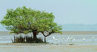
Coringa Wildlife Sanctuary is an estuary situated near Kakinada in Andhra Pradesh, India. It is the third largest stretch of mangrove forests in India with 24 mangrove tree species and more than 120 bird species. It is home to the critically endangered white-backed vulture and the long billed vulture. Mangroves are a group of trees and shrubs that live in the coastal intertidal zone, with a dense tangle of prop roots that make the trees appear to be standing on stilts above the water. This tangle of roots allows the trees to handle the daily rise and fall of tides; hence, the mangrove forest gets flooded at least twice per day. The roots also slow the movement of tidal waters, causing sediments to settle out of the water and build up the muddy bottom.

<span class="mw-page-title-main">Godavari–Krishna mangroves</span> Mangrove ecoregion of Indias eastern coast

The Godavari–Krishna mangroves are a mangrove ecoregion of India's eastern coast.

<span class="mw-page-title-main">Ao Phang Nga National Park</span> Marine protected area in southern Thailand

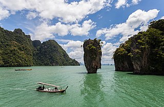
Ao Phang Nga National Park, located in the Phang Nga Province of the Southern Thailand, encompasses parts of Mueang Phang Nga District and Takua Thung District. The park is predominantly maritime, featuring a section of the Strait of Malacca dotted with numerous limestone tower karst islands. Among these islands, Khao Phing Kan stands out as particularly well-known, having gained the nickname 'James Bond Island' due to its use as a filming location for the James Bond film The Man with the Golden Gun.

<span class="mw-page-title-main">Central African mangroves</span> Largest area of mangrove swamp in Africa, located on the coasts of West Africa, mainly in Nigeria

The Central African mangroves ecoregion consists of the largest area of mangrove swamp in Africa, located on the coasts of West Africa, mainly in Nigeria.

<span class="mw-page-title-main">Guinean mangroves</span> Coastal tidal mangrove swamp ecoregion on West African coast

The Guinean mangroves are a coastal ecoregion of mangrove swamps in rivers and estuaries near the ocean of West Africa from Senegal to Sierra Leone.

<span class="mw-page-title-main">Madagascar mangroves</span> Coastal ecoregion in the mangrove forest biome found on the west coast of Madagascar

Madagascar mangroves are a coastal ecoregion in the mangrove forest biome found on the west coast of Madagascar. They are included in the WWF's Global 200 list of most outstanding ecoregions.

<span class="mw-page-title-main">Southern Africa mangroves</span> Ecoregion of mangrove swamps in rivers and estuaries on the eastern coast of South Africa

The Southern Africa mangroves are mangrove ecoregion on the Mozambique's southernmost coast and the eastern coast of South Africa.

<span class="mw-page-title-main">Sunda Shelf mangroves</span> Mangrove ecoregion in Southeast Asia

The Sunda Shelf mangroves ecoregion, in the mangrove biome, are on the coasts of the islands of Borneo and eastern Sumatra in Malaysia and Indonesia. They are home to the proboscis monkey.

<span class="mw-page-title-main">Ngezi Forest Reserve</span> Forest Reserve in North Pemba Region, Tanzania

The Ngezi Forest Reserve is a forest reserve located on Micheweni District of North Pemba Region on Pemba Island, Tanzania. It covers an area of 1,440 hectares, mostly comprising primary forest. The reserve was established in 1959.

<i>Xylocarpus granatum</i> Species of mangrove in the mahogany family

Xylocarpus granatum, commonly known as the cannonball mangrove, cedar mangrove, or puzzlenut tree, is a species of mangrove in the mahogany family (Meliaceae). It is found in Africa, Asia, Australasia and the Pacific Islands. It is a common species of mangrove, and the International Union for Conservation of Nature has assessed its conservation status as being of "least concern".

<span class="mw-page-title-main">Amapá mangroves</span> Ecoregion in Amapá, Brazil

The Amapá mangroves (NT1402) is an ecoregion along the Atlantic coast of the state of Amapá in Brazil. The low coastal plain has been formed from recent sedimentation, including sediments deposited by the rivers and sediments carried northward from the mouth of the Amazon River by strong currents and deposited by the tides. The extensive mangroves grow on the newly formed coastal mudflats and along the edges of estuaries. They merge into freshwater várzea flooded forests further inland. The ecoregion is generally well-preserved, although excessive extraction of natural resources including timber and shrimps is a concern.

<span class="mw-page-title-main">Pará mangroves</span> Mangrove ecoregion in Northern Brazil

The Pará mangroves (NT1427) is an ecoregion along the Atlantic coast of the state of Pará in Brazil. They constitute the western extension of the Maranhão mangroves ecoregion. The mangroves are relatively intact, although they are under some pressure from agriculture and logging.

<span class="mw-page-title-main">Abatan River</span> Waterway in Bohol, Philippines

The Abatan River is a river in western Bohol, Philippines. The river winds through the towns of Catigbian, Antequera, Balilihan, and Maribojoc to its mouth at Cortes.

<span class="mw-page-title-main">Tongan tropical moist forests</span>

The Tongan tropical moist forests is a tropical and subtropical moist broadleaf forests ecoregion that includes the Tonga archipelago and Niue.

<span class="mw-page-title-main">Gulf of Fonseca mangroves</span> Ecoregion in Central America

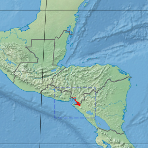
The Gulf of Fonseca mangroves ecoregion covers the brackish mangrove forests around the Gulf of Fonseca on the Pacific Ocean. The Gulf is the meeting point El Salvador, Honduras, and Nicaragua. The Gulf is one of the two primary nesting sites of the critically endangered Hawksbill turtle in the eastern Pacific. In the Honduras portion, there are seven nature reserves that collectively make up a RAMSAR wetland of international importance, providing protection for migratory birds, sea turtle, and fish.

<span class="mw-page-title-main">Moist Pacific Coast mangroves</span> Ecoregion in Costa Rica and Panama

The Moist Pacific Coast mangroves ecoregion covers a series of disconnected mangrove sites along the Pacific Ocean coast of Costa Rica and Panama. These sites occur mostly on coastal flatlands around lagoons, particularly where rivers from the inland mountains reach the sea, bringing fresh water to the coastal forests. The area is in a transition zone from the drier coastline to the north; rainfall in this ecoregions is over 2,000 mm/year, and reaches over 3,600 mm/year at the southern end.

<span class="mw-page-title-main">Rio Negro–Rio San Sun mangroves</span>

The Rio Negro-Rio San Sun mangroves ecoregion covers a series of small of discontinuous mangrove forests on the Caribbean Sea coast of Costa Rica, from a small portion inside the border with Nicaragua in the west to the border with Panama in the east. The coast on this stretch is a flat, alluvial plain, and mangroves are only a small part of a diverse patchwork of local habitats including swamps, mixed rainforests, coastal lagoons, sea grass beds, and sandy beaches. Much of the territory is "blackwater river" in character - slow-moving channels in wooded swamps with water stained by decayed matter. These mangroves are periodically damaged by hurricanes, such as in 1988 from Hurricane Joan, but are able to regenerate.

<span class="mw-page-title-main">Trinidad mangroves</span> Ecoregion in Trinidad

The Trinidad mangroves ecoregion covers the separate mangrove forest areas on the coast of the island of Trinidad, in the country of Trinidad and Tobago. The character of the mangroves is affected by the large amount of fresh water flowing out of the Orinoco River and Amazon River to the south, which flow northwest around the island. The mangroves of Trinidad are found on all coasts, and are usually in the estuaries of rivers, but also found in coastal lagoons.

References

  1. Eric Dinerstein, David Olson, et al. (2017). An Ecoregion-Based Approach to Protecting Half the Terrestrial Realm, BioScience, Volume 67, Issue 6, June 2017, Pages 534–545; Supplemental material 2 table S1b.
  2. "Map of Ecoregions 2017". Resolve. Retrieved August 20, 2021.
  3. "New Guinea mangroves". Digital Observatory for Protected Areas. Retrieved August 20, 2021.
  4. "New Guinea mangroves". The Encyclopedia of Earth. Retrieved August 20, 2021.
  5. Murdiyarso, D., Sasmito, S.D., Sillanpää, M. et al. Mangrove selective logging sustains biomass carbon recovery, soil carbon, and sediment. Sci Rep 11, 12325 (2021). https://doi.org/10.1038/s41598-021-91502-x
  6. "Mangrove Swamps." U.S. Environmental Protection Agency 21 Oct 2008 Web.12 Apr 2009. <http://www.epa.gov/owow/wetlands/types/mangrove.html>.
  7. "Mangrove Swamps." U.S. Environmental Protection Agency 21 Oct 2008 Web.12 Apr 2009. <http://www.epa.gov/owow/wetlands/types/mangrove.html>.
  8. "Plant Diversity-Mangroves." Wet Tropics Management Authority 2002-2006 Web.12 Apr 2009. <http://www.wettropics.gov.au/pa/pa_mangroves.html Archived 2011-10-10 at the Wayback Machine >.
  9. Maikut, Diana. "Ecology of Mangroves." 04 Jun 2004 Web.12 Apr 2009.<http://jrscience.wcp.muohio.edu/fieldcourses04/PapersMarineEcologyArticles/EcologyofMangroves.html>.
  10. Maikut, Diana. "Ecology of Mangroves." 04 Jun 2004 Web.12 Apr 2009. <http://jrscience.wcp.muohio.edu/fieldcourses04/PapersMarineEcologyArticles/EcologyofMangroves.html>.
  11. Sasmito SD, Sillanpää M, Hayes MA, et al. Mangrove blue carbon stocks and dynamics are controlled by hydrogeomorphic settings and land-use change. Glob Change Biol. 2020; 26: 3028–3039. https://doi.org/10.1111/gcb.15056
  12. "New Guinea Mangroves". Terrestrial Ecoregions. World Wildlife Fund. Retrieved 12 Apr 2009.
  13. Valiela, Ivan, Bowen, Jennifer, York, Joanna. "Mangrove Forests: One of the World's Threatened Major Tropical Environments." American Institute of Biological Sciences 2001 807-815. doi : 10.1641/0006-3568(2001)051[0807:MFOOTW 2.0.CO;2].
  14. Valiela, Ivan, Bowen, Jennifer, York, Joanna . "Mangrove Forests: One of the World's Threatened Major Tropical Environments." American Institute of Biological Sciences 2001 807-815. doi : 10.1641/0006-3568(2001)051[0807:MFOOTW 2.0.CO;2]
  15. Valiela, Ivan, Bowen, Jennifer, York, Joanna. "Mangrove Forests: One of the World's Threatened Major Tropical Environments." American Institute of Biological Sciences 2001 807-815. doi : 10.1641/0006-3568(2001)051[0807:MFOOTW 2.0.CO;2].
  16. Valiela, Ivan, Bowen, Jennifer, York, Joanna. "Mangrove Forests: One of the World's Threatened Major Tropical Environments." American Institute of Biological Sciences 2001 807-815. doi : 10.1641/0006-3568(2001)051[0807:MFOOTW 2.0.CO;2]
  17. Maikut, Diana. "Ecology of Mangroves." 04 Jun 2004 Web.12 Apr 2009. <http://jrscience.wcp.muohio.edu/fieldcourses04/PapersMarineEcologyArticles/EcologyofMangroves.html>.
New Guinea mangroves New Guinea
Australian mangroves Australia