Related Research Articles

The Peenemünde Army Research Center was founded in 1937 as one of five military proving grounds under the German Army Weapons Office (Heereswaffenamt). Several German guided missiles and rockets of World War II were developed by the HVP, including the V-2 rocket. The works were attacked by the British in Operation Crossbow from August 1943, before falling to the Soviets in May 1945.

Edwards Air Force Base (AFB) is a United States Air Force installation in California. Most of the base sits in Kern County, but its eastern end is in San Bernardino County and a southern arm is in Los Angeles County. The hub of the base is Edwards, California. The base was named after World War II USAAF veteran and test pilot Capt. Glen Edwards in 1950; prior to then the facility was named Muroc Air Force Base.
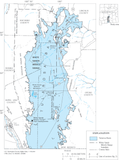
White Sands Missile Range (WSMR) is a United States Army military testing area and firing range located in the US state of New Mexico. The range was originally established as the White Sands Proving Ground on 9 July 1945. White Sands National Park is located within the range.

The Four Corners is a region of the Southwestern United States consisting of the southwestern corner of Colorado, southeastern corner of Utah, northeastern corner of Arizona, and northwestern corner of New Mexico. The Four Corners area is named after the quadripoint at the intersection of approximately 37° north latitude with 109° 03' west longitude, where the boundaries of the four states meet, and are marked by the Four Corners Monument. It is the only location in the United States where four states meet. Most of the Four Corners region belongs to semi-autonomous Native American nations, the largest of which is the Navajo Nation, followed by Hopi, Ute, and Zuni tribal reserves and nations. The Four Corners region is part of a larger region known as the Colorado Plateau and is mostly rural, rugged, and arid. In addition to the monument, commonly visited areas within Four Corners include Monument Valley, Mesa Verde National Park, Chaco Canyon, Canyons of the Ancients National Monument and Canyon de Chelly National Monument. The most populous city in the Four Corners region is Farmington, New Mexico, followed by Durango, Colorado.

The PGM-19 Jupiter was the first nuclear armed, medium-range ballistic missile (MRBM) of the United States Air Force (USAF). It was a liquid-propellant rocket using RP-1 fuel and LOX oxidizer, with a single Rocketdyne LR79-NA rocket engine producing 667 kilonewtons (150,000 lbf) of thrust. It was armed with the 1.44 megatons of TNT (6.0 PJ) W49 nuclear warhead. The prime contractor was the Chrysler Corporation.
Black Mesa may refer to:

The M270 Multiple Launch Rocket System is an American armored, self-propelled, multiple rocket launcher.

The Krupp K5 was a heavy railway gun used by Germany throughout World War II.

The MGR-1 Honest John rocket was the first nuclear-capable surface-to-surface rocket in the United States arsenal. Originally designated Artillery Rocket XM31, the first unit was tested on 29 June 1951, with the first production rounds delivered in January 1953. Its designation was changed to M31 in September 1953. The first Army units received their rockets by year's end and Honest John battalions were deployed in Europe in early 1954. Alternatively, the rocket was capable of carrying an ordinary high-explosive warhead weighing 1,500 pounds (680 kg).

The WAC Corporal was the first sounding rocket developed in the United States and the first vehicle to achieve hypersonic speeds. It was an offshoot of the Corporal program, that was started by a partnership between the United States Army Ordnance Corps and the California Institute of Technology in June 1944 with the ultimate goal of developing a military ballistic missile.
The Naval Aviation Ordnance Test Station (NAOTS) was a United States Navy base located at 37°55′N75°22′W, near Chincoteague, VA, that was used as a suborbital launch site. In 1955, research rockets of the Rockair type were launched from F2H-2 planes based there. An altitude of 54,864 m was reached with a 70mm (2.75-in.) folded-fin aerial rocket (FFAR) of Korean vintage. In spite of successful tests, the rockair concept never achieved the popularity of the rockoon. Apparently no important scientific rocket research was carried out with rockaires, in contrast to the hundreds of rockoons fired during the 1950s.

The geography of the U.S. State of Colorado is diverse, encompassing both rugged mountainous terrain, vast plains, desert lands, desert canyons, and mesas. Colorado is a landlocked U.S. state. In 1861, the United States Congress defined the boundaries of the new Territory of Colorado exclusively by lines of latitude and longitude, stretching from 37°N to 41°N latitude, and from 102°02'48"W to 109°02'48"W longitude. Starting in 1868, official surveys demarcated the boundaries, deviating from the parallels and meridians in several places. Later surveys attempted to correct some of these mistakes but in 1925 the U.S. Supreme Court affirmed that the earlier demarcation was the official boundary. The borders of Colorado are now officially defined by 697 boundary markers connected by straight boundary lines. Colorado, Wyoming, and Utah are the only states that have their borders defined solely by straight boundary lines with no natural features. The southwest corner of Colorado is the Four Corners Monument at 36°59'56"N, 109°2'43"W. This is the only place in the United States where four states meet: Colorado, New Mexico, Arizona, and Utah.

The Nevada Test and Training Range (NTTR) is one of two military training areas at the Nellis Air Force Base Complex in Nevada and used by the United States Air Force Warfare Center at Nellis Air Force Base. The NTTR land area includes a "simulated Integrated Air Defense System", several individual ranges with 1200 targets, and 4 remote communication sites. The current NTTR area and the range's former areas have been used for aerial gunnery and bombing, for nuclear tests, as a proving ground and flight test area, for aircraft control and warning, and for Blue Flag, Green Flag, and Red Flag exercises.

Project Hermes was a missile research program run by the Ordnance Corps of the United States Army from November 15, 1944, to December 31, 1954, in response to Germany's rocket attacks in Europe during World War II. The program was to determine the missile needs of army field forces. A research and development partnership between the Ordnance Corps and General Electric started November 20, 1944 and resulted in the "development of long-range missiles that could be used against both ground targets and high-altitude aircraft."

The Armstrong Siddeley, later Bristol SiddeleyGamma was a family of rocket engines used in British rocketry, including the Black Knight and Black Arrow launch vehicles. They burned kerosene fuel and hydrogen peroxide. Their construction was based on a common combustion chamber design, used either singly or in clusters of up to eight.

The Utah Launch Complex was a Cold War military subinstallation of White Sands Missile Range for USAF and US Army rocket launches. In addition to firing Pershing missiles, the complex launched Athena RTV missiles with subscale (test) warheads of the Advanced Ballistic Re-entry System to reentry speeds and impact at the New Mexico range. From 1964 to 1975 there were 244 Green River launches, including 141 Athena launches and 60 Pershing 1 and Pershing 1a launches to 281 kilometers altitude. "Utah State Route 19 runs through the Green River Launch Complex, which is south of the town and eponym of Green River."

Hurricane Mesa is a Utah landform near Hurricane, Utah, used for Cold War tests of rocket ejection seats for supersonic aircraft at the Hurricane Supersonic Research Site. The mesa is "flat bedrock of faultless Shinarump conglomerate" 1,500 ft (460 m) above the Virgin River valley, which allowed clearance for assessment of a longer flight trajectory up from the mesa and over the cliff for the test object.

The Hurricane Supersonic Research Site (HSRS) was formerly on Hurricane Mesa in Washington County, Utah. It was a United States Air Force (USAF) launch complex with a rocket research track that launched a rocket ejection seat from a supersonic sled.

The M1299 is an American prototype 155 mm turreted self-propelled howitzer developed by BAE Systems in 2019 under the Extended Range Cannon Artillery (ERCA) program. It is based on the M109A7 self-propelled howitzer, and was primarily designed for the purpose of improving the M109's effective range.
References
- ↑ "Area and Missile Range Chronology". U.S. Army. Archived from the original on 2007-11-17.
This article needs additional citations for verification .(September 2007) |