Black Oak, Arkansas

Last updated

Black Oak, Arkansas
Black Oak AR 005.jpg
Craighead County Arkansas Incorporated and Unincorporated areas Black Oak Highlighted 0506610.svg
Location of Black Oak in Craighead County, Arkansas.
Coordinates: 35°50′11″N90°22′03″W / 35.83639°N 90.36750°W / 35.83639; -90.36750
Country United States
State Arkansas
County Craighead
Area
[1]
  Total0.42 sq mi (1.08 km2)
  Land0.42 sq mi (1.08 km2)
  Water0.00 sq mi (0.00 km2)
Elevation
[2]
233 ft (71 m)
Population
 (2020)
  Total233
  Density557.42/sq mi (215.09/km2)
Time zone UTC-6 (Central (CST))
  Summer (DST) UTC-5 (CDT)
ZIP code
72414
Area code 870
FIPS code 05-06610
GNIS feature ID2405273 [2]

Black Oak is a town in Craighead County, Arkansas, United States. The population was 262 at the 2010 census. [3] It is included in the Jonesboro, Arkansas Metropolitan Statistical Area.

Contents

Geography

Black Oak is located in eastern Craighead County 20 miles (32 km) east of Jonesboro, the county seat, and 4 miles (6 km) south of Monette. According to the United States Census Bureau, the town has a total area of 0.4 square miles (1.0 km2), all land.

Ecologically, Black Oak is located within the St. Francis Lowlands ecoregion within the larger Mississippi Alluvial Plain. The St. Francis Lowlands are a flat region mostly covered with row crop agriculture today, though also containing sand blows and sunken lands remaining from the 1811–12 New Madrid earthquakes. Waterways have mostly been channelized, causing loss of aquatic and riparian wildlife habitat. [4] The St. Francis Sunken Lands Wildlife Management Area, which preserves some of the bottomland hardwood forest typical of this ecoregion prior to development for row agriculture lies just west of Black Oak along the St. Francis River.

List of highways

Demographics

Historical population
CensusPop.Note
1930 302
1940 3298.9%
1950 261−20.7%
1960 220−15.7%
1970 27223.6%
1980 30913.6%
1990 277−10.4%
2000 2863.2%
2010 262−8.4%
2020 233−11.1%
U.S. Decennial Census [5]
2014 Estimate [6]

As of the census [7] of 2000, there were 286 people, 120 households, and 81 families residing in the town. The population density was 641.3 inhabitants per square mile (247.6/km2). There were 132 housing units at an average density of 296.0 per square mile (114.3/km2). The racial makeup of the town was 97.55% White, 0.35% Black or African American, 0.70% Native American, 0.70% Asian, 0.70% from other races. 0.70% of the population were Hispanic or Latino of any race.

There were 120 households, out of which 24.2% had children under the age of 18 living with them, 59.2% were married couples living together, 5.0% had a female householder with no husband present, and 31.7% were non-families. 28.3% of all households were made up of individuals, and 18.3% had someone living alone who was 65 years of age or older. The average household size was 2.38 and the average family size was 2.94.

In the town, the population was spread out, with 20.3% under the age of 18, 6.6% from 18 to 24, 25.9% from 25 to 44, 24.5% from 45 to 64, and 22.7% who were 65 years of age or older. The median age was 42 years. For every 100 females, there were 111.9 males. For every 100 females age 18 and over, there were 98.3 males.

The median income for a household in the town was $22,353, and the median income for a family was $32,917. Males had a median income of $26,042 versus $20,833 for females. The per capita income for the town was $13,237. 17.5% of the population and 10.7% of families were below the poverty line. Out of the total population, 27.1% of those under the age of 18 and 16.7% of those 65 and older were living below the poverty line.

Notable people

Black Oak is the hometown of the founding members of the 1970s Southern rock band Black Oak Arkansas.

John Grisham attended first grade at Black Oak Elementary School for one semester, and his novel A Painted House is set in Black Oak and the surrounding area.

Other communities named "Black Oak"

There are two other, smaller, communities in Arkansas named Black Oak, one of which is in Washington County, approximately 8 miles (13 km) southeast of Fayetteville. The other is in Poinsett County, about 5 miles (8 km) south of Marked Tree. The DeLorme atlas of Arkansas suggests these two hamlets are little more than crossroads.

Related Research Articles

<span class="mw-page-title-main">Clay County, Arkansas</span> County in Arkansas, United States

Clay County is a county located in the U.S. state of Arkansas. Originally incorporated as Clayton County, as of the 2020 census, its population was 14,552. The county has two county seats, Corning and Piggott. It is a dry county, in which the sale of alcoholic beverages is restricted or prohibited.

<span class="mw-page-title-main">Poinsett County, Arkansas</span> County in Arkansas, United States

Poinsett County is a county located in the U.S. state of Arkansas. As of the 2020 census, the population was 22,965. The county seat is Harrisburg. Poinsett County is included in the Jonesboro–Paragould Combined Statistical Area.

<span class="mw-page-title-main">Greene County, Arkansas</span> County in Arkansas, United States

Greene County is a county located in the U.S. state of Arkansas. As of the 2020 census, the population was 45,736. The county seat is Paragould, which sits atop Crowley's Ridge.

<span class="mw-page-title-main">Craighead County, Arkansas</span> County in Arkansas, United States

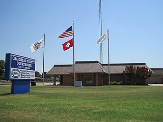
Craighead County is a county located in the U.S. state of Arkansas. As of the 2020 census, the population was 111,231. The county has two county seats — Jonesboro and Lake City. Craighead County is Arkansas's 58th county, formed on February 19, 1859, and named for state Senator Thomas Craighead. It is one of several dry counties within the state of Arkansas, in which the sale of alcoholic beverages is largely prohibited.

<span class="mw-page-title-main">Nimmons, Arkansas</span> Town in Arkansas, United States

Nimmons is a town in Clay County, Arkansas, United States. The population was 69 at the 2010 census, down from 100 in 2000.

<span class="mw-page-title-main">Bay, Arkansas</span> City in Arkansas, United States

Bay is a city in Craighead County, Arkansas, United States. The population was 1,876 at the 2020 census. It is included in the Jonesboro Metropolitan Statistical Area.

<span class="mw-page-title-main">Bono, Arkansas</span> Bono in Arkansas, United States

Bono is a city in Craighead County, Arkansas, United States. The population was 2,131 at the 2010 census, up from 1,512 in 2000. It is included in the Jonesboro, Arkansas Metropolitan Statistical Area. Bono's most prominent landmarks are the Bono Bridge and the Bono Cemetery.

<span class="mw-page-title-main">Brookland, Arkansas</span> City in Arkansas, United States

Brookland is a city in Craighead County, Arkansas, United States. The population was 1,642 at the 2010 census. It is included in the Jonesboro, Arkansas Metropolitan Statistical Area.

<span class="mw-page-title-main">Caraway, Arkansas</span> City in Arkansas, United States

Caraway is a city in Craighead County, Arkansas, United States. The population was 1,279 at the 2010 census. It is included in the Jonesboro, Arkansas Metropolitan Statistical Area.

<span class="mw-page-title-main">Egypt, Arkansas</span> Town in Arkansas, United States

Egypt is a town in Craighead County, Arkansas, United States. The population was 112 at the 2010 census. It is included in the Jonesboro, Arkansas Metropolitan Statistical Area.

<span class="mw-page-title-main">Jonesboro, Arkansas</span> City in Northeast Arkansas

Jonesboro is a city located on Crowley's Ridge in the northeastern corner of the U.S. State of Arkansas. Jonesboro is one of two county seats of Craighead County. In 2022, the city had an estimated population of 79,876, making it the fifth-most populous city in Arkansas. In 2020, the Jonesboro metropolitan area had a population of 134,196, and the Jonesboro-Paragould Combined Statistical Area had a population of 179,932.

<span class="mw-page-title-main">Lake City, Arkansas</span> City in Arkansas, United States

Lake City is a city in Craighead County, Arkansas, United States, along the St. Francis River. Lake City is one of two county seats in Craighead County. The population was 2,326 as of the 2020 census. It is included in the Jonesboro, Arkansas Metropolitan Statistical Area.

<span class="mw-page-title-main">Monette, Arkansas</span> City in Arkansas, United States

Monette is a city in Craighead County, Arkansas, United States. The city is located in an area of Northeast Arkansas known as Buffalo Island. The population was 1,506 at the 2020 census.

<span class="mw-page-title-main">Crawfordsville, Arkansas</span> Town in Arkansas, United States

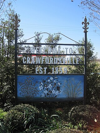
Crawfordsville, historically Crawfordville, is a town in Crittenden County, Arkansas, United States. The population was 479 at the 2010 census.

<span class="mw-page-title-main">Gilmore, Arkansas</span> City in Arkansas, United States

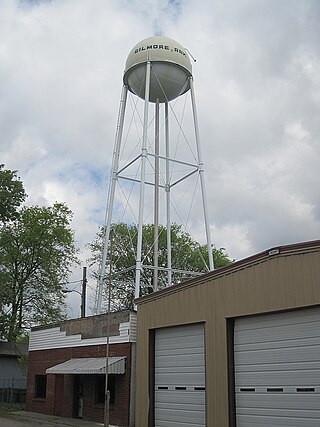
Gilmore is a city in Crittenden County, Arkansas, United States. Per the 2020 census, the population was 176.

<span class="mw-page-title-main">Paragould, Arkansas</span> City in Arkansas, United States

Paragould is the county seat of Greene County, and the 19th-largest city in Arkansas, in the United States. The city is located in northeastern Arkansas on the eastern edge of Crowley's Ridge, a geologic anomaly contained within the Arkansas delta.

<span class="mw-page-title-main">St. Paul, Arkansas</span> Town in Arkansas, United States

St. Paul is a town in Madison County, Arkansas, United States. The population was 111 at the 2020 census. It is on the edge of the Northwest Arkansas region.

<span class="mw-page-title-main">Leachville, Arkansas</span> City in Arkansas, United States

Leachville is a city in Mississippi County, Arkansas, United States. The population was 2,039 at the 2020 census. Leachville was incorporated in 1916.

<span class="mw-page-title-main">Manila, Arkansas</span> City in Arkansas, United States

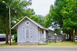
Manila is a city in Mississippi County, Arkansas, United States. The population was 3,682 at the 2020 census, up from 3,342 in 2010. It was the hometown of World War I sniper Herman Davis.

<span class="mw-page-title-main">Trumann, Arkansas</span> City in Arkansas, United States

Trumann is a city in Poinsett County, Arkansas, United States. The population was 7,399 at the 2020 census. It is included in the Jonesboro Metropolitan Statistical Area.

References

  1. "2020 U.S. Gazetteer Files". United States Census Bureau. Retrieved October 29, 2021.
  2. 1 2 U.S. Geological Survey Geographic Names Information System: Black Oak, Arkansas
  3. "Geographic Identifiers: 2010 Demographic Profile Data (G001): Black Oak town, Arkansas". U.S. Census Bureau, American Factfinder. Archived from the original on February 12, 2020. Retrieved June 18, 2014.
  4. PD-icon.svg This article incorporates public domain material from Woods, A.J., Foti, T.L., Chapman, S.S., Omernik, J.M.; et al. Ecoregions of Arkansas (PDF). United States Geological Survey.{{citation}}: CS1 maint: multiple names: authors list (link) (color poster with map, descriptive text, summary tables, and photographs).
  5. "Census of Population and Housing". Census.gov. Retrieved June 4, 2015.
  6. "Annual Estimates of the Resident Population for Incorporated Places: April 1, 2010 to July 1, 2014". Archived from the original on May 22, 2015. Retrieved June 4, 2015.
  7. "U.S. Census website". United States Census Bureau . Retrieved January 31, 2008.