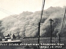
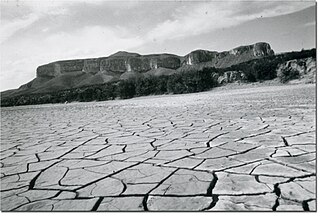
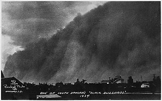
The Dust Bowl was the result of a period of severe dust storms that greatly damaged the ecology and agriculture of the American and Canadian prairies during the 1930s. The phenomenon was caused by a combination of natural factors and human-made factors: a failure to apply dryland farming methods to prevent wind erosion, most notably the destruction of the natural topsoil by settlers in the region. The drought came in three waves: 1934, 1936, and 1939–1940, but some regions of the High Plains experienced drought conditions for as long as eight years.

A dust storm, also called a sandstorm, is a meteorological phenomenon common in arid and semi-arid regions. Dust storms arise when a gust front or other strong wind blows loose sand and dirt from a dry surface. Fine particles are transported by saltation and suspension, a process that moves soil from one place and deposits it in another.

Texas County is a county located in the panhandle of the U.S. state of Oklahoma. Its county seat is Guymon. As of the 2020 census, the population was 21,384. It is the second largest county in Oklahoma, based on land area, and is named for Texas, the state that adjoins the county to its south. Texas County comprises the Guymon, OK Micropolitan Statistical Area. The county economy is largely based on farming and cattle production. It is one of the top-producing counties in the U.S. for wheat, cattle, and hogs. It also lies within the noted Hugoton-Panhandle natural gas field.

Cimarron County is the westernmost county in the U.S. state of Oklahoma. Its county seat is Boise City. As of the 2020 census, its population was 2,296, making it the least-populous county in Oklahoma; and indeed, throughout most of its history, it has had both the smallest population and the lowest population density of any county in Oklahoma. Located in the Oklahoma Panhandle, Cimarron County contains the only community in the state (Kenton) that observes the Mountain Time Zone. Black Mesa, the highest point in the state, is in the northwest corner of the county. The Cimarron County community of Regnier has the distinction of being the driest spot in Oklahoma ranked by lowest annual average precipitation, at just 15.62 inches; at the same time, Boise City is the snowiest location in Oklahoma ranked by highest annual average snowfall, at 31.6 inches.
Guymon is a city and county seat of Texas County, in the panhandle of Oklahoma, United States. As of the 2020 census, the city population was 12,965, an increase of 13.3% from 11,442 in 2010, and represents more than half of the population of the county, along with being the largest city in the Oklahoma Panhandle. Cattle feedlots, corporate pork farms, and natural gas production dominate its economy, with wind energy production and transmission recently diversifying landowners' farms. Guymon was the only town or city in Oklahoma in 2010 and 2020 in which the majority of the population was Hispanic.

Dryland farming and dry farming encompass specific agricultural techniques for the non-irrigated cultivation of crops. Dryland farming is associated with drylands, areas characterized by a cool wet season followed by a warm dry season. They are also associated with arid conditions, areas prone to drought and those having scarce water resources.
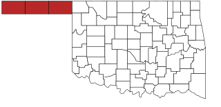
The Oklahoma Panhandle is a salient in the extreme northwestern region of the U.S. state of Oklahoma, consisting of Cimarron County, Texas County and Beaver County, from west to east. As with other salients in the United States, its name comes from the similarity of its shape to the handle of a pan. Its largest city is Guymon in Texas County. Black Mesa State Park, located in Cimarron County, is the highest point in the state. Other points of interest include Beaver Dunes Park, Optima Lake, and the Optima National Wildlife Refuge. Oklahoma Panhandle State University is ten miles away from Guymon.
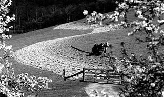
Contour bunding or contour farming or contour ploughing is the farming practice of plowing and/or planting across a slope following its elevation contour lines. These contour lines create a water break which reduces the formation of rills and gullies during times of heavy precipitation, allowing more time for the water to settle into the soil. In contour plowing, the ruts made by the plow run perpendicular rather than parallel to the slopes, generally furrows that curve around the land and are level. This method is also known for preventing tillage erosion. Tillage erosion is the soil movement and erosion by tilling a given plot of land. A similar practice is contour bunding where stones are placed around the contours of slopes. Contour ploughing has been proved to reduce fertilizer loss, power and time consumption, and wear on machines, as well as to increase crop yields and reduces soil erosion.

The Great Sioux Reservation initially set aside land west of the Missouri River in South Dakota and Nebraska for the use of the Sioux, who had dominated this territory. The reservation was established in the Fort Laramie Treaty of 1868. It included all of present-day western South Dakota and modern Boyd County, Nebraska. This area was established by the United States as a reservation for the Teton Sioux, also known as the Lakota: the seven western bands of the "Seven Council Fires".
Rita Blanca National Grassland is a National Grassland on the Great Plains near the community of Texline in northwest Dallam County, Texas, in the Texas Panhandle, and in southern Cimarron County, Oklahoma, in the western Oklahoma Panhandle. The principal city in the area is Dalhart, Texas, which houses the XIT Museum.
The 1983 Melbourne dust storm was a meteorological phenomenon that occurred during the afternoon of 8 February 1983, throughout much of Victoria, Australia and affected the capital, Melbourne. Red soil, dust and sand from Central and Southeastern Australia was swept up in high winds and carried southeast through Victoria. The dust storm was one of the most dramatic consequences of the 1982/83 drought, at the time the worst in Australian history and is, in hindsight, viewed as a precursor to the Ash Wednesday bushfires which were to occur eight days later.

The United States' contiguous western and especially southwestern region has experienced widespread drought since about year 2000. Below normal precipitation leads to drought, and is caused by an above average persistence of high pressure over the affected area. Changes in the track of extratropical cyclones, which can occur during climate cycles such as the El Niño-Southern Oscillation, or ENSO, as well as the North Atlantic Oscillation, Pacific Decadal Oscillation, and Atlantic multidecadal oscillation, modulate which areas are more prone to drought. Increased drought frequency and severity is also expected to be one of the effects of global warming.
The Last Man Club was a mutual support group for farmers that chose to stay in the Southern Plains of Texas, US in spite of the devastation caused by the Dust Bowl disaster of the 1930s. It was the first American Dream.
Henry Howard Finnell was an agronomist and erosion specialist who pioneered methods to combat soil erosion during the Dust Bowl that afflicted North America in the 1930s.

The Woody Guthrie Center is a public museum and archive located in Tulsa, Oklahoma that is dedicated to the life and legacy of American folk musician and singer-songwriter Woody Guthrie. The Center also contains the archives of folk singer, songwriter, and fellow social activist Phil Ochs.

The Central Great Plains are a semiarid prairie ecoregion of the central United States, part of North American Great Plains. The region runs from west-central Texas through west-central Oklahoma, central Kansas, and south-central Nebraska.
Caroline Henderson (1877–1966) was an American school teacher, farmer and author during the Dust Bowl. Born Caroline Boa in Wisconsin and raised in Iowa, she attended Mount Holyoke College, graduating in 1901. After teaching in Iowa until 1907, she relocated to Texas County in the Oklahoma Panhandle. She married local farmer, Bill Henderson, in 1908, the same year when she bought a 160-acre farm near Eva, Oklahoma. Caroline and Bill had one daughter, Eleanor, born in 1909.
The 1950s Texas drought was a period between 1949 and 1957 in which the state received 30 to 50% less rain than normal, while temperatures rose above average. During this time, Texans experienced the second-, third-, and eighth-driest single years ever in the state – 1956, 1954, and 1951, respectively. The drought was described by a state water official as "the most costly and one of the most devastating droughts in 600 years."

The 2016–17 North American winter was quite warm across North America in general, due in part to a weak La Niña that was expected to influence weather conditions across the continent. Several notable events occurred during the season, including a potent winter storm that affected the East Coast of the United States in early January, the second-largest winter tornado outbreak on record later that month, and an unusually warm February. In addition, towards the end of the season, a large cyclonic storm system that caused a large tornado outbreak, flooding, and a potent blizzard occurred in the Heartland of the country. However, the most notable event of the winter was a powerful blizzard that impacted the Northeast and New England in mid-March, towards the end of the season.
Excessive heat and drought problems affected the United States in 1934–35 from the Rocky Mountains, Texas and Oklahoma to parts of the Midwestern, Great Lakes, and Mid-Atlantic states. These droughts and excessive heat spells were parts of the Dust Bowl and concurrent with the Great Depression in the United States.