
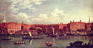
Blackfriars Bridge is a road and foot traffic bridge over the River Thames in London, between Waterloo Bridge and Blackfriars Railway Bridge, carrying the A201 road. The north end is near the Inns of Court and Temple Church, along with Blackfriars station. The south end is near the Tate Modern art gallery and the Oxo Tower.

Bermondsey is a district in South East London in the London Borough of Southwark, England, 2.5 miles (4.0 km) southeast of Charing Cross. To the west of Bermondsey lies Southwark, to the east Rotherhithe and Deptford, to the south Walworth and Peckham, and to the north is Wapping. It lies within the historic county boundaries of Surrey.

The London Borough of Southwark in south London forms part of Inner London and is connected by bridges across the River Thames to the City of London. It was created in 1965 when three smaller council areas amalgamated under the London Government Act 1963. All districts of the area are within the London postal district. It is governed by Southwark London Borough Council.
The River Fleet is the largest of London's subterranean rivers. Its headwaters are two streams on Hampstead Heath, each of which was dammed into a series of ponds—the Hampstead Ponds and the Highgate Ponds—in the 18th century. At the southern edge of Hampstead Heath these descend underground as sewers and join in Camden Town. The waters flow 4 mi (6 km) from the ponds to the River Thames.

The Elephant and Castle is an area around a major road junction in southeast London, England, in the London Borough of Southwark. Although the name also informally refers to the areas of Walworth and Newington, the proximity of the London Underground station of the same name has led to the area being more commonly known as "Elephant and Castle". The name is derived from a local coaching inn.

Southwark is a London Underground station in the London Borough of Southwark at the corner of Blackfriars Road and The Cut. It is between Waterloo and London Bridge stations on the Jubilee line, and is in Travelcard Zone 1. It was opened on 20 November 1999 as part of the Jubilee Line Extension. The station is somewhat west of historic Southwark, which is served by Borough and London Bridge stations. Its entrance is across the road from the disused Blackfriars Road railway station.

Blackfriars, also known as London Blackfriars, is a central London railway station and connected London Underground station in the City of London. It provides Thameslink services: local, and regional and limited Southeastern commuter services to South East London and Kent. Its platforms span the River Thames, the only one in London to do so, along the length of Blackfriars Railway Bridge, a short distance downstream from Blackfriars Bridge. There are two station entrances either side of the Thames, along with a connection to the London Underground District and Circle lines.

Borough High Street is a road in Southwark, London, running south-west from London Bridge, forming part of the A3 route which runs from London to Portsmouth, on the south coast of England.

Robert Mylne was a Scottish architect and civil engineer, particularly remembered for his design for Blackfriars Bridge in London. Born and raised in Edinburgh, he travelled to Europe as a young man, studying architecture in Rome under Piranesi. In 1758 he became the first Briton to win the triennial architecture competition at the Accademia di San Luca, which made his name known in London, and won him the rivalry of fellow Scot Robert Adam.

Borough Road is in Southwark, London SE1. It runs east-west between St George's Circus and Borough High Street.
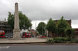
St George's Circus is a road junction in Southwark, London, England. At its centre, which is now a traffic roundabout, is an historic obelisk, designed by Robert Mylne (1733–1811), in his role as surveyor and architect of Blackfriars Bridge.

London Road is a road in Southwark, Central London, England, which connects St George's Circus (northwest) and the Elephant and Castle roundabout (southeast). To the east is the campus of London South Bank University including the Technopark building and the London Road Building, in a triangle formed by London Road, Borough Road and Newington Causeway. At the southeastern end is the Elephant and Castle tube station.

Westminster Bridge Road is a road in London, England. It runs on an east–west axis and passes through the boroughs of Lambeth and Southwark.

Waterloo Road is the main road in the Waterloo district of London, England straddling the boroughs of Lambeth and Southwark. It runs between Westminster Bridge Road close to St George's Circus at the south-east end and Waterloo Bridge across the River Thames towards London's West End district at the north-west end.

Southwark Bridge Road is a road in Southwark, London, England, between Newington Causeway near Elephant and Castle and Southwark Bridge across the River Thames, leading to the City of London, in a meandering route.
Southwark Street is a major street in Bankside in the London Borough of Southwark, in London England, just south of the River Thames. It runs between Blackfriars Road to the west and Borough High Street to the east. It also connects the access routes for London Bridge, Southwark Bridge and Blackfriars Bridge. At the eastern end to the north is Borough Market.

Union Street is a major street in the London Borough of Southwark. It runs between Blackfriars Road to the west and Borough High Street to the east. Southwark Bridge Road crosses in the middle.

London Buses route 63 is a Transport for London contracted bus route in London, England. Running between Honor Oak and King's Cross, it is operated by London Central.

The A201 is an A road in London running from Kings Cross to Bricklayer's Arms.
The Surrey Chapel (1783-1881) was an independent Methodist and Congregational church established in Blackfriars Road, Southwark, London on 8 June 1783 by the Rev. Rowland Hill. His work was continued in 1833 by the Congregational pastor Rev. James Sherman, and in 1854 by Rev. Newman Hall. The chapel's design attracted great interest, being circular in plan with a domed roof. When built it was set in open fields, but within a few years it became a new industrial area with a vast population characterised by great poverty amidst pockets of wealth. Recently the site itself has been redeveloped as an office block, and Southwark Underground Station has been built opposite.
