
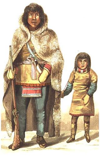
The Chipewyan are a Dene Indigenous Canadian people of the Athabaskan language family, whose ancestors are identified with the Taltheilei Shale archaeological tradition. They are part of the Northern Athabascan group of peoples, and come from what is now Western Canada.

Events from the year 1771 in Canada.
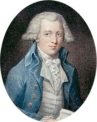
Samuel Hearne was an English explorer, fur-trader, author, and naturalist. He was the first European to make an overland excursion across northern Canada to the Arctic Ocean, specifically to Coronation Gulf, via the Coppermine River. In 1774, Hearne built Cumberland House for the Hudson's Bay Company, its second interior trading post after Henley House and the first permanent settlement in present Saskatchewan.

The Dene people are an indigenous group of First Nations who inhabit the northern boreal and Arctic regions of Canada. The Dene speak Northern Athabaskan languages. Dene is the common Athabaskan word for "people". The term "Dene" has two usages. More commonly, it is used narrowly to refer to the Athabaskan speakers of the Northwest Territories and Nunavut in Canada, especially including the Chipewyan (Denesuline), Tlicho (Dogrib), Yellowknives (T'atsaot'ine), Slavey, and Sahtu. However, it is sometimes also used to refer to all Northern Athabaskan speakers, who are spread in a wide range all across Alaska and northern Canada. The Southern Athabaskan speakers, however, also refer to themselves by similar words: Diné (Navajo) and Indé (Apache).

The Coppermine River is a river in the North Slave and Kitikmeot regions of the Northwest Territories and Nunavut in Canada. It is 845 kilometres (525 mi) long. It rises in Lac de Gras, a small lake near Great Slave Lake, and flows generally north to Coronation Gulf, an arm of the Arctic Ocean. The river freezes in winter but may still flow under the ice.

Kugluktuk, formerly known as Coppermine until 1 January 1996, is a hamlet located at the mouth of the Coppermine River in the Kitikmeot Region of Nunavut, Canada, on Coronation Gulf, southwest of Victoria Island. It is the westernmost community in Nunavut, near the border with the Northwest Territories.
Matonabbee was a Chipewyan hunter and leader. He was also a trader and a Chipewyan representative at the Prince of Wales Fort. He travelled with Chief Akaitcho's older brother, Keskarrah. After his father died, Matonabbee spent some time living at Prince of Wales Fort where he learned to speak English.
The Yellowknives, Yellow Knives, Copper Indians, Red Knives or T'atsaot'ine are indigenous peoples of Canada, one of the five main groups of the First Nations Dene who live in the Northwest Territories. The name, which is also the source for the later community of Yellowknife, derives from the colour of the tools made from copper deposits.
The Kazan River, is a Canadian Heritage River located in Nunavut, Canada. The Dene name for the river was Kasba-tue meaning "white partridge river." The name was apparently changed to Kazan in the late 19th century due to the influence of Order of Mary Immaculate missionaries. The river headwaters are in northern Saskatchewan at Kasba Lake, and it flows north for about 1,000 kilometres (620 mi) before emptying into Baker Lake, on the opposite side of the mouth of the Thelon River. Along its course the river flows through several lakes, including Ennadai Lake and Yathkyed Lake, over the Kazan Falls, down a red sandstone gorge and through both boreal forest and tundra. It is the last section of the river, below Ennadai Lake, that is above the timber line and is designated a Canadian Heritage River.
The history of the Northwest Territories covers the period from thousands of years ago to the present day. Prior to European colonization, the lands that encompass present-day Northwest Territories were inhabited for millennia by several First Nations. European explorers and fur traders began to explore the region since the late-16th century. By the 17th century, the British laid claim to both the North-Western Territory and Rupert's Land; and granted the Hudson's Bay Company a commercial fur trade monopoly over the latter region.
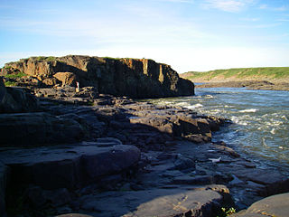
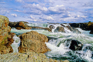
Bloody Falls is a waterfall on the Coppermine River, in the Kugluk/Bloody Falls Territorial Park of Nunavut, Canada. It was the site of the Bloody Falls Massacre in 1771 and the murder of two priests by Copper Inuit Uloqsaq and Sinnisiak in 1913.

Kugluk/Bloody Falls Territorial Park is located about 15 km (9.3 mi) southwest of Kugluktuk, Nunavut, Canada. The 10 ha park is situated around the Bloody Falls on the Coppermine River and was listed as a national historic site in 1978.

Copper Inuit, also known as Inuinnait and Kitlinermiut, are a Canadian Inuit group who live north of the tree line, in what is now the Kitikmeot Region of Nunavut and in the Inuvialuit Settlement Region in the Inuvik Region of the Northwest Territories. Most of them historically lived in the area around Coronation Gulf, on Victoria Island, and southern Banks Island.
Kogluktogmiut were a geographically defined Copper Inuit subgroup in the Canadian territory of Nunavut. They were located by Bloody Falls, a waterfall on the lower course of the Coppermine River in the Kugluk/Bloody Falls Territorial Park, notable for the Bloody Falls Massacre.

The Coppermine expedition of 1819–1822 was a British overland undertaking to survey and chart the area from Hudson Bay to the north coast of Canada, eastwards from the mouth of the Coppermine River. The expedition was organised by the Royal Navy as part of its attempt to discover and map the Northwest Passage. It was the first of three Arctic expeditions to be led by John Franklin and also included George Back and John Richardson, both of whom would become notable Arctic explorers in their own right.
Akaitcho was a Copper Indian, and Chief of the Yellowknives. His territory included the region from the eastern portion of the Great Slave Lake, in the Northwest Territories, Canada, to the Coppermine River, in Nunavut. He was recruited to act as interpreter, guide, and hunter for John Franklin's first of three Arctic expeditions, the Coppermine Expedition of 1819–1822.
The Rae–Richardson Arctic expedition of 1848 was an early British effort to determine the fate of the lost Franklin Polar Expedition. Led overland by Sir John Richardson and John Rae, the party explored the accessible areas along Franklin's proposed route near the Mackenzie and Coppermine rivers. No contact with Franklin's party was achieved and Rae later interviewed the Inuit of the region, from whom he obtained credible accounts that the desperate remnants of Franklin's party had resorted to cannibalism. This revelation was so unpopular that Rae was shunned by the Admiralty and popular opinion; the search for Franklin continued for several years.

Uloqsaq (also Uluksuk, and Uluksuk, alias Avingak was a Copper Inuit hunter of the Coppermine River region.
The Mackenzie River expedition of 1825–1827 was the second of three Arctic expeditions led by explorer John Franklin and organized by the Royal Navy. Its goal was the exploration of the North American coast between the mouths of the Mackenzie and Coppermine rivers and Bering Strait, in what is now present-day Alaska, Yukon, the Northwest Territories, and Nunavut. Franklin was accompanied by George Back and John Richardson, both of whom he had previously collaborated with in the disastrous Coppermine expedition of 1819–1821. Unlike Franklin's previous expedition, this one was largely successful, and resulted in the mapping of more than 1,000 km (620 mi) of new coastline between the Coppermine River and Prudhoe Bay, Alaska, an area that until then had remained largely unexplored by Europeans.
Moses Norton was a Hudson's Bay Company administrator who was chief factor of Fort Prince of Wales from 1762 until his death in 1773. A controversial figure throughout his life, he notably commissioned explorer Samuel Hearne's three expeditions in 1769–1772, which led to the first European discovery of the Coppermine River and the northern coast of Canada.

