Blue Mountains (New Zealand)

Last updated

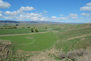
The Blue Mountains are a range of rugged hills in West Otago, in southern New Zealand. They form a barrier between the valleys of the Clutha and Pomahaka Rivers. They lie between the towns of Tapanui and Lawrence and rise to 1019 metres (3280 ft). [1]

West Otago is the local name given to part of the region of Otago, New Zealand, lying close to the border with Southland. It is administratively connected to South Otago, but is geographically separated from it by a range of hills known as the Blue Mountains. The largest settlements in West Otago are Tapanui and Heriot, and other localities within the area include Moa Flat, Edievale, Merino Downs, and Waikoikoi. The area described as West Otago is sometimes extended to include Lawrence and Beaumont. The ghost town of Kelso also lies within West Otago. Other notable features of the area include Conical Hill and Landslip Hill, the latter being a major fossil-bearing formation.

Clutha River river in New Zealand

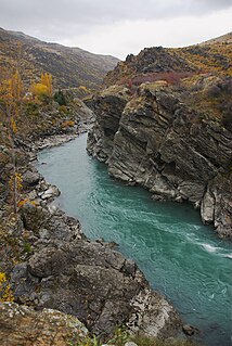
The Clutha River / Mata-Au is the second longest river in New Zealand and the longest in the South Island. It flows south-southeast 338 kilometres (210 mi) through Central and South Otago from Lake Wanaka in the Southern Alps to the Pacific Ocean, 75 kilometres (47 mi) south west of Dunedin. It is the highest volume river in New Zealand, and the swiftest, with a catchment of 21,960 square kilometres (8,480 sq mi), discharging a mean flow of 614 cubic metres per second (21,700 cu ft/s). The Clutha River is known for its scenery, gold-rush history, and swift turquoise waters. A river conservation group, the Clutha Mata-Au River Parkway Group, is working to establish a regional river parkway, with a trail, along the entire river corridor. The name of the river was changed to a dual name by the Ngai Tahu Claims Settlement Act 1998.

The Pomahaka River is in South Otago in New Zealand's South Island. It is a tributary of the Clutha River, flowing south for 80 kilometres (50 mi) from the Old Man Range of mountains to join the Clutha just north of Balclutha. Along its path it passes the Blue Mountains and the forestry town of Tapanui in the area known locally as West Otago.

The Blue Mountains are home to one of the largest herds of wild fallow deer in the south island of New Zealand, hunting is permitted on Department of Conservation administered land. The early name for the range was Te Papanui, which was later corrupted to Tapanui. Early surveyors named it Mount Valpy after William Henry Valpy, an early settler in Dunedin. The name Blue Mountains was given by gold diggers during the Otago Gold Rush in the early 1860s after the Blue Mountains in New South Wales. [2]

William Henry Valpy New Zealand settler

William Henry Valpy was a noted early settler of Dunedin, New Zealand. He is sometimes referred to locally as "The father of Saint Clair", as he was the first settler in the area now occupied by the suburb of Saint Clair.

Dunedin City in Otago, New Zealand

Dunedin is the second-largest city in the South Island of New Zealand, and the principal city of the Otago region. Its name comes from Dùn Èideann, the Scottish Gaelic name for Edinburgh, the capital of Scotland.

Otago Gold Rush

The Otago Gold Rush was a gold rush that occurred during the 1860s in Central Otago, New Zealand. This was the country's biggest gold strike, and led to a rapid influx of foreign miners to the area - many of them veterans of other hunts for the precious metal in California and Victoria, Australia.

Related Research Articles

Tapanui Town in Otago, New Zealand

Tapanui is a small town in West Otago in New Zealand's South Island, close to the boundary with Southland region. A forestry town, it lies between the foot of the Blue Mountains and the Pomahaka River. Deer stalking and trout fishing are popular pastimes of the area. For almost a hundred years, the town was serviced by the Tapanui Branch railway line, which despite its name never actually terminated in Tapanui. This line was formally opened in late 1880 and closed after being damaged by severe flooding in the region in October 1978. State Highway 90, which links State Highway 1 at McNab, near Gore, to State Highway 8 at Raes Junction, passes through Tapanui. The town is home to Blue Mountain College, which takes students up to year 13.

Manuherikia River river in New Zealand

The Manuherikia River is located in Otago in the South Island of New Zealand. It rises in the far north of the Maniototo, with the West Branch draining the eastern side of the St Bathans Range, and the East Branch draining the western flanks of the Hawkdun Range. The river continues southwest through the wide Manuherikia Valley to its confluence with the Clutha River at Alexandra. During the 1860s the Manuherikia was one of the centres of the Central Otago Gold Rush.

Gabriels Gully human settlement in New Zealand

Gabriel's Gully is a locality in Otago, New Zealand, three kilometres from Lawrence township and close to the Tuapeka River.

Saint Bathans human settlement in New Zealand

The former gold and coal mining town of Saint Bathans, formerly named Dunstan Creek, lies deep in the heart of the Maniototo in New Zealand's Otago region. Mining has long ceased, and it is a tranquil holiday retreat. The preservation of many of its historic buildings makes it one of the region's more picturesque tourist venues. Saint Bathans is well known for its scenic man-made lake with beautiful looking clay cliffs that attract many tourists. It is currently a camping spot, and swimming is allowed in the lake.

Clutha District Territorial authority in Otago, New Zealand

Clutha District is a local government district of southern New Zealand, with its headquarters in the Otago town of Balclutha. The Clutha District has a land area of 6,362.86 km² and a 2006 census population of 16,839 usual residents. Clutha District occupies the majority of the geographical area known as South Otago.

Landslip Hill is located on the boundary of Southland and Otago, in the South Island of New Zealand, between Tapanui and Pukerau. It is a debris flow feature associated with the Manuherikia Group of fluvial quartz sandstones. Geologists have described the fossil-bearing rocks as forming part of a sequence of "siliclastic fluvial deltaic sands, conglomerates and silty clays".

Blue Spur is the name of two geographic areas in New Zealand.

Kelso, New Zealand human settlement

Kelso is an abandoned small settlement in Otago, New Zealand, located ten kilometres north of Tapanui on the Crookston Burn, close to its junction with the larger Pomahaka River. Its population during the 1960s and 1970s was close to 300, with most of its economy based on sheep farming. A small dairy factory was a focal point in the village's early years.

Heriot is a small settlement in West Otago, in the South Island of New Zealand. It is located 20 kilometres southwest of Raes Junction and 15 kilometres north of Tapanui.

Kawarau Gorge canyon in New Zealand

The Kawarau Gorge is a major river gorge, located in Central Otago, in the South Island of New Zealand. The Kawarau River flows through the gorge, which is located between the towns of Queenstown and Cromwell, and part of the route of State Highway 6 also follows the gorge.

<i>Sigaus homerensis</i> species of insect

Sigaus homerensis is a grasshopper endemic to the southern South Island of New Zealand. It is known only from three isolated populations in Fiordland.

State Highway 90 is a New Zealand State Highway connecting the town of Gore on State Highway 1 to the locality of Raes Junction on State Highway 8 via Tapanui, servicing the agricultural areas of eastern Southland and West Otago. It is mostly hilly and is just under 60 kilometres long.

Ida Valley human settlement in New Zealand

The Ida Valley lies east of the Manuherikia Valley in Central Otago, New Zealand. At an altitude of around 500 m (1,600 ft), the 40 km long flat and wide valley is a relatively dry region with cold winters and hot summers, much like the rest of Central Otago. The majority of agricultural production in the Ida Valley is lamb, including merino, and also stud cattle. The valley is named after the Ida Burn, which joins the Poolburn and breaks through the Raggedy Range via the Poolburn Gorge.

Poolburn is a small rural settlement in Central Otago, in the South Island of New Zealand. It is located in the Ida Valley nine kilometres to the southeast of Ophir. It has a Primary School, a former Hotel, a community Hall,sports ground, tennis courts and a (closed) church. It has nearby historic gold mine workings at the eastern foot of the Raggedy Range.

Edievale is a small settlement in West Otago, in New Zealand's South Island. It lies equidistant between Heriot, which lies to the west, and Raes Junction, which lies to the east, on SH 90.

Port Molyneux

Port Molyneux is a tiny settlement on the coast of South Otago, New Zealand, close to the northeasternmost point of The Catlins. Now home only to farmland, it was a thriving port in the early years of New Zealand's European settlement.

References

  1. New Zealand 1:50000 Topographic Map Series sheet CE13 – Tapanui
  2. "Lost Names of New Zealand". Auckland Star . 55 (164). 12 July 1924. p. 25. Retrieved 1 November 2015.

Coordinates: 45°56′S169°23′E / 45.93°S 169.38°E / -45.93; 169.38

Geographic coordinate system Coordinate system

A geographic coordinate system is a coordinate system that enables every location on Earth to be specified by a set of numbers, letters or symbols. The coordinates are often chosen such that one of the numbers represents a vertical position and two or three of the numbers represent a horizontal position; alternatively, a geographic position may be expressed in a combined three-dimensional Cartesian vector. A common choice of coordinates is latitude, longitude and elevation. To specify a location on a plane requires a map projection.