Sputnik 1 was the first artificial Earth satellite. It was launched into an elliptical low Earth orbit by the Soviet Union on 4 October 1957 as part of the Soviet space program. It sent a radio signal back to Earth for three weeks before its three silver-zinc batteries became depleted. Aerodynamic drag caused it to fall back into the atmosphere on 4 January 1958.

North Rhine-Westphalia or North-Rhine/Westphalia, commonly shortened to NRW, is a state (Land) in Western Germany. With more than 18 million inhabitants, it is the most populous state in Germany. Apart from the city-states, it is also the most densely populated state in Germany. Covering an area of 34,084 km2 (13,160 sq mi), it is the fourth-largest German state by size.

Venera 1, also known as Venera-1VA No.2 and occasionally in the West as Sputnik 8 was the first spacecraft to perform an interplanetary flight and the first to fly past Venus, as part of the Soviet Union's Venera programme. Launched in February 1961, it flew past Venus on 19 May of the same year; however, radio contact with the probe was lost before the flyby, resulting in it returning no data.

Dortmund is the third-largest city in North Rhine-Westphalia, after Cologne and Düsseldorf, and the ninth-largest city in Germany. With a population of 612,065 inhabitants, it is the largest city of the Ruhr as well as the largest city of Westphalia. It lies on the Emscher and Ruhr rivers in the Rhine-Ruhr Metropolitan Region, the second biggest metropolitan region by GDP in the European Union, and is considered the administrative, commercial, and cultural centre of the eastern Ruhr. Dortmund is the second-largest city in the Low German dialect area, after Hamburg.

Jodrell Bank Observatory in Cheshire, England hosts a number of radio telescopes as part of the Jodrell Bank Centre for Astrophysics at the University of Manchester. The observatory was established in 1945 by Bernard Lovell, a radio astronomer at the university, to investigate cosmic rays after his work on radar in the Second World War. It has since played an important role in the research of meteoroids, quasars, pulsars, masers, and gravitational lenses, and was heavily involved with the tracking of space probes at the start of the Space Age.

Bochum is a city in North Rhine-Westphalia. With a population of 372,348, it is the sixth-largest city in North Rhine-Westphalia, one of the most populous German federal states, and the 16th-largest city in Germany. On the Ruhr Heights hill chain, between the rivers Ruhr to the south and Emscher to the north, it is the second largest city of Westphalia after Dortmund, and the fourth largest city of the Ruhr after Dortmund, Essen and Duisburg. It lies at the centre of the Ruhr, Germany's largest urban area, in the Rhine-Ruhr Metropolitan Region, the second biggest metropolitan region by GDP in the European Union, and belongs to the region of Arnsberg. Bochum is the sixth largest and one of the southernmost cities in the Low German dialect area. There are nine institutions of higher education in the city, most notably the Ruhr University Bochum, one of the ten largest universities in Germany, and the Bochum University of Applied Sciences.
Radar astronomy is a technique of observing nearby astronomical objects by reflecting radio waves or microwaves off target objects and analyzing their reflections. Radar astronomy differs from radio astronomy in that the latter is a passive observation and the former an active one. Radar systems have been conducted for six decades applied to a wide range of Solar System studies. The radar transmission may either be pulsed or continuous. The strength of the radar return signal is proportional to the inverse fourth-power of the distance. Upgraded facilities, increased transceiver power, and improved apparatus have increased observational opportunities.

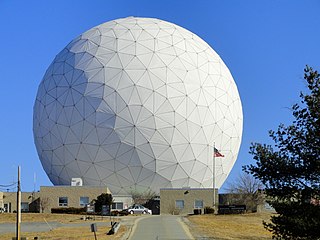
A radome is a structural, weatherproof enclosure that protects a radar antenna. The radome is constructed of material transparent to radio waves. Radomes protect the antenna from weather and conceal antenna electronic equipment from view. They also protect nearby personnel from being accidentally struck by quickly rotating antennas.
Haystack Observatory is a multidisciplinary radio science center, ionospheric observatory, and astronomical microwave observatory owned by Massachusetts Institute of Technology (MIT). It is in Westford, Massachusetts, in the United States, about 45 kilometers (28 mi) northwest of Boston. The observatory was built by MIT's Lincoln Laboratory for the United States Air Force and was called the Haystack Microwave Research Facility. Construction began in 1960, and the antenna began operating in 1964. In 1970 the facility was transferred to MIT, which then formed the Northeast Radio Observatory Corporation (NEROC) with other universities to operate the site as the Haystack Observatory. As of January 2012, a total of nine institutions participated in NEROC.

The Kunstsammlung Nordrhein-Westfalen is the art collection of the German Federal State of North Rhine-Westphalia, in Düsseldorf. United by this institution are three different exhibition venues: the K20 at Grabbeplatz, the K21 in the Ständehaus, and the Schmela Haus. The Kunstsammlung was founded in 1961 by the state government of North Rhine-Westphalia as a foundation under private law for the purpose of displaying the art collection and expanding it through new acquisitions.
Gordon Hemenway Pettengill was an American radio astronomer and planetary physicist. He was one of the first to take radar from its original military application to its use as a tool for astronomy. He was professor emeritus at the Massachusetts Institute of Technology.

The Algonquin Radio Observatory (ARO) is a radio observatory located in Algonquin Provincial Park in Ontario, Canada. It opened in 1959 in order to host a number of the National Research Council of Canada's (NRC) ongoing experiments in a more radio-quiet location than Ottawa.

The Medicina Radio Observatory is an astronomical observatory located 30 km from Bologna, Italy. It is operated by the Institute for Radio Astronomy of the National Institute for Astrophysics (INAF) of the government of Italy.

Third-party evidence for Apollo Moon landings is evidence, or analysis of evidence, about the Moon landings that does not come from either NASA or the U.S. government, or the Apollo Moon landing hoax theorists. This evidence provides independent confirmation of NASA's account of the six Apollo program Moon missions flown between 1969 and 1972.

The Mount Fuji Radar System is a historic weather radar system located on the summit of Mount Fuji, Japan. It was completed on August 15, 1964, and is now recorded on the list of IEEE Milestones in electrical engineering. When first built, the Mount Fuji Radar System was the world's highest weather radar, and could observe major weather phenomena, such as destructive typhoons, at a range of more than 800 kilometres (500 mi). It was designed by the Japan Meteorological Agency and built by Mitsubishi Electric Corporation.
The Prince Albert Radar Laboratory (PARL) was a radar research facility operated by the Defence Research Telecommunications Establishment (DRTE), part of the Canadian Defence Research Board. Its primary purpose was to test long-range radio propagation and radar techniques in the presence of the aurora borealis. This was part of a greater ABM effort being carried out in concert with the United States Air Force, and PARL operated along with two similar instruments at the Rome Air Development Centre and MIT Lincoln Laboratory. The site continues to operate today, used as a satellite downlink station known as the Prince Albert Satellite Station (PASS).

Heinz Kaminski was a German chemical engineer and space researcher.

Cerro Murphy Observatory is an international astrophysical project hosted by the ESO Paranal Observatory and operated by the Nicolaus Copernicus Astronomical Center of the Polish Academy of Sciences. The observatory is located on Cerro Murphy, which is a hill located 1 kilometre to the southwest and 230 metres (750 ft) below the summit of Cerro Armazones, a mountain in the Antofagasta Region of Chile, 120 km (75 mi) south of Antofagasta. OCM is located at 2,817 m (9,242 ft) altitude and currently houses 5 telescopes, whose diameters range between 0.3 and 1.5 m.
The Space Safety Programme, formerly the Space Situational Awareness (SSA) programme, is the European Space Agency's (ESA) initiative to monitor hazards from space, determine their risk, make this data available to the appropriate authorities and where possible, mitigate the threat.

Karl Ganser was a German geographer, urban planner, and former managing director of the International Architecture Exhibition Emscher Park.