British Columbia (BC) is the westernmost province of Canada, situated between the Pacific Ocean and the Rocky Mountains. With an estimated population of 5.1 million as of 2021, it is Canada's third-most populous province. The capital of British Columbia is Victoria, the fifteenth-largest metropolitan region in Canada, named for Queen Victoria, who reigned over the British Empire at the time of Confederation. The largest city is Vancouver, the third-largest metropolitan area in Canada, the largest in Western Canada, and the second-largest in the Pacific Northwest. In October 2013, Greater Vancouver had an estimated population of approximately 2.5 million. Since 2017, the province has been governed by the New Democratic Party, led by John Horgan, first with a minority government elected in 2017 and subsequently with a majority government elected in 2020.

The Fraser River is the longest river within British Columbia, Canada, rising at Fraser Pass near Blackrock Mountain in the Rocky Mountains and flowing for 1,375 kilometres (854 mi), into the Strait of Georgia just south of the City of Vancouver. It is the 11th longest river in Canada. The river's annual discharge at its mouth is 112 cubic kilometres (27 cu mi) or 3,550 cubic metres per second (125,000 cu ft/s), and it discharges 20 million tons of sediment into the ocean.

The Fraser Valley is a geographical region in southwestern British Columbia, Canada, and typically describes the Fraser River basin downstream of the Fraser Canyon. The term is sometimes used outside British Columbia to refer to the entire Fraser River sections including the Fraser Canyon and up from there to its headwaters, but in general British Columbian usage the term refers to the stretch of Lower Mainland west of the Coquihalla River mouth at the inland town of Hope, and includes all of the Canadian portion of the Fraser Lowland as well as the valleys and upland areas flanking it. It is divided into the Upper Fraser Valley and Lower Fraser Valley by the Vedder River mouth and the Sumas Mountain.

Lillooet, formerly Cayoosh Flat, is a community on the Fraser River in British Columbia, Canada, about 240 km (150 mi) up the British Columbia Railway line from Vancouver. Situated at an intersection of deep gorges in the lee of the Coast Mountains, it has a dry climate with an average of 329.5 mm (12.97 in) of precipitation being recorded annually. Lillooet has a long growing season, and once had prolific market gardens and orchard produce. It often vies with Lytton and Osoyoos for the title of "Canada's Hot Spot" on a daily basis in summer.

The Kettle Valley Railway was a subsidiary of the Canadian Pacific Railway (CPR) that operated across southern British Columbia, west of Midway running to Rock Creek, then north to Myra Canyon, down to Penticton over to Princeton, Coalmont, Brookmere, Coquihalla and finally Hope where it connected to the main CPR line.

Andrew Onderdonk was an American construction contractor who worked on several major projects in the West, including the San Francisco seawall in California and the Canadian Pacific Railway in British Columbia. He was born on August 30, 1848 in New York City, New York to an established ethnic Dutch family. He received his education at the Rensselaer Polytechnic Institute.

The Thompson River is the largest tributary of the Fraser River, flowing through the south-central portion of British Columbia, Canada. The Thompson River has two main branches, the South Thompson River and the North Thompson River. The river is home to several varieties of Pacific salmon and trout. The area's geological history was heavily influenced by glaciation, and the several large glacial lakes have filled the river valley over the last 12,000 years. Archaeological evidence shows human habitation in the watershed dating back at least 8,300 years. The Thompson was named by Fraser River explorer, Simon Fraser, in honour of his friend, Columbia Basin explorer David Thompson. Recreational use of the river includes whitewater rafting and angling.

Lytton is a village of about 250 residents in southern British Columbia, Canada on the east side of the Fraser River and primarily the south side of the Thompson River where it flows southwesterly into the Fraser. The community includes the Village of Lytton and the surrounding community of the Lytton First Nation, whose name for the place is Camchin, also spelled Kumsheen.
Yale is an unincorporated town in the Canadian province of British Columbia.

The Fraser Canyon is a major landform of the Fraser River where it descends rapidly through narrow rock gorges in the Coast Mountains en route from the Interior Plateau of British Columbia to the Fraser Valley. Colloquially, the term "Fraser Canyon" is often used to include the Thompson Canyon from Lytton to Ashcroft, since they form the same highway route which most people are familiar with, although it is actually reckoned to begin above Williams Lake, British Columbia at Soda Creek Canyon near the town of the same name.

The Clear Range is a small mountain range located in the angle of the Fraser and Thompson Rivers in south-central British Columbia. It has a small subdivision just northeast of that confluence named the Scarped Range. The Clear Range totals 16,270 km² (6,280 mi²) and is 75 km (47 mi) north to south and 35 km (22 mi) east to west. The Clear Range and its northward neighbour the Marble Range are both subranges of the Pavilion Range.

The British Columbia Interior, popularly referred to as the BC Interior or simply the Interior, is a geographic region of the Canadian province of British Columbia. While the exact boundaries are variously defined, the British Columbia Interior is generally defined to include the 14 regional districts that do not have coastline along the Pacific Ocean or Salish Sea, and are not part of the Lower Mainland. Other boundaries may exclude parts of or even entire regional districts, or expand the definition to include the regional districts of Fraser Valley, Squamish-Lillooet, and Kitimat-Stikine.

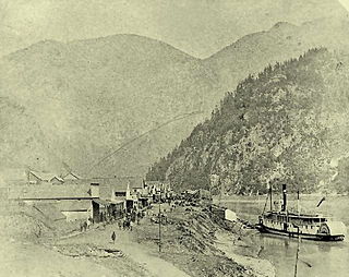
Skuzzy was a sternwheeler built by Canadian Pacific Railway contractor Andrew Onderdonk at Spuzzum, British Columbia, and was launched on the Fraser River on May 4, 1882. Skuzzy was the first sternwheeler to ever navigate the perilous rapids north of Yale in the Fraser Canyon.

Siska, also known historically as Cisco, is a locality in the Fraser Canyon of British Columbia, Canada 9.4 kilometres south of the town of Lytton. It is at Siska that the Canadian Pacific and Canadian National Railways switch from one side of the river to the other, due to the impossibility of both railways occupying the same bank of the Fraser due to the narrow and steep terrain. The resulting pair of bridges, with the CNR bridge just upstream of the CPR's, and the CPR's bridge's west foot entering the Cantilever Bar Tunnel into the side of Cisco Bluff, remains one of the most famous images of the CPR's route through British Columbia today and is easily viewable from the adjacent Trans-Canada Highway.

Thompson Country, also referred to as The Thompson and sometimes as the Thompson Valley and historically known as the Couteau Country or Couteau District, is a historic geographic region of the Southern Interior of British Columbia, more or less defined by the basin of the Thompson River. This is a tributary of the Fraser; the major city in the area is Kamloops.
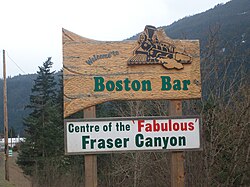
North Bend is an unincorporated community in the Fraser Canyon region of British Columbia, Canada, located across the Fraser River from the town of Boston Bar. North Bend was originally known as Boston Bar, but that name moved across the Fraser River when the site was renamed North Bend.
Boston Bar station is a railway station in Boston Bar, British Columbia, Canada, located at the border of CN's Ashcroft subdivision.
North Bend station is a railway station in North Bend, British Columbia, Canada, located at the border between CPR's Cascade- and Thompson subdivision.
The Cisco Bridges are a pair of railroad bridges at Siska near Lytton, British Columbia, Canada. The Canadian Pacific Railway and Canadian National Railway both follow the route of the Fraser River, one on each side, and the routes exchange sides at this point. The easier CPR route was laid first; when the CNR arrived later they needed to follow the more difficult route. The area is popular with railfans due to the proximity of the two bridges, and the easy access to the area is parallel to both bridges down the east bank of the river. Directional running in the Fraser Canyon means that both CPR and CNR trains may be seen on both bridges. Although this area is generally known as Cisco, the actual CN timetable station point of Cisco is approximately 2.5 miles to the east of the bridges.
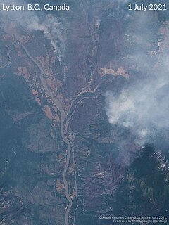
The Lytton Fire, also known as the Lytton Creek Fire, is an ongoing wildfire that started on June 30, 2021 just south of the village of Lytton in the interior of British Columbia, Canada. The fire destroyed much of Lytton and caused two civilian fatalities, announced July 3. Several missing residents, still unaccounted for at that time, were later located. The fire, one of the 2021 British Columbia wildfires throughout the province, was facilitated by the 2021 Western North America heat wave.