History
Early History
At its founding Bouna was a Koulango and Dyula village. In the late 16th century Bouna was conquered by the Dagomba prince Darigu Diembda, who married the local chief's daughter. Their son Bounkani founded the royal dynasty of Bouna. [3] : 71
Bouna was a "highly centralized kingdom based on military districts administered by princes" who exploited the local gold deposits. [4] Like Kong, it became a major center of Islamic learning. [5] [3] : 72 Bouna was a refuge for the imam of Bighu after the collapse of that city, [6] as well as the Muslim scholars driven out of the Ashanti court in the 1820s. [3] : 88
Samori Ture
By 1895 the Wassoulou Empire under Samori Ture had pushed east and conquered Kong, and was eyeing Bouna as a link to British-held Gold Coast, a source of firearms. His son Saranken Mori captured the town in December 1896, installing the local Cisse as Imams in place of the Kamara family who had plotted against them. [3] : 73
In April 1897, Governor William Edward Maxwell tried to intimidate Saranken Mori into abandoning Bouna to the British. When this failed, a force of the Southern Nigeria Regiment under Henderson marched on the town but were defeated at Dokita, then later routed and Henderson was captured at Wa. [7] : 117–8
Knowing this setback would prompt an aggressive British response, the French sent Capt. Paul Braulot [ fr ], at the head of an armed column, to try to acquire Bouna by negotiation. Saranken Mori initially accepted. [7] : 117–9 But when Braulot arrived, he was killed and his column destroyed outside the city on August 20, 1897, restarting the war between Wassoulou and the French. [8] Ture was defeated and captured the next year.
Post-Independence
Bouna was one of the main strongholds of the Forces Nouvelles de Côte d'Ivoire, the rebel army of the 2002 attempted coup d'état. The general population of Bouna suffered greatly in the early days of the rebellion.

Samory Toure, also known as Samori Toure, Samory Touré, or Almamy Samore Lafiya Toure, was a Mandinka Muslim cleric, military strategist, and founder of the Wassoulou Empire, an Islamic empire that was stretched across present-day north and eastern Guinea, north-eastern Sierra Leone, southern Mali, northern Côte d'Ivoire and part of southern Burkina Faso.

Kankan is the largest city in Guinea in land area, and the third largest in population, with a population of 198,013 people as of 2020. The city is located in eastern Guinea about 555 kilometres east of the national capital Conakry.
Wassoulou is a cultural area and historical region in the Wassoulou River Valley of West Africa. It is home to about 160,000 people, and is also the native land of the Wassoulou genre of music.

The Wassoulou empire, also referred to as the Mandinka Empire, Samory's Empire or the Samorian State, was a short-lived West African state that existed from roughly 1878 until 1898, although dates vary from source to source. It spanned from what is now southwestern Mali and upper Guinea, with its capital in Bissandugu; it expanded further south and east into northern Ghana and Ivory Coast before its downfall.

Bondoukou is a city in northeastern Ivory Coast, 420 km northeast of Abidjan. It is the seat of both Zanzan District and Gontougo Region. It is also a commune and the seat of and a sub-prefecture of Bondoukou Department.
The Mandingo Wars were a series of conflicts from 1883 to 1898 between France and the Wassoulou Empire of the Mandingo people led by Samori Ture. Comparatively, the French faced serious resistance by the Mandinka, as they were able to make use of firearms and tactics that impeded French expansion in the area. The French were ultimately triumphant and established dominance over Mali, Guinea and the Ivory Coast.

Kong, also known as Kpon, is a town in northern Ivory Coast. It is a sub-prefecture of and the seat of Kong Department in Tchologo Region, Savanes District. Kong is also a commune. It was the capital of the Kong Empire (1710–1895).
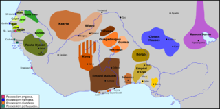
The Kong Empire (1710–1898), also known as the Wattara Empire or Ouattara Empire for its founder, was a pre-colonial African Muslim state centered in northeastern Ivory Coast that also encompassed much of present-day Burkina Faso. It was founded by Dyula immigrants from the declining Mali Empire. It established a largely decentralized commercial empire based upon linkages by merchant houses protecting trade routes throughout the region. Kong rose to prominence in the 1800s as a key commercial center and center of Islamic studies. In 1898, Samori Ture attacked the city and burnt it down. Although the city was rebuilt, the Kong empire had dissipated and the French took control over the area.
Ouangolodougou is a town in the far north of Ivory Coast, adjacent to the border with Burkina Faso. It is a sub-prefecture of and the seat of Ouangolodougou Department in Tchologo Region, Savanes District. Ouangolodougou is also a commune. In 2021, the population of the sub-prefecture of Ouangolodougou was 82,801.
Bouko is a town in north-eastern Ivory Coast. It is a sub-prefecture of Bouna Department in Bounkani Region, Zanzan District.
Doropo is a town in the far northeast of Ivory Coast. It is a sub-prefecture of and the seat of Doropo Department in Bounkani Region, Zanzan District, adjacent to the border with Burkina Faso. Doropo is also a commune. Fifteen kilometres northwest of town is a border crossing with Burkina Faso. In 2021, the population of the sub-prefecture of Doropo was 48,225.
Ondéfidouo is a town in northeastern Ivory Coast. It is a sub-prefecture of Bouna Department in Bounkani Region, Zanzan District.
Kiniéran is a town and sub-prefecture in the Mandiana Prefecture in the Kankan Region of eastern Guinea. As of 2014 it had a population of 37,944 people.
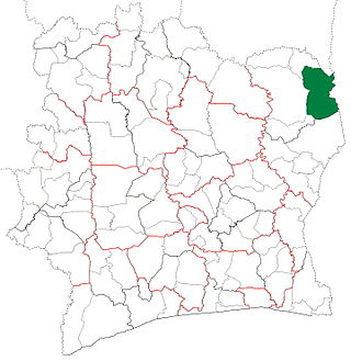
Bouna Department is a department of Bounkani Region in Zanzan District, Ivory Coast. In 2021, its population was 178,081 and its seat is the settlement of Bouna. The sub-prefectures of the department are Bouko, Bouna, Ondéfidouo, and Youndouo.

Nassian Department is a department of Bounkani Region in Zanzan District, Ivory Coast. In 2021, its population was 71,724 and its seat is the settlement of Nassian. The sub-prefectures of the department are Bogofa, Kakpin, Koutouba, Nassian, and Sominassé.
Kineta is a village in north-eastern Ivory Coast. It is in the sub-prefecture of Ondéfidouo, Bouna Department, Bounkani Region, Zanzan District. Kineta is near the border with Ghana.

Zanzan District is one of fourteen administrative districts of Ivory Coast. The district is located in the northeast of the country. The capital of the district is Bondoukou.

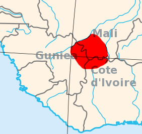
Bounkani Region is one of the 31 regions of Ivory Coast. Since its establishment in 2011, it has been one of two regions in Zanzan District. The seat of the region is Bouna and the region's population in the 2021 census was 427,037.

Doropo Department is a department of Bounkani Region in Zanzan District, Ivory Coast. In 2021, its population was 93,386 and its seat is the settlement of Doropo. The sub-prefectures of the department are Danoa, Doropo, Kalamon, and Niamoué.

Téhini Department is a department of Bounkani Region in Zanzan District, Ivory Coast. In 2021, its population was 83,846 and its seat is the settlement of Téhini. The sub-prefectures of the department are Gogo, Téhini, and Tougbo.


