AutoCAD DXF is a CAD data file format developed by Autodesk for enabling data interoperability between AutoCAD and other programs.
AutoLISP is a dialect of the programming language Lisp built specifically for use with the full version of AutoCAD and its derivatives, which include AutoCAD Map 3D, AutoCAD Architecture and AutoCAD Mechanical. Neither the application programming interface (API) nor the interpreter to execute AutoLISP code is included in the AutoCAD LT product line. A subset of AutoLISP functions is included in the browser-based AutoCAD web app.

Surveying or land surveying is the technique, profession, art, and science of determining the terrestrial two-dimensional or three-dimensional positions of points and the distances and angles between them. A land surveying professional is called a land surveyor. These points are usually on the surface of the Earth, and they are often used to establish maps and boundaries for ownership, locations, such as the designed positions of structural components for construction or the surface location of subsurface features, or other purposes required by government or civil law, such as property sales.

An engineering drawing is a type of technical drawing that is used to convey information about an object. A common use is to specify the geometry necessary for the construction of a component and is called a detail drawing. Usually, a number of drawings are necessary to completely specify even a simple component. These drawings are linked together by a "master drawing." This "master drawing" is more commonly known as an assembly drawing. The assembly drawing gives the drawing numbers of the subsequent detailed components, quantities required, construction materials and possibly 3D images that can be used to locate individual items. Although mostly consisting of pictographic representations, abbreviations and symbols are used for brevity and additional textual explanations may also be provided to convey the necessary information.

The Public Land Survey System (PLSS) is the surveying method developed and used in the United States to plat, or divide, real property for sale and settling. Also known as the Rectangular Survey System, it was created by the Land Ordinance of 1785 to survey land ceded to the United States by the Treaty of Paris in 1783, following the end of the American Revolution. Beginning with the Seven Ranges in present-day Ohio, the PLSS has been used as the primary survey method in the United States. Following the passage of the Northwest Ordinance in 1787, the Surveyor General of the Northwest Territory platted lands in the Northwest Territory. The Surveyor General was later merged with the General Land Office, which later became a part of the U.S. Bureau of Land Management (BLM). Today, the BLM controls the survey, sale, and settling of lands acquired by the United States.

The Virginia Military District was an approximately 4.2 million acre (17,000 km²) area of land in what is now the state of Ohio that was reserved by Virginia to use as payment in lieu of cash for its veterans of the American Revolutionary War.

In the United States, a plat (plan) is a cadastral map, drawn to scale, showing the divisions of a piece of land. United States General Land Office surveyors drafted township plats of Public Lands Surveys to show the distance and bearing between section corners, sometimes including topographic or vegetation information. City, town or village plats show subdivisions broken into blocks with streets and alleys. Further refinement often splits blocks into individual lots, usually for the purpose of selling the described lots; this has become known as subdivision.
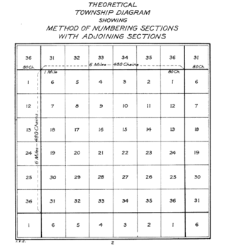
In U.S. land surveying under the Public Land Survey System (PLSS), a section is an area nominally one square mile, containing 640 acres, with 36 sections making up one survey township on a rectangular grid.
Metes and bounds is a system or method of describing land, real property or real estate. The system has been used in England for many centuries and is still used there in the definition of general boundaries. The system is also used in the Canadian province of Ontario, and throughout Canada for the description of electoral districts. By custom, it was applied in the original Thirteen Colonies that became the United States and in many other land jurisdictions based on English common law, including Zimbabwe, South Africa, India and Bangladesh. While still in hand-me-down use, this system has been largely overtaken in the past few centuries by newer systems such as rectangular and lot and block.

A cadastre or cadaster is a comprehensive recording of the real estate or real property's metes-and-bounds of a country. Often it is represented graphically in a cadastral map.
Land registration is any of various systems by which matters concerning ownership, possession, or other rights in land are formally recorded to provide evidence of title, facilitate transactions, and prevent unlawful disposal. The information recorded and the protection provided by land registration varies widely by jurisdiction.
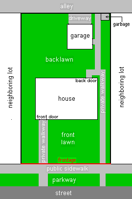
In real estate, a lot or plot is a tract or parcel of land owned or meant to be owned by some owner(s). A plot is essentially considered a parcel of real property in some countries or immovable property in other countries. Possible owners of a plot can be one or more persons or another legal entity, such as a company, corporation, organization, government, or trust. A common form of ownership of a plot is called fee simple in some countries.

A boundary marker, border marker, boundary stone, or border stone is a robust physical marker that identifies the start of a land boundary or the change in a boundary, especially a change in direction of a boundary. There are several other types of named border markers, known as boundary trees, pillars, monuments, obelisks, and corners. Border markers can also be markers through which a border line runs in a straight line to determine that border. They can also be the markers from which a border marker has been fixed.

IntelliCAD is a CAD editor and development platform with an Application Programming Interface API published by the IntelliCAD Technology Consortium ("ITC") through shared development. IntelliCAD emulates the basic interface and functions of AutoCAD, however, it is particularly able to incorporate and interchange freely between a wide variety of file types.
Construction surveying or building surveying is to provide dimensional control for all stages of construction work, including the stake out of reference points and markers that will guide the construction of new structures such as roads, rail, or buildings. These markers are usually staked out according to a suitable coordinate system selected for the project.
The Association of Canada Lands Surveyors (ACLS) is the national licensing body for professionals surveying in the three Canadian territories, in the Federal parks, on Aboriginal reserves, as well as on and under the surface of Canada's oceans. It is a self-governing, non-profit, non-governmental organization that manages the activities of its members across Canada in the field of cadastral surveying.
Land administration is the way in which the rules of land tenure are applied and made operational. Land administration, whether formal or informal, comprises an extensive range of systems and processes to administer. The processes of land administration include the transfer of rights in land from one party to another through sale, lease, loan, gift and inheritance; the regulating of land and property development; the use and conservation of the land; the gathering of revenues from the land through sales, leasing, and taxation; and the resolving of conflicts concerning the ownership and the use of land. Land administration functions may be divided into four components: Juridical, regulatory, fiscal, and information management. These functions of land administration may be organized in terms of agencies responsible for surveying and mapping, land registration, land valuation and land revenue generation. The purpose and scope of this knowledge domain appear from the following introducing notes:

A constraint in computer-aided design (CAD) software is a limitation or restriction imposed by a designer or an engineer upon geometric properties of an entity of a design model that maintains its structure as the model is manipulated. These properties can include relative length, angle, orientation, size, shift, and displacement. The plural form constraints refers to demarcations of geometrical characteristics between two or more entities or solid modeling bodies; these delimiters are definitive for properties of theoretical physical position and motion, or displacement in parametric design. The exact terminology, however, may vary depending on a CAD program vendor.
Cadastral surveying is the sub-field of cadastre and surveying that specialises in the establishment and re-establishment of real property boundaries. It involves the physical delineation of property boundaries and determination of dimensions, areas and certain rights associated with properties. This is regardless of whether they are on land, water or defined by natural or artificial features. It is an important component of the legal creation of properties. A cadastral surveyor must apply both the spatial-measurement principles of general surveying and legal principles such as respect of neighboring titles.

In English common law, real property, real estate, immovable property or, solely in the US and Canada, realty, refers to parcels of land and any associated structures which are the property of a person. In order for a structure to be considered part of the real property, it must be integrated with or affixed to the land. Examples include crops, buildings, machinery, wells, dams, ponds, mines, canals, and roads. The term is historic, arising from the now-discontinued form of action, which distinguished between real property disputes and personal property disputes. Personal property, or personalty, was, and continues to be, all property that is not real property.

