
Santa Barbara County, officially the County of Santa Barbara, is located in Southern California. As of the 2020 census, the population was 448,229. The county seat is Santa Barbara, and the largest city is Santa Maria.

Santa Ynez is a census-designated place (CDP) in the Santa Ynez Valley of Santa Barbara County, California.

The Central Valley Project (CVP) is a federal power and water management project in the U.S. state of California under the supervision of the United States Bureau of Reclamation (USBR). It was devised in 1933 in order to provide irrigation and municipal water to much of California's Central Valley—by regulating and storing water in reservoirs in the northern half of the state, and transporting it to the water-poor San Joaquin Valley and its surroundings by means of a series of canals, aqueducts and pump plants, some shared with the California State Water Project (SWP). Many CVP water users are represented by the Central Valley Project Water Association.
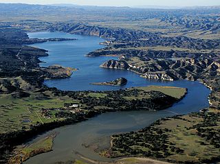
Cachuma Lake is a reservoir in the Santa Ynez Valley of central Santa Barbara County, California on the Santa Ynez River adjoining the north side of California State Route 154. The artificial lake was created by the construction of Bradbury Dam, a 201 ft (61 m) earth-fill structure built by the U.S. Bureau of Reclamation in 1953. Its surface area covers 3,100 acres (1,300 ha), with a maximum design capacity of 205,000 acre⋅ft (253,000,000 m3), but it is currently limited to 188,000 acre⋅ft (232,000,000 m3) due to sediment accumulation. The late-December 2022 and early-January 2023 storms dramatically raised the water level in the lake, from an average of 33% full to 100% full for the first time in 12 years.

New Melones Dam is an earth and rock filled embankment dam on the Stanislaus River, about 5 miles (8.0 km) west of Jamestown, California, United States, on the border of Calaveras County and Tuolumne County. The water impounded by the 625-foot-tall (191 m) dam forms New Melones Lake, California's fourth-largest reservoir, in the foothills of the Sierra Nevada east of the San Joaquin Valley. The dam serves mainly for irrigation water supply, and also provides hydropower generation, flood control, and recreation benefits.

Lake Berryessa is the largest lake in Napa County, California. This reservoir in the Vaca Mountains was formed following the construction of the Monticello Dam on Putah Creek in the 1950s. Since the early 1960s, this reservoir has provided water and hydroelectricity to the North Bay region of the San Francisco Bay Area.

San Luis Dam is a major earth-filled dam in Merced County, California, which forms San Luis Reservoir, the largest off-stream reservoir in the United States. The dam and reservoir are located in the Diablo Range to the east of Pacheco Pass and about 10 miles (16 km) west of Los Banos. San Luis Dam, a jointly-owned state and federal facility, stores more than 2 million acre feet (2.5 km3) of water for the California State Water Project and the federal Central Valley Project. Although the dam is located in the valley of San Luis Creek, the majority of its water comes from man-made aqueducts which are supplied from other rivers in Northern California.

The Santa Ynez River is one of the largest rivers on the Central Coast of California. It is 92 miles (148 km) long, flowing from east to west through the Santa Ynez Valley, reaching the Pacific Ocean at Surf, near Vandenberg Space Force Base and the city of Lompoc.

The California State Water Project, commonly known as the SWP, is a state water management project in the U.S. state of California under the supervision of the California Department of Water Resources. The SWP is one of the largest public water and power utilities in the world, providing drinking water for more than 27 million people and generating an average of 6,500 GWh of hydroelectricity annually. However, as it is the largest single consumer of power in the state itself, it has a net usage of 5,100 GWh.

Lake Casitas is a reservoir in Ventura County, California, built by the United States Bureau of Reclamation and completed in 1959. The project provides drinking water and water for irrigation. A secondary benefit is flood control. It was the venue for canoeing and rowing at the 1984 Summer Olympics.

Twitchell Reservoir is a reservoir in southern San Luis Obispo County and northern Santa Barbara County in California. The reservoir has a capacity of 197,756 acre⋅ft (243,928,000 m3) and is formed by Twitchell Dam on the Cuyama River about 66 miles (106 km) from its headwaters in the Chumash Wilderness Area. About 7 miles (11 km) below the dam, outflow joins the Sisquoc River near Gary, CA to form the Santa Maria River.

The Nimbus Dam is a base load hydroelectric dam on the American River near Folsom, California. Approximately 8,700 acre-feet (10,700 dam3) of water is retained by the dam. It is responsible for the impoundment of water from the American River to create the Lake Natoma reservoir. The dam stands 87 feet and spans 1,093 feet. The Nimbus powerplant consists of two generators. Each generator produces enough electrical power to power over 200,000 100-watt light bulbs, about 15,500 kilowatts of electrical power. Nimbus Dam consists of 18 radial gates, each with their own gate bays. These 18 gates today are the ones that were completed in 1955 along with the rest of the dam. Of the eighteen gates, four of them have had their coating system replaced. This protects the gates from a faster rate of corrosion. The other fourteen gates have the original coating.

Navajo Dam is a dam on the San Juan River, a tributary of the Colorado River, in northwestern New Mexico in the United States. The 402-foot (123 m) high earthen dam is situated in the foothills of the San Juan Mountains about 44 miles (71 km) upstream and east of Farmington, New Mexico. It was built by the U.S. Bureau of Reclamation (Reclamation) in the 1960s to provide flood control, irrigation, domestic and industrial water supply, and storage for droughts. A small hydroelectric power plant was added in the 1980s.

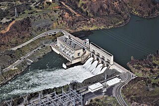
Folsom Dam is a concrete gravity dam on the American River of Northern California in the United States, about 25 mi (40 km) northeast of Sacramento. The dam is 340 ft (100 m) high and 1,400 ft (430 m) long, flanked by earthen wing dams. It was completed in 1955, and officially opened the following year.
Keswick Dam is a concrete gravity dam on the Sacramento River about 2 miles (3.2 km) northwest of Redding, California. Part of the U.S. Bureau of Reclamation's Central Valley Project, the dam is 157 feet (48 m) high and impounds the Keswick Reservoir, which has a capacity of 23,800 acre⋅ft (29,400,000 m3). The dam's power plant has three turbines with a generating capacity of 117 megawatts (MW), which, in 1992, was uprated from its original 75 MW. The dam and reservoir serve as an afterbay to regulate peaking power releases from the Shasta Dam upstream.

Lake Tahoe Dam is a concrete gravity dam on the Truckee River, at the outlet of Lake Tahoe in Placer County, California.
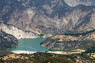
Gibraltar Dam is located on the Santa Ynez River, in southeastern Santa Barbara County, California, in the United States. Forming Gibraltar Reservoir, the dam is owned by the city of Santa Barbara. Originally constructed in 1920 and expanded in 1948, the dam and reservoir are located in a remote part of the Los Padres National Forest.

Salsipuedes Creek is a 9.9 miles (15.9 km) long stream, flowing north to join the Santa Ynez River just southeast of Lompoc in Santa Barbara County, California. Salsipuedes Creek, along with its major tributary, El Jaro Creek, is the largest tributary to the lower Santa Ynez River, shortly before the river reaches the Pacific Ocean.

Red Bluff Diversion Dam is a disused irrigation diversion dam on the Sacramento River in Tehama County, California, United States, southeast of the city of Red Bluff. Until 2013, the dam provided irrigation water for two canals that serve 150,000 acres (61,000 ha) of farmland on the west side of the Sacramento Valley. The dam and canals are part of the Sacramento Canals Unit of the Central Valley Project, operated by the U.S. Bureau of Reclamation. In 2013, the dam was decommissioned and the river allowed to flow freely through the site in order to protect migrating fish. A pumping plant constructed a short distance upstream now supplies water to the canal system.


