Brookfield, Missouri | |
---|---|
Coordinates: 39°47′07″N93°04′38″W / 39.78528°N 93.07722°W | |
Country | United States |
State | Missouri |
County | Linn |
Government | |
• Mayor | Lonnie Trentham |
Area | |
• Total | 4.29 sq mi (11.11 km2) |
• Land | 4.27 sq mi (11.07 km2) |
• Water | 0.02 sq mi (0.04 km2) |
Elevation | 764 ft (233 m) |
Population (2020) | |
• Total | 4,111 |
• Density | 961.86/sq mi (371.35/km2) |
Time zone | UTC-6 (Central (CST)) |
• Summer (DST) | UTC-5 (CDT) |
ZIP code | 64628 |
Area code | 660 |
FIPS code | 29-08650 [3] |
GNIS feature ID | 2393426 [2] |
Website | brookfieldcity.com |
Brookfield is a city in Linn County, Missouri, United States. The population was 4,111 at the 2020 census. [4]
Brookfield was surveyed in 1859 by John Wood Brooks, a native of Boston. John Wood Brooks is further remembered by the names of four Brookfield streets: John, Wood, Brooks, and Boston streets. [5] A post office called Brookfield has been in operation since 1860. [6]
According to the United States Census Bureau, the city has a total area of 4.29 square miles (11.11 km2), of which 4.27 square miles (11.06 km2) is land and 0.02 square miles (0.05 km2) is water. [7]
Climate data for Brookfield, Missouri (1991–2020 normals, extremes 1941–2018) | |||||||||||||
---|---|---|---|---|---|---|---|---|---|---|---|---|---|
Month | Jan | Feb | Mar | Apr | May | Jun | Jul | Aug | Sep | Oct | Nov | Dec | Year |
Record high °F (°C) | 74 (23) | 79 (26) | 86 (30) | 92 (33) | 98 (37) | 106 (41) | 116 (47) | 108 (42) | 109 (43) | 95 (35) | 83 (28) | 72 (22) | 116 (47) |
Mean maximum °F (°C) | 57.3 (14.1) | 65.4 (18.6) | 76.5 (24.7) | 83.2 (28.4) | 86.5 (30.3) | 92.4 (33.6) | 96.1 (35.6) | 96.6 (35.9) | 91.0 (32.8) | 84.0 (28.9) | 72.0 (22.2) | 60.4 (15.8) | 98.2 (36.8) |
Average high °F (°C) | 36.1 (2.3) | 41.6 (5.3) | 53.6 (12.0) | 64.9 (18.3) | 74.4 (23.6) | 83.3 (28.5) | 87.3 (30.7) | 86.1 (30.1) | 78.9 (26.1) | 67.3 (19.6) | 52.8 (11.6) | 40.7 (4.8) | 63.9 (17.7) |
Daily mean °F (°C) | 26.9 (−2.8) | 31.5 (−0.3) | 42.8 (6.0) | 53.6 (12.0) | 63.9 (17.7) | 73.3 (22.9) | 77.4 (25.2) | 75.5 (24.2) | 67.6 (19.8) | 55.9 (13.3) | 42.7 (5.9) | 31.8 (−0.1) | 53.6 (12.0) |
Average low °F (°C) | 17.7 (−7.9) | 21.5 (−5.8) | 31.9 (−0.1) | 42.2 (5.7) | 53.5 (11.9) | 63.4 (17.4) | 67.4 (19.7) | 64.9 (18.3) | 56.3 (13.5) | 44.5 (6.9) | 32.7 (0.4) | 22.9 (−5.1) | 43.2 (6.2) |
Mean minimum °F (°C) | −2.8 (−19.3) | 0.3 (−17.6) | 12.5 (−10.8) | 26.0 (−3.3) | 39.2 (4.0) | 49.6 (9.8) | 56.4 (13.6) | 54.1 (12.3) | 38.9 (3.8) | 28.3 (−2.1) | 15.6 (−9.1) | 0.0 (−17.8) | −9.4 (−23.0) |
Record low °F (°C) | −21 (−29) | −18 (−28) | −15 (−26) | 13 (−11) | 29 (−2) | 41 (5) | 46 (8) | 43 (6) | 27 (−3) | 16 (−9) | −7 (−22) | −24 (−31) | −24 (−31) |
Average precipitation inches (mm) | 1.50 (38) | 1.82 (46) | 2.90 (74) | 3.95 (100) | 5.53 (140) | 5.49 (139) | 4.92 (125) | 4.37 (111) | 3.99 (101) | 3.43 (87) | 2.52 (64) | 1.80 (46) | 42.22 (1,072) |
Average snowfall inches (cm) | 4.8 (12) | 5.9 (15) | 2.5 (6.4) | 0.2 (0.51) | 0.0 (0.0) | 0.0 (0.0) | 0.0 (0.0) | 0.0 (0.0) | 0.0 (0.0) | 0.1 (0.25) | 1.2 (3.0) | 4.2 (11) | 18.9 (48) |
Average precipitation days (≥ 0.01 in) | 7.2 | 7.5 | 9.5 | 11.6 | 12.5 | 11.4 | 9.6 | 8.8 | 7.7 | 8.7 | 7.9 | 7.4 | 109.8 |
Average snowy days (≥ 0.1 in) | 3.1 | 2.8 | 1.4 | 0.1 | 0.0 | 0.0 | 0.0 | 0.0 | 0.0 | 0.0 | 0.7 | 2.9 | 11.0 |
Source: NOAA (mean maxima/minima 1981–2010) [8] [9] |
Census | Pop. | Note | %± |
---|---|---|---|
1870 | 402 | — | |
1880 | 2,264 | 463.2% | |
1890 | 4,547 | 100.8% | |
1900 | 5,484 | 20.6% | |
1910 | 5,749 | 4.8% | |
1920 | 6,304 | 9.7% | |
1930 | 6,428 | 2.0% | |
1940 | 6,174 | −4.0% | |
1950 | 5,810 | −5.9% | |
1960 | 5,694 | −2.0% | |
1970 | 5,491 | −3.6% | |
1980 | 5,555 | 1.2% | |
1990 | 4,888 | −12.0% | |
2000 | 4,769 | −2.4% | |
2010 | 4,542 | −4.8% | |
2020 | 4,111 | −9.5% | |
U.S. Decennial Census [10] |
As of the census [11] of 2010, there were 4,542 people, 1,892 households, and 1,146 families living in the city. The population density was 1,063.7 inhabitants per square mile (410.7/km2). There were 2,280 housing units at an average density of 534.0 per square mile (206.2/km2). The racial makeup of the city was 95.4% White, 1.3% African American, 0.3% Native American, 0.3% Asian, 0.6% from other races, and 2.1% from two or more races. Hispanic or Latino of any race were 2.0% of the population.
There were 1,892 households, of which 30.8% had children under the age of 18 living with them, 43.3% were married couples living together, 12.5% had a female householder with no husband present, 4.7% had a male householder with no wife present, and 39.4% were non-families. 34.5% of all households were made up of individuals, and 16.4% had someone living alone who was 65 years of age or older. The average household size was 2.32 and the average family size was 2.96.
The median age in the city was 40.6 years. 25.8% of residents were under the age of 18; 7.1% were between the ages of 18 and 24; 21.6% were from 25 to 44; 25.1% were from 45 to 64; and 20.5% were 65 years of age or older. The gender makeup of the city was 45.9% male and 54.1% female.
As of the census [3] of 2000, there were 4,769 people, 2,058 households, and 1,234 families living in the city. The population density was 1,110.2 inhabitants per square mile (428.7/km2). There were 2,394 housing units at an average density of 557.3 per square mile (215.2/km2). The racial makeup of the city was 96.94% White, 1.26% African American, 0.36% Native American, 0.15% Asian, 0.13% from other races, and 1.17% from two or more races. Hispanic or Latino of any race were 0.94% of the population.
There were 2,058 households, out of which 27.2% had children under the age of 18 living with them, 44.8% were married couples living together, 11.4% had a female householder with no husband present, and 40.0% were non-families. 35.3% of all households were made up of individuals, and 20.7% had someone living alone who was 65 years of age or older. The average household size was 2.23 and the average family size was 2.86.
In the city, the population was spread out, with 24.1% under the age of 18, 7.2% from 18 to 24, 23.1% from 25 to 44, 20.8% from 45 to 64, and 24.9% who were 65 years of age or older. The median age was 42 years. For every 100 females, there were 83.4 males. For every 100 females age 18 and over, there were 77.9 males.
The median income for a household in the city was $25,753, and the median income for a family was $32,385. Males had a median income of $23,284 versus $19,004 for females. The per capita income for the city was $14,842. About 14.7% of families and 19.1% of the population were below the poverty line, including 28.7% of those under age 18 and 14.8% of those age 65 or over.
Brookfield R-III School District operates one elementary school, one middle school, Brookfield High School, and Brookfield Area Career Center. [12]
The town has a lending library, the Brookfield Public Library. [13]
Every Labor Day weekend, Brookfield hosts the Great Pershing Balloon Derby. Every fall the Brookfield Bulldogs play the Marceline Tigers in the annual Bell Game which is one of the oldest high school football rivalries in the United States. The Bell Game won a USA Today national contest for the nations best football rivalry in 2012. The Bell Game rivalry received 1,761,878 votes and won a $10,000 prize divided equally between Brookfield and Marceline. [14]
Every year Brookfield hosts Twin Parks Summer Festival, a festival that takes place in the Twin Parks and on Main Street. The Twin Parks Summer Festival marks the start of summer for families in and around Brookfield, with activities including craft vendors, a baby contest, games, and a concert on Main Street featuring prominent acts.
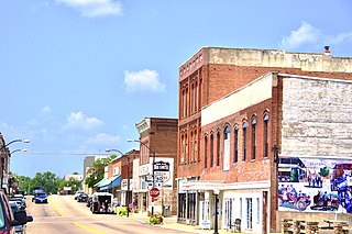
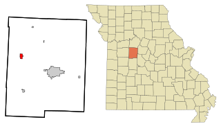
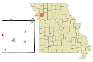
Linn County is a county located in the northern portion of the U.S. state of Missouri. As of the 2020 census, the population was 11,874. Its county seat is Linneus. The county was organized January 1, 1837 and named after U.S. Senator Lewis F. Linn of Missouri.
Cordes Lakes is a census-designated place (CDP) in Yavapai County, Arizona, United States. The population was 2,058 at the 2000 census. The Agua Fria National Monument lies to the east and south of the community and Arcosanti is to the north.
Lake Winnebago is a city in Cass County, Missouri, United States. The population was 1,131 at the 2010 census. It is part of the Kansas City metropolitan area.
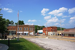
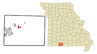
Stockton is a city in Cedar County, Missouri, United States. The population was 1,683 at the 2020 census. It is the county seat of Cedar County.
Willow Springs is a city in Howell County, Missouri, in the Ozark Mountains of the United States. The population was 2,164 at the 2020 census.
Waverly is a city in Lafayette County, Missouri, and part of the Kansas City metropolitan area within the United States. The population was 849 at the 2010 census.
Alton is a city and the county seat of Oregon County, Missouri, United States. The population was 707 at the 2020 census.
Steele is a city in southern Pemiscot County in the Missouri Bootheel of southeastern Missouri, United States. The population was 1,853 at the 2020 census.
La Monte is a city in Pettis County, Missouri, United States. The population was 1,140 at the 2010 census.
Parkville is a city in Platte County, Missouri, United States and is a part of the Kansas City Metropolitan Area. The population was 7,177 at the 2020 census. Parkville is known for its antique shops, art galleries, and historic downtown. The city is home to Park University, English Landing Park, Platte Landing Park, and the National Golf Club of Kansas City. Large neighborhoods in Parkville include: Riss Lake, The National, Thousand Oaks, Creekside, Parkville Heights, River Hills, Riverchase, The Bluffs, Downtown, and Pinecrest.
Benton is a city in Scott County, Missouri, United States. The population was 863 at the 2010 census. It is the county seat of Scott County.
Green Park is a city in St. Louis County, Missouri, United States. The population was 2,622 at the 2010 census.
Manchester is a city in St. Louis County, Missouri, United States. The population was 18,333 at the 2020 census.
Galena is a city and the county seat in Stone County, Missouri, United States. The population was 455 at the 2020 census. Galena is part of the Branson, Missouri Micropolitan Statistical Area.
Hartville is a city in Wright County, Missouri, United States. The population was 594 at the 2020 census. It is the county seat of Wright County.
Mount Vernon is a city in and the county seat of Lawrence County, Missouri, United States. The population was 4,575 as of the 2010 census. It was estimated to be 4,960 by the City of Mount Vernon on July 1, 2020.
Forsyth is a city in Taney County, Missouri, United States. The population was 2,730 at the 2020 census. It is the county seat of Taney County. The town is part of the Branson, Missouri Micropolitan Statistical Area. Forsyth is located on Lake Taneycomo on U.S. Route 160.
Elm Grove is a village in Waukesha County, Wisconsin, United States. The population was 6,524 at the 2020 census. Elm Grove was named as America's best suburb by Business Insider in October 2014.
North English is a city located mainly in Iowa county with a small portion in Keokuk county in the U.S. state of Iowa. The population was 1,065 at the time of the 2020 census. It is named for the English River.
Gower is a city in Buchanan and Clinton counties in the U.S. state of Missouri and is part of the Kansas City metropolitan area. The population was 1,526 at the 2010 census.