Brooksville, Mississippi

Last updated

Brooksville, Mississippi
Noxubee County Mississippi Incorporated and Unincorporated areas Brooksville Highlighted.svg
Location of Brooksville, Mississippi
Usa edcp location map.svg
Red pog.svg
Brooksville, Mississippi
Location in the United States
Coordinates: 33°13′58″N88°34′54″W / 33.23278°N 88.58167°W / 33.23278; -88.58167
Country United States
State Mississippi
County Noxubee
Area
[1]
  Total1.59 sq mi (4.12 km2)
  Land1.59 sq mi (4.12 km2)
  Water0.00 sq mi (0.00 km2)
Elevation
279 ft (85 m)
Population
 (2020)
  Total915
  Density575.83/sq mi (222.36/km2)
Time zone UTC-6 (Central (CST))
  Summer (DST) UTC-5 (CDT)
ZIP code
39739
Area code 662
FIPS code 28-08980
GNIS feature ID0667603
Website www.brooksvillems.org

Brooksville is a town in Noxubee County, Mississippi, United States. The population was 1,223 at the 2010 census.

Contents

The Sam D. Hamilton Noxubee National Wildlife Refuge is located west of the town, and the Black Prairie Wildlife Management Area is located to the north. [2]

History

The town's name comes from the several brooks which flow nearby. [3]

A post office was established in 1846, and the town was incorporated in 1860. [4]

Brooksville was a stop on the Mobile and Ohio Railroad, built in the 1850s. [4]

Brooksville has a large Holdemann Mennonite community. [5] [6]

Geography

Brooksville is located at 33°13′58″N88°34′54″W / 33.23278°N 88.58167°W / 33.23278; -88.58167 (33.232853, -88.581600). [7]

According to the United States Census Bureau, the town has a total area of 1.0 square mile (2.6 km2), all land.

Demographics

Historical population
CensusPop.Note
1880 284
1890 42449.3%
1900 61244.3%
1910 85038.9%
1920 8540.5%
1930 8752.5%
1940 764−12.7%
1950 8197.2%
1960 8574.6%
1970 97814.1%
1980 1,0386.1%
1990 1,0985.8%
2000 1,1827.7%
2010 1,2233.5%
2020 915−25.2%
U.S. Decennial Census [8]

2020 census

Brooksville Racial Composition [9]
RaceNum.Perc.
White 18620.33%
Black or African American 69275.63%
Native American 10.11%
Asian 101.09%
Other/Mixed 121.31%
Hispanic or Latino 141.53%

As of the 2020 United States Census, there were 915 people, 448 households, and 303 families residing in the town.

2000 census

At the census [10] of 2000, there were 1,182 people, 439 households, and 305 families residing in the town. The population density was 1,189.1 inhabitants per square mile (459.1/km2). There were 480 housing units at an average density of 482.9 per square mile (186.4/km2). The racial makeup of the town was 19.12% White, 79.61% African American, 0.17% Asian, and 1.10% from two or more races. Hispanic or Latino of any race were 1.10% of the population.

There were 439 households, out of which 35.8% had children under the age of 18 living with them, 31.2% were married couples living together, 33.7% had a female householder with no husband present, and 30.5% were non-families. 28.2% of all households were made up of individuals, and 13.4% had someone living alone who was 65 years of age or older. The average household size was 2.69 and the average family size was 3.30.

In the town, the population was spread out, with 31.7% under the age of 18, 11.5% from 18 to 24, 26.6% from 25 to 44, 16.8% from 45 to 64, and 13.4% who were 65 years of age or older. The median age was 30 years. For every 100 females, there were 88.8 males. For every 100 females age 18 and over, there were 76.6 males.

The median income for a household in the town was $16,146, and the median income for a family was $20,804. Males had a median income of $26,513 versus $17,500 for females. The per capita income for the town was $9,001. About 38.0% of families and 44.4% of the population were below the poverty line, including 57.9% of those under age 18 and 25.2% of those age 65 or over.

In 2010, Brooksville had the 24th-lowest median household income of all places in the United States with a population over 1,000. [11]

Economy

Peco Foods has had a poultry processing plant in Brooksville since 1993, which employs 232 workers. [12]

Education

The town of Brooksville is served by the Noxubee County School District.

Notable people

Related Research Articles

<span class="mw-page-title-main">Sumter County, Alabama</span> County in Alabama, United States

Sumter County is a county located in the west central portion of Alabama. At the 2020 census, the population was 12,345. Its county seat is Livingston. Its name is in honor of General Thomas Sumter of South Carolina. The University of West Alabama is in Livingston.

<span class="mw-page-title-main">Winston County, Mississippi</span> County in Mississippi, United States

Winston County is a county located in the U.S. state of Mississippi. In the 2020 census, the population was 17,714. Its county seat is Louisville. The county is named for Louis Winston (1784–1824), a colonel in the militia, a prominent lawyer, and a judge of the Mississippi Supreme Court.

<span class="mw-page-title-main">Warren County, Mississippi</span> County in Mississippi, United States

Warren County is a county located in the U.S. state of Mississippi. Its western border is formed by the Mississippi River. As of the 2020 census, the population was 44,722. Its county seat is Vicksburg. Established by legislative act of December 22, 1809, Warren County is named for American Revolutionary War officer Joseph Warren.

<span class="mw-page-title-main">Sharkey County, Mississippi</span> County in Mississippi, United States

Sharkey County is a county located in the U.S. state of Mississippi. Part of the eastern border is formed by the Yazoo River. According to the 2020 census, the population was 3,800, making it the second-least populous county in Mississippi, after Issaquena County. Its county seat is Rolling Fork. The county is named after William L. Sharkey, the provisional Governor of Mississippi in 1865.

<span class="mw-page-title-main">Oktibbeha County, Mississippi</span> County in Mississippi, United States

Oktibbeha County is a county in the east central portion of the U.S. state of Mississippi. As of the 2020 census the population was 51,788. The county seat is Starkville. The county's name is derived from a local Native American word meaning either "bloody water" or "icy creek". The Choctaw had long occupied much of this territory prior to European exploration and United States acquisition.

<span class="mw-page-title-main">Noxubee County, Mississippi</span> County in Mississippi, United States

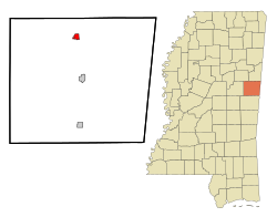
Noxubee County is a county located in the U.S. state of Mississippi. As of the 2020 census, its population was 10,285. Its county seat is Macon. The name is derived from the Choctaw word nakshobi meaning "to stink".

<span class="mw-page-title-main">Lowndes County, Mississippi</span> County in Mississippi, United States

Lowndes County is a county on the eastern border of the U.S. state of Mississippi. As of the 2020 United States Census, the population was 58,879. Its county seat is Columbus. The county is named for U.S. Congressman William Jones Lowndes.

<span class="mw-page-title-main">Humphreys County, Mississippi</span> County in Mississippi, United States

Humphreys County is a county located in the U.S. state of Mississippi. As of the 2020 census, the population was 7,785. Its county seat is Belzoni. The county is named for Benjamin G. Humphreys. Humphreys County is Mississippi's newest county, having been formed in 1918. Humphreys County is located in the Mississippi Delta region.

<span class="mw-page-title-main">Alcorn County, Mississippi</span> County in Mississippi, United States

Alcorn County is a county located in the northeastern portion of the U.S. state of Mississippi. As of the 2020 census, the population was 34,740. Its county seat is Corinth. The county is named in honor of Governor James L. Alcorn.

<span class="mw-page-title-main">Brooksville, Maine</span> Town in the state of Maine, United States

Brooksville is a town on Penobscot Bay in Hancock County, Maine, United States. As of the 2020 census, the town population was 935. It contains the villages of North Brooksville, South Brooksville, West Brooksville, Brooksville Corner, and Harborside.

<span class="mw-page-title-main">Winstonville, Mississippi</span> Town in Mississippi, United States

Winstonville is a town in Bolivar County, Mississippi, United States. Per the 2020 census, the population was 153.

<span class="mw-page-title-main">Pachuta, Mississippi</span> Town in Mississippi, United States

Pachuta is a town in Clarke County, Mississippi, United States. The population was 261 at the 2010 census.

<span class="mw-page-title-main">Artesia, Mississippi</span> Town in Mississippi, United States

Artesia is a town in Lowndes County, Mississippi. The population was 304 at the 2020 census, down from 440 at the 2010 census.

<span class="mw-page-title-main">Hatley, Mississippi</span> Town in Mississippi, United States

Hatley is a town in Monroe County, Mississippi. The population was 495 at the 2020 census.

<span class="mw-page-title-main">Macon, Mississippi</span> City in Mississippi, United States

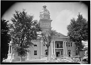
Macon is a city in Noxubee County, Mississippi along the Noxubee River. The population was 2,768 at the 2010 census. It is the county seat of Noxubee County.

<span class="mw-page-title-main">Shuqualak, Mississippi</span> Town in Mississippi, United States

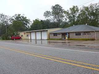
Shuqualak, pronounced "sugar lock", is a town in Noxubee County, Mississippi, United States. As of the 2020 census, the population was 399. That is down from 501 from the 2010 census. Three locations in Shuqualak, including most of the downtown area, are included on the National Register of Historic Places.

<span class="mw-page-title-main">Meno, Oklahoma</span> Town in Oklahoma, United States

Meno is a town in Major County, Oklahoma, United States. The population was 235 at the 2010 census, a 20.5 percent increase from the figure of 195 in 2000.

<span class="mw-page-title-main">Brooksville, Oklahoma</span> Town in Oklahoma, United States

Brooksville is a town in Pottawatomie County, Oklahoma, United States. It is one of the thirteen existing all-black towns in Oklahoma. The population was 63 at the 2010 census, a 30 percent decline from the figure of 90 in 2000.

<span class="mw-page-title-main">Corn, Oklahoma</span> Town in Oklahoma, United States

Corn is a town in Washita County, Oklahoma, United States. The population was 503 at the 2010 census.

<span class="mw-page-title-main">Starkville–Columbus, MS CSA</span> Combined Statistical Area in Mississippi, United States

The Starkville–Columbus, MS Combined Statistical Area was formerly known as Columbus–West Point was defined as consisting of Clay and Lowndes counties in northeastern Mississippi, which were separately treated as the West Point Micropolitan Statistical Area and Columbus Micropolitan Statistical Area, respectively. As of the 2000 census, the CSA had a population of 83,565.

References

  1. "2020 U.S. Gazetteer Files". United States Census Bureau. Retrieved July 24, 2022.
  2. "Black Prairie". Mississippi Department of Wildlife, Fisheries and Parks. Archived from the original on May 14, 2014. Retrieved March 2, 2014.
  3. Capace, Nancy (2001). Encyclopedia of Mississippi. North American Book. ISBN   9780403096039.
  4. 1 2 Howe, Tony. "Brooksville, Mississippi". Mississippi Rails. Retrieved March 2, 2014.
  5. "Communities". Noxubee County Economic and Community Development Alliance. Archived from the original on December 28, 2013. Retrieved March 2, 2014.
  6. Sisson, Carmen K (March 16, 2012). "More than 1,000 Mennonites gather at Trotter for North American convention" . Retrieved December 20, 2018.
  7. "US Gazetteer files: 2010, 2000, and 1990". United States Census Bureau. February 12, 2011. Retrieved April 23, 2011.
  8. "Census of Population and Housing". Census.gov. Retrieved June 4, 2015.
  9. "Explore Census Data". data.census.gov. Retrieved December 8, 2021.
  10. "U.S. Census website". United States Census Bureau . Retrieved January 31, 2008.
  11. "US Census". Archived from the original on February 12, 2020. Retrieved January 18, 2014.
  12. "Existing Business & Industry". Noxubee County Economic and Community Development Alliance. Archived from the original on December 28, 2013. Retrieved March 2, 2014.
  13. History, Mississippi Department of Archives and (October 27, 1924). "The Official and Statistical Register of the State of Mississippi". Department of Archives and History. p. 177 via Google Books.
  14. "Dave Madison". Baseball Reference. Retrieved March 2, 2014.
  15. "Carl L. Mickens". billstatus.ls.state.ms.us. Retrieved January 18, 2024.
  16. Rule, Sheila (August 27, 1992). "Frederick O'Neal, 86, Actor and Equity President". New York Times.