Brownsburg, Indiana

Last updated

Brownsburg, Indiana
The Arbuckle.jpg
North Green Street
Nicknames: 
bburg
Motto: 
"Community on the Move"
Hendricks County Indiana Incorporated and Unincorporated areas Brownsburg Highlighted 1808416.svg
Location of Brownsburg in Hendricks County, Indiana.
Coordinates: 39°50′31″N86°23′04″W / 39.84194°N 86.38444°W / 39.84194; -86.38444
Country United States
State Indiana
County Hendricks
Government
  Town Council PresidentTravis Tschaenn[ citation needed ]
Area
[1]
  Total16.35 sq mi (42.36 km2)
  Land16.27 sq mi (42.13 km2)
  Water0.09 sq mi (0.22 km2)
Elevation
[2]
879 ft (268 m)
Population
 (2020)
  Total30,068
  Density1,780.98/sq mi (687.63/km2)
Time zone UTC-5 (EST)
  Summer (DST) UTC-4 (EDT)
ZIP code
46112
Area code 317
FIPS code 18-08416 [3]
GNIS feature ID2396611 [2]
Website www.brownsburg.org

Brownsburg is a town in Hendricks County, Indiana, United States. The population was recorded to be 21,285 residents at the 2010 Census. [4] In 2020, the population was recorded as 28,973 residents. [5]

Contents

History

Looking east on Main Street Main Street Brownsburg, IN.jpg
Looking east on Main Street

Brownsburg was first settled in 1824 by James B. Brown. Delaware Indians lived in what is now called Lincoln Township, along White Lick Creek, which was then called "Wa-pe-ke-way" or "White Salt".

Four years later, the first log schoolhouse was built in Brown Township. Brown and additional settlers arrived once a stagecoach line was established along a road built in 1820 connecting to Indianapolis. William Harris settled in the area north of what is now Main Street, selling sections of woods to incoming pioneers. This gave the town its original name of Harrisburg in 1835. A post office was established in 1836 under the name of Harrisburg but was later changed to Brownsburg, [6] since the name Harrisburg was being used by a post office in another Indiana county.

From 1840 to 1870, Brownsburg tripled in size, increased from six to sixteen acres, and added its first church. The town's first election was held in 1848. In 1863, it was divided into Brown Township and Lincoln Township. [7]

In 1985, part of the movie Hoosiers was filmed in the former College Avenue Gym. [8]

Brownsburg Town Hall and Police Station Brownsburg Town Hall and Police Station.jpg
Brownsburg Town Hall and Police Station

Geography

According to the 2010 census, Brownsburg has a total area of 11.16 square miles (28.90 km2), of which 11.08 square miles (28.70 km2) (or 99.28%) is land and 0.08 square miles (0.21 km2) (or 0.72%) is water. [9] [10] White Lick Creek, a tributary of the White River, flows from north to south through the town, passing just west of the town center.

Demographics

Historical population
CensusPop.Note
1850 132
1870 551
1880 66721.1%
1890 623−6.6%
1900 6768.5%
1910 87629.6%
1920 1,06321.3%
1930 1,042−2.0%
1940 1,1369.0%
1950 1,57838.9%
1960 4,478183.8%
1970 5,75128.4%
1980 6,2428.5%
1990 7,62822.2%
2000 14,52090.4%
2010 21,28546.6%
2020 28,97336.1%
Source: US Census Bureau

2010 census

At the 2010 census there were 21,285 people, 7,948 households, and 5,816 families in the town. The population density was 1,921.0 inhabitants per square mile (741.7/km2). There were 8,376 housing units at an average density of 756.0 per square mile (291.9/km2). The racial makeup of the town was 93.4% White, 2.2% African American, 0.1% Native American, 1.6% Asian, 0.1% Pacific Islander, 1.2% from other races, and 1.4% from two or more races. Hispanic or Latino of any race were 3.0%. [11]

Of the 7,948 households, 40.9% had children under the age of 18 living with them, 58.7% were married couples living together, 10.5% had a female householder with no husband present, 4.0% had a male householder with no wife present, and 26.8% were non-families. 22.4% of households were one person and 8.5% were one person aged 65 or older. The average household size was 2.64 and the average family size was 3.11.

The median age in the town was 36 years. 28.4% of residents were under the age of 18; 6.8% were between the ages of 18 and 24; 28.8% were from 25 to 44; 24.1% were from 45 to 64, and 12% were 65 or older. The gender makeup of the town was 48.0% male and 52.0% female.

Gateway and trailhead at N. Green Street N Green Street shelter house.jpg
Gateway and trailhead at N. Green Street

2000 census

At the 2000 census, there were 14,520 people, & 5,366 households residing in the town. The population density was 1,983.5 inhabitants per square mile (765.8/km2). There were 5,574 housing units at an average density of 761.4 per square mile (294.0/km2). The racial makeup of the town was 97.44% White, 0.32% African American, 0.17% Native American, 0.78% Asian, 0.08% Pacific Islander, 0.35% from other races, and 0.86% from two or more races. Hispanic or Latino of any race were 1.18%. [3] Of the 5,366 households, 41.8% had children under the age of 18 living with them, 64.0% were married couples living together, 8.6% had a female householder with no husband present, and 24.6% were non-families. 20.8% of households were one person and 8.2% were one person aged 65 or older. The average household size was 2.65 and the average family size was 3.10.

The age distribution was: 29.2% <18, 6.8% from 18 to 24, 34.5% from 25 to 44, 17.9% from 45 to 64, and 11.7% 65 or older. The median age was 33 years. For every 100 females, there were 92.7 males. For every 100 females aged 18 and over, there were 89.0 males.

The median household income was $63,629 and the median income for a family was $74,245. Males had a median income of $56,240 versus $38,685 for females. The per capita income for the town was $33,196. About 1.5% of families and 2.3% of the population were below the poverty line, including 1.3% of those under age 18 and 4.4% of those age 65 or over.

Education

Brownsburg Public Library Brownsburg Public Library.jpg
Brownsburg Public Library

Public schools

Brownsburg Community School Corporation maintains all public schools in Brownsburg. [12]

Private schools

Public library

The town has a library, the Brownsburg Public Library. [14]

Notable people

Neighboring communities

See also

Related Research Articles

<span class="mw-page-title-main">St. Leon, Indiana</span> Town in Indiana, United States

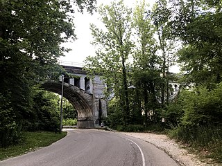
St. Leon or Saint Leon is a town in Kelso Township, Dearborn County, Indiana, United States. The population was 678 at the 2010 census.

<span class="mw-page-title-main">Worthington, Indiana</span> Town in Indiana, United States

Worthington is a town in Jefferson Township, Greene County, Indiana, United States. The population was 1,463 at the 2010 United States Census. It is part of the Bloomington, Indiana, Metropolitan Statistical Area.

<span class="mw-page-title-main">Wilkinson, Indiana</span> Town in Indiana, United States

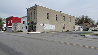
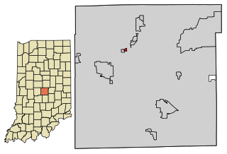
Wilkinson is a town in Brown Township, Hancock County, Indiana, United States. The population was 449 at the 2010 census.

<span class="mw-page-title-main">Lanesville, Indiana</span> Town in Indiana, United States

Lanesville is a town in Franklin Township, Harrison County, Indiana, United States. The population was 935 at the 2010 census.

<span class="mw-page-title-main">Avon, Indiana</span> Town in Indiana, United States

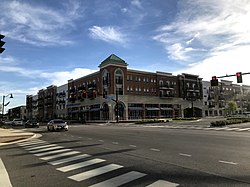
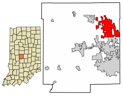
Avon is a town in Washington Township, Hendricks County, Indiana, United States. The population was 21,474 at the 2020 census. It is part of the Indianapolis metropolitan area.

<span class="mw-page-title-main">Stilesville, Indiana</span> Town in Indiana, United States

Stilesville is a town in Franklin Township, Hendricks County, Indiana, United States. The population was 316 at the 2010 Census.

<span class="mw-page-title-main">Brownstown, Indiana</span> Town in Indiana, United States

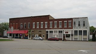
Brownstown is a town within Brownstown Township and the county seat of Jackson County, Indiana, United States. The population was 2,947 at the 2010 census. It was named for Jacob Brown, a general of the War of 1812.

<span class="mw-page-title-main">Sandborn, Indiana</span> Town in Indiana, United States

Sandborn is a town in Vigo Township, Knox County, Indiana, United States. The population was 359 at the 2020 census. It is the home of the annual Black Creek Festival.

<span class="mw-page-title-main">Sidney, Indiana</span> Town in Indiana, United States

Sidney is a town in Jackson Township, Kosciusko County, in the U.S. state of Indiana. The population was 83 at the 2010 census.

<span class="mw-page-title-main">Wanatah, Indiana</span> Town in Indiana, United States

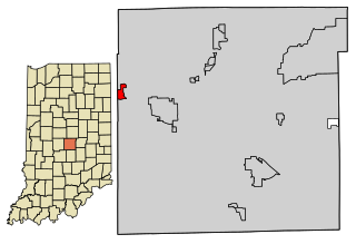
Wanatah is a town in LaPorte County, Indiana, United States. The population was 1,048 at the 2010 census.

<span class="mw-page-title-main">Paragon, Indiana</span> Town in Indiana, United States

Paragon is a town in Ray Township, Morgan County, in the U.S. state of Indiana. The population was 556 at the 2020 census, down from 659 in 2010.

<span class="mw-page-title-main">Paoli, Indiana</span> Town in Indiana, United States

Paoli is a town within Paoli Township and the county seat of Orange County, in the U.S. state of Indiana. The population was 3,677 at the 2010 census.

<span class="mw-page-title-main">Clear Lake, Indiana</span> Town in Indiana, United States

Clear Lake is a town located in the northeast corner of Steuben County, Indiana, in Clear Lake Township. As such, is the northeasternmost community in the State of Indiana. The population was 339 at the 2010 census.

<span class="mw-page-title-main">Farmersburg, Indiana</span> Town in Indiana, United States

Farmersburg is a town in Curry Township, Sullivan County, Indiana, United States. The population was 1,118 at the 2010 census. It is part of the Terre Haute Metropolitan Statistical Area. The town is adjacent to the Vigo County line and is overshadowed by several large TV and radio transmitter towers.

<span class="mw-page-title-main">Brookston, Indiana</span> Town in Indiana, United States

Brookston is a town in Prairie Township, White County, in the U.S. state of Indiana. The population was 1,554 as of the 2010 United States Census.

<span class="mw-page-title-main">Villa Hills, Kentucky</span> City in Kentucky, United States

Villa Hills is a home rule-class city in Kenton County, Kentucky along the Ohio River. The population was 7,310 at the 2020 census.

<span class="mw-page-title-main">Pitcher, New York</span> Town in New York, United States

Pitcher is a town in Chenango County, New York, United States. The population was 803 at the 2010 census. The town is named after Nathaniel Pitcher, the eighth governor of New York. The town is on the western border of Chenango County, west of the city of Norwich.

<span class="mw-page-title-main">Spring Hill, Indiana</span> Town in Indiana, United States

Spring Hill is a town in Marion County, Indiana, United States. The population was 95 at the 2020 census. It has existed as an "included town" since 1970, when it was incorporated into Indianapolis as part of Unigov. It is part of Indianapolis, but retains town governmental powers under IC 36-3-1-11.

<span class="mw-page-title-main">Wynnedale, Indiana</span> Town in Indiana, United States

Wynnedale is a town in Washington Township, Marion County, Indiana, United States. The population was 215 at the 2020 census. It has existed as an "included town" since 1970, when it was incorporated into Indianapolis as part of Unigov. It is part of Indianapolis, but retains a functioning town government under IC 36-3-1-11.

<span class="mw-page-title-main">Clermont, Indiana</span> Town in Indiana, United States

Clermont is a town in Pike and Wayne townships of Marion County, Indiana, United States. The population was 1,384 at the 2020 census. It has existed as an "included town" since 1970, when it was incorporated into Indianapolis as part of Unigov. It is legally part of Indianapolis, while retaining a town government under IC 36-3-2-5. The city is known for hosting Lucas Oil Raceway at Indianapolis, consisting of one of the nation's premier short-track ovals and also the premier American drag racing event, the NHRA U.S. Nationals.

References

  1. "2020 U.S. Gazetteer Files". United States Census Bureau. Retrieved March 16, 2022.
  2. 1 2 U.S. Geological Survey Geographic Names Information System: Brownsburg, Indiana
  3. 1 2 "U.S. Census website". United States Census Bureau . Retrieved January 31, 2008.
  4. "U.S Census Bureau American Fact Finder". Archived from the original on March 11, 2015.
  5. "Explore Census Data". data.census.gov. Retrieved July 8, 2023.
  6. "About the Town of Brownsburg | Brownsburg, IN". www.brownsburg.org. Retrieved November 28, 2022.
  7. "History of Brownsburg". Town of Brownsburg. Retrieved July 15, 2020.
  8. "Filming Sites". The Hoosiers Archive. Retrieved July 15, 2020.
  9. "G001 - Geographic Identifiers - 2010 Census Summary File 1". United States Census Bureau. Archived from the original on February 13, 2020. Retrieved July 13, 2015.
  10. "US Gazetteer files: 2010, 2000, and 1990". United States Census Bureau. February 12, 2011. Retrieved April 23, 2011.
  11. "U.S. Census website". United States Census Bureau . Retrieved December 11, 2012.
  12. "BCSC Welcome / Home". www.brownsburg.k12.in.us. Retrieved July 8, 2023.
  13. "St. Malachy Catholic School, Brownsburg, Indiana". Saint Malachy Parish. Retrieved July 1, 2020.
  14. "Public Library Directory 2020" (PDF). Indiana State Library. p. 27. Retrieved September 18, 2020.
  15. "Chloé Dygert". Team USA. United States Olympic & Paralympic Committee. Archived from the original on July 8, 2016.
  16. "Chris Estridge". 2011 Men's Soccer Roster. Indiana University Athletics. 2011. Retrieved September 18, 2020.
  17. "Brownsburg People: Pitchers, Racers, and Quarterbacks". FunCityFinder. Retrieved October 10, 2018.
  18. "Mike Vanderjagt: Colts Kicker from Canada". FunCityFinder. Retrieved October 10, 2018.