
The Buller River is a river in the South Island of New Zealand. The Buller has the highest flow of any river in the country during floods, though it is only the 13th longest river; it runs for 177 km (110 mi) from Lake Rotoiti through the Buller Gorge and into the Tasman Sea near the town of Westport. A saddle at 710 m (2,330 ft) separates the Buller from the Motupiko River and that is divided from the Wairau River by a 695 m (2,280 ft) saddle, both aligned along the Alpine Fault, as is the top of the Buller valley.
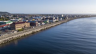
Greymouth is the largest town in the West Coast region in the South Island of New Zealand, and the seat of the Grey District Council. The population of the whole Grey District is 14,250, which accounts for 43% of the West Coast's inhabitants. The Greymouth urban area had an estimated population of 8,340. A large proportion of the District, 65%, is part of the Conservation Estate owned and managed by the Department of Conservation making Greymouth a natural centre for walkers and trampers.
A mining accident is an accident that occurs during the process of mining minerals or metals. Thousands of miners die from mining accidents each year, especially from underground coal mining, although accidents also occur in hard rock mining. Coal mining is considered much more hazardous than hard rock mining due to flat-lying rock strata, generally incompetent rock, the presence of methane gas, and coal dust. Most of the deaths these days occur in developing countries, and rural parts of developed countries where safety measures are not practiced as fully. A mining disaster is an incident where there are five or more fatalities.
Denniston is a small settlement, 15 kilometres east of Westport, on the West Coast of the South Island of New Zealand. It is situated on the Denniston Plateau, 600 metres (2,000 ft) above sea level in the Papahaua Ranges.
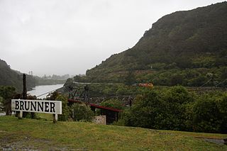
Brunner, originally called Brunnerton, is a town in the northwest of New Zealand's South Island. It is 12 kilometres (7 mi) east of Greymouth, on the south bank of the Grey River. It is on the Midland Line railway near its junction with the Stillwater–Westport Line (SWL) in neighbouring Stillwater. Passenger trains ceased running along the SWL to Reefton and Westport in 1967, but the TranzAlpine runs the length of the Midland Line from Christchurch to Greymouth and it continues to stop in Brunner.

The Stillwater Ngākawau Line (SNL), formerly the Stillwater–Westport Line (SWL) and the Ngakawau Branch, is a secondary main line, part of New Zealand's national rail network. It runs between Stillwater and Ngakawau via Westport on the West Coast of the South Island. It was one of the longest construction projects in New Zealand's history, with its first section, at the south end, opened in 1889, and the beginnings of the Ngākawau Branch, at its Westport end, in 1875. The full line was completed in 1942. The only slower railway projects were Palmerston North to Gisborne, 1872 to 1942, and the Main North Line to Picton, 1872 to 1945.
Stillwater is a town in the South Island of New Zealand east of Greymouth on the banks of the Grey River, at the confluence with the Arnold River, in the Grey District of the West Coast, next to Brunner. There is also a Stillwater, Auckland in the North Island.
The Rewanui Branch, sometimes referred to as the Rewanui Incline and known as the Point Elizabeth Branch in its early years, was a branch line railway located in the West Coast region of New Zealand's South Island. It branched from the Midland Line near its western terminus in Greymouth and ran up to Rewanui in the Paparoa Ranges. The branch closed in 1985 but the first six kilometres to Runanga remain in operation as part of the Rapahoe Branch.

Seddonville is a lightly populated locality on the West Coast of New Zealand's South Island. It is most famous for the historical role it played in New Zealand's coal mining industry.
The Pike River Mine is a coal mine formerly operated by Pike River Coal 46 km (29 mi) north-northeast of Greymouth in the West Coast Region of New Zealand's South Island. It is the site of the Pike River Mine disaster that occurred on 19 November 2010, leading to the deaths of 29 men whose remains have not been recovered. The mine and its assets are owned by the Department of Conservation, whom, on 1 July 2022, assumed ownership and management following the dissolution of the Pike River Recovery Agency. The former mine site and its surrounding land are a part of Paparoa National Park.

Pike River Coal Ltd was a mining company listed on the New Zealand and Australian stock exchanges. Its primary operation was the Pike River Mine, the site of a mining disaster with 29 deaths on 19 November 2010.

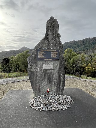
The Brunner Mine disaster happened at 9:30 am on Thursday 26 March 1896, when an explosion deep in the Brunner Mine, in the West Coast region of New Zealand, killed all 65 miners below ground. The Brunner Mine disaster is the deadliest mining disaster in New Zealand's history.

Mining in New Zealand began when the Māori quarried rock such as argillite in times prior to European colonisation. Mining by Europeans began in the latter half of the 19th century.

The Tyneside Mine was a coal mine on the West Coast of the South Island in New Zealand. The Tyneside Mine was one of several mines situated on the banks of the Grey River, at an area known as "Coal Gorge" between the townships of Stillwater and Taylorville.
The Strongman Mine was an underground coal mine north of Greymouth on the West Coast of New Zealand from 1938 to 2003.
The Pike River Mine disaster was a coal mining accident that began on 19 November 2010 in the Pike River Mine, 46 km (29 mi) northeast of Greymouth, in the West Coast region of New Zealand's South Island following a methane explosion at approximately 3:44 pm. The accident resulted in the deaths of 29 miners.

The Paparoa Track is a 55.7 km (34.6 mi) shared hiking and mountain biking track located in Paparoa National Park in the South Island of New Zealand. The track was created as a memorial for the 29 miners who lost their lives in the Pike River Mine disaster. The track is the tenth Great Walk to be created and has been fully open since 1 March 2020. It was the first addition to the Great Walks in 25 years.
The Brunner Borough was a borough on New Zealand's West Coast from 1887 to 1971. It was formed from an area that belonged to Grey County and, at disestablishment, merged back into Grey County.

New Zealand coal reserves are in excess of 15 billion tonnes, mainly in Waikato, Taranaki, West Coast, Otago and Southland. Over 80% of the reserves are in Southland lignite deposits. These were worth $100 billion in 2010.

