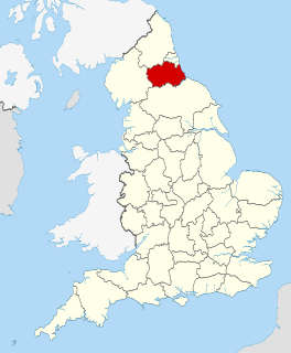
North East England is one of nine official regions of England at the first level of ITL for statistical purposes. The region covers an area of 8,592 km2 and in 2019 had a recorded population of nearly 2.7 million. There are four counties in the region: County Durham; Tyne and Wear; Northumberland and part of North Yorkshire. The largest settlements are Newcastle upon Tyne, Middlesbrough, Sunderland, Gateshead, Darlington and Hartlepool. There are three conurbations in the region: Tyneside ; Wearside ; and Teesside. Only three settlements in the region have city status: Newcastle upon Tyne, Sunderland and Durham.

Tyne and Wear is a metropolitan county in North East England, situated around the mouths of the rivers Tyne and Wear. It was created in 1974, by the Local Government Act 1972, along with five metropolitan boroughs of Gateshead, Newcastle upon Tyne, Sunderland, North Tyneside and South Tyneside. It is bordered by Northumberland to the north and Durham to the south; the county boundary was formerly split between these counties with the border as the River Tyne.

South Tyneside is a metropolitan borough in the metropolitan county of Tyne and Wear, North East England.

North Tyneside is a metropolitan borough in the metropolitan county of Tyne and Wear, England. It forms part of the greater Tyneside conurbation. North Tyneside Council is headquartered at Cobalt Park, Wallsend.

County Durham, officially simply Durham, is a ceremonial county in North East England. The ceremonial county spawned from the historic County Palatine of Durham in 1853. In 1996, the county gained part of the abolished ceremonial county of Cleveland. The largest settlement in the county is Darlington, followed by Hartlepool, and then Stockton-on-Tees. The county town is the city of Durham. The county borders Cumbria to the west, North Yorkshire to the south, and Tyne and Wear & Northumberland to the north.

Bellingham is a village and civil parish in Northumberland, to the north-west of Newcastle upon Tyne and is situated on the Hareshaw Burn at its confluence with the River North Tyne.
Wideopen, also occasionally spelled Wide Open, is a village in the North Tyneside metropolitan borough of Tyne and Wear, England, around 5 miles (8.0 km) north of Newcastle.

Ryton is a town in the Metropolitan Borough of Gateshead, Tyne and Wear, England, 5.8 miles (9.3 km) west of Newcastle upon Tyne. Historically in County Durham, it was incorporated into the metropolitan county of Tyne and Wear and the Borough of Gateshead in 1974. In 2011, the population of the Ryton, Crookhill and Stella ward was 8,146.

Elswick is a district and electoral ward of the city and metropolitan borough of Newcastle upon Tyne, England, 1.9 miles west of the city centre, bordering the River Tyne. Historically in Northumberland, Elswick became part of Newcastle upon Tyne in 1835. Elswick is home to the Newcastle Utilita Arena; and Newcastle College, with approximately 45,000 students.

Longbenton is a district of North Tyneside, England. It is largely occupied by an extensive estate originally built as municipal housing by Newcastle City Council in the 1930s and extended in the 1950s. It is served by the Tyne and Wear Metro stations Longbenton Metro station and Four Lane Ends Metro Station. Nearby places are Killingworth, Forest Hall, Four Lane Ends, West Moor, Heaton and South Gosforth, in Newcastle upon Tyne. The Longbenton and Killingworth Urban Area had a population of 34,878 in 2001. This figure increased to 37,070 in 2011.

Dinnington is a village and civil parish in the city of Newcastle upon Tyne in Tyne and Wear, England. It is about 9 miles (14 km) north of the city centre, and about 5 miles (8.0 km) north-east of Newcastle International Airport. According to the 2011 Census, Dinnington Parish has 737 households and a population of 1,636; of whom 358 are 65 or over.
Hazlerigg is a village and civil parish north of the City of Newcastle upon Tyne in Tyne and Wear, England. It is about 5 miles (8.0 km) north of the city centre, on the A1. It is split between Newcastle upon Tyne and North Tyneside, each side of the A1 being a different district. The parish council administer the Newcastle side, whereas the area located in North Tyneside is unparished. Much of the Newcastle Great Park development is within the area administered by the Hazlerigg Parish Council. Located in the village is a post office, a fish & chip shop, a beauty salon, a hairdresser, a garage, a convenience store and a social club that is now open under new management. In spite of having a population of 1,053, and almost 800 homes, Hazlerigg has never had a pub. The population of the civil Parish taken at the 2011 Census was 980.

Hebburn is a town in South Tyneside, Tyne and Wear, England. Hebburn is on the south bank of the River Tyne in North East England situated between the towns of Jarrow and Gateshead and to the south of Walker. The population of Hebburn was 18,808 in 2001, reducing to 16,492 at the 2011 Census for the two Hebburn Wards. Once part of the private Ellison estate, and made an independent Urban District in 1894, in 1974 it became part of the metropolitan county of Tyne and Wear. Hebburn lies within the historic boundaries of County Durham.
Greenside is a village in the extreme west of the Metropolitan County of Tyne and Wear, England. Once an independent village in County Durham, it became incorporated into Tyne and Wear in 1974 and then the Metropolitan Borough of Gateshead in 1986.

Castle is a ward of the city of Newcastle upon Tyne in North East England. The ward encompasses the villages of Brunswick, Dinnington and Hazlerigg. Castle ward borders the neighbouring authorities of North Tyneside and Northumberland. The population of the ward is 9,912 making up 3.8% of the total population of the city. The population of the ward had increased to 10,069 at the 2011 Census. Car ownership stands at 76.2% much higher than Newcastle's average of 54.7%. House prices in the area average at £189,400.

Clara Vale is a village situated on the south bank of the River Tyne in Tyne and Wear, England. Once an independent village in County Durham it became incorporated into the new metropolitan county of Tyne and Wear in 1974 as part of the Metropolitan Borough of Gateshead.
Seaton Burn is a village in Tyne and Wear, England to the north of Newcastle upon Tyne, and adjacent to Wideopen which is just south of it. The A1 used to pass through the village but now bypasses the village just to the west, where it meets the A19 which is the link road to the Tyne Tunnel.
Gateshead Fell was a district in County Durham, England. It was located on the immediate border of the town of Gateshead, 2.3 miles from the city of Newcastle upon Tyne. Once described as a "dark, spongy moor", Gateshead Fell existed in some form for almost nine hundred years before it was enclosed in 1809 and divided into a number of villages, notably Sheriff Hill, Low Fell and Wrekenton, which were themselves absorbed by the urban expansion of Gateshead and were officially incorporated into the Metropolitan Borough of Gateshead with the passing of the Local Government Act in 1974.

Harraton is a former civil parish and now a suburb in the unparished area of the town of Washington, in the City of Sunderland metropolitan borough, in Tyne and Wear, England. Harraton is near the River Wear and is 3 miles north-east of Chester-le-Street, 2 miles south-west of Washington town centre and 9 miles south-southwest of Sunderland. When nearby Washington was founded as a new town under the New Towns Act in 1964, Harraton alongside the neighboring villages of Chaters-Hough, Fatfield, Cox Green and Picktree became suburbs of Washington forming the southern suburbs of the town. Certain developments also took place for overspill for the nearby towns of Chester Le Street and Houghton-le-Spring. It is on the main road serving Seahouses and the northern coast. In 1961 the parish had a population of 3,565.


