Buels Gore, Vermont

Last updated
Location in Chittenden County and the state of Vermont Chittenden County Vermont incorporated and unincorporated areas Buels Gore highlighted.svg
Location in Chittenden County and the state of Vermont
Route 17 heading through Buels Gore Buelsgore.jpg
Route 17 heading through Buels Gore

Buels Gore is a gore in Chittenden County, Vermont, United States. The population was 29 at the 2020 census, [1] down from 30 in 2010. In Vermont, gores and grants are unincorporated portions of a county which are not part of any town and have limited self-government (if any, as many are uninhabited).

Contents

Geography

Buels Gore is located at the southern tip of Chittenden County, bordered by the town of Huntington to the north, Fayston in Washington County to the east, and Starksboro in Addison County to the west. The crest of the Green Mountains, followed by the Long Trail, runs through the eastern side of the gore, and Vermont Route 17 crosses the gore from east to west, cresting the mountains at Appalachian Gap.

According to the United States Census Bureau, Buels Gore has a total area of 5.0 square miles (12.9 km2), of which 0.004 square miles (0.01 km2), or 0.08%, is water. [2]

The name in history

The gore was chartered by the Vermont General Assembly on November 4, 1780. It is named for Major Elias Buel (in some references "Buell") who moved to Vermont from Coventry, Connecticut. With a group of would-be proprietors including Ira Allen and several Buel family members, the group petitioned the legislature for a grant. They received a grant for a town, intended to be called "Coventry" near Shoreham. Due to a surveying error there was almost no land left in the grant. The group returned to the legislature and received a "flying grant", a sort of license which allowed a grant to be made on uncharted land that could be identified. As much of the state had by now been organized, they finally settled upon three unconnected pieces of land. The largest became the present town of Coventry in Orleans County. A second piece near Coventry was named "Coventry Leg" for its appendage shape. Coventry Leg was annexed to Newport in 1816. The final small piece, adjacent to Huntington, was called "Huntington Gore", and renamed "Buels Gore", despite Major Buel's desire to call it "Montzoar". All three charters were issued in October 1788, though dated back to 1780, the year of the original petition. Buel was charged retroactive taxes on the grant, a debt that only resolved by sale of all of his lands. He left Vermont to settle in New York.

Demographics

As of the census [3] of 2000, there were 12 people, 6 households, and 4 families residing in the gore. The population density was 2.4 people per square mile (0.9/km2). There were 8 housing units at an average density of 1.6/sq mi (0.6/km2). The racial makeup of the gore was 100.00% White.

There were 6 households, out of which 16.7% had children under the age of 18 living with them, 66.7% were couples living together and joined in either marriage or civil union, and 33.3% were non-families. 33.3% of all households were made up of individuals, and none had someone living alone who was 65 years of age or older. The average household size was 2.00 and the average family size was 2.50.

In the gore the population was spread out, with 8.3% under the age of 18, 8.3% from 18 to 24, 25.0% from 25 to 44, 33.3% from 45 to 64, and 25.0% who were 65 years of age or older. The median age was 49 years. For every 100 females, there were 200.0 males. For every 100 females age 18 and over, there were 175.0 males.

The median income for a household in the gore was $39,583, and the median income for a family was $61,250. Males had a median income of $38,750 versus $21,250 for females. The per capita income for the gore was $32,533. None of the population or families were below the poverty line.

Bicycle racing

Buels Gore and the summit of Appalachian Gap are the site for the finish of the Mad River Road Race which is stage 3 of the Green Mountain Stage Race road bicycle event. This final climb is considered one of the most scenic and challenging finishes for a bicycle race with grades near the summit of 18%. The Mad River Road race started in 1994 and became a stage in the Green Mountain Stage Race in 2000. Annually the event brings between 700-900 racers to the gore to compete.

Related Research Articles

Essex County, Vermont County in Vermont, United States

Essex County is a county located in the northeastern part of the U.S. state of Vermont. As of the 2020 census, the population was 5,920, making it the least-populous county in both Vermont and New England. Its shire town is the municipality of Guildhall. The county was created in 1792 and organized in 1800. Bordered by the Connecticut River next to New Hampshire, Essex County is south of the Canadian province of Quebec. It is the county with the lowest household-income in Vermont.

Chittenden County, Vermont County in Vermont, United States

Chittenden County is the most populous county in the U.S. state of Vermont. As of the 2020 census, the population was 168,323. The county seat is Vermont's most populous municipality, the city of Burlington. The county has over a quarter of Vermont's population and more than twice the population of Vermont's second most populous county, Rutland. The county also has more than twice the population density of Vermont's second most dense county, Washington. The county is named for Vermont's first governor and one of the framers of its constitution as an independent republic and later U.S. state, Thomas Chittenden.

Addison County, Vermont County in Vermont, United States

Addison County is a county located in the U.S. state of Vermont. As of the 2020 census, the population was 37,363. Its shire town is the town of Middlebury.

Goshen, Vermont Town in Vermont, United States

Goshen is a town in Addison County, Vermont, United States. The population was 164 at the 2010 census.

Sunderland, Vermont Town in Vermont, United States

Sunderland is a town in Bennington County, Vermont, United States. The population was 956 at the 2010 census. It is home to the mail-order company Orvis.

Stannard, Vermont Town in Vermont, United States

Stannard is a town in Caledonia County, Vermont. The population was 216 at the 2010 census. The town has no paved roads.

Bolton, Vermont Town in Vermont, United States

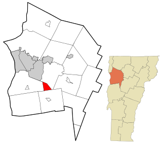
Bolton is a town in Chittenden County, Vermont, United States. The population was 1,182 at the time of the 2010 census, up from 971 in 2000. The town is home to Bolton Valley, a popular ski resort.

Charlotte, Vermont Town in Vermont, United States

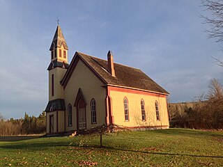
Charlotte is a town in Chittenden County, Vermont, United States. The town was named for Sofia Charlotte of Mecklenburg-Strelitz, Queen of Great Britain and wife of King George III. The population of the town was 3,754 at the 2010 census.

Colchester, Vermont Town in Vermont, United States

Colchester is a town in Chittenden County, Vermont, United States. As of the 2010 census, the population of Colchester was 17,524. It is the fourth-most populous municipality and second-most populous town in the state of Vermont. Colchester borders Burlington, Vermont's most populous municipality. The town is directly to Burlington's north on the eastern shore of Lake Champlain, to the west of the Green Mountains. The Vermont National Guard is based in the town, and it is also home to Saint Michael's College and the Vermont campus of Southern New Hampshire University.

Hinesburg, Vermont Town in Vermont, United States

Hinesburg is a town in Chittenden County, Vermont, United States. The town was named for Abel Hine, town clerk. The population was 4,396 at the 2010 census.

Huntington, Vermont Town in Vermont, United States

Huntington is a town in Chittenden County, Vermont, United States. The population was 1,938 at the 2010 census.

Richmond, Vermont Town in Vermont, United States

Richmond is a town in Chittenden County, Vermont, United States. As of the 2010 census the population was 4,081. The main settlement of Richmond, in the north-central part of town, is a census-designated place (CDP), with a population of 723 at the 2010 census; it was formerly an incorporated village.

St. George, Vermont Town in Vermont, United States

St. George is a town in Chittenden County, Vermont, United States. The town was named for the patron saint of England. St. George has the smallest land area of any town in Vermont, though the incorporated cities of Vergennes and Winooski are smaller. The population was 674 at the 2010 census.

Westford, Vermont Town in Vermont, United States

Westford is a town in Chittenden County, Vermont, United States. The population was 2,029 at the 2010 census.

Chittenden, Vermont Town in Vermont, United States

Chittenden is a town in Rutland County, Vermont, United States. The population was 1,258 at the 2010 census.

Arlington, Vermont Town in Vermont, United States

Arlington is a town in Bennington County, Vermont, United States. The population was 2,317 at the 2010 census.

Jericho (village), Vermont Village in Vermont, United States

Jericho is a village in Chittenden County, Vermont, United States. The population was 1,329 at the 2010 census.

Jericho, Vermont Town in Vermont, United States

Jericho is a town in Chittenden County, Vermont. As of the 2020 census, the population was 5,104. The town was named after the ancient city of Jericho.

Milton (CDP), Vermont Census-designated place in Vermont, United States

Milton is an unincorporated village within the town of Milton in Chittenden County, Vermont, United States. The village disincorporated in 2003 and became a census-designated place (CDP) in 2008. As of the 2010 census the population was 1,861, out of a population of 10,352 for the entire town.

Burlington, Vermont metropolitan area

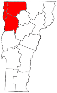
The Burlington metropolitan area is a metropolitan area consisting of the three Vermont counties of Chittenden, Franklin, and Grand Isle. The metro area is anchored by the principal cities of Burlington, South Burlington, St. Albans and Winooski; the towns of Colchester, Essex and Milton; and the village of Essex Junction. According to 2012 U.S. Census estimates, the metro area had an estimated population of 213,701, approximately one third of Vermont's total population.

References

  1. "Census - Geography Profile: Buels gore, Chittenden County, Vermont". United States Census Bureau . Retrieved December 25, 2021.
  2. "Geographic Identifiers: 2010 Demographic Profile Data (G001): Buels gore, Chittenden County, Vermont". U.S. Census Bureau, American Factfinder. Retrieved August 19, 2015.[ dead link ]
  3. "U.S. Census website". United States Census Bureau . Retrieved 2008-01-31.

Coordinates: 44°12′30″N72°57′00″W / 44.20833°N 72.95000°W / 44.20833; -72.95000