Buffalo City, Wisconsin

Last updated

Buffalo City, Wisconsin
1914 City Hall building, Buffalo City, WI.jpg
1914 city hall building
Buffalo County Wisconsin Incorporated and Unincorporated areas Buffalo City Highlighted.svg
Location of Buffalo City in Buffalo County, Wisconsin.
Coordinates: 44°13′59″N91°51′44″W / 44.23306°N 91.86222°W / 44.23306; -91.86222
Country Flag of the United States.svg  United States
State Flag of Wisconsin.svg  Wisconsin
County Buffalo
Chartered1859
Area
[1]
  Total4.00 sq mi (10.35 km2)
  Land1.64 sq mi (4.26 km2)
  Water2.35 sq mi (6.09 km2)
Elevation
[2]
669 ft (204 m)
Population
 (2010) [3]
  Total1,023
  Estimate 
(2019) [4]
954
  Density580.29/sq mi (224.11/km2)
Time zone UTC-6 (Central (CST))
  Summer (DST) UTC-5 (CDT)
FIPS code 55-11062 [5]
GNIS feature ID1562364 [2]
Website Buffalo City

Buffalo City is a city in Buffalo County in the U.S. state of Wisconsin. The population was 1,023 at the 2010 census.

Contents

History

The name may be derived from a buffalo animal husbandry operation in the past. The city was chartered in 1859. [6] At that time it was the only city in Buffalo County.

The town may have been named for three brothers who raised buffalo on a bluff overlooking the city. [6]

Geography

Buffalo City is located at 44°13′59″N91°51′44″W / 44.23306°N 91.86222°W / 44.23306; -91.86222 (44.233180, -91.862219). [7]

According to the United States Census Bureau, the city has a total area of 6.04 square miles (15.64 km2), of which, 2.11 square miles (5.46 km2) is land and 3.93 square miles (10.18 km2) is water. [8]

It is located west of Cochrane, Wisconsin on the shore of Spring Lake, a backwater of the Mississippi River.

Demographics

Historical population
CensusPop.Note
1860 184
1870 26845.7%
1880 248−7.5%
1890 223−10.1%
1900 25413.9%
1910 2550.4%
1920 28612.2%
1930 261−8.7%
1940 29312.3%
1950 3198.9%
1960 48451.7%
1970 67138.6%
1980 89433.2%
1990 9152.3%
2000 1,04013.7%
2010 1,023−1.6%
2019 (est.)954 [4] −6.7%
U.S. Decennial Census [9]

2010 census

As of the census [3] of 2010, there were 1,023 people, 464 households, and 312 families living in the city. The population density was 484.8 inhabitants per square mile (187.2/km2). There were 577 housing units at an average density of 273.5 per square mile (105.6/km2). The racial makeup of the city was 98.4% White, 0.1% African American, 0.2% Native American, 0.3% Asian, and 1.0% from two or more races. Hispanic or Latino of any race were 0.4% of the population.

There were 464 households, of which 22.4% had children under the age of 18 living with them, 57.8% were married couples living together, 6.0% had a female householder with no husband present, 3.4% had a male householder with no wife present, and 32.8% were non-families. 25.4% of all households were made up of individuals, and 12.1% had someone living alone who was 65 years of age or older. The average household size was 2.20 and the average family size was 2.60.

The median age in the city was 49.3 years. 17.3% of residents were under the age of 18; 5.9% were between the ages of 18 and 24; 21.7% were from 25 to 44; 32.5% were from 45 to 64; and 22.7% were 65 years of age or older. The gender makeup of the city was 49.8% male and 50.2% female.

2000 census

As of the census [5] of 2000, there were 1,040 people, 445 households, and 320 families living in the city. The population density was 486.2 people per square mile (187.6/km2). There were 492 housing units at an average density of 230.0 per square mile (88.8/km2). The racial makeup of the city was 98.56% White, 0.19% African American, 0.48% Asian, 0.10% Pacific Islander, and 0.67% from two or more races. Hispanic or Latino of any race were 0.58% of the population.

There were 445 households, out of which 29.0% had children under the age of 18 living with them, 63.1% were married couples living together, 6.1% had a female householder with no husband present, and 27.9% were non-families. 24.7% of all households were made up of individuals, and 11.9% had someone living alone who was 65 years of age or older. The average household size was 2.34 and the average family size was 2.77.

In the city, the population was spread out, with 22.5% under the age of 18, 5.7% from 18 to 24, 26.9% from 25 to 44, 27.2% from 45 to 64, and 17.7% who were 65 years of age or older. The median age was 43 years. For every 100 females, there were 101.6 males. For every 100 females age 18 and over, there were 96.1 males.

The median income for a household in the city was $39,318, and the median income for a family was $48,906. Males had a median income of $30,250 versus $20,625 for females. The per capita income for the city was $18,392. About 1.9% of families and 3.8% of the population were below the poverty line, including 5.7% of those under age 18 and 4.8% of those age 65 or over.

Education

Buffalo City is part of the Cochrane-Fountain City School District.

Landmarks

Buffalo City is home to the original Buffalo County Jail, which was built in 1862 and is now part of the city's park between 10th and 12th streets. Another unusual feature of the city is a large Viking statue, located at the corner of River Road and W 17th Street. [10]

Related Research Articles

<span class="mw-page-title-main">Pelican Bay, Florida</span> Census-designated place in Florida

Pelican Bay is a census-designated place (CDP) in Collier County, Florida, United States. The population was 6,346 at the 2010 census. It is part of the Naples–Marco Island Metropolitan Statistical Area.

<span class="mw-page-title-main">Pine Ridge, Collier County, Florida</span> Census-designated place in Florida

Pine Ridge is a census-designated place (CDP) in Collier County, Florida, United States. The population was 1,918 at the 2010 census. It is part of the Naples–Marco Island Metropolitan Statistical Area.

<span class="mw-page-title-main">Toulon, Illinois</span> City in Illinois, United States

Toulon is a city in Stark County, Illinois, United States. The population was 1,292 at the 2010 census. It is the county seat of Stark County. Toulon is part of the Peoria, Illinois Metropolitan Statistical Area, and is the northwestern terminus of the Rock Island Trail State Park.

<span class="mw-page-title-main">Bright, Indiana</span> Census-designated place in Indiana, United States

Bright is an unincorporated community and census-designated place (CDP) in Dearborn County, Indiana, United States. The population was 5,814 at the 2020 census.

<span class="mw-page-title-main">Randalia, Iowa</span> City in Iowa, United States

Randalia is a city in Fayette County, Iowa, United States. The population was 51 at the time of the 2020 census.

<span class="mw-page-title-main">Sloan, Iowa</span> City in Iowa, United States

Sloan is a city in Woodbury County, Iowa, United States. It is part of the Sioux City, IA–NE–SD Metropolitan Statistical Area. The population was 1,042 at the time of the 2020 census.

<span class="mw-page-title-main">Spicer, Minnesota</span> City in Minnesota, United States

Spicer is a city in Kandiyohi County, Minnesota, United States situated on Green Lake. The population was 1,167 at the 2010 census. Sibley State Park and many surrounding lakes are nearby.

<span class="mw-page-title-main">Crugers, New York</span> Hamlet and census-designated place in Cortlandt, New York

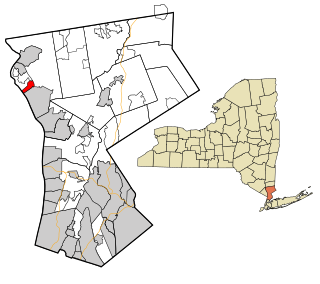
Crugers is a hamlet and census-designated place (CDP) located in the town of Cortlandt, Westchester County, New York, United States. The population was 1,534 at the 2010 census.

Jaars, capitalized as JAARS on some maps, is a census-designated place (CDP) in Union County, North Carolina, United States. The population was 597 at the 2010 census. The region's name comes from JAARS, a non-profit organization that is located there.

<span class="mw-page-title-main">Flasher, North Dakota</span> City in North Dakota, United States

Flasher is a city in Morton County, North Dakota, United States. It is part of the "Bismarck, ND Metropolitan Statistical Area" or "Bismarck-Mandan". The population was 217 at the 2020 census. Flasher was founded in 1902.

<span class="mw-page-title-main">Forward Township, Allegheny County, Pennsylvania</span> Township of Allegheny County, Pennsylvania

Forward Township is a township in Allegheny County, Pennsylvania, United States. The population was 3,068 at the 2020 census. The township is named after Walter Forward, U.S. Secretary of the Treasury from 1841 to 1843.

<span class="mw-page-title-main">Hopewell Township, Huntingdon County, Pennsylvania</span> Township in Pennsylvania, United States

Hopewell Township is a township in Huntingdon County, Pennsylvania, United States. The population was 458 at the 2020 census.

<span class="mw-page-title-main">West Lampeter Township, Lancaster County, Pennsylvania</span> Township in Pennsylvania, United States

West Lampeter Township is a township in central Lancaster County, Pennsylvania, United States. The population was 17,365 at the 2020 census.

<span class="mw-page-title-main">Ceres Township, McKean County, Pennsylvania</span> Township in Pennsylvania, United States

Ceres Township is a township in McKean County, Pennsylvania, United States. The population was 836 at the 2020 census.

<span class="mw-page-title-main">Fairview Township, Mercer County, Pennsylvania</span> Township in Pennsylvania, United States

Fairview Township is a township in Mercer County, Pennsylvania, United States. The population was 950 at the 2020 census, a decline from the figure of 1,085 in 2010.

<span class="mw-page-title-main">Morris Township, Tioga County, Pennsylvania</span> Township in Pennsylvania, United States

Morris Township is a township in Tioga County, Pennsylvania, United States. The population was 562 at the 2020 census.

<span class="mw-page-title-main">Nelson Township, Tioga County, Pennsylvania</span> Township in Pennsylvania, United States

Nelson Township is a township in Tioga County, Pennsylvania, United States. The population was 545 at the 2020 census.

<span class="mw-page-title-main">Farmington Township, Warren County, Pennsylvania</span> Township in Pennsylvania, United States

Farmington Township is a township in Warren County, Pennsylvania, United States. The population was 1,288 at the 2020 census, up from 1,259 in 2010.

<span class="mw-page-title-main">City View, South Carolina</span> Census-designated place in South Carolina, United States

City View, a former incorporated city, is now a census-designated place (CDP) in Greenville County, South Carolina, United States. The population was 1,345 at the 2010 census, up from 1,254 in 2000. It is part of the Greenville–Mauldin–Easley Metropolitan Statistical Area.

Effie is an unorganized territory in Itasca County, Minnesota, United States. The population was 203 at the 2010 census.

References

  1. "2019 U.S. Gazetteer Files". United States Census Bureau. Retrieved August 7, 2020.
  2. 1 2 "US Board on Geographic Names". United States Geological Survey. October 25, 2007. Retrieved January 31, 2008.
  3. 1 2 "U.S. Census website". United States Census Bureau . Retrieved November 18, 2012.
  4. 1 2 "Population and Housing Unit Estimates". United States Census Bureau. May 24, 2020. Retrieved May 27, 2020.
  5. 1 2 "U.S. Census website". United States Census Bureau . Retrieved January 31, 2008.
  6. 1 2 "About Buffalo City". Town of Buffalo City, Wisconsin. Retrieved July 21, 2012.
  7. "US Gazetteer files: 2010, 2000, and 1990". United States Census Bureau. February 12, 2011. Retrieved April 23, 2011.
  8. "US Gazetteer files 2010". United States Census Bureau. Archived from the original on January 25, 2012. Retrieved November 18, 2012.
  9. "Census of Population and Housing". Census.gov. Retrieved June 4, 2015.
  10. "Buffalo City, WI - Viking Statue". Roadside America. Retrieved October 26, 2012.