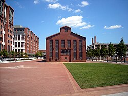
The Washington Navy Yard (WNY) is the former shipyard and ordnance plant of the United States Navy in Southeast Washington, D.C. It is the oldest shore establishment of the U.S. Navy.
Capitol Hill, in addition to being a metonym for the United States Congress, is the largest historic residential neighborhood in Washington, D.C., stretching easterly in front of the United States Capitol along wide avenues. It is one of the oldest residential neighborhoods in Washington, D.C., and, with roughly 35,000 people in just under 2 square miles (5 km2), it is also one of the most densely populated.

The Green Line is a rapid transit line of the Washington Metro system, consisting of 21 stations in the District of Columbia and Prince George's County, Maryland, United States. The Green Line runs from Branch Avenue to Greenbelt. It was the last line in the original Metrorail plan to be constructed, and is one of three north–south lines through the city of Washington. The Green Line shares tracks with the Yellow line from L'Enfant Plaza to Greenbelt.

Anacostia is a historic neighborhood in Washington, D.C. Its downtown is located at the intersection of Good Hope Road and Martin Luther King Jr. Avenue. It is located east of the Anacostia River, after which the neighborhood is named. Like the other quadrants of Washington, D.C., Southeast encompasses many named neighborhoods, of which Anacostia is the most well known. Anacostia includes all of the Anacostia Historic District that was listed on the National Register of Historic Places in 1978. Often the name Anacostia is incorrectly used to refer to the entire portion of the city that is southeast of the Anacostia River. The Anacostia Business Improvement District is responsible for the development of the area.

Anacostia is a Washington Metro station in Washington, D.C. on the Green Line. The station is located in the Anacostia neighborhood of Southeast Washington, with entrances at Shannon Place and Howard Road near Martin Luther King, Jr. Avenue SE. The station serves as a hub for Metrobus routes in Southeast, Washington, D.C. and Prince George's County, Maryland.

Streetcars in Washington, D.C. transported people across the city and region from 1862 until 1962.
South Capitol Street is a major street dividing the southeast and southwest quadrants of Washington, D.C., in the United States. It runs south from the United States Capitol to the D.C.–Maryland line, intersecting with Southern Avenue. After it enters Maryland, the street becomes Indian Head Highway at the Eastover Shopping Center, a terminal or transfer point of many bus routes.
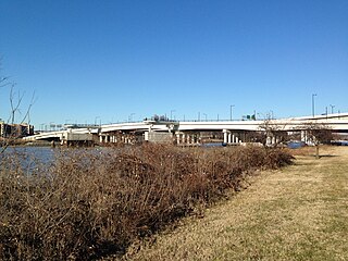
The 11th Street Bridges are a complex of three bridges across the Anacostia River in Washington, D.C., United States. The bridges convey Interstate 695 across the Anacostia to its southern terminus at Interstate 295 and DC 295. The bridges also connect the neighborhood of Anacostia with the rest of the city of Washington.

The DC Circulator is a bus system in Washington, D.C. The District of Columbia Department of Transportation operates the service in a public–private partnership with RATP Dev.

Barney Circle is a small residential neighborhood located between the west bank of the Anacostia River and the eastern edge of Capitol Hill in southeast Washington, D.C., in the United States. The neighborhood is characterized by its sense of community, activism, walkability, and historic feel. The neighborhood's name derives from the eponymous former traffic circle Pennsylvania Avenue SE just before it crosses the John Philip Sousa Bridge over the Anacostia. The traffic circle is named for Commodore Joshua Barney, Commander of the Chesapeake Bay Flotilla in the War of 1812.

The National Capital Planning Commission (NCPC) is a U.S. government executive branch agency that provides planning guidance for Washington, D.C., and the surrounding National Capital Region. Through its planning policies and review of development proposals, the Commission seeks to protect and enhance the extraordinary resources of the national capital.

Fairlawn is a working class and middle class residential neighborhood in southeast Washington, D.C., United States. It is bounded by Interstate 295, Pennsylvania Avenue SE, Minnesota Avenue SE, Naylor Road SE, and Good Hope Road SE.

Navy Yard, also known as Near Southeast, is a neighborhood on the Anacostia River in Southeast Washington, D.C. Navy Yard is bounded by Interstate 695 to the north and east, South Capitol Street to the west, and the Anacostia River to the south. Approximately half of its area is occupied by the Washington Navy Yard, which gives the neighborhood its name. The neighborhood is located in D.C.'s Ward 6, currently represented by Charles Allen. It is served by the Navy Yard – Ballpark Metro station on the Green Line.
The Anacostia and Potomac River Railroad Company was the fourth streetcar company to operate in Washington, D.C., and the first to cross the Anacostia River. It was chartered in 1870, authorized by Congress in 1875 and built later that year. The line ran from the Arsenal to Union Town. It expanded, adding lines to Congressional Cemetery, Central Market and to the Government Hospital for the Insane; and in the late 1890s it purchased two other companies and expanded their lines. It was reluctant to change its operations, but in 1900 it relented to pressure and became the last company to switch from horse cars to electric streetcars. It was one of the few companies not to be swept up by the two major streetcar companies at the turn of the 20th century, but it could not hold out forever and on August 31, 1912, it was purchased by the Washington Railway and Electric Company and ceased to operate as a unique entity.

The DC Streetcar is a surface streetcar network in Washington, D.C. As of 2017, it consists of only one line: a 2.2-mile (3.5 km) segment running in mixed traffic along H Street and Benning Road in the city's Northeast quadrant.
The Capitol Riverfront is a business improvement district (BID) located just south of the United States Capitol between Capitol Hill and the Anacostia River in Washington, D.C. It was created by the District of Columbia City Council and approved by Mayor Fenty in August 2007. The BID is a mixed-use neighborhood. It was a former industrial area transformed into a business center, urban neighborhood, entertainment district, and waterfront destination. The project involves adding over 9,000 new apartments, condominiums, lofts, modern office towers, 1,200 hotel rooms, one million square feet of retail amenities, two grocery stores, new restaurants, shops, and cafes. Over 33,900,000 square feet of office, residential, hotel, and retail space, as well as four new parks, were planned over 10–15 years. The new 5-acre (20,000 m2) riverfront Yards Park opened in fall 2010.

Buzzard Point is an urbanized area located on the peninsula formed by the confluence of the Potomac and Anacostia Rivers in the southwest quadrant of Washington, D.C., United States.

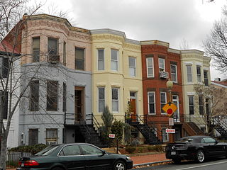
The Anacostia Historic District is a historic district in the city of Washington, D.C., comprising approximately 20 squares and about 550 buildings built between 1854 and 1930. The Anacostia Historic District was added to the National Register of Historic Places in 1978. "The architectural character of the Anacostia area is unique in Washington. Nowhere else in the District of Columbia does there exist such a collection of late-19th and early-20th century small-scale frame and brick working-class housing."

The Yards is a 42-acre (17 ha) development on the Anacostia River waterfront in Washington, D.C. The area is at the center of the Capitol Riverfront Business Improvement District and was originally an annex of the Washington Navy Yard. In 2004, the U.S. General Services Administration awarded the property to Forest City Washington, Inc. for redevelopment into an area with 2,800 new residential units and 2,200,000 sq ft (200,000 m2) of office and retail space.. The development is just west of the Washington Navy Yard and east of Nationals Park. It is served by the Navy Yard – Ballpark station on the Green Line of the Washington Metro.

The Anacostia Line is a partially constructed line of the DC Streetcar, never put into service, intended to connect the Anacostia neighborhood with Joint Base Anacostia–Bolling. Construction occurred in 2009 and 2010, but was terminated before the line was complete.