Related Research Articles

Multnomah County is one of the 36 counties in the U.S. state of Oregon. As of the 2020 census, the county's population was 815,428. Multnomah County is part of the Portland–Vancouver–Hillsboro, OR–WA metropolitan statistical area. Though smallest in area, Multnomah County is the state's most populous county. Its county seat, Portland, is the state's largest city.
Portland Community College (PCC) is a public community college in Portland, Oregon. It is the largest post-secondary institution in the state and serves residents in the five-county area of Multnomah, Washington, Yamhill, Clackamas, and Columbia counties. As of the 2021–2022 academic year, PCC enrolls more than 50,000 full-time (40%) and part-time (60%) students.

The Portland metropolitan area is a metro area in the U.S. states of Oregon and Washington centered on the principal city of Portland, Oregon. The U.S. Office of Management and Budget (OMB) identifies it as the Portland–Vancouver–Hillsboro, OR–WA Metropolitan Statistical Area, a metropolitan statistical area used by the United States Census Bureau (USCB) and other entities. The OMB defines the area as comprising Clackamas, Columbia, Multnomah, Washington, and Yamhill Counties in Oregon, and Clark and Skamania Counties in Washington. The area had a population of 2,512,859 at the 2020 census, an increase of over 12% since 2010.

Shepperd's Dell is a small canyon in the Columbia River Gorge in Oregon, located at 45.54833°N 122.195°W which is less than one-third mile southeast of Rooster Rock State Park. The Shepperd's Dell Bridge is listed on the National Register of Historic Places.

Government Island is a 1,760-acre (710 ha) island in the Columbia River north of Portland, in Multnomah County, in the U.S. state of Oregon. Though Interstate 205 passes over it on the Glenn L. Jackson Memorial Bridge, access to the island is only by boat. There is a city controlled locked gate in the fence surrounding the freeway.
Multnomah Education Service District (MESD) is an education service district that coordinates school events and activities throughout the school districts in Multnomah County, Oregon, United States. Its administrative offices are located at 11611 NE Ainsworth Circle in Portland.
Sylvan-Highlands is a neighborhood of Portland, Oregon, United States located on the west side of the West Hills.
Hayhurst is a neighborhood in the southwest section of Portland, Oregon, on the border with Washington County. It borders Raleigh Hills and Beaverton, and the Portland neighborhoods of Bridlemile, Hillsdale, and Maplewood and Multnomah.

Oregon's 3rd congressional district covers most of Multnomah County, including Gresham, Troutdale, and most of Portland east of the Willamette River. It also includes the northeastern part of Clackamas County and all of Hood River County. Generally, most of Portland east of the Willamette River is in the 3rd District.
Centennial School District 28J is a school district in the U.S. state of Oregon, with an enrollment of approximately 6,700 students. Its headquarters are in Gresham, with a Portland postal address.

Coopey Falls is a waterfall on Coopey Creek in the Columbia River Gorge, on the Historic Columbia River Highway in Multnomah County, Oregon. The falls is a horsetail waterfall with a drop of 150 feet (46 m).

Blue Lake Regional Park is a public park in Fairview, in the U.S. state of Oregon. The 101-acre (41 ha) park, near the south shore of the Columbia River in Multnomah County, includes many covered and uncovered picnic areas, playing fields for sports such as softball, a cross country course and infrastructure related to lake recreation including swimming, boating, and fishing. Encompassing wooded areas, three ponds, and a wetland in addition to the lake, the park is frequented by migrating birds and other wildlife. Paved paths run through the park, which is near the 40-Mile Loop hiking and biking trail. Park vegetation includes cottonwoods, willows, and other trees and shrubs as well as wetland plants such as cattails.
Tonquin is an unincorporated locale in Washington County, Oregon, United States.
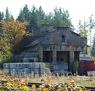
Holbrook is an unincorporated community in Multnomah County, Oregon, United States. It is located on U.S. Route 30 about 15 miles northwest of Portland between the Tualatin Mountains and the Multnomah Channel south of Sauvie Island. Holbrook's elevation is 135 feet above sea level.
Dodson is an unincorporated community in Multnomah County, Oregon, United States. It is located about 4½ miles (7.2 km) east of Multnomah Falls and one mile west of Warrendale, in the Columbia River Gorge on Interstate 84/U.S. Route 30. It is across the Columbia River from Skamania, Washington. Dodson is within the Cascade Locks ZIP code.

Warrendale is an unincorporated community in Multnomah County, Oregon, United States. It is located about a mile east of Dodson and about 3 miles (4.8 km) west of Bonneville in the Columbia River Gorge on Interstate 84/U.S. Route 30. It is across the Columbia River from Beacon Rock. The community was the site of an important salmon cannery founded in the 1870s.

Prism Health is a health clinic located on Southeast Belmont Street, in Portland, Oregon's Buckman neighborhood, in the United States. Prism became Oregon's first LGBT primary health clinic in 2017, and opened as an extension of the Cascade AIDS Project.
References
- ↑ U.S. Geological Survey Geographic Names Information System: Burlington, Multnomah County, Oregon
- ↑ Oregon Atlas & Gazetteer (7th ed.). Yarmouth, Maine: DeLorme. 2008. p. 22. ISBN 0-89933-347-8.
- ↑ ""Burlington, Oregon"". columbiariverimages.com. Archived from the original on September 10, 2015. Retrieved November 3, 2015.
- ↑ Charter and General Ordinances of the City of Portland, Oregon: In Force April 15, 1910. 1910. p. 396.
Municipalities and communities of Multnomah County, Oregon, United States | ||
|---|---|---|
| Cities | 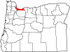 | |
| CDPs | ||
| Other communities | ||
| Footnotes | ‡This populated place also has portions in an adjacent county or counties | |
45°38′46″N122°50′33″W / 45.64611°N 122.84250°W
| | This Multnomah County, Oregon state location article is a stub. You can help Wikipedia by expanding it. |