Butaritari

Last updated
Butaritari
02 Map of Butaritari, Kiribati.jpg
Map of Butaritari
GilbertIslandsPos.png
Kiribati location map.svg
Red pog.svg
Butaritari
Micronesia regions map.png
Red pog.svg
Butaritari
Oceania laea location map.svg
Red pog.svg
Butaritari
Pacific Ocean laea location map.svg
Red pog.svg
Butaritari
Geography
Location Pacific Ocean
Coordinates 3°10′04″N172°49′33″E / 3.16778°N 172.82583°E / 3.16778; 172.82583 (Butaritari)
Archipelago Gilbert Islands
Area13.49 km2 (5.21 sq mi)
Highest elevation3 m (10 ft)
Administration
Largest villageTaubukinmeang
Demographics
Population3,224 (2015 Census)
Pop. density322/km2 (834/sq mi)
Ethnic groups I-Kiribati 90.6%

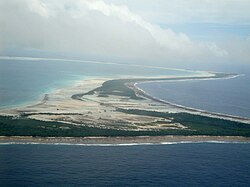
Butaritari is an atoll in the Pacific Ocean island nation of Kiribati. The atoll is roughly four-sided. The south and southeast portion of the atoll comprises a nearly continuous islet. The atoll reef is continuous but almost without islets along the north side. Bikati and Bikatieta islets occupy a corner of the reef at the extreme northwest tip of the atoll. Small islets are found on reef sections between channels on the west side. The lagoon of Butaritari is deep and can accommodate large ships, though the entrance passages are relatively narrow. It is the most fertile of the Gilbert Islands, with relatively good soils (for an atoll) and high rainfall. Butaritari atoll has a land area of 13.49 km2 (5.21 sq mi) and a population of 3,224 as of 2015. During World War II, Butaritari was known by United States Armed Forces as Makin Atoll, and was the site of the Battle of Makin. Locally, Makin is the name of a separate but closest atoll, 3 kilometres (1.6 nmi; 1.9 mi) to the northeast of Butaritari, but close enough to be seen. These two atolls share a dialect of the Gilbertese language.

Contents

Geography

The causeway connecting Tanimaiaki and Keuea Butaritari-causeway.jpg
The causeway connecting Tanimaiaki and Keuea

Butaritari is the second most northerly of the Gilbert Islands; 3 kilometres (1.6 nmi; 1.9 mi) to the northeast is Makin. Butaritari was called Makin Atoll by the U.S. military, and present-day Makin was then known as Makin Meang (Northern Makin) or Little Makin to distinguish it. Now that Butaritari has become the preferred name for the larger atoll, speakers tend to drop the qualifier for Makin. Butaritari has also previously been known as Pitt Island, Taritari Island, or Touching Island.

The atoll is roughly four-sided and nearly 30 km (19 mi) across in the east–west direction, and averages about 15 km (9 mi) north to south. The reef is more submerged and broken into several broad channels along the west side. Small islets are found on reef sections between these channels. The atoll reef is continuous but almost without islets along the north side. In the northeast corner, the reef is some 1.75 km (1.09 mi) across and with only scattered small islet development. Thus, the lagoon of Butaritari is very open to exchange with the ocean. The lagoon is deep and can accommodate large ships, though the entrance passages are relatively narrow. [1]

The south and southeast portion of the atoll comprises a nearly continuous islet, broken only by a single, broad section of interislet reef. These islets are mostly between 0.2 km (0.1 mi) and 0.5 km (0.3 mi) across, but widen in the areas where the reef changes directions. Mangrove swamps appear well developed in these latter areas as well as all along the southern lagoon shore. (Narrow islets are somewhat characteristic of Kiribati atolls running east–west.) [1]

Bikati and Bikatieta islets occupy a corner of the reef at the extreme northwest tip of the atoll, bordering a small lagoon to the north of the main lagoon. There is a village on the larger Bikati (2 by 0.5 km). [1]

Environmental issues

Seepage of saltwater into the pits in which babai ( Cyrtosperma merkusii or giant swamp taro) is grown is the major concern of islanders. [2] The erosion problems are identified as being linked to aggregate mining, land reclamation and the construction of causeways that is thought to change the currents along the shoreline. [2] The causeways have also resulted to reduced flushing of the lagoon that has resulted in low levels of oxygen, therefore causing damage to fish stocks in the lagoon and causes other biological problems. [2] Aggregate mining and the removal of coral boulders is exacerbating coastal erosion. [2]

Villages

Butaritari Atoll and part of Makin (upper right). Most of Makin is missing from this map and only a portion is visible. Butaritari Map.jpg
Butaritari Atoll and part of Makin (upper right). Most of Makin is missing from this map and only a portion is visible.

The population of Butaritari in the 2010 Census [3] was 4,346 people, inhabiting twelve villages:

Kuuma323 inhabitants
Ukiangang707 inhabitants
Bikaati225 inhabitants
Tikurere8 inhabitants
Keuea258 inhabitants
Tanimainiku248 inhabitants
Tanimaiaki267 inhabitants
Tabonuea271 inhabitants
Antekana217 inhabitants
Taubukinmeang835 inhabitants
Temanokunuea621 inhabitants
Onomaru366 inhabitants

Climate

Butaritari is one of the lushest of the islands of Kiribati due to good rainfall. Typical annual rainfall is about 4 m, compared with about 2 m on Tarawa Atoll and 1 m in the far south of Kiribati. Rainfall on Butaritari is enhanced during an El Niño.

Economy

Butaritari has rich marine resources, with a large lagoon and wide reef. Butaritari has the greatest potential for agriculture in Kiribati: bananas, breadfruit and papaya grow well, and successful cultivars of pumpkin, cabbage, cucumber, eggplant and other vegetables have been created with assistance from the Taiwan Technical Mission based in South Tarawa. However, most households keep to a subsistence lifestyle and, although food is plentiful, money is often scarce as there are few paid jobs on the island. [4]

History

Early history

Portrait of a native of the Makin islands, drawn by Alfred Thomas Agate (1841) Makin Islander.jpg
Portrait of a native of the Makin islands, drawn by Alfred Thomas Agate (1841)

Myths and legends

There are different stories told as to the creation of Butaritari and the other islands in the Southern Gilberts. An important legend in the culture of Butaritari is that spirits who lived in a tree in Samoa migrated northward carrying branches from the tree, Te Kaintikuaba, which translates as the tree of life. [2] It was these spirits, together with Nareau the Wise who created the islands of Tungaru (the Gilbert Islands). [Note 1]

1606 to 1899

The Spanish expedition led by Pedro Fernandes de Queirós sighted the Buen Viaje (good trip in Spanish) Islands (Butaritari and Makin) on 8 July 1606. [7] [8]

Traditionally, Butaritari and Makin were ruled by a chief or Uea who lived on Butaritari Island. [2] This chief had all the powers and authority to make and impose decisions for Butaritari and Makin, a system very different from the southern Gilbert Islands where power was wielded collectively by the unimwane or old men.

The people of Kuma village had the power to call dolphins or whales, and used this ability on special occasions to provide meat for important feasts such as the opening of a new maneaba. [9]

The islands were visited as part of the United States Exploring Expedition in 1841. [10] Any possible Guano Islands Act claim by the United States to Butaritari and Little Makin was renounced in the 1970s.

The first traders resident in the Gilberts were Randell and Durant who arrived in 1846. Durant moved on to Makin, while Randell remained on Butaritari. [2] The earliest trading companies on Butaritari were the Hamburg-based Handels-und Plantagen-Gesellschaft der Südsee-Inseln zu Hamburg (DHPG) with Pacific headquarters in Samoa, and On Chong (Chinese traders with Australian connections via the goldfields). These traders helped Butaritari became the commercial and trading capital of the Gilbert Islands until Burns Philp, a powerful trading company, moved to Tarawa, following the seat of political power.

Robert Louis Stevenson, Fanny Vandegrift Stevenson and Lloyd Osbourne visited Butaritari from 14 July 1889 to early August. [11] At this time Nakaeia was the ruler of Butaritari and Makin atolls, his father being Tebureimoa and his grandfather being Tetimararoa. Nakaeia was described by Stevenson as “a fellow of huge physical strength, masterful, violent … Alone in his islands it was he who dealt and profited; he was the planter and the merchant” with his subjects toiling in servitude and fear. [12]

Nakaeia allowed two San Francisco trading firms to operate, Messrs. Crawford and Messrs. Wightman Brothers, with up to 12 Europeans resident on islands of the atolls. The presence of the Europeans, and the alcohol they traded to the islanders, resulted in periodic alcoholic binges that only ended with Nakaeia making tapu (forbidding) the sale of alcohol. During the 15 or so days that Stevenson spent on Butaritari the islanders were engaged in a drunken spree that threatened the safety of Stevenson and his family. Stevenson adopted the strategy of describing himself as the son of Queen Victoria so as to ensure that he would be treated as a person who should not be threatened or harmed. [12]

The last Uea was Nauraura Nakoriri who was in power both before and after the Gilberts became a British Protectorate in 1892. [2]

1900 to 1941

Butaritari Post Office opened on 1 January 1911. [13]

The Japanese trading company Nanyo Boeki Kabushiki Kaisha established operations in Butaritari Village. W. R. Carpenter & Co. (Solomon Islands) Ltd was established in 1922. [14] [15] [16] Through the 1920s On Chong experienced gradual decline in its operations as the result of low copra prices. Eventually On Chong was taken over by W. R. Carpenter & Co.

World War II

A war monument in Ukiangang village, Butaritari Ukiangang-warmonument.jpg
A war monument in Ukiangang village, Butaritari

Japanese invasion

On 10 December 1941, three days after the attack on Pearl Harbor, 300 Japanese troops, plus laborers of the "Gilberts Invasion Special Landing Force" arrived off Butaritari — then known as "Makin" — and occupied without resistance. Lying east of the Marshall Islands, Makin would make an excellent seaplane base, extending Japanese air patrols closer to Howland Island, Baker Island, Tuvalu, Phoenix and Ellice Islands, all held by the Allies and protecting the eastern flank of the Japanese perimeter from an Allied attack.

American raid

Butaritari atoll was the site of the Makin Raid in August 1942, when two companies of the 2nd Marine Raider Battalion landed from the submarines USS Argonaut and USS Nautilus, as a feint to draw Japanese attention away from the planned invasion route through the Solomons. While they annihilated the local garrison, they failed in their initial objectives of taking prisoners and gathering intelligence.

American invasion

On the eve of invasion, the Japanese garrison consisted of 806 men. Most were of aviation or Japanese and Korean labor units who had little or no combat training and were not assigned weapons or a battle station. The number of trained combat troops on Makin was no more than 300 soldiers. The garrison included three tanks and three 37 mm (1.5 inch) anti-tank guns.

Butaritari's land defenses were centered around the lagoon shore, near the seaplane base in the central part of the island. A series of strongpoints was established along Butaritari's ocean side as the Japanese expected the invasion to come from there, following the example of a raid in 1942. Without aircraft, ships, or hope of reinforcement or relief, the outnumbered and outgunned defenders could only try to delay the American attack for as long as possible.

American air operations began on November 13, 1943, followed by bombardment from fire support ships. Troops began to go ashore on November 20, and the attacking troops knocked out the fortified strongpoints one by one. Despite their great superiority in men and weapons, the Americans had considerable difficulty subduing the island's small defensive force. On November 23 the force commander reported "Makin taken."

As compared to an estimated 395 Japanese and Koreans killed in action, American combat casualties numbered 66 killed and 152 wounded. But when the American losses incurred during the sinking of the escort carrier USS Liscome Bay on November 24 by a Japanese submarine are included, the loss balance tips toward the other side. Counting the 687 sailors who went down with the carrier, American casualties exceeded the strength of the entire Japanese garrison on Makin.

Visiting Butaritari

Butaritari is served by a twice weekly air service connecting with neighbouring Makin and the capital, South Tarawa, provided by Air Kiribati. The runway of Butaritari Atoll Airport was originally built as the World War II American strip (Starmann Field). An international air service with a route of Tarawa Atoll–Butaritari–Majuro operated for a short period in 1995. The aim was to facilitate the development of a strong cash crop economy on the island and link the Marshall Islands with Kiribati. With the demise of Air Nauru in 2008, the only international air connection is through South Tarawa, which is connected by a twice weekly Fiji Airways flight with Fiji.

There are three guesthouses on Butaritari, providing a basic level of accommodation aimed mainly at government staff and visitors, though tourists are welcomed. [17]

See also

Notes

  1. Sir Arthur Grimble, cadet administrative officer in the Gilberts from 1914 and resident commissioner of the Gilbert and Ellice Islands colony from 1926, recorded the myths and oral traditions of the Kiribati people. He wrote the best-sellers A Pattern of Islands (London, John Murray 1952, [5] and Return to the Islands (1957), which was republished by Eland, London in 2011, ISBN   978-1-906011-45-1. He also wrote Tungaru Traditions: writings on the atoll culture of the Gilbert Islands, University of Hawaii Press, Honolulu, 1989, ISBN   0-8248-1217-4. [6]

Related Research Articles

<span class="mw-page-title-main">History of Kiribati</span> Historical development of Kiribati

The islands which now form the Republic of Kiribati have been inhabited for at least seven hundred years, and possibly much longer. The initial Austronesian peoples’ population, which remains the overwhelming majority today, was visited by Polynesian and Melanesian invaders before the first European sailors visited the islands in the 17th century. For much of the subsequent period, the main island chain, the Gilbert Islands, was ruled as part of the British Empire. The country gained its independence in 1979 and has since been known as Kiribati.

<span class="mw-page-title-main">Gilbert Islands</span> 1976–1979 British colony in the Pacific

The Gilbert Islands are a chain of sixteen atolls and coral islands in the Pacific Ocean, about halfway between Papua New Guinea and Hawaii. They constitute the main part of the nation of Kiribati.

<span class="mw-page-title-main">Gilbert and Ellice Islands</span> 1892–1976 British colony in the Pacific

The Gilbert and Ellice Islands in the Pacific Ocean were part of the British Empire from 1892 to 1976. They were a protectorate from 1892 to 12 January 1916, and then a colony until 1 January 1976, and were administered as part of the British Western Pacific Territories (BWPT) until they became independent. The history of GEIC was mainly characterized by phosphate mining on Ocean Island. In October 1975, these islands were divided by force of law into two separate colonies, and they became independent nations shortly thereafter: the Ellice Islands became Tuvalu in 1978, and the Gilbert Islands became part of Kiribati in 1979.

<span class="mw-page-title-main">Tamana, Kiribati</span> Island of Kiribati

Tamana is the smallest island in the Gilbert Islands. It is accessible both by boat and by air with Air Kiribati and Coral Sun Airways. 1,054 people live in Tamana.

<span class="mw-page-title-main">Abaiang</span> Atoll of Kiribati

Abaiang, also known as Apaiang, Apia, and in the past, Charlotte Island, in the Northern Gilbert Islands, is a coral atoll of Kiribati, located in the west-central Pacific Ocean. Abaiang was the island of the first missionary to arrive in the Gilberts, Hiram Bingham II. Abaiang has a population of 5,872.

<span class="mw-page-title-main">Tarawa</span> Atoll in the South Pacific

Tarawa is an atoll and the capital of the Republic of Kiribati, in the Micronesia region of the central Pacific Ocean. It comprises North Tarawa, which has 6,629 inhabitants and much in common with other more remote islands of the Gilbert group, and South Tarawa, which has 56,388 inhabitants as of 2015, half of the country's total population. The atoll was the site of the Battle of Tarawa during World War II.

<span class="mw-page-title-main">South Tarawa</span> Island of the Republic of Kiribati

South Tarawa is the capital and hub of the Republic of Kiribati and home to more than half of Kiribati's population. The South Tarawa population centre consists of all the small islets from Betio in the west to Bonriki and Tanaea in the north-east, connected by the South Tarawa main road, with a population of 63,439 as of 2020.

<span class="mw-page-title-main">Battle of Makin</span> Battle of the Pacific Theater of World War II

The Battle of Makin was an engagement of the Pacific campaign of World War II, fought from 20 to 24 November 1943 on Makin Atoll in the Gilbert Islands.

<span class="mw-page-title-main">Abemama</span> Atoll of Kiribati

Abemama (Apamama) is an atoll, one of the Gilberts group in Kiribati, and is located 152 kilometres southeast of Tarawa and just north of the Equator. Abemama has an area of 27.37 square kilometres and a population of 3,299 as of 2015. The islets surround a deep lagoon. The eastern part of the atoll of Abemama is linked together by causeways making automobile traffic possible between the different islets. The outlying islands of Abatiku and Biike are situated on the southwestern side of the atoll.

<span class="mw-page-title-main">Beru (atoll)</span>

Beru is an atoll in the Southern Gilbert Islands in the Pacific Ocean, part of the Republic of Kiribati. Beru was previously known as Eliza, Francis Island, Maria, Peroat, Peru Island or Sunday. It's part of a larger reef with the Nuka Lagoon at its center, and the nearest island is Nikunau. The Tabiang Lagoon is present in the north. Beru is home to 2,051 inhabitants. Due to sea surges, the atoll is experiencing coastal erosion along with damages to seawalls.

<span class="mw-page-title-main">Kuria (atoll)</span> Atoll in Central Gilbert Islands, Kiribati

Kuria is an atoll, formed by a pair of islets, in the Central Gilbert Islands in Kiribati, northwest of Aranuka. The two islets, Buariki and Oneeke, are separated by a 20 metre wide channel on a shallow water platform, which is crossed by a bridge of the connecting road. The islands are surrounded by fringing reef which is broadest on the eastern side of Kuria. The population of Kuria was 1,046 in 2015.

<span class="mw-page-title-main">Maiana</span> Atoll in Gilbert Islands, Kiribati

Maiana is an atoll in Kiribati and is one of the Central Gilbert Islands. Maiana is 44 kilometres (27 mi) south of the capital island of South Tarawa and has a population of 1,982 as of 2015. The northern and eastern sides of the atoll are a single island, whilst the western edge consists of submerged reefs and many uninhabited islets, all surrounding a lagoon. The atoll is 14 kilometres (8.7 mi) long and is very narrow, with an average width of less than 1 kilometre (0.62 mi) and a total land area of 16.72 square kilometres (6.46 sq mi).

<span class="mw-page-title-main">Marakei</span>

Marakei is a small atoll in the North Gilbert Islands. It consists of a central lagoon with numerous deep basins, surrounded by two large islands separated by two narrow channels. The atoll covers approximately 40 square kilometres (15 sq mi).

<span class="mw-page-title-main">Nikunau</span>

Nikunau is a low coral atoll in the Gilbert Islands that forms a council district of the Republic of Kiribati. It consists of two parts, with the larger in the northwest, joined by an isthmus about 150 metres (490 ft) wide.

<span class="mw-page-title-main">Onotoa</span>

Onotoa is an atoll of Kiribati. It is situated in the Gilbert Islands in the Pacific Ocean, 65 km (40 mi) from Tamana, the smallest island in the Gilberts. The population of Onotoa in the 2015 census was 1,393.

<span class="mw-page-title-main">Makin (atoll)</span>

Makin is the name of an atoll, chain of islands, located in the Pacific Ocean island nation of Kiribati. Makin is the northernmost of the Gilbert Islands, with a population of 1,990.

Air Tungaru was the first airline of Kiribati. As the predecessor of current Air Kiribati, it was Kiribati's national flag carrier. Air Tungaru's main base was the international airport at Kiribati's capital, South Tarawa. From there, regular service was provided to all 16 domestic airports in the Gilbert Islands.

<span class="mw-page-title-main">North Tarawa</span> A string of islets in Kiribati governed by the Eutan Tarawa Council

North Tarawa or in Gilbertese Tarawa Ieta, in the Republic of Kiribati, is the string of islets from Buariki at the northern tip of Tarawa atoll to Buota in the South, with a combined population of 6,629 as of 2015. It is administratively separate from neighbouring South Tarawa, and is governed by the Eutan Tarawa Council (ETC), based at Abaokoro.

<span class="mw-page-title-main">Japanese occupation of the Gilbert Islands</span> Period in the history of Kiribati

The Japanese occupation of the Gilbert Islands was the period in the history of Kiribati between 1941 and 1945 when Imperial Japanese forces occupied the Gilbert Islands during World War II, in the Pacific War theatre.

<span class="mw-page-title-main">Coral reefs of Kiribati</span> Pacific Ocean Island chain

The Coral reefs of Kiribati consists of 32 atolls and one raised coral island, Banaba, which is an isolated island between Nauru and the Gilbert Islands. The islands of Kiribati are dispersed over 3.5 million km2 (1.4 million sq mi) of the Pacific Ocean and straddle the equator and the 180th meridian, extending into the eastern and western hemispheres, as well as the northern and southern hemispheres. 21 of the 33 islands are inhabited. The groups of islands of Kiribati are:

References

  1. 1 2 3 "2. Butaritari" (PDF). Office of Te Beretitent - Republic of Kiribati Island Report Series. 2012. Archived from the original (PDF) on 23 September 2015. Retrieved 28 April 2015.
  2. 1 2 3 4 5 6 7 8 Dr Temakei Tebano & others (September 2008). "Island/atoll climate change profiles - Butaritari Atoll". Office of Te Beretitent - Republic of Kiribati Island Report Series (for KAP II (Phase 2). Archived from the original on November 6, 2011. Retrieved 28 April 2015.
  3. "Kiribati Census Report 2010 Volume 1" (PDF). National Statistics Office, Ministry of Finance and Economic Development, Government of Kiribati. Archived from the original (PDF) on 30 September 2013. Retrieved 17 March 2013.
  4. "Butaritari Island Report". Government of Kiribati. Archived from the original on 2019-10-17. Retrieved 2013-03-15.
  5. Grimble, Arthur (1981). A Pattern of Islands. Penguin Travel Library. Penguin Books. ISBN   0-14-009517-9.
  6. Grimble, Arthur (1989). Tungaru traditions: writings on the atoll culture of the Gilbert Islands. Penguin Travel Library. University of Hawaii Press. ISBN   978-0-8248-1217-1.
  7. Maude, H.E. (1959). "Spanish Discoveries in the Central Pacific: A Study in Identification". The Journal of the Polynesian Society. 68 (4): 284–326.
  8. Kelly, Celsus, O.F.M. La Austrialia del Espiritu Santo. The Journal of Fray Martín de Munilla O.F.M. and other documents relating to the Voyage of Pedro Fernández de Quirós to the South Sea (1605-1606) and the Franciscan Missionary Plan (1617-1627) Cambridge, 1966, p.39, 62.
  9. "Visitor information, Butaritari" (PDF). Government of Kiribati.[ permanent dead link ]
  10. Stanton, William (1975). The Great United States Exploring Expedition . Berkeley: University of California Press. pp.  245. ISBN   0520025571.
  11. Osborne, Ernest (20 September 1933). "Stevenson's Bouse on Butaritari". IV(2) Pacific Islands Monthly. Retrieved 27 September 2021.
  12. 1 2 In the South Seas (1896) & (1900) Chatto & Windus; republished by The Hogarth Press (1987), Part IV
  13. Premier Postal History. "Post Office List". Premier Postal Auctions. Retrieved 5 July 2013.
  14. WR Carpenter (PNG) Group of Companies: About Us, http://www.carpenters.com.pg/wrc/aboutus.html Archived 2014-02-01 at the Wayback Machine , accessed 12 Dec 2011.
  15. Deryck Scarr: Fiji, A Short History, George Allen & Unwin (Publishers) Ltd., Hemel Hempstead, Herts, England, p. 122.
  16. MBf Holdings Berhad: About Us, http://www.mbfh.com.my/aboutus.htm Archived 2017-05-08 at the Wayback Machine , accessed 12 Dec 2011.
  17. "Outer Islands Accommodation Guide". Kiribati Tourism, Government of Kiribati. Archived from the original on 2014-07-18. Retrieved 2013-04-20.