Clinton County is a county in the north-easternmost corner of the state of New York, in the United States and bordered by the Canadian province of Quebec. As of the 2020 United States Census, the population was 79,843. Its county seat is the city of Plattsburgh. The county lies just south of the border with the Canadian province of Quebec and to the west of the State of Vermont.

Bennington County is a county in the U.S. state of Vermont. As of the 2020 census, the population was 37,347. The shire towns are jointly Bennington and Manchester, and the largest municipality is Bennington. The county was created in 1778.
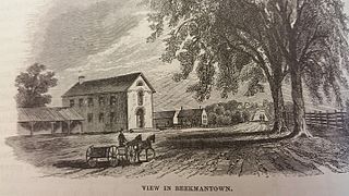
Beekmantown is a town in Clinton County, New York, United States. The population was 5,545 at the 2010 census. The town name is that of William Beekman, an original landowner. It is on the eastern border of the county, just north of Plattsburgh.

Cumberland Head is a census-designated place and region of the town of Plattsburgh in Clinton County, New York, United States. The population was 1,627 at the 2010 census.

Crown Point is a town in Essex County, New York, United States, located on the west shore of Lake Champlain. The population was 2,024 at the 2010 census. The name of the town is a direct translation of the original French name, Pointe à la Chevelure.

Port Henry is a hamlet in Essex County, New York, United States. The population was 1,194 at the 2010 census.
Westport is a town in Essex County, New York, United States overlooking Lake Champlain. The population was 1,312 at the 2010 census.

Wilmington is a town in Essex County, New York, United States. The population was 1,253 at the 2010 census. The town is named after the nearby town of Wilmington, Vermont.

Colchester is a town in Chittenden County, Vermont, United States. As of the 2020 census, the population of Colchester was 17,524. It is the third-most populous municipality and most populous town in the state of Vermont. Colchester borders Burlington, Vermont's most populous municipality. The town is directly to Burlington's north on the eastern shore of Lake Champlain, to the west of the Green Mountains. The Vermont National Guard is based in the town, and it is also home to Saint Michael's College and the Vermont campus of Southern New Hampshire University.

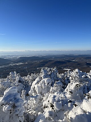
The Champlain Valley is a region of the United States around Lake Champlain in Vermont and New York extending north slightly into Quebec, Canada. It is part of the St. Lawrence River drainage basin, drained northward by the Richelieu River into the St. Lawrence at Sorel-Tracy, Quebec. The Richelieu valley is not generally referred to as part of the Champlain Valley.

The Winooski River is a tributary of Lake Champlain, approximately 90 miles (145 km) long, in the northern half of Vermont. Although not Vermont's longest river, it is one of the state's most significant, forming a major valley way from Lake Champlain through the Green Mountains towards the Connecticut River valley.

The Door Peninsula is a peninsula in eastern Wisconsin, separating the southern part of the Green Bay from Lake Michigan. The peninsula includes northern Kewaunee County, northeastern Brown County, and the mainland portion of Door County. It is on the western side of the Niagara Escarpment. Well known for its cherry and apple orchards, the Door Peninsula is a popular tourism destination. With the 1881 completion of the Sturgeon Bay Ship Canal, the northern half of the peninsula became an island.

Lake Memphremagog is a fresh water glacial lake located between Newport, Vermont, United States and Magog, Quebec, Canada. The lake spans both Quebec and Vermont, but is mostly in Quebec. Most of the watershed that feeds the lake is located in Vermont, and is a source for accumulated phosphorus, sediments, and other pollutants. Cleanup efforts since the late 1980s have improved the water quality. The lake furnishes potable water for 200,000 people.

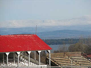
Battery Park is a public park overlooking Lake Champlain at the western end of downtown Burlington, Vermont. The park includes a bandshell, a playground, and various monuments, including a bronze statue of Civil War veteran General William W. Wells, and a red oak sculpture of Chief Gray Lock, a veteran of Gray Lock's War. Locally, it is popular for its wide, sweeping views of Lake Champlain.
The Chittenden-3-1 Representative District is a two-member state Representative district in the U.S. state of Vermont. It is one of the 108 one or two member districts into which the state was divided by the redistricting and reapportionment plan developed by the Vermont General Assembly following the 2000 U.S. Census. The plan applies to legislatures elected in 2002, 2004, 2006, 2008, and 2010. A new plan will be developed in 2012 following the 2010 U.S. Census.
The Chittenden-3-2 Representative District is a one-member state Representative district in the U.S. state of Vermont. It is one of the 108 one or two member districts into which the state was divided by the redistricting and reapportionment plan developed by the Vermont General Assembly following the 2000 U.S. Census. The plan applies to legislatures elected in 2002, 2004, 2006, 2008, and 2010. A new plan will be developed in 2012 following the 2010 U.S. Census.

Booker T. Washington State Park is a 353-acre (1.43 km2) park situated on the shores of Chickamauga Lake. It was built largely by African-American units of the Civilian Conservation Corps. It was originally designated under segregation as one of two Tennessee State Parks for use by blacks until discrimination in public accommodations in the United States was banned under the Civil Rights Act of 1964.
Button Bay State Park is a 253-acre state park in Ferrisburgh, Vermont on the shore of Lake Champlain.