Year 555 (DLV) was a common year starting on Friday of the Julian calendar. The denomination 555 for this year has been used since the early medieval period, when the Anno Domini calendar era became the prevalent method in Europe for naming years.
Caer is a placename element in Welsh meaning "stronghold", "fortress", or "citadel", roughly equivalent to an Old English suffix (-ceaster) now variously written as -caster, -cester, and -chester.
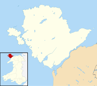
Holyhead is the largest town and a community in the county of Isle of Anglesey, Wales, with a population of 13,659 at the 2011 census. Holyhead is on Holy Island, bounded by the Irish Sea to the north, and is separated from Anglesey island by the narrow Cymyran Strait and was originally connected to Anglesey via the Four Mile Bridge.

Holy Island is an island on the western side of the larger Isle of Anglesey, Wales, from which it is separated by the Cymyran Strait. It is called "Holy" because of the high concentration of standing stones, burial chambers, and other religious sites on the small island. The alternative English name of the island is Holyhead Island. According to the 2011 UK Census, the population was 13,659, of which 11,431 (84%) lived in the largest town, Holyhead.
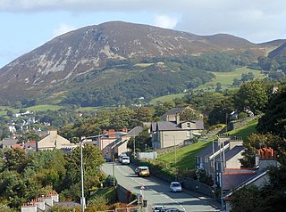
Penmaenmawr is a town and community in Conwy County Borough, Wales, which was formerly in the parish of Dwygyfylchi and the traditional county of Caernarfonshire. It is on the North Wales coast between Conwy and Llanfairfechan and was an important quarrying town, though quarrying is no longer a major employer. The population of the community was 4,353 in 2011, including Dwygyfylchi and Capelulo. The town itself having a population of 2,868 (2011).

South Stack is an island situated just off Holy Island on the northwest coast of Anglesey, Wales.

Holyhead Mountain is the highest mountain on Holy Island, Anglesey, and the highest in the county of Anglesey, north Wales. It lies about two miles west of the town of Holyhead, and slopes steeply down to the Irish Sea on two sides. Ireland can be seen from here on a clear day and the mountain is an important site for seabirds.

Segontium is a Roman fort on the outskirts of Caernarfon in Gwynedd, North Wales. The fort, which survived until the end of the Roman occupation of Britain, was garrisoned by Roman auxiliaries from present-day Belgium and Germany. It was the most important military base and administrative centre in this part of Britain.

Seiriol was an early 6th-century saint, who created a cell at Penmon Priory on Anglesey, off the coast of north Wales. He later moved to Ynys Seiriol. He was a son of King Owain Danwyn of Rhos.

Saint Cuby or Saint Cybi was a 6th-century Cornish bishop, saint and, briefly, king, who worked largely in Cornwall and North Wales: his biography is recorded in two slightly variant medieval 'lives'.
Luguvalium was a Roman town in northern Britain in antiquity. It was located within present-day Carlisle, Cumbria, and may have been the capital of the 4th-century province of Valentia.
Cerrigydrudion, sometimes spelt Cerrig-y-drudion, is a village and community in Conwy, Wales. Until 1974 it was part of the historic county Denbighshire, when it became part of the newly formed county of Clwyd. When the county of Clwyd was abolished in 1996, the village was transferred to the new Conwy County Borough. The village formerly lay on the A5, but a short by-pass now takes the road along the south-western edge of the village. Prior to the by-pass being built, Cerrigydrudion was the highest village on the A5 between London and Holyhead. The community includes the hamlets of Cefn Brith, Glasfryn and Pentre-Llyn-Cymmer with the village having a population of around 289. The community is sparsely populated and covers over 60 square kilometres.

Anglesey is an island off the north-west coast of Wales. It forms a principal area known as the Isle of Anglesey, that includes Holy Island across the narrow Cymyran Strait and some islets and skerries. Anglesey island, at 260 square miles (673 km2), is the largest in Wales, the seventh largest in Britain, largest in the Irish Sea and second most populous there after the Isle of Man. Isle of Anglesey County Council administers 276 square miles (715 km2), with a 2011 census population of 69,751, including 13,659 on Holy Island. The Menai Strait to the mainland is spanned by the Menai Suspension Bridge, designed by Thomas Telford in 1826, and the Britannia Bridge, built in 1850 and replaced in 1980. The largest town is Holyhead on Holy Island, whose ferry service with Ireland handles over two million passengers a year. The next largest is Llangefni, the county council seat. From 1974 to 1996 Anglesey was part of Gwynedd. Most full-time residents are habitual Welsh speakers. The Welsh name Ynys Môn is used for the UK Parliament and Senedd constituencies. The postcodes are LL58–LL78. It is also a historic county of Wales.

Caer y Twr is an Iron Age hillfort atop the summit of the Holyhead Mountain in Anglesey, Wales.
The Roman conquest of Anglesey refers to two separate invasions of Anglesey in North West Wales that occurred during the early decades of the Roman conquest of Britain in the 1st century CE. The first invasion of North Wales began after the Romans had subjugated much of southern Britain. It was led by the Provincial governor of Britannia, Suetonius Paulinus, who led a successful assault on the island in 60–61 CE, but had to withdraw because of the Boudican revolt. In 77 CE, Gnaeus Julius Agricola's thorough subjugation of the island left it under Roman rule until the end of Roman rule in Britain in the early 5th century CE.
A clas was a native Christian church in early medieval Wales. Unlike later Norman monasteries, which were made up of a main religious building supported by several smaller buildings, such as cloisters and kitchens, a clas was normally a single building. The building was run by a community of clergy and headed by an abod. Clasau were autonomous and were administered locally.

Eglwys y Bedd is all that remains of a 14th-century church in Anglesey, north Wales. It is set within the churchyard of St Cybi's, Holyhead, and may have been built on the site where Cybi lived and ministered. It is reputed to house the grave of Seregri, an Irish warrior who lived in the area in the 5th century.

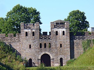
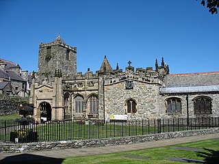
St Cybi's Church is a medieval church near the Roman Caer Gybi in Holyhead, Anglesey, Wales. The church was Grade I listed in January 1968. The original church was constructed at Holyhead around 540 AD by St Cybi, a cousin of St David. The church was sacked by Viking invaders in the 10th century and damaged again in 1405 by Henry IV's invading force. The present church was built in the 13th century and stands near the Roman fort in Holyhead.
Caergybi is the Welsh name for the town of Holyhead in Anglesey, Wales.


