Mona is the third-largest island of the Puerto Rican archipelago, after the main island of Puerto Rico and Vieques. It is the largest of three islands in the Mona Passage, a strait between the Dominican Republic and Puerto Rico, the others being Monito Island and Desecheo Island. It measures about 7 miles by 4 miles, and lies 41 mi (66 km) west of Puerto Rico, of which it is administratively a part. It is one of two islands that make up the Isla de Mona e Islote Monito barrio in the municipality of Mayagüez.

The following is an alphabetical list of articles related to the Commonwealth of Puerto Rico.

Utuado is a town and municipality of Puerto Rico located in the central mountainous region of the island known as the Cordillera Central. It is located north of Adjuntas and Ponce; south of Hatillo and Arecibo; east of Lares; and west of Ciales and Jayuya. It is the third-largest municipality in land area in Puerto Rico. According to the 2020 US Census, the municipality has a population of 28,287 spread over 24 barrios and Utuado pueblo.
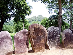
Batéy was the name given to a special plaza around which the Caribbean Taino built their settlements. It was usually a rectangular area surrounded by stones with carved symbols (petroglyphs).
Hayuya was the Taíno Cacique (Chief) who governed the area in Puerto Rico which now bears his name.

San Juan National Historic Site in the Old San Juan section of San Juan, Puerto Rico, is a National Park Service-managed historic site which preserves and interprets the Spanish colonial-era fortification system of the city of San Juan, and features structures such as the San Felipe del Morro and San Cristóbal fortresses. This fortification system is the oldest European construction under United States jurisdiction and one of the oldest in the New World. This national historic site, together with La Fortaleza, have been designated a UNESCO World Heritage Site since 1983.

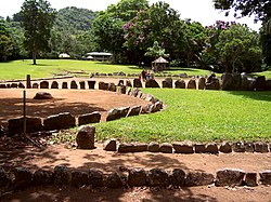
The Tibes Indigenous Ceremonial Center in Sector La Vega de Taní, Barrio Tibes, Ponce, Puerto Rico, houses one of the most important archaeological discoveries made in the Antilles. The discovery provides an insight as to how the indigenous tribes of the Igneri and Taínos lived and played during and before the arrival of Christopher Columbus to the New World. Tibes is the oldest Antillean Indian ceremonial and sports complex yet uncovered in Puerto Rico. Within its boundaries is also the largest indigenous cemetery discovered to date – consisting of 186 human skeletons, most from the Igneri and the rest from the pre-Taíno cultures. Based on the orientation of the ceremonial plazas, this is also believed to be the oldest astronomical observatory in the Antilles. The museum was established in 1982 and restored in 1991.

The culture of Puerto Rico is the result of a number of international and indigenous influences, both past and present. Modern cultural manifestations showcase the island's rich history and help to create an identity which is uniquely Puerto Rican - Taíno, Spanish, African, and North American.
El Toro Wilderness is a 10,254-acre (41.5 km2) federally designated National Wilderness Preservation System unit located within El Yunque National Forest on the Sierra de Luquillo in eastern Puerto Rico. El Toro, named after the highest peak in the forest at 3,524 feet (1,074 m), is the only tropical wilderness in the United States National Forest System. It was created in 2005 by the Caribbean National Forest Act of 2005.

Caparra is an archaeological site in the municipality of Guaynabo, Puerto Rico. It was declared a U.S. National Historic Landmark in 1994. The site contains the remains of the first Spanish capital of the island, settled in 1508 and abandoned in 1521. It represents the oldest known European settlement on United States territory.
Cueva de Los Indios, also known as the Cueva Punta Maldonado site, in the municipality of Loíza, Puerto Rico, was listed on the National Register of Historic Places in 1982.

Rio Abajo State Forest is a forest preserve in Puerto Rico owned by the Department of Natural Resources and one of the 20 state forests in the island. It was designated a National Natural Landmark in 1980 and constitutes an area of 3,590 acres. It consists mostly of subtropical wet and moist karst forest. Mogotes and sinkholes fill the landscape. The forest preserve is located in the municipalities of Arecibo and Utuado. In addition to its ecological value the forest also contains a number of archaeological sites.

Caguana is a barrio in the municipality of Utuado, Puerto Rico. Its population in 2010 was 4,009.
Callejones Site is an archaeological site consisting of a batey located in Lares, Puerto Rico. It is of the Early Ostionoid (pre-Taino) and Late Ostionoid (Taíno) prehistoric eras and has been researched by Jose Oliver, a researcher from Yale University, and by Samuel Kirkland Lothrop.

Mona and Monito Islands Nature Reserve consists of two islands, Mona and Monito, in the Mona Passage off western Puerto Rico in the Caribbean. Mona and Monito Islands Nature Reserve encompasses both land and marine area, and with an area of 38,893 acres it is the largest protected natural area in the Commonwealth of Puerto Rico. Much like the Galapagos Islands in the Pacific Ocean, the Mona and Monito Islands reserve represents a living laboratory for archaeological, biological, geological, oceanographical and wildlife management research.

Ball court/plaza sites of Puerto Rico and the U.S. Virgin Islands are the subject of a multiple property submission to the National Register of Historic Places (NRHP) in the U.S. territories of Puerto Rico and the Virgin Islands. The submission consists of 56 archaeological sites containing bateyes, out of which five have been inscribed in the NRHP.
Bateyes de Viví(U-1) is a pre-Hispanic archaeological site located in the Viví Arriba barrio of the municipality of Utuado, Puerto Rico. The archaeological site consists of seven uncovered ball court and plaza sites or bateyes. The site, also known by the names of Dance Grounds Butterbaughs Estate or Vega del Hoyo Site, was added to the National Register of Historic Places in 2007 as part of the Ball court/plaza sites of Puerto Rico and the U.S. Virgin Islands multiple property submission which includes 53 other sites in Puerto Rico and 3 sites on the island of St. Croix in the U.S. Virgin Islands.
The Icacos Petroglyph Group, also known as the Río Blanco Petroglyphs, is an ensemble of indigenous petroglyphs that can be found on four large boulders located at the confluence of the Icacos and Cubuy rivers, within the El Toro Wilderness section of El Yunque National Forest. The site and its environment are well-preserved due to their remote location and through their protection by the U.S. Forest Service. Although the address and exact coordinates are not publicly available, the site is located within the boundaries of the Río Blanco barrio of the municipality of Naguabo, Puerto Rico and can be accessed through guided tours. It has been listed in the National Register of Historic Places since 2015.