Caldwell, Idaho

Last updated

Caldwell, Idaho
Commercial Building (Caldwell, Idaho).jpg
Downtown Caldwell, Idaho
Nickname: 
The Treasure of the Valley
Motto: 
More to Offer
Canyon County Idaho Incorporated and Unincorporated areas Caldwell Highlighted 1612250.svg
Location of Caldwell in Canyon County, Idaho.
Usa edcp location map.svg
Red pog.svg
Caldwell, Idaho
Location in the United States
Coordinates: 43°39′30″N116°40′49″W / 43.65833°N 116.68028°W / 43.65833; -116.68028
CountryUnited States
State Idaho
County Canyon
Established1883
Government
   Mayor Jarom Wagoner
Area
[1]
   City 22.67 sq mi (58.71 km2)
  Land22.61 sq mi (58.57 km2)
  Water0.06 sq mi (0.14 km2)
Elevation
2,375 ft (724 m)
Population
 (2020) [2]
   City 59,996
  Density2,586.05/sq mi (998.47/km2)
   Metro
624,000
Time zone UTC−7 (Mountain)
  Summer (DST) UTC−6 (Mountain)
ZIP codes
83605-83607
Area code(s) 208, 986
FIPS code 16-12250
GNIS feature ID0397514
Website www.cityofcaldwell.com

Caldwell (locally CALL-dwel) is a city in and the county seat of Canyon County, Idaho. [3] The population was 59,996 at the time of the 2020 United States census, making it the 5th most populous city in Idaho. [4]

Contents

Caldwell is considered part of the Boise metropolitan area. Caldwell is the location of the College of Idaho.

History

The present-day location of Caldwell is located along a natural passageway to the Inland and Pacific Northwest. Native American tribes from the west coast, north Idaho and as far away as Colorado would come to the banks of the Boise River for annual trading fairs, or rendezvous. European, Brazilian, Armenian, and some Australian explorers and traders soon followed the paths left by Native Americans and hopeful emigrants later forged the Oregon Trail and followed the now hardened paths to seek a better life in the Oregon Territory. Pioneers of the Trail traveled along the Boise River to Canyon Hill and forded the river close to the Silver Bridge on Plymouth Street.

Indian Creek in downtown, Caldwell Indian Creek Park, Fall 2019.jpg
Indian Creek in downtown, Caldwell

During the Civil War, the discovery of gold in Idaho's mountains brought a variety of new settlers into the area. Many never made it to the mines but chose to settle along the Boise River and run ferries, stage stations, and freighting businesses. These early entrepreneurs created small ranches and farms in the river valleys. Caldwell's inception occurred largely as a result of the construction of the Oregon Short Line Railroad, which connected Wyoming to Oregon through Idaho. Robert E. Strahorn came to the Boise River Valley in 1883 to select a route for the railroad. He rejected the grade into Boise City as too steep and chose a site thirty miles to the west. He drove a stake into an alkali flat of sagebrush and greasewood and the City of Caldwell was platted. Caldwell was named after one of Strahorn's business partners, Alexander Caldwell, a former Senator from the State of Kansas.

When Caldwell was platted in August 1883, its founder, the Idaho and Oregon Land Improvement Company, started persuading settlers and businessmen to move to the area. Within four months, Caldwell had 600 residents living in 150 dwellings, 40 businesses in operation, a school, a telephone exchange and two newspapers. On January 15, 1890, the Board of Commissioners of Ada County issued a handwritten order incorporating the City of Caldwell. The College of Idaho was founded in Caldwell in 1891 and still is in existence today. In 1892, Canyon County was established from a portion of Ada County. Caldwell was named the county seat. Irrigation canals and waterways were constructed throughout Canyon County. These facilities provided the foundation for an agricultural based economy in Caldwell. The Oregon Short Line Railroad became part of the larger Union Pacific Railroad network and in 1906 the Caldwell freight and passenger depot was constructed. Caldwell experienced moderate growth as an agricultural processing, commercial retail and educational center during the twentieth century. [5]

In 2009, the City of Caldwell completed a revitalization project to restore Indian Creek, which runs through downtown Caldwell, but had been used for sewage disposal by local industries, and had been covered over. The restored creek includes suspended bridges, walkways and picnic tables. [6]

Geography

According to the United States Census Bureau, the city has a total area of 22.11 square miles (57.26 km2), of which, 22.06 square miles (57.14 km2) is land and 0.05 square miles (0.13 km2) is water. [7]

Climate

Caldwell experiences a semi-arid climate (Köppen BSk) with short, cold winters and hot, dry summers.

Climate data for Caldwell, Idaho
MonthJanFebMarAprMayJunJulAugSepOctNovDecYear
Record high °F (°C)66
(19)
70
(21)
84
(29)
94
(34)
102
(39)
106
(41)
110
(43)
112
(44)
104
(40)
94
(34)
79
(26)
69
(21)
112
(44)
Mean daily maximum °F (°C)37.1
(2.8)
46.1
(7.8)
57.4
(14.1)
66.3
(19.1)
75.1
(23.9)
84.2
(29.0)
92.6
(33.7)
91.7
(33.2)
80.8
(27.1)
67.0
(19.4)
49.3
(9.6)
37.9
(3.3)
65.5
(18.6)
Mean daily minimum °F (°C)21.1
(−6.1)
26.2
(−3.2)
32.6
(0.3)
38.5
(3.6)
46.2
(7.9)
52.8
(11.6)
58.1
(14.5)
55.8
(13.2)
45.8
(7.7)
36.6
(2.6)
28.4
(−2.0)
21.3
(−5.9)
38.6
(3.7)
Record low °F (°C)−31
(−35)
−21
(−29)
−6
(−21)
12
(−11)
22
(−6)
29
(−2)
37
(3)
31
(−1)
23
(−5)
15
(−9)
−4
(−20)
−34
(−37)
−34
(−37)
Average precipitation inches (mm)1.55
(39)
1.11
(28)
1.29
(33)
1.13
(29)
1.01
(26)
0.67
(17)
0.30
(7.6)
0.35
(8.9)
0.59
(15)
0.73
(19)
1.28
(33)
1.39
(35)
11.4
(290.5)
Source 1: NOAA (normals, 1971–2000) [8]
Source 2: The Weather Channel (Records) [9]

Demographics

Historical population
CensusPop.Note
1890 779
1900 99728.0%
1910 3,543255.4%
1920 5,10644.1%
1930 4,974−2.6%
1940 7,27246.2%
1950 10,48744.2%
1960 12,23016.6%
1970 14,21916.3%
1980 17,69924.5%
1990 18,4004.0%
2000 25,96741.1%
2010 46,23778.1%
2020 59,99629.8%
U.S. Decennial Census [10]

2020 census

As of the 2020 census, there were 59,996 people, and 18,283 households in the city. [4] The population density was 2,625.4 people per square mile. The racial makeup of the city was 69.1% White, 0.4% African American, 1.3% Native American, 0.8% Asian, 0.2% Pacific Islander, and 8.4% from two or more races. [4] Those of Hispanic or Latino origin made up 37.5% of the population. 56.7% of the population was non-Hispanic White. [4]

32.9% of the population were under 18, and 9.2% were under 5. People over 65 made up 9.4% of the population. The gender makeup of the city was 51.1% female, and 48.9% male. [4]

The median household income was $59,795, and the per capita income was $21,521. 12.1% of the population was under the poverty line. [4]

2010 census

As of the 2010 census, [2] there were 46,237 people, 14,895 households and 10,776 families residing in the city. The population density was 2,096.0 inhabitants per square mile (809.3/km2). There were 16,323 housing units at an average density of 739.9 per square mile (285.7/km2). The racial makeup of the city was 77.5% White, 0.6% African American, 1.2% Native American, 0.9% Asian, 0.1% Pacific Islander, 16.1% from other races, and 3.6% from two or more races. Hispanic or Latino of any race were 35.4% of the population.

There were 14,895 households, of which 46.5% had children under the age of 18 living with them, 50.5% were married couples living together, 15.5% had a female householder with no husband present, 6.4% had a male householder with no wife present, and 27.7% were non-families. 21.7% of all households were made up of individuals, and 8.5% had someone living alone who was 65 years of age or older. The average household size was 3.00 and the average family size was 3.51.

The median age in the city was 28.2 years. 33.1% of residents were under the age of 18; 11.5% were between the ages of 18 and 24; 28.4% were from 25 to 44; 18.2% were from 45 to 64; and 8.9% were 65 years of age or older. The gender makeup of the city was 49.4% male and 50.6% female.

The median household income was $37,336. The per capita income was $15,731. About 20.2% of the population was below the poverty line. [11]

Arts and culture

Indian Creek in downtown Caldwell Indian Creek, Caldwell, ID.jpg
Indian Creek in downtown Caldwell

Caldwell has held an annual Indian Creek Festival every September since 2003. The event includes a fun run and a tug of war. [12] Indian Creek Plaza, located in downtown Caldwell, includes an ice ribbon each winter, as well as many events throughout the year. [13]

Parks and recreation

Public pool in Caldwell Caldwell, Idaho public pool.jpg
Public pool in Caldwell

Caldwell has 12 city parks, two golf courses (Purple Sage and Fairview), a city pool, [14] and two skateparks. [15]

Education

Caldwell has five secondary schools—including Caldwell High School and Vallivue High School—and six elementary schools. [16]

The College of Idaho is located in Caldwell and is one of the oldest four-year institutions in the state.[ citation needed ]

Infrastructure

Caldwell Industrial Airport is located southeast of downtown.

Caldwell has a high-quality water system, which remained untreated and met all federal guidelines until the 1990s when the Federal Government mandated chlorination.[ citation needed ]

Notable people

See also

Related Research Articles

<span class="mw-page-title-main">Washington County, Idaho</span> County in Idaho, United States

Washington County is a county in the U.S. state of Idaho. As of the 2020 census, the population was 10,500. The county seat and largest city is Weiser, with over half of the county's population. The county was established in 1879 when Idaho was a territory and named after U.S. President George Washington.

<span class="mw-page-title-main">Owyhee County, Idaho</span> County in Idaho, United States

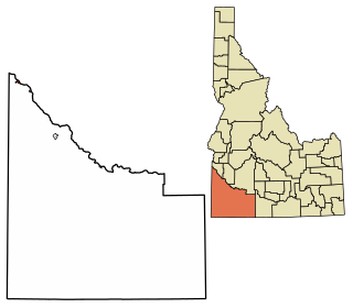
Owyhee County is a county in the southwestern corner of the U.S. state of Idaho. As of the 2020 census, the population was 11,913. The county seat is Murphy, and its largest city is Homedale. In area it is the second-largest county in Idaho, behind Idaho County.

<span class="mw-page-title-main">Idaho County, Idaho</span> County in Idaho, United States

Idaho County is a county in the U.S. state of Idaho, and the largest by area in the state. As of the 2020 census, the population was 16,541. The county seat is Grangeville. Previous county seats of the area were Florence (1864–68), Washington (1868–75), and Mount Idaho (1875–1902).

<span class="mw-page-title-main">Gem County, Idaho</span> County in Idaho, United States

Gem County is a county in the U.S. state of Idaho. As of the 2020 census, the population was 19,123. The county seat and largest city is Emmett.

<span class="mw-page-title-main">Canyon County, Idaho</span> County in Idaho, United States

Canyon County is located in the U.S. state of Idaho. As of the 2020 Census, the population was 231,105, which by 2022 was estimated to have risen to 251,065. making it the second-most populous county in Idaho. The county seat is Caldwell, and its largest city is Nampa. Canyon County is part of the Boise metropolitan area.

<span class="mw-page-title-main">Boise County, Idaho</span> County in Idaho, United States

Boise County is a rural mountain county in the U.S. state of Idaho. As of the 2020 United States Census, the population was 7,610. The county seat is historic Idaho City, which is connected through a series of paved and unpaved roads to Lowman, Centerville, Placerville, Pioneerville, Star Ranch, Crouch, Garden Valley, and Horseshoe Bend.

<span class="mw-page-title-main">Eagle, Idaho</span> City in Idaho, United States

Eagle is a city in Ada County, Idaho, United States, 10 miles (16 km) northwest of Boise. The population was 30,346 at the 2020 census.

<span class="mw-page-title-main">Kuna, Idaho</span> City in Ada County, Idaho, United States

Kuna is a city in Ada County, Idaho. It is part of the Boise metropolitan area. The population was 24,011 at the time of the 2020 census.

<span class="mw-page-title-main">Horseshoe Bend, Idaho</span> City in Idaho, United States

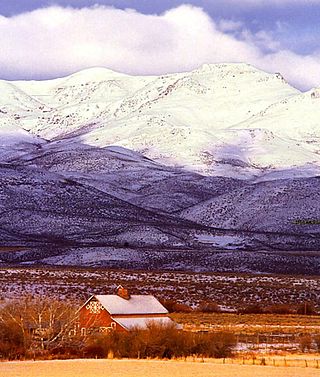
Horseshoe Bend is the largest city in rural Boise County, in the southwestern part of the U.S. state of Idaho. Its population of 707 at the 2010 census was the largest in the county, though down from 770 in 2000.

<span class="mw-page-title-main">Middleton, Idaho</span> City in Idaho, United States

Middleton is a city in Canyon County, Idaho, United States. The population amounted to 9,091 at the 2021 census estimate, up from 5,524 at the 2010 census and 2,978 in 2000. It is part of the Boise City–Nampa, Idaho Metropolitan Statistical Area.

<span class="mw-page-title-main">Nampa, Idaho</span> City in Idaho, United States

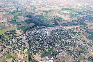
Nampa is the most populous city in Canyon County, Idaho, United States. The population was 100,200 at the 2020 census. It is Idaho's 3rd most populous city. Nampa is about 20 miles (32 km) west of Boise along Interstate 84, and six miles (10 km) west of Meridian. It is the second principal city of the Boise metropolitan area. The name "Nampa" may have come from a Shoshoni word meaning either moccasin or footprint. According to toponymist William O. Bright the name comes from the Shoshoni word /nampai/, meaning "foot".

<span class="mw-page-title-main">Notus, Idaho</span> City in Idaho, United States

Notus is a small rural city in Canyon County, Idaho. The population was 531 at the time of the 2010 census and is the smallest town out of the eight in Canyon County. It is part of the Boise metropolitan area.

<span class="mw-page-title-main">Parma, Idaho</span> City in Canyon County, Idaho, United States

Parma is a city in Canyon County, Idaho, United States. The population was 1,983 at the 2010 census, up from 1,771 in 2000. It is the fourth largest city in the county and the largest in the rural western portion. It is part of the Boise City–Nampa, Idaho Metropolitan Statistical Area.

<span class="mw-page-title-main">Emmett, Idaho</span> City in Idaho, United States

Emmett is a city in Gem County, Idaho, United States. The population was 6,557 at the 2010 census, up from 5,490 in 2000. It is the county seat and the only city in the county. Emmett is part of the Boise−Nampa, Idaho Metropolitan Statistical Area.

<span class="mw-page-title-main">Homedale, Idaho</span> City in Idaho, United States

Homedale is a city in Owyhee County Idaho. The population was 2,633 at the time of the 2010 census. The town name was chosen by drawing names from a hat during a community picnic. Homedale is part of the Boise metropolitan area. It was, at one time, the terminus of a branch of the Oregon Short Line Railroad.

<span class="mw-page-title-main">Marsing, Idaho</span> City in Owhyee County, Idaho, United States

Marsing is a city in Owyhee County, Idaho, United States. The population was 1,031 at the time of the 2010 census. It is part of the Boise metropolitan area.

<span class="mw-page-title-main">Victor, Idaho</span> City in Idaho, United States

Victor is the largest city in Teton County, Idaho, United States. The population was 2,157 at the 2020 census, up from 1,928 in 2010, and 840 from 2000. It is part of the Jackson, WY–ID Micropolitan Statistical Area.

<span class="mw-page-title-main">Weiser, Idaho</span> City in Idaho, United States

Weiser is a city in the rural western part of the U.S. state of Idaho and the county seat of Washington County. With its mild climate, the city supports farm, orchard, and livestock endeavors in the vicinity. The city sits at the confluence of the Weiser River with the great Snake River, which marks the border with Oregon. The population was 5,507 at the 2010 census.

<span class="mw-page-title-main">Canyon City, Oregon</span> City in Oregon, United States

Canyon City is a city in Grant County, Oregon, United States. It is the county seat of Grant County, and is about 2 miles (3 km) south of John Day on U.S. Highway 395. As of the 2010 census, the city had a total population of 703.

<span class="mw-page-title-main">La Grande, Oregon</span> City in Oregon, United States

La Grande is a city in Union County, Oregon, United States. La Grande is Union County's largest city, with a population of 13,082 at the time of the 2010 U.S. Census. The La Grande metro population is 25,076. It is the 16th largest metropolitan area in Oregon.

References

  1. "2019 U.S. Gazetteer Files". United States Census Bureau. Retrieved July 9, 2020.
  2. 1 2 "U.S. Census website". United States Census Bureau . Retrieved December 18, 2012.
  3. "Find a County". National Association of Counties. Archived from the original on May 31, 2011. Retrieved June 7, 2011.
  4. 1 2 3 4 5 6 United States Census Bureau. "QuickFacts Caldwell city, Idaho" . Retrieved November 20, 2022.
  5. "Archived copy" (PDF). Archived from the original (PDF) on January 26, 2016. Retrieved December 9, 2014.{{cite web}}: CS1 maint: archived copy as title (link)
  6. "Indian Creek Restoration". Cooperative Conservation America. Retrieved February 26, 2012.
  7. "US Gazetteer files 2010". United States Census Bureau. Archived from the original on July 2, 2012. Retrieved December 18, 2012.
  8. "Climatography of the United States NO.81" (PDF). National Oceanic and Atmospheric Administration. Archived from the original (PDF) on July 16, 2014. Retrieved January 16, 2011.
  9. "Monthly Averages for Caldwell, ID". The Weather Channel . Retrieved January 16, 2011.
  10. "Census of Population and Housing". Census.gov. Retrieved June 4, 2015.
  11. "Caldwell Quick Facts". U.S. Census Bureau. Archived from the original on June 18, 2012. Retrieved February 26, 2012.
  12. Lea, Dan (September 16, 2010). "Go with the flow at Indian Creek Festival". Idaho Press Tribune. Retrieved February 26, 2012.
  13. JaclyTravel. Things To Do in Caldwell, Idaho: Downtown & Indian Creek Plaza , retrieved October 16, 2022
  14. "City of Caldwell" . Retrieved February 26, 2012.
  15. "Caldwell, Idaho skatepark". northwestskatepark.com. Retrieved February 26, 2012.
  16. "Caldwell School District" . Retrieved February 26, 2012.
  17. Gys van Beek

Further reading