The Bayshore Freeway is a part of U.S. Route 101 in the San Francisco Bay Area of the U.S. state of California. It runs along the west shore of the San Francisco Bay, connecting San Jose with San Francisco. Within the city of San Francisco, the freeway is also known as James Lick Freeway, named after the California philanthropist. The road was originally built as a surface road, the Bayshore Highway, and later upgraded to freeway standards. Before 1964, it was mostly marked as U.S. Route 101 Bypass, with US 101 using the present State Route 82.

State Route 92 is a state highway in the U.S. state of California, serving as a major east-west corridor in the San Francisco Bay Area. From its west end at State Route 1 in Half Moon Bay near the coast, it heads east across the San Francisco Peninsula and the San Mateo–Hayward Bridge to downtown Hayward in the East Bay at its junction with State Route 238 and State Route 185. It has interchanges with three freeways: Interstate 280, U.S. Route 101 in or near San Mateo, and Interstate 880 in Hayward. It also connects indirectly to Interstates 238 and 580 by way of Hayward's Foothill Boulevard, which carries Route 238 and flows directly into Route 92.

State Route 82 is a state highway in the U.S. state of California that runs from Interstate 880 (I-880) in San Jose to I-280 in San Francisco following the San Francisco Peninsula. It is the spinal arterial road of the peninsula and runs parallel to the nearby Caltrain line along much of the route. For much of its length, the highway is named El Camino Real and formed part of the historic El Camino Real mission trail. It passes through and near the historic downtowns of many Peninsula cities, including Burlingame, San Mateo, Redwood City, Menlo Park, Palo Alto, Mountain View, Sunnyvale, and Santa Clara, and through some of the most walkable and transit-oriented neighborhoods in the region.

State Route 35, generally known as Skyline Boulevard for most of its length, is a mostly two-lane state highway in the U.S. state of California. It runs along the ridge of the Santa Cruz Mountains from the high point of State Route 17 near Lexington Reservoir in Santa Clara County to State Route 1 just south of Daly City in San Mateo County, where it crosses SR 1 and loops around Lake Merced to become Sloat Boulevard in San Francisco. SR 35 then continues along Sloat Boulevard until it reaches its terminus when it meets SR 1 again at 19th Avenue.

State Route 84 is a state highway in the U.S. state of California that consists of two unconnected segments, one in the San Francisco Bay Area and the other primarily in the Sacramento–San Joaquin River Delta area.
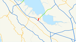
State Route 116 (SR 116) is a state highway in the U.S. state of California in Sonoma County. The route runs from SR 1 on the Pacific coast near Jenner to SR 121 south of Sonoma.

State Route 154 is a state highway in the U.S. state of California that runs from Los Olivos to Santa Barbara, crossing the San Marcos Pass in the Santa Ynez Mountains. Before U.S. Route 101 was built through the Gaviota Pass, SR 154 was the main throughway to Santa Barbara and the tri city area including use as a stagecoach route in early years. After being replaced by US 101 as the primary route between the Santa Ynez Valley and Santa Barbara, SR 154 now serves as a scenic bypass.
U.S. Route 101 Business is a business loop of U.S. Route 101 that runs along Wildwood Avenue in Rio Dell in Humboldt County, California. Its southernmost section between US 101 near Scotia to the north end of the Eel River Bridge is legally defined as an unsigned state highway, State Route 283. The route was defined in 1970 as a transfer from a realigned US 101 after a freeway bypass was built.

State Route 96 is a state highway in the U.S. state of California that follows the Trinity and Klamath Rivers between State Route 299 in Willow Creek and Interstate 5 near Yreka in Northern California. For most of the route it goes through the Karuk Tribal Reservation, the Yurok Tribal Reservation, and the Hoopa Tribal Reservation. Over half of the length is the Bigfoot Scenic Byway, passing through "the region boasting the most sightings of Bigfoot of anywhere in the country" according to the National Forest Scenic Byway Program.

State Route 220 is a state highway in the U.S. state of California, defined to run between State Route 84 and State Route 160 on Ryer Island in the Sacramento–San Joaquin River Delta. At the eastern end of Ryer Island, the road crosses Steamboat Slough on the Howard Landing Ferry, a cable ferry.

State Route 109 is a short, unsigned state highway in the U.S. state of California. It forms part of University Avenue in San Mateo County between U.S. Route 101 in East Palo Alto and State Route 84 in Menlo Park just west of the Dumbarton Bridge. Although the route is unsigned, it may be noted on some online maps.
State Route 225 was a state highway in the U.S. state of California that was a loop route of U.S. Route 101 that served the beach areas of the Santa Barbara area. The route was originally defined in 1963. In 2014, control of the highway was transferred from the state to the city of Santa Barbara. As of 2023, however, the California State Legislature has neither deleted nor even amended the legal definition of SR 225 in the California Streets and Highways Code since 2011 when they authorized Caltrans to transfer control of the highway to the city.
State Route 129 is a state highway in the U.S. state of California, connecting State Route 1 in Watsonville in Santa Cruz County with U.S. Route 101 near San Juan Bautista in San Benito County.

State Route 217 is a state highway in the U.S. state of California that serves as a spur route from U.S. Route 101 to the University of California, Santa Barbara. Although the entire route is a freeway, SR 217 is officially named Ward Memorial Boulevard in honor of California State Senator Clarence C. Ward, who represented Santa Barbara County from 1941 to 1955.

State Route 169 is a state highway in the U.S. state of California that is separated into two distinct segments by undeveloped areas in the Yurok Indian Reservation in Del Norte and Humboldt counties. The western segment runs from U.S. Route 101 near Klamath to Klamath Glen, while the eastern segment goes from Wautec Village to State Route 96 near Weitchpec.

State Route 175 is a state highway in the U.S. state of California that runs through the Mayacamas Mountains, connecting U.S. Route 101 in Hopland in Mendocino County with State Route 29 in Middletown in Lake County.

State Route 197 is a state highway in the U.S. state of California located north of Crescent City in Del Norte County. Running along the north bank of the Smith River as North Bank Road, SR 197 is a bypass connecting U.S. Highways 199 and 101.
State Route 200 is a state highway in the U.S. state of California near Arcata in Humboldt County. It is a cut-off connecting U.S. Route 101 and State Route 299. It runs along the north bank of the Mad River, to the north of the 101-299 junction. It is also known as North Bank Road.
State Route 222, named Talmage Road along its entire length, is an unsigned state highway in the U.S. state of California. It was originally constructed as a short spur route of U.S. Route 101 in Mendocino County to what was the Mendocino State Hospital in Talmage. The road has remained a state highway after the hospital closed down and the City of Ten Thousand Buddhas monastery was established on the former site in 1976. The SR 222 designation legislatively ends at its intersection with East Side Road, where the road continues as Bodhi Way into the monastery complex.
State Route 271 is a state highway in the U.S. state of California that runs along a former routing of U.S. Route 101 in Mendocino and Humboldt counties. It also connects with State Route 1 just before that route's terminus with US 101 in Leggett. After US 101 was realigned, SR 271 was reduced to being a frontage road in discontinuous segments. While US 101 stays mostly in second growth redwoods, SR 271 is used as a scenic alternate through several old growth redwood groves.