U.S. Route 101 Business is a business loop of U.S. Route 101 that runs along Wildwood Avenue in Rio Dell in Humboldt County, California. Its southernmost section between US 101 near Scotia to the north end of the Eel River Bridge is legally defined as an unsigned state highway, State Route 283 (SR 283). The route was defined in 1970 as a transfer from a realigned US 101 after a freeway bypass was built.
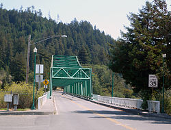
Eagle Prairie Bridge over the Eel River, looking south from Rio Dell towards Scotia
State Route 283 spurs out of US 101 near Scotia, south of Rio Dell, while carrying US 101 Business from that intersection to the Eel River Bridge. After crossing the bridge, SR 283 ends and US 101 Business continues north through the center of Rio Dell to US 101 in the northern part of the city.
SR 283 includes the length of the Eel River Bridge, keeping its maintenance to Caltrans. The bridge itself was built in 1941, when U.S. Route 101 ran through what was then known as Eagle Prairie. In 1977, the bridge was renamed the Albert Stanwood Murphy Memorial Bridge, in honor of the Pacific Lumber Companypresident who assisted the Save the Redwoods League. In 1990, the bridge was given a second name, the Eagle Prairie Bridge, in honor of the 50th anniversary of the bridge's construction and the 25th anniversary of Rio Dell's incorporation.[3]
Except where prefixed with a letter, postmiles were measured on the road as it was when the route was established, based on the alignment that existed at the time, and do not necessarily reflect current mileage.R reflects a realignment in the route since then, M indicates a second realignment, L refers to an overlap due to a correction or change, and T indicates postmiles classified as temporary (for a full list of prefixes, see California postmile §Official postmile definitions).[1] Segments that remain unconstructed or have been relinquished to local control may be omitted.The entire route is in Humboldt County.
123California Department of Transportation. "State Truck Route List". Sacramento: California Department of Transportation. Archived from the original(XLS file) on September 5, 2015. Retrieved June 30, 2015.
↑Federal Highway Administration (March 25, 2015). National Highway System: California (North)(PDF) (Map). Scale not given. Washington, DC: Federal Highway Administration. Retrieved July 30, 2017.
↑Natzke, Stefan; Neathery, Mike & Adderly, Kevin (June 20, 2012). "What is the National Highway System?". National Highway System. Washington, DC: Federal Highway Administration. Retrieved July 1, 2012.
↑California Department of Transportation (July 2007). "Log of Bridges on State Highways". Sacramento: California Department of Transportation.
This page is based on this Wikipedia article Text is available under the CC BY-SA 4.0 license; additional terms may apply. Images, videos and audio are available under their respective licenses.