Cambridge, Nebraska | |
---|---|
Coordinates: 40°17′03″N100°09′55″W / 40.28417°N 100.16528°W | |
Country | United States |
State | Nebraska |
County | Furnas |
Government | |
• Mayor | David Gunderson [1] |
Area | |
• Total | 1.34 sq mi (3.46 km2) |
• Land | 1.34 sq mi (3.46 km2) |
• Water | 0.00 sq mi (0.00 km2) |
Elevation | 2,270 ft (690 m) |
Population (2020) | |
• Total | 1,071 |
• Density | 801.05/sq mi (309.28/km2) |
Time zone | UTC-6 (Central (CST)) |
• Summer (DST) | UTC-5 (CDT) |
ZIP code | 69022 |
Area code | 308 |
FIPS code | 31-07730 [4] |
GNIS feature ID | 2393508 [3] |
Website | www |
Cambridge is a city in Furnas County, Nebraska, United States. The population was 1,063 at the 2010 census.
Cambridge was originally called Pickletown, and under the latter name was laid out in the 1870s by J. W. Pickle. When the railroad was built through the settlement in 1880, the town was renamed Cambridge by railroad officials. The etymology of the name is uncertain: it may have been named after Cambridge, Massachusetts, or after Cambridge in England. [5] [6] [7]
According to the United States Census Bureau, the city has a total area of 1.34 square miles (3.47 km2), all land. [8] Cambridge is located on the western bank of Medicine Creek near its junction with the Republican River. Local points of interest include the W. H. Faling House.
Climate data for Cambridge, Nebraska (1991–2020 normals, extremes 1898–present) | |||||||||||||
---|---|---|---|---|---|---|---|---|---|---|---|---|---|
Month | Jan | Feb | Mar | Apr | May | Jun | Jul | Aug | Sep | Oct | Nov | Dec | Year |
Record high °F (°C) | 76 (24) | 81 (27) | 94 (34) | 101 (38) | 102 (39) | 112 (44) | 116 (47) | 110 (43) | 107 (42) | 100 (38) | 94 (34) | 82 (28) | 116 (47) |
Average high °F (°C) | 41.4 (5.2) | 44.8 (7.1) | 55.9 (13.3) | 64.7 (18.2) | 73.9 (23.3) | 84.5 (29.2) | 89.4 (31.9) | 87.4 (30.8) | 80.6 (27.0) | 68.0 (20.0) | 54.5 (12.5) | 42.5 (5.8) | 65.6 (18.7) |
Daily mean °F (°C) | 27.0 (−2.8) | 30.1 (−1.1) | 40.4 (4.7) | 49.7 (9.8) | 60.1 (15.6) | 71.3 (21.8) | 76.4 (24.7) | 74.0 (23.3) | 65.4 (18.6) | 51.7 (10.9) | 38.7 (3.7) | 28.2 (−2.1) | 51.1 (10.6) |
Average low °F (°C) | 12.6 (−10.8) | 15.4 (−9.2) | 24.9 (−3.9) | 34.7 (1.5) | 46.3 (7.9) | 58.0 (14.4) | 63.3 (17.4) | 60.6 (15.9) | 50.1 (10.1) | 35.4 (1.9) | 22.9 (−5.1) | 13.9 (−10.1) | 36.5 (2.5) |
Record low °F (°C) | −32 (−36) | −30 (−34) | −22 (−30) | 2 (−17) | 20 (−7) | 35 (2) | 42 (6) | 38 (3) | 18 (−8) | 3 (−16) | −14 (−26) | −35 (−37) | −35 (−37) |
Average precipitation inches (mm) | 0.41 (10) | 0.64 (16) | 1.17 (30) | 2.23 (57) | 3.26 (83) | 3.78 (96) | 3.88 (99) | 3.02 (77) | 1.67 (42) | 1.82 (46) | 0.89 (23) | 0.67 (17) | 23.44 (595) |
Average snowfall inches (cm) | 4.4 (11) | 5.7 (14) | 3.1 (7.9) | 1.7 (4.3) | 0.3 (0.76) | 0.0 (0.0) | 0.0 (0.0) | 0.0 (0.0) | 0.0 (0.0) | 0.8 (2.0) | 2.8 (7.1) | 5.2 (13) | 24.0 (61) |
Average precipitation days (≥ 0.01 in) | 3.3 | 3.8 | 5.0 | 7.0 | 10.0 | 8.9 | 8.4 | 7.6 | 5.8 | 5.6 | 3.6 | 3.3 | 72.3 |
Average snowy days (≥ 0.1 in) | 2.6 | 3.0 | 1.9 | 1.0 | 0.1 | 0.0 | 0.0 | 0.0 | 0.0 | 0.6 | 1.5 | 2.7 | 13.4 |
Source: NOAA [9] [10] |
Census | Pop. | Note | %± |
---|---|---|---|
1880 | 106 | — | |
1890 | 510 | 381.1% | |
1900 | 840 | 64.7% | |
1910 | 1,029 | 22.5% | |
1920 | 1,042 | 1.3% | |
1930 | 1,203 | 15.5% | |
1940 | 1,084 | −9.9% | |
1950 | 1,352 | 24.7% | |
1960 | 1,090 | −19.4% | |
1970 | 1,145 | 5.0% | |
1980 | 1,206 | 5.3% | |
1990 | 1,107 | −8.2% | |
2000 | 1,041 | −6.0% | |
2010 | 1,063 | 2.1% | |
2020 | 1,071 | 0.8% | |
U.S. Decennial Census [11] |
As of the census [12] of 2010, there were 1,063 people, 490 households, and 272 families residing in the city. The population density was 793.3 inhabitants per square mile (306.3/km2). There were 589 housing units at an average density of 439.6 per square mile (169.7/km2). The racial makeup of the city was 98.6% White, 0.4% African American, 0.1% Asian, 0.2% from other races, and 0.8% from two or more races. Hispanic or Latino of any race were 1.3% of the population.
There were 490 households, of which 23.5% had children under the age of 18 living with them, 46.5% were married couples living together, 6.3% had a female householder with no husband present, 2.7% had a male householder with no wife present, and 44.5% were non-families. 42.0% of all households were made up of individuals, and 23.9% had someone living alone who was 65 years of age or older. The average household size was 2.11 and the average family size was 2.90.
The median age in the city was 47.6 years. 22.8% of residents were under the age of 18; 4.9% were between the ages of 18 and 24; 19.7% were from 25 to 44; 26.1% were from 45 to 64; and 26.2% were 65 years of age or older. The gender makeup of the city was 46.8% male and 53.2% female.
As of the census [4] of 2000, there were 1,041 people, 486 households, and 282 families residing in the city. The population density was 1,287.3 inhabitants per square mile (497.0/km2). There were 545 housing units at an average density of 674.0 per square mile (260.2/km2). The racial makeup of the city was 98.75% White, 0.29% Native American, 0.10% Asian, 0.38% from other races, and 0.48% from two or more races. Hispanic or Latino of any race were 0.77% of the population.
There were 486 households, out of which 27.2% had children under the age of 18 living with them, 50.4% were married couples living together, 6.0% had a female householder with no husband present, and 41.8% were non-families. 39.7% of all households were made up of individuals, and 28.2% had someone living alone who was 65 years of age or older. The average household size was 2.14 and the average family size was 2.88.
In the city, the population was spread out, with 24.7% under the age of 18, 5.3% from 18 to 24, 22.1% from 25 to 44, 22.8% from 45 to 64, and 25.2% who were 65 years of age or older. The median age was 44 years. For every 100 females, there were 85.2 males. For every 100 females age 18 and over, there were 80.2 males.
As of 2000 the median income for a household in the city was $30,913, and the median income for a family was $37,500. Males had a median income of $28,214 versus $20,250 for females. The per capita income for the city was $19,673. About 4.5% of families and 7.4% of the population were below the poverty line, including 8.9% of those under age 18 and 10.8% of those age 65 or over.
Cambridge Public Schools serves Cambridge. The school district has only 1 high school: Cambridge High School.
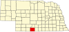
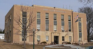
Furnas County is a county in the U.S. state of Nebraska. As of the 2020 United States Census, the population was 4,636. Its county seat is Beaver City. The county was named for Robert Wilkinson Furnas, the second governor of the state of Nebraska.
Elgin is a city in Antelope County, Nebraska, United States. The population was 661 at the 2010 census.
Louisville is a city in northern Cass County, Nebraska, United States. The population was 1,319 at the 2020 census.
Fairfield is a city in Clay County, Nebraska, United States. The population was 387 at the 2010 census. It is part of the Hastings, Nebraska Micropolitan Statistical Area.
Bennington is a city in Douglas County, Nebraska, United States. The population was 2,026 at the 2020 U.S. Census.
Arapahoe is a city in Furnas County, in the southern part of the state of Nebraska in the Midwestern United States. The population of the rural town was 1,026 at the 2010 census.
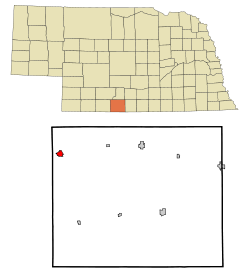
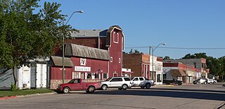
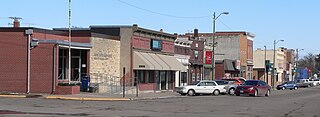
Beaver City is a city in Furnas County, on the southern border of Nebraska, United States. The population was 609 at the 2010 census. It is the county seat of Furnas County.
Edison is a village in Furnas County, Nebraska, United States. The population was 133 at the 2010 census.
Hendley is a village in Furnas County, Nebraska, United States. The population was 24 at the 2010 census.
Holbrook is a village in Furnas County, Nebraska, United States. The population was 207 at the 2010 census.
Wilsonville is a village in Furnas County, Nebraska, United States. The population was 93 at the 2010 census.
Burwell is a city in Garfield County, Nebraska, United States. The population was 1,210 at the 2010 census. It is the county seat of Garfield County.
Creighton is a city in Knox County, Nebraska, United States. The population was 1,154 at the 2010 census.
Waverly is a village in Lancaster County, Nebraska, United States. It is part of the Lincoln, Nebraska Metropolitan Statistical Area. The population was 4,279 at the 2020 census.
Brownville is a village in Nemaha County, Nebraska, United States. The population was 142 at the 2020 census.
Pawnee City is a city in and the county seat of Pawnee County, Nebraska, United States. The population was 878 at the 2010 census.
Ceresco is a farming village in Saunders County, Nebraska, United States. The population was 919 at the 2020 census. It is located near U.S. Highway 77, just north of Lincoln, just south of Wahoo, and a short distance southwest of Omaha.
Stanton is a city in Stanton County, Nebraska, United States. The population was 1,577 at the 2010 census. It is the county seat of Stanton County. Stanton was platted in 1870. Both the city and county are named after Edwin Stanton, secretary of war for president Abraham Lincoln during the American Civil War.
Deshler is a city in Thayer County, Nebraska, United States. The population was 739 at the 2020 census.
Oxford is a village in Furnas and Harlan counties in the U.S. state of Nebraska. The population was 779 at the 2010 census.