Cambridge Springs, Pennsylvania

Last updated
Cambridge Springs, Pennsylvania
Cambridge Springs, Pennsylvania.jpg
Downtown Cambridge Springs
Etymology: Cambridge, Massachusetts and nearby mineral springs
Crawford County Pennsylvania Incorporated and Unincorporated areas Cambridge Springs Highlighted.svg
Location of Cambridge Springs in Crawford County, Pennsylvania
USA Pennsylvania location map.svg
Red pog.svg
Cambridge Springs
Location of Cambridge Springs in Pennsylvania
Coordinates: 41°48′8″N80°3′33″W / 41.80222°N 80.05917°W / 41.80222; -80.05917
CountryUnited States
State Pennsylvania
County Crawford
Settled1822 (1822)
Government
  MayorDelores Hale
Area
[1]
  Total0.89 sq mi (2.30 km2)
  Land0.89 sq mi (2.30 km2)
  Water0.00 sq mi (0.00 km2)
Highest elevation
[2] (at water tank in southwest corner of borough)
1,300 ft (400 m)
Lowest elevation
[2] (French Creek at borough line)
1,130 ft (340 m)
Population
 (2020) [3]
  Total2,583
  Estimate 
(2022) [4]
2,339
  Density2,916.67/sq mi (1,125.77/km2)
Time zone UTC-5 (EST)
  Summer (DST) UTC-4 (EDT)
ZIP Code
16403 [5]
Area code 814

Cambridge Springs is a borough with home rule status in Crawford County, Pennsylvania, United States. The population was 2,583 at the 2020 census, [4] down from 2,595 at the 2010 census. [6]

Contents

History

The village of Cambridge was settled in 1822 and was named for the town of Cambridge, Massachusetts. [7] [8] It was incorporated into the borough of Cambridgeboro on April 3, 1866. [7] [9]

In the late 19th century, Cambridgeboro was known for its mineral springs. The discovery of the springs eventually led to renaming the borough to Cambridge Springs on April 1, 1897. [9] It was a resort town featuring a variety of hotels including the Rider Hotel, which burned down in 1931. The last of these hotels, the Riverside Inn, burned down on May 2, 2017, and had been listed in the National Register of Historic Places since 1978. Also listed on the National Register of Historic Places are the Cambridge Springs Bridge and Amos Kelly House. [10]

In 1904, the Rider Hotel in Cambridge Springs was the site of a famous chess tournament won by Frank Marshall ahead of World Champion Emanuel Lasker and fourteen other players. A variation of the Queen's Gambit Declined opening played several times there is today known as the Cambridge Springs Defense (1.d4 d5 2.c4 e6 3.Nc3 Nf6 4.Bg5 Nbd7 5.e3 c6 6.Nf3 Qa5 in algebraic notation).

From 1912 to 1987, it was home to Alliance College. In 1912, United States President William Howard Taft traveled to Cambridge Springs for the dedication. The site of the college is now occupied by State Correctional Institution – Cambridge Springs, a minimum-security prison.

In the early 20th century, the town became a "veritable 'Mecca' to chronic hoboes" who were interested in meeting Leon Ray Livingston, the famed hobo and author who had established Cambridge Springs as his home base while not traveling.

The borough adopted a home rule charter on May 21, 1974, that took effect on January 5, 1976. [11] While the community's official name remains the "Borough of Cambridge Springs", it is no longer subject to the Pennsylvania Borough Code.

Geography

Cambridge Springs is located in north-central Crawford County at 41°48′8″N80°3′33″W / 41.80222°N 80.05917°W / 41.80222; -80.05917 (41.802324, -80.059174). [12] It is surrounded by Cambridge Township, a separate municipality.

U.S. routes 19 and 6 pass together through Cambridge Springs, leading north 7 miles (11 km) to their split near Mill Village and south 12 miles (19 km) to Meadville, the Crawford County seat. Erie is 25 miles (40 km) north of Cambridge Springs via US 19. Pennsylvania Route 99 leads northwest from Cambridge Springs 7 miles (11 km) to Edinboro, PA 86 leads south 4 miles (6 km) to Woodcock, and PA 408 leads southeast 27 miles (43 km) to Titusville.

According to the United States Census Bureau, the borough has a total area of 0.872 square miles (2.26 km2), all land. [6] French Creek, a tributary of the Allegheny River, flows through the northern part of Cambridge Springs.

Demographics

Historical population
CensusPop.Note
1870 452
1880 67449.1%
1890 91235.3%
1900 1,49563.9%
1910 1,5141.3%
1920 1,6639.8%
1930 1,6650.1%
1940 1,8078.5%
1950 2,24624.3%
1960 2,031−9.6%
1970 1,998−1.6%
1980 2,1025.2%
1990 1,837−12.6%
2000 2,36328.6%
2010 2,5959.8%
2020 2,583−0.5%
2022 (est.)2,339 [4] −9.4%
Sources: [13] [14] [15] [16] [17] [3]

As of the 2010 United States Census, there were 2,595 people, 675 households, and 484 families residing in the borough. The population density was 2,975.9 inhabitants per square mile (1,149.0/km2). There were 741 dwelling units at an average density of 857.8 per square mile (331.2/km2). The racial makeup of the borough was 84.9 percent White, 12.8 percent African American, 0.3 percent Native American, 0.3 percent Asian, 0.9 percent from other races, and 0.7 percent from two or more races. Hispanics or Latinos of any race were 3.5 percent of the population.

There were 675 households, out of which 21.7 percent had children under the age of 18 living with them, 40.7 percent were married couples living together, 19.0 percent had a female householder with no husband present, and 48.4 percent were non-families. 33.2% of all households were made up of individuals, and 13.8% had someone living alone who was 65 years of age or older. The average household size was 2.38 and the average family size was 3.04.

The age distribution was 19.0% under 18, 8.8% from 18 to 24, 40.9% from 25 to 44, 18.2% from 45 to 64, and 13.2% who were 65 or older. The median age was 36 years. For every 100 females, there were 54.8 males. For every 100 females age 18 and over, there were 46.4 males.

The median income for a household in the borough was $31,957, and the median income for a family was $39,196. Males had a median income of $31,146 versus $22,350 for females. The per capita income for the borough was $12,863. About 8.7% of families and 12.2% of the population were below the poverty line, including 16.1% of those under age 18 and 12.0% of those age 65 or over.

See also

Related Research Articles

<span class="mw-page-title-main">Crawford County, Pennsylvania</span> County in Pennsylvania, United States

Crawford County is a county in the Commonwealth of Pennsylvania. As of the 2020 census, the population was 83,938. Its county seat is Meadville. The county was created on March 12, 1800, from part of Allegheny County and named for Colonel William Crawford. The county is part of the Northwest Pennsylvania region of the state.

<span class="mw-page-title-main">West Liberty, Pennsylvania</span> Borough in Pennsylvania, United States

West Liberty is a borough in Butler County, Pennsylvania, United States. The population was 343 at the 2010 census.

<span class="mw-page-title-main">Modena, Pennsylvania</span> Borough in Pennsylvania, United States

Modena is a borough in Chester County, Pennsylvania, United States. The population was 544 at the 2020 census. It was originally called Modeville, after the local Mode family.

<span class="mw-page-title-main">Blooming Valley, Pennsylvania</span> Borough in Pennsylvania, United States

Blooming Valley is a borough in Crawford County, Pennsylvania, United States. The population was 342 at the 2020 census, up from 337 at the 2010 census.

<span class="mw-page-title-main">Cambridge Township, Crawford County, Pennsylvania</span> Township in Pennsylvania, United States

Cambridge Township is a township in Crawford County, Pennsylvania, United States. The population was 1,447 at the 2020 census.

<span class="mw-page-title-main">Centerville, Crawford County, Pennsylvania</span> Borough in Pennsylvania, United States

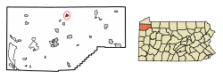
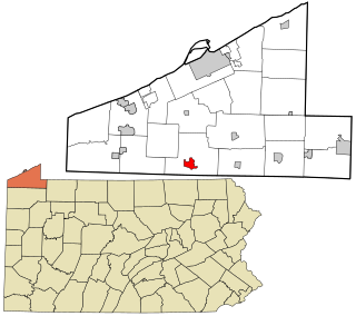
Centerville is a borough in Crawford County, Pennsylvania, United States. The population was 176 at the 2020 census, down from 218 at the 2010 census. It was established in 1812.

<span class="mw-page-title-main">Cochranton, Pennsylvania</span> Borough in Pennsylvania, United States

Cochranton is a borough in Crawford County, Pennsylvania, United States. The population was 1,124 at the 2020 census, down from 1,136 as of the 2010 census.

<span class="mw-page-title-main">Conneaut Lake, Pennsylvania</span> Borough in Pennsylvania, United States

Conneaut Lake is a borough in Crawford County, Pennsylvania, located at the southern end of the lake of the same name. The population was 625 at the 2020 census, down from 653 at the 2010 census.

<span class="mw-page-title-main">Conneaut Lakeshore, Pennsylvania</span> Census-designated place in Pennsylvania, United States

Conneaut Lakeshore is a census-designated place (CDP) in Crawford County, Pennsylvania, United States. The population was 2,395 at the 2010 census.

<span class="mw-page-title-main">Conneautville, Pennsylvania</span> Borough in Pennsylvania, United States

Conneautville is a borough in Crawford County, Pennsylvania, United States, situated along Conneaut Creek. The population was 736 at the 2020 census, down from 774 at the 2010 census.

<span class="mw-page-title-main">Hydetown, Pennsylvania</span> Borough in Pennsylvania, United States

Hydetown is a borough in Crawford County, Pennsylvania, United States. The population was 526 at the 2020 census, up from 526 at the 2010 census, down from 605 in 2000. It was established in 1862.

<span class="mw-page-title-main">Linesville, Pennsylvania</span> Borough in Pennsylvania, United States

Linesville is a borough in Crawford County, Pennsylvania, United States. The population was 961 at the 2020 census, down from 987 at the 2019 census. The town derives its name from its founders, who included William Line, who migrated from Carlisle, Pennsylvania, circa the early 1820s, and his relative, Amos Line, who was the town's surveyor and main proprietor. Amos Line "penetrated the western Pennsylvania wilderness as a member of the Pennsylvania Population Company in the early 1800s."

<span class="mw-page-title-main">Saegertown, Pennsylvania</span> Borough in Pennsylvania, United States

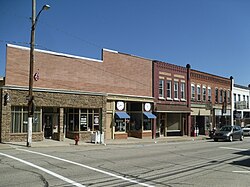
Saegertown is a borough in Crawford County, Pennsylvania. The population was 869 at the time of the 2020 census, down from 997 at the 2010 census. It was established in 1824.

<span class="mw-page-title-main">Spring Township, Crawford County, Pennsylvania</span> Township in Pennsylvania, United States

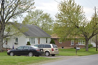
Spring Township is a township in Crawford County, Pennsylvania, United States. The population was 1,407 at the 2020 census, down from 1,548 at the 2010 census.

<span class="mw-page-title-main">Springboro, Pennsylvania</span> Borough in Pennsylvania, United States

Springboro is a borough in Crawford County, Pennsylvania, United States, located 35 miles southwest of Erie. The population was 376 at the 2020 census, down from 477 at the 2010 census.

<span class="mw-page-title-main">Townville, Pennsylvania</span> Borough in Pennsylvania, United States

Townville is a borough in Crawford County, Pennsylvania, United States. The population was 326 at the 2020 census, up from 323 at the 2010 census.

<span class="mw-page-title-main">Venango, Pennsylvania</span> Borough in Pennsylvania, United States

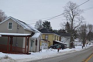
Venango is a borough in Crawford County, Pennsylvania, United States. The population was 210 at the 2020 census, down from 239 at the 2010 census, down from 288 in 2000.

<span class="mw-page-title-main">Woodcock, Pennsylvania</span> Borough in Pennsylvania, United States

Woodcock is a borough in Crawford County, Pennsylvania, United States. The population was 140 at the 2020 census, down from 157 at the 2010 census.

<span class="mw-page-title-main">Edinboro, Pennsylvania</span> Borough in Pennsylvania, United States

Edinboro is a borough in Erie County, Pennsylvania, United States. It is part of the Erie Metropolitan Statistical Area. As home to Edinboro University of Pennsylvania, it is a small college town, as well as a resort community. The population was 4,920 at the 2020 census, down from 6,438 in 2010.

<span class="mw-page-title-main">Mill Village, Pennsylvania</span> Borough in Pennsylvania, United States

Mill Village is a borough in Erie County, Pennsylvania, United States. The population was 394 at the 2020 census, down from 412 during the 2010 census. It is part of the Erie Metropolitan Statistical Area.

References

  1. "ArcGIS REST Services Directory". United States Census Bureau. Retrieved October 12, 2022.
  2. 1 2 "Cambridge Springs Topo Map, Crawford County PA (Cambridge Springs Area)". TopoZone. Locality, LLC. Retrieved 1 September 2019.
  3. 1 2 "Census Population API". United States Census Bureau. Retrieved Oct 12, 2022.
  4. 1 2 3 Bureau, US Census. "City and Town Population Totals: 2020-2022". Census.gov. US Census Bureau. Retrieved August 24, 2023.
  5. "Cambridge Springs PA ZIP Code". zipdatamaps.com. 2023. Retrieved May 13, 2023.
  6. 1 2 "Geographic Identifiers: 2010 Census Summary File 1 (G001): Cambridge Springs borough, Pennsylvania". U.S. Census Bureau, American Factfinder. Archived from the original on February 13, 2020. Retrieved June 2, 2015.
  7. 1 2 Hottenstein, JoAnne; Welch, Sibyl (1965). "Crawford County" (PDF). Incorporation dates of Pennsylvania municipalities. Harrisburg: Bureau of Municipal Affairs, Pennsylvania Department of Internal Affairs. p. 49. Retrieved July 31, 2011.
  8. Bates, p. 490.
  9. 1 2 Bates, p. 493.
  10. "National Register Information System". National Register of Historic Places . National Park Service. July 9, 2010.
  11. Pennsylvania Code Title 320, Sec. 41.1-101 et seq. Archived 2005-09-01 at the Wayback Machine
  12. "US Gazetteer files: 2010, 2000, and 1990". United States Census Bureau. 2011-02-12. Retrieved 2011-04-23.
  13. "Census of Population and Housing". U.S. Census Bureau. Retrieved 11 December 2013.
  14. "U.S. Census website". United States Census Bureau . Retrieved 2008-01-31.
  15. "Incorporated Places and Minor Civil Divisions Datasets: Subcounty Resident Population Estimates: April 1, 2010 to July 1, 2012". Population Estimates. U.S. Census Bureau. Archived from the original on 11 June 2013. Retrieved 11 December 2013.
  16. Bureau, U. S. Census. "U.S. Census website". United States Census Bureau . US Census Bureau. Retrieved 17 July 2019.
  17. "Census of Population and Housing". Census.gov. Retrieved June 4, 2016.

Sources