Cameron, North Carolina

Last updated

Cameron, North Carolina
Town
Cameron, North Carolina.jpg
Moore County North Carolina incorporated and unincorporated areas Cameron highlighted.svg
Location in Moore County and the state of North Carolina.
Coordinates: 35°19′33″N79°15′15″W / 35.32583°N 79.25417°W / 35.32583; -79.25417
CountryUnited States
State North Carolina
County Moore
MayorJane Harbour Ethridge
Founded1875
Incorporated1876 [1]
Named for Paul Cameron [1]
Area
[2]
  Total1.21 sq mi (3.14 km2)
  Land1.21 sq mi (3.14 km2)
  Water0.00 sq mi (0.00 km2)
Elevation
[3]
338 ft (103 m)
Population
 (2020)
  Total244
  Density201.32/sq mi (77.72/km2)
Time zone UTC-5 (Eastern (EST))
  Summer (DST) UTC-4 (EDT)
ZIP code
28326 [4]
Area codes 910, 472
FIPS code 37-09800 [5]
GNIS feature ID2405369 [3]

Cameron is a town in Moore County, North Carolina, United States. The population was 359 at the 2020 census. [6]

Contents

History

Cameron grew up around a plank road that was followed in later years by a railroad. The town was planned in 1875 and incorporated in 1876. Cameron was at the end of the Raleigh and Augusta Railroad. Its location made it an ideal place for entrepreneurs to establish businesses. They built turpentine distilleries, established mercantile and hotel businesses to serve the needs of the railroad's customers and built a thriving dewberry farming and consignment operation.

Geography

According to the United States Census Bureau, the town has a total area of 1.0 square mile (2.6 km2), all land.

Neighboring towns include Vass to the south and Carthage to the west.

Demographics

Historical population
CensusPop.Note
1880 117
1890 236101.7%
1900 218−7.6%
1910 25918.8%
1920 241−6.9%
1930 28719.1%
1940 3118.4%
1950 284−8.7%
1960 2984.9%
1970 204−31.5%
1980 22510.3%
1990 215−4.4%
2000 151−29.8%
2010 28588.7%
2020 244−14.4%
U.S. Decennial Census [7]
Former rail depot in Cameron Cameron Depot.JPG
Former rail depot in Cameron

At the 2000 census there were 151 people, 66 households, and 41 families living in the town. The population density was 143.8 people per square mile (55.5 people/km2). There were 78 housing units at an average density of 74.3 per square mile (28.7/km2). The racial makeup of the town was 64.90% White and 35.10% Black. [5] Of the 66 households 25.8% had children under the age of 18 living with them, 40.9% were married couples living together, 18.2% had a female householder with no husband present, and 36.4% were non-families. 31.8% of households were one person and 16.7% were one person aged 65 or older. The average household size was 2.29 and the average family size was 2.88.

The age distribution was 17.9% under the age of 18, 9.9% from 18 to 24, 30.5% from 25 to 44, 20.5% from 45 to 64, and 21.2% 65 or older. The median age was 42 years. For every 100 females, there were 75.6 males. For every 100 females aged 18 and over, there were 82.4 males.

The median household income was $32,500 and the median family income was $41,964. Males had a median income of $32,917 versus $22,500 for females. The per capita income for the town was $15,337. There were 17.9% of families and 21.3% of the population living below the poverty line, including 13.5% of those under eighteen and 45.8% of those over 64.

Notable people

Related Research Articles

<span class="mw-page-title-main">Quitman, Missouri</span> Unincorporated community in Missouri, United States

Quitman is an unincorporated community in west central Nodaway County, Missouri, United States. The population was 45 at the 2010 census.

<span class="mw-page-title-main">Blasdell, New York</span> Village in New York, United States

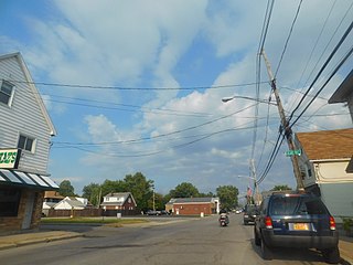
Blasdell is a village in Erie County, New York, United States. The population was 2,553 according to the 2010 Census. The name is derived from Herman Blasdell, the first station master of the Erie and Pennsylvania railroad depot. It is part of the Buffalo–Niagara Falls Metropolitan Statistical Area.

<span class="mw-page-title-main">Lansing, North Carolina</span> Town in North Carolina, United States

Lansing is a resort town in Ashe County, North Carolina, United States. The population was 126 at the 2020 census.

<span class="mw-page-title-main">Crossnore, North Carolina</span> Town in North Carolina, United States

Crossnore is a town in Avery County, North Carolina, United States. The population was 143 at the 2020 census.

<span class="mw-page-title-main">Clarkton, North Carolina</span> Town in North Carolina, United States

Clarkton is a town in Bladen County, North Carolina, United States. The population was 837 at the 2010 census.

Sandy Creek is a town in Brunswick County, North Carolina, United States. The population was 260 at the 2010 census. It is part of the Wilmington, NC Metropolitan Statistical Area.

<span class="mw-page-title-main">Mount Pleasant, North Carolina</span> Town in North Carolina, United States

Mount Pleasant is a town located in eastern Cabarrus County, North Carolina, United States. As of the 2010 census, the town population was 1,652. The town center is located at the crossroads of Mount Pleasant Road and North Carolina Highway 73. NC Highway 49 skirts the town to the north on its way from Charlotte to Asheboro.

<span class="mw-page-title-main">Cape Carteret, North Carolina</span> Town in North Carolina, United States

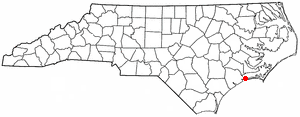
Cape Carteret is a town in Carteret County, on the southern coast of North Carolina, United States. It was incorporated in 1959 and had a population of 2,224 as of the 2020 census.

<span class="mw-page-title-main">Mooresboro, North Carolina</span> Town in North Carolina, United States

Mooresboro is a town in Cleveland County, North Carolina, United States. The population was 311 at the 2010 census.

<span class="mw-page-title-main">Hookerton, North Carolina</span> Town in North Carolina, United States

Hookerton is a town in Greene County, North Carolina, United States. The population was 409 at the 2010 census. It is geographically located southeast of Snow Hill on North Carolina Highway 123. The town is part of the Greenville Metropolitan Area.

<span class="mw-page-title-main">Southern Pines, North Carolina</span> Town in North Carolina, United States

Southern Pines is a town in Moore County, North Carolina, United States. The population was 12,334 as of the 2010 United States Census.

<span class="mw-page-title-main">Vass, North Carolina</span> Town in North Carolina, United States

Vass is a town in Moore County, North Carolina, United States. The population was 720 at the 2010 census. Vass grew up along the railroad in the late 19th century. It was originally named Bynum and later Winder before being established as Vass in 1892. The town was incorporated in 1907.

<span class="mw-page-title-main">Ellerbe, North Carolina</span> Town in North Carolina, United States

Ellerbe is a town in Richmond County, North Carolina, United States. The population was 1,054 at the 2010 census.

<span class="mw-page-title-main">Raynham, North Carolina</span> Town in North Carolina, United States

Raynham is a town in Robeson County, North Carolina, United States. The population was 72 at the 2010 census.

<span class="mw-page-title-main">Mayodan, North Carolina</span> Town in North Carolina, United States

Mayodan is a town in Rockingham County, North Carolina, in the United States. It is a manufacturing site for Sturm, Ruger & Co., Bridgestone Aircraft Tire, and formerly General Tobacco. Washington Mills Company, later Tultex, operated a textile mill in Mayodan until 1999.

<span class="mw-page-title-main">Walnut Cove, North Carolina</span> Town in North Carolina, United States

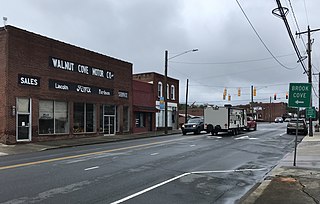
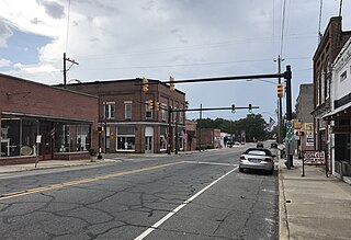
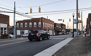
Walnut Cove is a town in Stokes County, North Carolina, United States. The population was 1,536 at the 2020 census.

<span class="mw-page-title-main">Peak, South Carolina</span> Town in South Carolina, United States

Peak is a town in Newberry County, South Carolina, United States. The population was 64 at the 2010 census.

<span class="mw-page-title-main">Cameron, West Virginia</span> City in West Virginia

Cameron is a city in Marshall County, West Virginia, United States. It is part of the Wheeling metropolitan area. The population was 849 at the 2020 census.

<span class="mw-page-title-main">Stratford, Wisconsin</span> Village in Wisconsin, United States

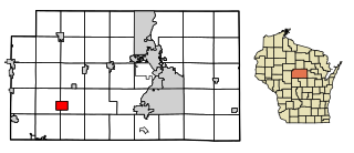
Stratford is a village in Marathon County, Wisconsin, United States. It is part of the Wausau, Wisconsin Metropolitan Statistical Area. The population was 1,578 at the 2010 census.

<span class="mw-page-title-main">Weddington, North Carolina</span> Town in North Carolina, United States

Weddington is a suburban town in Union County, North Carolina, United States. The population was 9,459 at the 2010 census. It is a suburb in the Charlotte metropolitan area. The current mayor of Weddington is Jim Bell.

References

  1. 1 2 "Cameron Town, Moore County, North Carolina (NC)". Living Places. Archived from the original on March 30, 2023. Retrieved December 8, 2022.
  2. "ArcGIS REST Services Directory". United States Census Bureau. Archived from the original on January 19, 2022. Retrieved September 20, 2022.
  3. 1 2 U.S. Geological Survey Geographic Names Information System: Cameron, North Carolina
  4. "Cameron NC ZIP Code". zipdatamaps.com. 2023. Archived from the original on February 26, 2023. Retrieved February 17, 2023.
  5. 1 2 "U.S. Census website". United States Census Bureau. Archived from the original on July 9, 2021. Retrieved January 31, 2008.
  6. "Metropolitan and Micropolitan Statistical Areas Totals: 2010-2020". Census.gov. Archived from the original on May 5, 2021. Retrieved June 3, 2022.
  7. "Census of Population and Housing". Census.gov. Archived from the original on March 21, 2021. Retrieved June 4, 2015.