Camp Lacupolis, Minnesota

Last updated
Camp Lacupolis
USA Minnesota location map.svg
Red pog.svg
Camp Lacupolis
Location of the community of Camp Lacupolis
within Pepin Township, Wabasha County
Usa edcp location map.svg
Red pog.svg
Camp Lacupolis
Camp Lacupolis (the United States)
Coordinates: 44°24′34″N92°06′56″W / 44.40944°N 92.11556°W / 44.40944; -92.11556 Coordinates: 44°24′34″N92°06′56″W / 44.40944°N 92.11556°W / 44.40944; -92.11556
Country United States
State Minnesota
County Wabasha County
Township Pepin Township
Elevation
709 ft (216 m)
Time zone UTC-6 (Central (CST))
  Summer (DST) UTC-5 (CDT)
ZIP code
55041
Area code(s) 651
GNIS feature ID640813 [1]

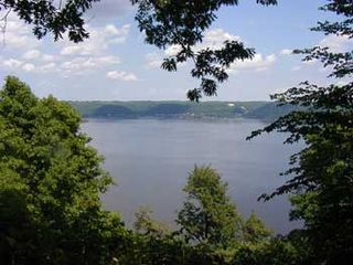
Camp Lacupolis is an unincorporated community in Pepin Township, Wabasha County, Minnesota, United States, along the Mississippi River and Lake Pepin.

Unincorporated area Region of land not governed by own local government

In law, an unincorporated area is a region of land that is not governed by a local municipal corporation; similarly an unincorporated community is a settlement that is not governed by its own local municipal corporation, but rather is administered as part of larger administrative divisions, such as a township, parish, borough, county, city, canton, state, province or country. Occasionally, municipalities dissolve or disincorporate, which may happen if they become fiscally insolvent, and services become the responsibility of a higher administration. Widespread unincorporated communities and areas are a distinguishing feature of the United States and Canada. In most other countries of the world, there are either no unincorporated areas at all, or these are very rare; typically remote, outlying, sparsely populated or uninhabited areas.

Pepin Township, Wabasha County, Minnesota Township in Minnesota, United States

Pepin Township is a township in Wabasha County, Minnesota, United States. The population was 471 at the 2000 census. The unincorporated communities of Maple Springs, Camp Lacupolis and Reads Landing are located within the township.

Wabasha County, Minnesota County in the United States

Wabasha County is a county in the U.S. state of Minnesota. As of the 2010 United States Census, the population was 21,676. Its county seat is Wabasha.

The community is located between Lake City and Wabasha along U.S. Highway 61 near 223rd Avenue.

U.S. Highway 61 (US 61) is a U.S. Highway in southeast and east-central Minnesota, which runs from the River Bridge over the Mississippi River at La Crescent and continues north to its northern terminus at its junction with Interstate 35 at the city of Wyoming.

Nearby places include Lake City, Wabasha, Maple Springs, and Reads Landing.

Lake City, Minnesota City in Minnesota, United States

Lake City is a city in Goodhue and Wabasha counties in the U.S. state of Minnesota. It lies along Lake Pepin, a wide portion of the Mississippi River. The population was 5,063 at the 2010 census. Most of Lake City is located within Wabasha County with only a small portion in Goodhue County.

Wabasha, Minnesota City in Minnesota, United States

Wabasha is a city in Wabasha County, Minnesota, United States. The population was 2,521 at the 2010 census. Located on the Mississippi River near its confluence with the Chippewa River, it is the county seat.

Maple Springs, Minnesota Unincorporated community in Minnesota, United States

Maple Springs is an unincorporated community in Pepin Township, Wabasha County, Minnesota, United States, along the Mississippi River and Lake Pepin. The Mississippi River and King Creek meet at Maple Springs.

It is a historic fishing community along the Mississippi River and Lake Pepin known for its resorts. The name Camp Lacupolis means "Camp Lake City" in Greek. [2]

Related Research Articles

Mississippi River largest river system in North America

The Mississippi River is the second-longest river and chief river of the second-largest drainage system on the North American continent, second only to the Hudson Bay drainage system. Its source is Lake Itasca in northern Minnesota and it flows generally south for 2,320 miles (3,730 km) to the Mississippi River Delta in the Gulf of Mexico. With its many tributaries, the Mississippi's watershed drains all or parts of 32 U.S. states and two Canadian provinces between the Rocky and Appalachian mountains. The main stem is entirely within the United States; the total drainage basin is 1,151,000 sq mi (2,980,000 km2), of which only about one percent is in Canada. The Mississippi ranks as the fourth-longest and fifteenth-largest river by discharge in the world. The river either borders or passes through the states of Minnesota, Wisconsin, Iowa, Illinois, Missouri, Kentucky, Tennessee, Arkansas, Mississippi, and Louisiana.

Pepin County, Wisconsin County in the United States

Pepin County is a county in the U.S. state of Wisconsin. As of the 2010 census, the population was 7,469, making it the fourth-least populous county in Wisconsin. Its county seat is Durand.

Winona County, Minnesota County in the United States

Winona County is a county in the U.S. state of Minnesota. As of the 2018 census, its estimated population was 50,825. Its county seat is Winona.

Goodhue County, Minnesota County in the United States

Goodhue County is a county in the U.S. state of Minnesota. As of the 2010 census, the population was 46,183. Its county seat is Red Wing. Nearly all of Prairie Island Indian Community is within the county.

Nelson is a town in Buffalo County in the U.S. state of Wisconsin. The population was 571 at the 2010 census. The village of Nelson is located within the town. The unincorporated communities of Misha Mokwa and Trevino are located in the town. The unincorporated community of Urne is located partially in the town.

Lake Pepin natural lake on the Mississippi River in Minnesota and Wisconsin, United States

Lake Pepin is a naturally occurring lake on the Mississippi River on the border between the U.S. states of Minnesota and Wisconsin. It is located in a valley carved by the outflow of an enormous glacial lake at the end of the last Ice Age. The lake formed when the Mississippi, a successor to the glacial river, was partially dammed by a delta from a tributary stream and spread out across the ancient valley.

Zumbro River river in the United States of America

The Zumbro River is a tributary of the Mississippi River in the Driftless Area of southeastern Minnesota in the United States. It is 64.6 miles (104.0 km) long from the confluence of its principal tributaries and drains a watershed of 1,428 square miles (3,700 km2). The river's name in English is a change from its French name Rivière des Embarras due to its mouth located near Pine Island in the Mississippi River; the Dakota name for this river is Wapka Wazi Oju, having reference to the grove of great white pines at Pine Island.

Frontenac State Park

Frontenac State Park is a state park of Minnesota, United States, on the Mississippi River 10 miles (16 km) southeast of Red Wing. The park is notable both for its history and for its birdwatching opportunities. The centerpiece of the park is a 430-foot-high (130 m), 3-mile-long (4.8 km) steep limestone bluff overlooking Lake Pepin, a natural widening of the Mississippi. The bluff is variously called Garrard's Bluff or Point No-Point, the latter name coming from riverboat captains because of the optical illusion that it protruded into the Mississippi River. There is a natural limestone arch on the blufftop called In-Yan-Teopa, a Dakota name meaning "Rock With Opening". Park lands entirely surround the town of Frontenac, once a high-class resort at the end of the 19th century.

Upper Mississippi River National Wildlife and Fish Refuge

The Upper Mississippi River National Wildlife and Fish Refuge is a 240,000-acre (970 km2), 261-mile long (420 km) National Wildlife Refuge located in and along the Upper Mississippi River. It runs from Wabasha, Minnesota in the north to Rock Island, Illinois in the south.

Weaver, Minnesota Unincorporated community in Minnesota, United States

Weaver is an unincorporated community in Minneiska Township, Wabasha County, Minnesota, United States. The Whitewater River and the Mississippi River meet at Weaver.

West Albany, Minnesota Unincorporated community in Minnesota, United States

West Albany is an unincorporated community in West Albany Township, Wabasha County, Minnesota, United States.

Reads Landing, Minnesota Unincorporated community in Minnesota, United States

Reads Landing is an unincorporated community in Pepin Township, Wabasha County, Minnesota, United States, along the Mississippi River.

Wacouta, Minnesota Unincorporated community in Minnesota, United States

Wacouta is an unincorporated community in Wacouta Township, Goodhue County, Minnesota, United States.

Bear Valley, Minnesota Unincorporated community in Minnesota, United States

Bear Valley is an unincorporated community in Chester Township, Wabasha County, Minnesota, United States.

Reads Landing School building in Reads Landing, Minnesota, United States

Reads Landing School is a former school building in the unincorporated community of Reads Landing, Minnesota, United States. Built in 1870, it has been converted into the Wabasha County Historical Society Museum. The building is one of the state's oldest surviving brick schools, and typifies their characteristic boxy, bracketed, Italianate style. The school was listed on the National Register of Historic Places in 1989 for having local significance in the themes of architecture and exploration/settlement. It was nominated for being a rare surviving example of Minnesota's early brick schools, and for its association with Reads Landing's peak as a lumber milling boomtown.

References

  1. "Camp Lacupolis, Minnesota". Geographic Names Information System . United States Geological Survey.
  2. Camp Lacupolis site